
A concept sketch of how the fort would have looked on Isle Royale in 1759.

Flooded by the St. Lawrence Seaway project, whatever remains of the 1759 island fort are currently underwater.
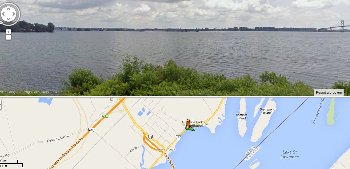
A 250 year old island stronghold underwater near Prescott, On
Driving south of Ottawa on the 416 for about an hour you can cross the border into the United States over a bridge which spans the St. Lawrence River near Prescott. Like thousands of others travelers, I’ve crossed the suspension bridge at a great height over the water and islands below, gazing in wonder at the mighty river that connects the Atlantic Ocean to the Great Lakes. But it is only now that I am discovering there is a submerged fortress island of great historical significance in the waters below.

When you think about old forts in the area, you usually think of Fort Henry in Kingston, but there is a much older fort, and its remnants lie under the waves just an hour away. While doing some research on another topic I came across an excerpt from a 1876 book on forts. The old book mentions ruins of a fort called “Fort Levis” near Prescott.
Excerpt from 1876 book mentioning ruins of a Fort near Prescott.
Upon further investigation it turns out this island fortress was the final stronghold for French forces during the Seven Years War with Britain in 1760 and was flooded out in 1959 along with countless other islands during the construction of the St. Lawrence Seaway. Today only a small portion of the island is visible above water. Most of it, including the fort area lies underwater. Let’s rewind time and take a closer look…

Flooded out in the 1950s, Chimney island was once Isle Royale.
Called “Isle Royale” by the French in 1759, a decision was made to build a fortification on the 800 foot island in the middle of the St. Lawrence to repel any invading British ships making their way up the river from Kingston. Abandoning a previous fort near Ogdensburg the French built the island fortress as a last ditch effort against the advancing British ships trying to take Montreal. Armed with cannons, a moat, ramparts, palisades and other fortress features, it was called FORT LEVIS. The island army even grew a their own vegetables in a garden on the east end of the island.
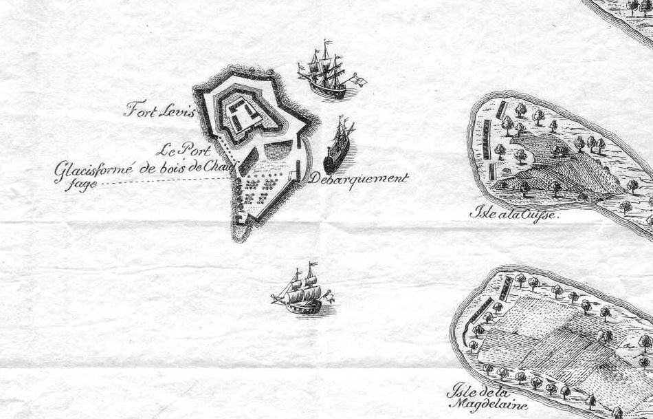
A French map from 1759 indicates Isle Royale and Fort Levis built upon it.
Originally to be built of stone, plans changed due to time restraints and Fort Levis was built out of wood and measured about 350 square with bastions in each of the corners. A loading dock area for supplies was on the north shore facing the Canadian side of the river. French Commander Pierre Pouchot took command of the island fort and prepared to defend what was soon to be a short lived fortress.
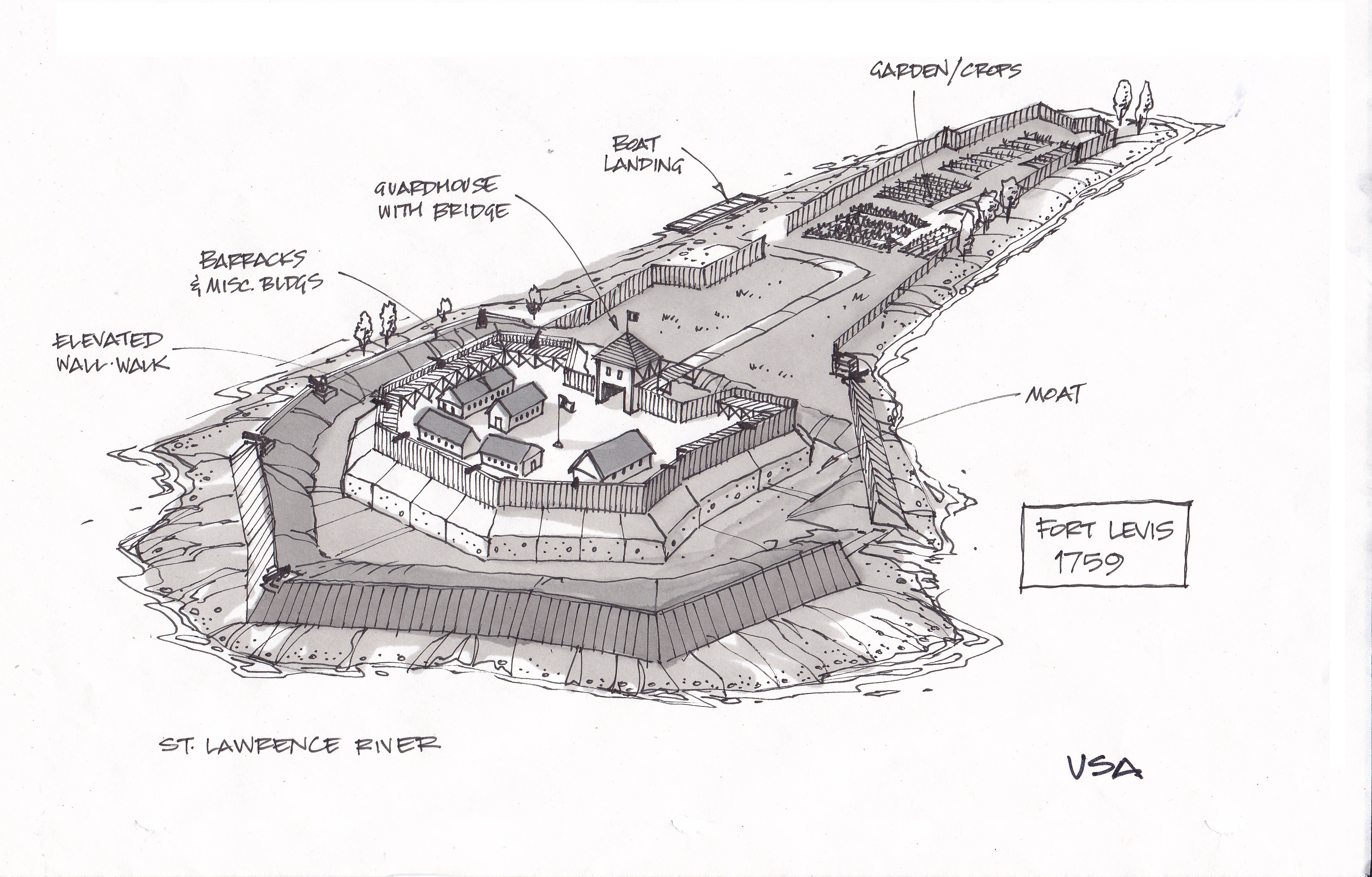
Sketch showing the island as it appeared in 1759 with the defensive features of Fort Levis.
It didn’t take the British long to begin their advance up the St. Lawrence River in their gunboats towards capturing Montreal so the fort was put into immediate action. French lookouts near Alexandria Bay saw two approaching British gunships, the Mohawk and Onondaga, and raced back to the fort and braced for impending attack.
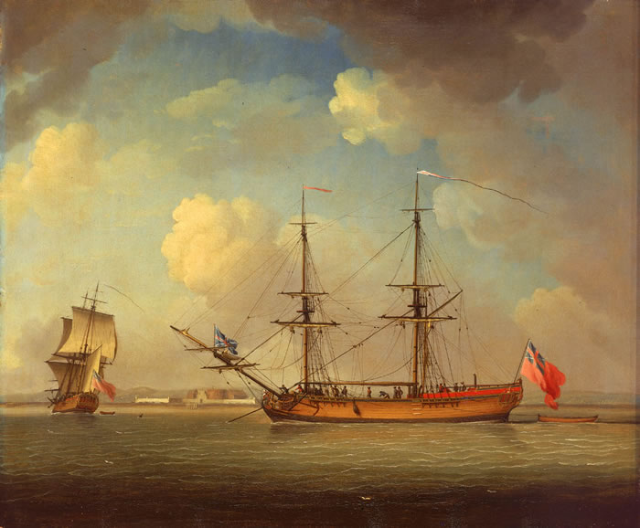
British gunships, Mohawk and Onondaga advanced up the St. Lawrence through the 1000 Islands towards Fort Levis.
The two British ships got lost in the maze of the Thousands Islands for a week, giving the French time to prepare for battle. The British ships managed to capture a French gunboat along the way, hoisting a British flag and re-naming it the Williamson and adding it to its fleet of now three ships to take on the newly constructed Fort Levis ahead. Surrounding the island fortress were other islands, now held by the British with cannons stationed and aimed at the French fort. Under the command of Major-General Amherst, the three British ships arrived at Fort Levis on August 19 1760 and a fierce Battle Of The Thousand Islands began.
The island fortress threw everything it had against the looming British trio of ships, blasting the newly captured Williamson 48 times with cannon fire. Amherst called a ceasefire and retreated for the night. At dawn the fort once again rained cannon fire upon the British ships while also repelling invading troops trying to storm the shores of the island. During the skirmish the fort managed to sink both the Williamson and the Onondaga to the bottom of the St. Lawrence. The island fort did not let up its defensive attack and Commander Pouchot pummeled the remaining ship, the Mohawk, with cannon fire, sinking it also. Three ships sunk. The British had nothing left to attack the fort with except their island cannons surrounding Fort Levis.

A British map from 1760 shows the captured French fort they later re-named “Fort William Augustus”
Surprised at the unbelievable tenacity of the island fort to protect itself from all angles, Amherst gave the go-ahead to switch the cannons to “hotshot”, balls of fire that would set ablaze whatever they impacted. British hotshot rained down on Fort Levis, and with the fort on fire and having exhausted all their ammo, Pouchot finally surrendered the besieged island to the British. Originally armed with 300 soldiers, the French lost 275 men during the battle. The British lost 26 men. The fierce week long island battle was to be a decisive and final fight between French & British troops on the continent. The island fort was rebuilt and renamed Fort William Augustus under the British, with Amherst carrying on to join other British troops that surrounded Montreal. On September 6, 1760 Montréal was surrendered by New France’s governor, the Marquis de Vaudreuil which brought an end to the French empire in Canada. The island fort was the last stronghold for the French and its loss to the British signaled the end to the war.


It is unclear what happened to the fort between 1760 and 1950 when the St. Lawrence Seaway began construction. A study of aerial images produced in 1954 reveals the outline of the fort ruins were still visible on the island before it was submerged. Whatever remained of the original fort slowly slipped underwater in 1959 when flood waters raised levels for the new seaway.

Comparison of the island fortress then and now.
All that remains today of this important and decisive piece of Canadian history is a small patch of rock and grass now called Chimney Island which can be seen just east of the Prescott International Bridge. Whatever remnants of this 250 year old island fortress and its fierce past now rests quietly under the waves of the St. Lawrence River.
SOURCES:
http://en.wikipedia.org/wiki/Fort_Lévis
http://en.wikipedia.org/wiki/Battle_of_the_Thousand_Islands
http://www.ogdensburg.info/maps/maps.html
http://en.wikipedia.org/wiki/Snow_(ship)
Google Maps
Bing Maps

I had no idea, thank you for all these wonderful details.
Thanks for reading and your interest…it is exciting to learn about such fascinating history right here in our backyards!
The greater part of the island was destroyed by the construction of the Seaway; not merely flooded but excavated into oblivion.
Thanks for your comments and interest. I am sorry to hear the remains of the fort were destroyed before the island was flooded.
Fort Levis does not lie submerged under the St. Lawrence River. During construction of the Seaway, one half of the island was dredged, and dumped on top of the other half. Ruins of the fort – well preserved for several hundred years due to the fact that no farming/tilling was ever done on the island – were extant prior to construction of the Seaway. It likely was among the best preserved period forts on the continent but was allowed to be destroyed; a horrible shame. I have in my possession musket balls as well as a British coin from the early part of the 18th century which I found on the island many years ago.
Thanks for your comments and information regarding Fort Levis. Just to clarify, I do not claim the fort is perfectly preserved sitting underwater, just whatever remains of it lie under the waves. I assumed whatever was left of it was washed away, but thanks to your info, it seems that it remained quite intact until it was destroyed for the Seaway project. A terrible shame if it was indeed a well preserved fort up until then. Thanks for this new insight and that is cool you have some artifacts from the time when it was an operational fort!
Thanks, and appreciate the excellent article. My interest in the fort also stems from the fact that my eighth-great grandfather, Pierre Boucher de la Brocquerie, commanded one of two French corvettes during the battle, the l’Outaouaise, which was captured by Amherst, repaired and returned to the battle, only to be sunk by the French. Pierre, wounded in the battle, died two years later.
wow! That is quite a connection indeed! Great to hear from folks like yourself about this story…thank you.
Ted is correct. To make room for the shipping channel the north half of the island was removed and dumped onto the south half of the island. There is no reason to believe that any of the fort remains “under the waves.” More likely the remains are still on the remaining portion of the island however they would be under several feet, or more, of dredging debris. For me the interesting point is that if the posting is correct there should be the remains of three sunken ships in the area known as Chimney Island. I have lived on that area of the river for the past 6 decades and have never heard of anyone finding any of these wrecks. If you are interested in finding history enjoy the hunt. The River has much to offer, ENJOY!
Great to hear this feedback, as it was unclear to me what happened to the remains of the fort before the flooding. Thanks for the info and I appreciate you taking the time to comment. The ships you mention were later re-surfaced and repaired back into service by the British so their whereabouts today is a mystery.
There wheqreabouts is not a mystery. A little more research is required on your part. What fun would it be if I did your research? 😉
There are no sunken ships in the vicinity of the island. Further investigation will show you they ended their lives elsewhere. They were shot up in the battle, not sunk.
According to the book “Battlefields of Canada”
By Mary Beacock Fryer, the British ships Williamson (formerly French ship L’Outaouise) and Onondaga were sunk by the French off Fort Levis during the battle. They were later re-surfaced, repaired and returned to service.
the reason that no wrecks have been found is that the seaway project dredged them out before divers really hit the area and destroyed much of the historical evidence from the bottom
I grew up in Prescott during the building of the seaway and had no idea of this historical event, thanks for sharing
Thanks for reading and I only hope to share and spread the word about the fascinating history in our area…any feedback or additional information to enhance the story is always welcomed and appreciated.
It was reported that there was a chapel on the island. Before the French surrendered, they took anything of value, put it into the barrel of one of the cannons and dropped it into the river to prevent the English from capturing it. This tale was related to me by several of Fort Wellington’s curators over the years. How true it is, who knows. Interesting story.
That is a fascinating piece of lore that adds to the mystery of the island…Thanks for sharing.
Yes I also was born in Prescott, and I know of this Fort. I left Prescott in 1957,just after the seaway started. there was a lot of talk about it back then
Thanks for your interest! Yes, quite a shame about the island being dredged.
I lived in Cardinal during the time of the building of the seaway and also had on idea of what was there. I would probably say if this was known today it would have been preserved.
This is very interesting. I never knew this was literately in my backyard.(I live 10 minutes east of there near Cardinal) Would be a interesting site to behold for underwater divers. Would love to see underwater pictures if anyone ever ventures down to see what is left. Thank you for sharing this..
Thanks for your comments and interest in the island fort…As many have mentioned, the island was dredged heavily for the Seaway project and any remnants of the fort are most likely buried and underwater, but who knows what could be found underneath it all…
couldn’t tell you how many times i’ve crossed the river…wow…more news..more history…thanks
Glad to have you along! Thanks for your interest.
The only problem with the article is that they have the river running the wrong way. Kingston is up rive at the northeast end of Lake Ontario and Montreal is at the farthest downstream port where the river enters the gulf of St. Lawrence on its way to the Atlantic Ocean. Other than that an interesting story. Dan Mossien
My apologies, you are correct…Having grown up in Kingston we would always say “up the river” because it was north of us, therefore it was always “up” for us geographically…It is correct that it is actually “downriver” from Kingston in terms of flow. Thanks for your interest!
This is a fascinating story and real tragedy that this historic fort was destroyed during the Seaway Construction. Sometimes we are so short sighted. Thank you for sharing this.
Thank you for showing an interest in a piece of history lost to progress. Glad to have you along!
Great story. Not one that would have been remembered if not for someone like yourself. Canada needs more stories like this to help increase interest in our heritage.
Well done sir.
Thanks Sean, I appreciate your interest and hope to have you along for more fascinating history mysteries!
Reblogged this on Wayfaring Canuck and commented:
This is a great piece concerning the history surrounding my hometown, and something I never knew about. To get a story like this about the very stretch of river behind me in my profile photo, is very, very cool.
WOW! Great pic! Thanks for your interest in the history of our area and I hope you enjoyed learning about the island fort.
Reblogged this on Chris Drew and commented:
Interesting article.
Thanks Chris.
Wow! I just shared this whole article with my kids and our cousins. We are having a March break get together.their ages are 6,7,8.16and 19. They found this fascinating, as did I! I had no idea about this island. indeed an incredible part of our Canadian history!
Thanks very much for your comments and interest in this piece of history. It makes doing the blog worthwhile to hear that others enjoy the material and learn from it. Wishing you and the kids an enjoyable MArch Break!
Fascinating piece of history – thanks so much for posting (and thanks to the commenters for the additional information). Just one little point from a sailor – you’ve said the purpose of the port was to “repel any invading British ships making their way up the river from Kingston” and that the British “advance(d) up the St. Lawrence River” towards Montreal. In both cases, that should be down, not up. Kingston is up the river from Prescott and Montreal, so British ships coming from Kingston would be moving downriver.
Thank you and you are correct…my apologies…Having grown up in Kingston we would always say “up the river” because it was north of us, therefore it was always “up” for us geographically…It is correct that it is actually “downriver” from Kingston in terms of flow. Thanks for your interest!
What great research you are doing. Have you been to the Lost Villages Museum? Interesting artifacts.
Great article! We live in the U.S. I grew up near Ogdensburg and my wife is from Ogdensburg. My wife and I both have a great Canadian heritage from just across the river. We have enjoyed your information and will be sure to pass the article on to our family and friends. Thank you for sharing with us!
Thank you for your interest and I hope you and others enjoy sharing the information on this fascinating piece of history.
Dave, did you ever go to ofa back in the 70 s ?
I just found out about this old fort from a 90 year old cousin of my fathers who told me to take a look at this old Canadian history .. I have to admit I found it very interesting , so Thanks for posting it .. I read a number of years ago now all the ships that have been sunk in the Great Lakes over the years . The estimated number was hard to believe .. It was in the hundreds if I’m correct .
So much history above and below the waves of the St. Lawrence…thanks for your interest!
Lovely article, and a lovely illustration. Can you tell us who drew that nice sketch? There’s no credit given on the web page…
Why thanks! I drew the sketch of the fort based on the information from the old maps. Glad you enjoyed the article.
Nice article. I am going to share it with a group of 18th century living historians. I may use the information my next novel.
Thanks for your comments and interest, I hope it inspires you!
My family had a summer home on Baycroft Island–just across the shipping lane from Cornwall. Of course, it was plowed under for the Seaway expansion. In the late 1980’s, we were on a day trip and decided to drive along that area and we actually pulled over and walked to the water’s edge. A young fellow with a boat came along and we asked if we could hire him to take us over. His Mom was a dear, said yes and off we went. What we recognized were about 5-6 islands pushed together and as we drifted close to shore, I looked up at a tree and there hung a sign made by my father in 1948 “Julie’s Treehouse”!! No treehouse, of course, but my sign had remained and probably still does—I’m Julie and I’m 71 years old!!!
What a great although sad story….So many memories for people growing up along the St. Lawrence are associated with the Seaway Project. Thanks for your comments and welcome to the treehouse!
I recall reading that the French force (300?) was greatly outnumbered by the British (perhaps 10,000 or more). If this correct, the battle should be remembered as the Canadian Alamo. Of course it isn’t since the French lost the war, but they did fight very bravely and should be remembered. I also recall that there is a small marker on the river side of Highway 2 about 1 k east of the bridge, but the marker does not adequately tell the story.
would there be photographs of the island fort, taken before the seaway? seems like there should be, you’d think before destroying it someone would have been asked to document the remains of the fort.
Great question! I would love to know if there were any pieces of evidence of the fort documented before its destruction and being submerged.
The NAtional Air Photo Library in Ottawa would have aerial photography of the island before the seaway. In fact having worked there I have seen the images.
Also, I have walked the island and found remnants of blue and white French pottery, timbers, and cannon balls and pieces of 32 pound caronade.
Very cool! Hard to believe remnants of the old fort still exist….
i think that i may have these photos i have a friend who has the photos of them burying the fort
I never knew this fort was there. I wonder what else was submerged, due to the seaway.
I live in Red Mills, NY, which is about 2miles away from Chimney Island. We boat by there regularly and know a number of scuba divers who have explored that area. When the Seaway was about to be dug two soldiers were sent to conduct an “archaeological dig”. Equipped with metal detectors and beer they didn’t find much. However the Ogdensburg Public Library has what they did mange to uncover. Every time I pass by that island I am saddened at the history we lost
Thanks for your interest and the info about the artifacts at the Library…fascinating!
With the renewed interest in History in Canada, perhaps it is time for a proper underwater archeological survey of the site. The Parks Canada crew that found the Franklin Ships last year, could surely spare a diver or two for this. I know there would be no shortage of Nautical Archeological Survey trained volunteer divers to help out. (see: NAS Certification)
I would like to see what is in the Ogdensburg Library as well. Thanks Julie Madlin for adding this information. Ottawow, your stories are always interesting
I believe that the.French forces (300?) we’re opposed by perhaps as many as 10,000 British. This could have been remembered as the Canadian Alamo. The French, like the Texans against the Mexicans, fought very bravely and should be remembered, but they lost the war. If I recall correctly, there is a marker on the river side of Highway 2 about 1k east of the bridge, but it really does not adequately describe the circumstances of the battle.
You are correct and it was a valiant effort on the part of the French…the British were astonished they fought so long and well with so little men and were recognized for that during the surrender of the fort.
Having lived in Prescott all my life, I always knew about a Fort de Levis, but never knew exactly where it was. Now I know. Fascinating article.
It is pretty neat that such history lies so close to us. Glad you liked the article.
Seriously cool! Thanks
Thanks for reading!
For a comprehensive account of the capture of Fort de Levis see Ontario History (Journal of the Ontario Historical Society) MacLeod: Fight at the West Gate, 1760; volume 58, p. 172. Aerial photos of Chimney Island prior to seaway construction clearly show delineation of the walls and dry ditch surrounding the fort just as the eighteenth century plans portray. As many have commented the north half of the island was completely excavated and piled on top of the south half. No flooding occurred on this portion of the St. Lawrence during seaway construction. Historically the island was very flat and was called “La Galette” by the French as it resembled a flat cookie on top of the river’s surface. Clear remains of the British batteries and trenches remain on Spencer and Drummond Islands as well as on the south shore of the river facing Chimney Island.
The overlay of the drawing is way bigger and farther south than it should be. That island has been picked over by divers and treasure hunters for years. The north half was taken by the seaway. Most artifacts are long gone.
Thank you Divebum for your comments and your interest in the article.
I was raised in ogdensburg and we live right near chimney island. We can see it from our dock and we fish right next to it. My family always told me about the history of the island in the war and we have many cannonball remnants and even a few whole ones.
Thanks for the interesting post. I was looking online for a bit of extra information about the fort, and found this blog. You, and the other readers and commentators, might be interested in my book (which was published at about the same time as this post originally went up!) on the creation of the St. Lawrence Seaway and Power Project (I ended up cutting out the information about the for since the book is focused on the creation of the project, but others who have mentioned how the island was dredged and deposited on itself for the shipping channel are correct)
http://www.ubcpress.ca/search/title_book.asp?BookID=299174231
Igrew up in the Iroquois area,east of Prescott-had family in Prescott-Cardinal-Brockville-my brother and then husband worked on the seaway-interesting to learn about this,never knew
Lots of little known but fascinating local history…thanks for reading!
growing up mins from there spent many weekends camping there on top of the old fort very cool…take my kids to the shore every summer to look around..
Great write up and excellent art. You’ve done a fantastic job of weaving this narrative. I’ve shared this on my website Sexy Archaeology and I look forward to reading more of your stuff.
Thanks for following along and the feedback. You also have a great website! cheers!
Reblogged this on Sexy Archaeology and commented:
Check out this post on the remains of Fort Royale in the St. Lawrence River.
I grew up in ogdensburg,USA.,I found out a lot went on here and what a change.I never new about the island , but I always fish around it all of my life.I enjoy learning more about the river,the islands and even more .what I’ve learned ,you’ll never read it in a history book.but thank you for more knowledge, that I would never had gotten any where else.
My sincere thanks…your comment was the best reason I do this blog…to inform people of the things they never tell us about. Much appreciated and hope to have you along on more history adventures in the future.
Great article. I grew up in Ogdensburg and my family has a French Canadian heritage. The family owns property that looks out on Chimmey Island and I spent many days on the island as a young teen. I have a Candian history book but there is nothing in it regarding this story yet I know it to be true from other sources. It would be great if the French people in Canada embraced the history that happened in the Ogdensburg area where there was another French fort at the mouth of the Oswegeatchie River.
Its nice to know about this
Reblogged this on marbyhayes and commented:
so…..cool…. 🙂
Ottawow, thanks for having this blog. I was born in Ogdensburg and have a summer camp three miles upriver from the fort. I’ve lived in Boston most all my life but still consider the Big O home. My mother and several relatives still live there. It’s my annual summer rite of passage to wave to Fort Levis as I drive past Chimney Island camp road on Rt 37. It amazes me every time I pass by that the final and decisive battle for the continent between France and England occured there in 1760, ironically exactly 345 years ago to this day on August 19th….
5km away , was the fort La Présentation , http://artofwilderness.com/environmental-interpretation/environmental-interpretation-project-portfolio/
http://www.fort1749.org/
When I was a boy, my Grandfather told me about finding all sorts of cannon balls, and war items on this little island. I never understood until now why that little island had so much on it. He was 30 when the St.Lawrence seaway was completed, so he say the island before it was covered. He owned land on the US side, directly across from this island and used to fish, camp and visit around it all the time.
Thanks for reading and interesting to learn that people actually found artifacts on the island…
I have one correction to add. The British ships went down river to Montreal, not up.
correct! Geographically, it is “up” but downstream
My father-in-law worked on the construction of the Seaway, he floated houses to the new shore. I wish he was still alive to tell those stories. I’m sure you would have wanted to meet him, Andrew.
We used to teach diving and sell gear and refills in Cardinal and knew very well the existence of fort de Levi’s. A gentleman in Prescott had a relative in the fort in 1759 and had gathered loads of info.
McGill university archeology students were invited on the island just prior to flooding and they too have extensive info. The only ship I read of actually going aground was the captured Iroquois which went aground east of the island and quite far east of the existing island there is evidence of that.
Artifacts we found over the years were found mostly in 13′ of water on the east side and found their way to the Forwarders Museum in Prescott to best of my knowledge.