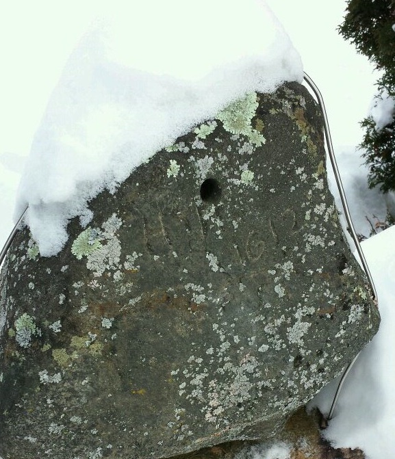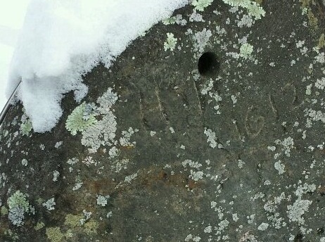
A stone inscribed with “HH 1612 CAPTIVE” found near Chalk River may hold the key to solving the 400 year mystery of what happened to the ill-fated explorer Henry Hudson. (photo D.Pilgrim)
A new look at a 400 year old mystery.
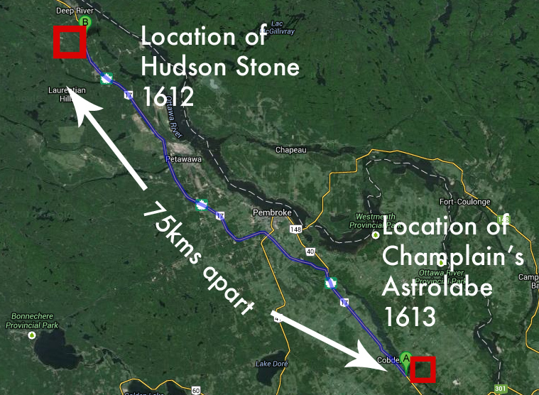
Only 75kms away from where Champlain apparently lost his astrolabe in 1613, in the town of Chalk River, ON, there is a rock with carved markings that read “HH Captive 1612”. Found in 1959 when a road worker re-paving Highway 17 came across it, this stone could help solve the mystery of what happened to the famous explorer Henry Hudson after his crew sent him adrift from his ship in a 1611 mutiny on James Bay. Does the carved “HH” represent “Henry Hudson”, held captive, a note left for someone to find and help him escape? Towns, bridges, rivers, bays, and retail stores are all named after him but he remains a mystery, a character lost in time with no final resting place as a landmark like the many places that display his name. The intrepid explorer Henry Hudson vanished into history, his legacy fading into the Canadian wilderness, but now there may be an answer.
HENRY HUDSON – Man of many places
On June 23, 1611, in an attempt to find the Northwest Passage, a mutiny aboard his ship Discovery left Henry Hudson adrift on what is now Hudson Bay, never to be heard from again. Before his mysterious disappearance this famous British explorer entered what is now New York state’s Hudson River in 1609, with the river being named after him in 1900. He founded Manhattan for the Dutch who he was employed by at the time. Entering New York City harbour, Hudson sailed 240 kilometres north on what the Native Americans called Muhheakantuck, now the Hudson River, exploring its shores all the way up to what is now Albany, NY.

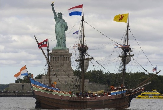
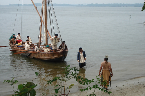
A replica of Henry Hudson’s 1609 ship “Half Moon” sails into New York City harbour during 2009 celebrations.
Also named after him is the huge saltwater bay, Hudson Bay, bordered by the provinces of Quebec, Ontario, Manitoba and Nunavut. The second-largest bay in the world, the bay connects to the Atlantic Ocean via the Hudson Strait, also named after him. The Hudson’s Bay Company, the oldest commercial corporation in North America (in continuous operation for over 340 years) and one of the oldest in the world, also carries the explorer’s name. A large toll bridge that connects Manhattan to the Bronx in New York City, the Henry Hudson Bridge was opened in 1936 near the site that Hudson first dropped anchor in 1609. The quaint tourist town of Hudson, NY is also named after Captain Hudson. Obviously this is someone of great importance to have so many prominent, historical landmarks named in his honour. But why has nobody ever tried to find out what happened to him?
A few books have been published about the disappearance of Henry Hudson, with many speculations made about his death. Some say he was murdered on his ship and cast overboard by his mutinous crew, others say he was sent off his ship with his son and 7 others in a small boat only to die floating across the icy arctic waters. Another story states that Hudson, his son and the 7 crew members loyal to him made it to shore and joined a group of area natives where they lived out the rest of their lives. Other legends have Hudson sailing back to Britain, or joining a native tribe, fathering children with a a female tribe member and living out his days happily as a family man in the Canadian wilderness.
A startling clue discovered only a two hour drive west of Ottawa may now help trace what really happened to Henry Hudson.
AN ICY JOURNEY

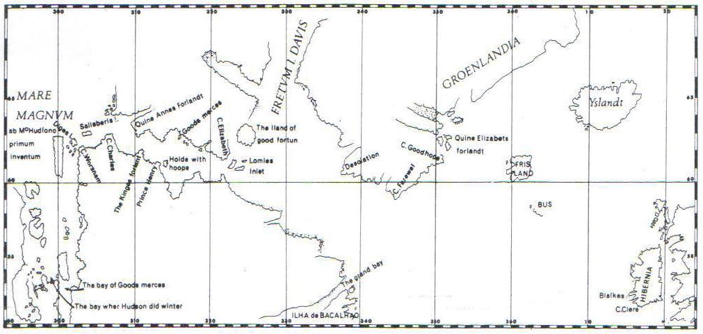
Henry Hudson’s map showing his 1610 arctic journey into Hudson’s Bay.
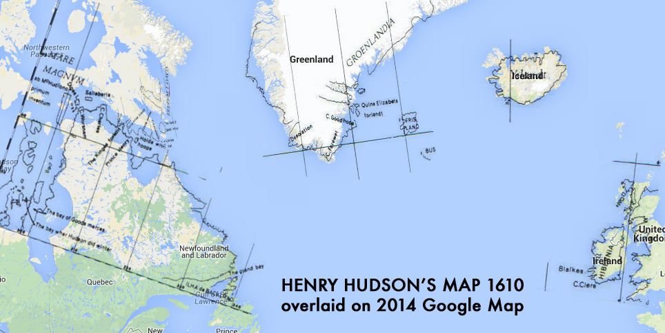
In hopes of finding the Northwest Passage to the Orient, and with the backing of the Virginia Company and the British East India Company under the English flag, Hudson took the helm of his new ship, the Discovery in April 1610. A 70 ton ship that was to sail across the North Atlantic with a crew of 22 men, including his teenage son. Departing England in April, Hudson arrived in Iceland on May 11 where he continued towards the south of Greenland rounding the southern tip in June. Hudson’s cartography skills were very accurate as his his map of the voyage (scale notwithstanding) compares well to a present day Google map of the area.

Hudson’s quite accurate 1610 map overlaid on a current Google map of the same areas.
Henry Hudson entered Hudson Bay in August 1610 and continued along the eastern coast of the bay entering what is now James Bay. In a desperate search for the legendary passage to the Orient, Hudson zigzagged his way through James Bay in hopes of discovering the fabled passage. The icy grasp of the Arctic was soon to take hold of the Discovery and its crew. On November 1, 1610, the Discovery sailed close to shore but by November 10 they were frozen in. With only enough supplies to last the winter, there was not enough to get them back to England.
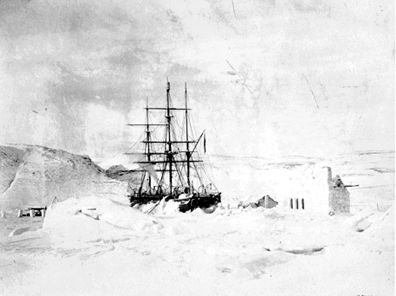
Hudson’s ship “Discovery” trapped in James Bay ice November 1610.
Hudson started rationing food which started a division between the crew that was the beginning of the end for Hudson. Hudson had a difficult time keeping order among his surly, sick, cold crew. With scurvy affecting many, members of the expedition began to die and resentment towards the determined Captain grew. A plan to mutiny was formed and when the winter ended and the ship was free from the winter ice, they began the voyage home. The voyage did not get far before the mutiny occurred. Hudson was ambushed, along with his son, the ship’s carpenter and those loyal to him. The ship’s shallop (a 20-30 foot boat with oars and a sail) was brought alongside the Discovery and the nine rope-bound men were loaded aboard the small boat with supplies, food, tools and blankets.

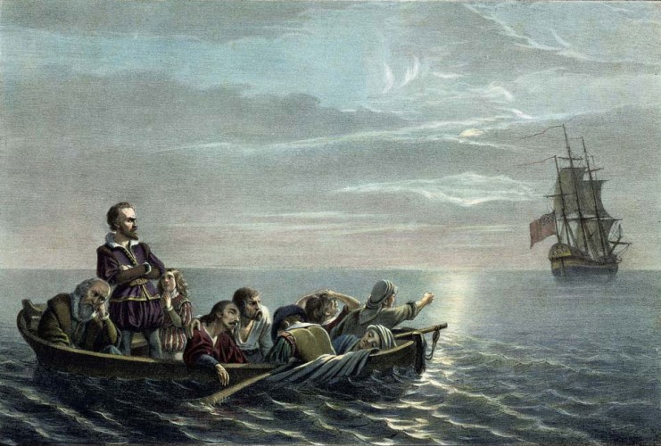
A depiction of the mutiny by Francis Davignon.
The Discovery’s turncoat crew released the shallop’s rope, setting Hudson and the 8 men adrift and the Discovery sailed away back to England. The famous explorer and his companions were never heard from again. No trace of Hudson or the 8 men have been ever been found to this day.
A THEORY
Now let’s look at some facts about the situation before we settle on the theory that he just died and vanished into the icy waters of James Bay like the history books tell us.
– Henry Hudson was an experienced sailor, explorer and cartographer who had successfully completed four arduous voyages to the New World.
– Hudson was determined, tough and not one to give up.
– Hudson had with him a carpenter aboard a boat equipped with oars and most likely a sail with supplies and equipment.
A typical early 1600’s shallop, equipped with sail and oars.
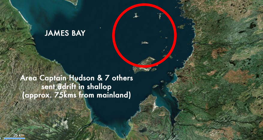
– Hudson and crew were at MOST 75kms from the shore of James Bay when they were released in the shallop from Discovery.

Area where and Hudson was sent adrift in June 1611.
– It was June 23 when he was set adrift. The summer was just beginning.
A recent book called “God’s Mercies: Rivalry, Betrayal and the Dream of Discovery”, has author Douglas Hunter describing how another famous explorer, Samuel De Champlain, found out that some Algonquins had enslaved an English youth. Champlain made his first trip up the Ottawa River in June 1613. Champlain travelled with Nicholas de Vignau, a man who had lived with the Algonquin people on the Upper Ottawa. Vignau told Champlain that he had visited the “Northern Sea,” or Hudson Bay/James Bay. Henry Hudson was there just TWO YEARS EARLIER. Champlain now was on the Ottawa River, hoping to visit this northern sea himself, the very sea that Hudson was trying to escape from.
Champlain’s astrolabe he allegedly dropped near Cobden, On in 1613 on his journey up the Ottawa River.
In fact, Champlain apparently dropped his astrolabe compass on the journey up the Ottawa River in an area that is now Cobden, ON. It was unearthed in 1867 by a farmer’s son and the Champlain astrolabe now rests in the Canadian Museum Of History. (Some question its authenticity)
Now this is where it gets interesting…

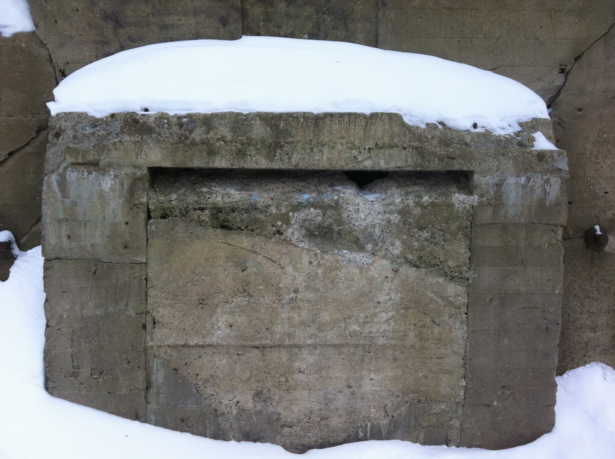
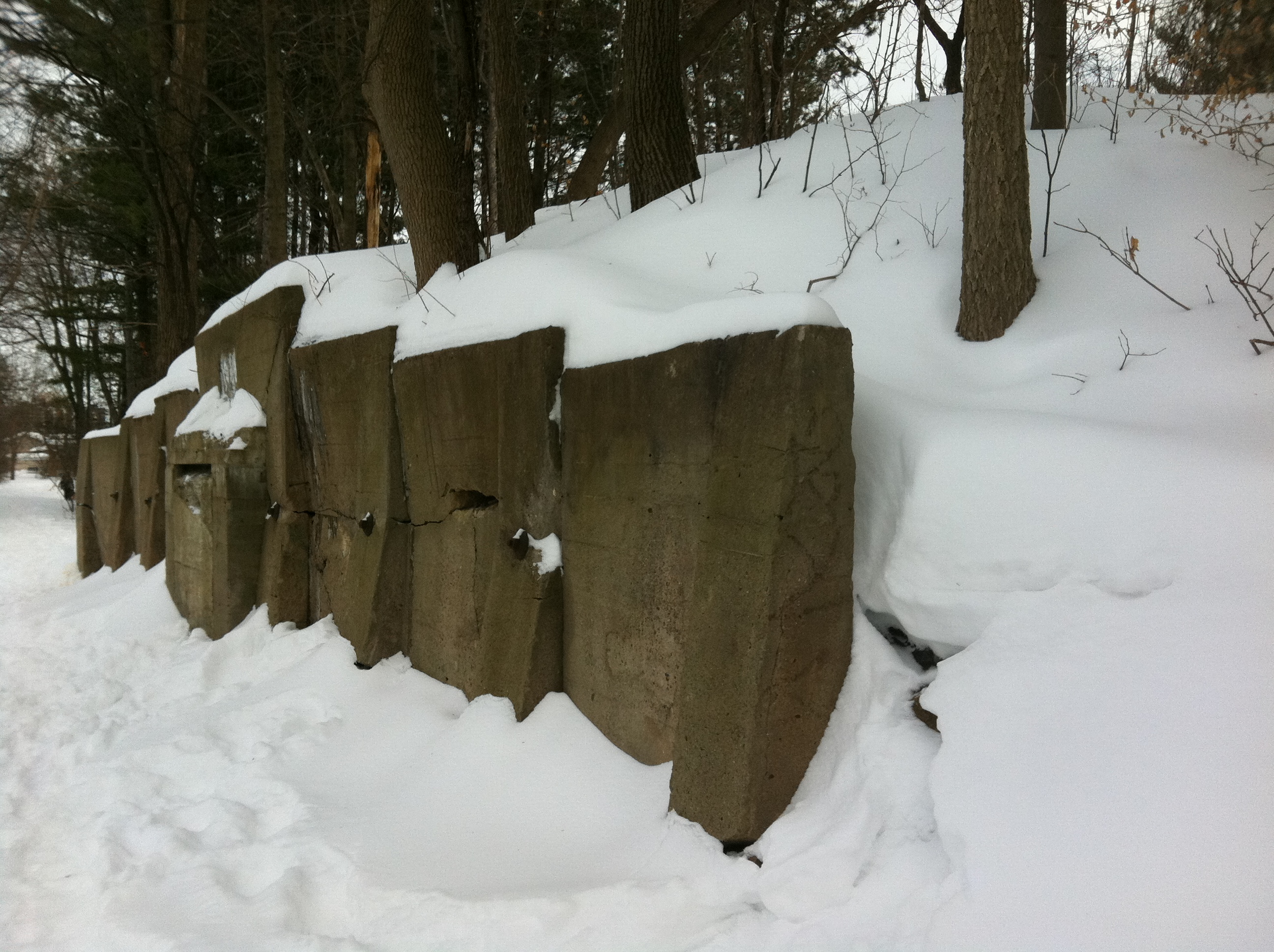
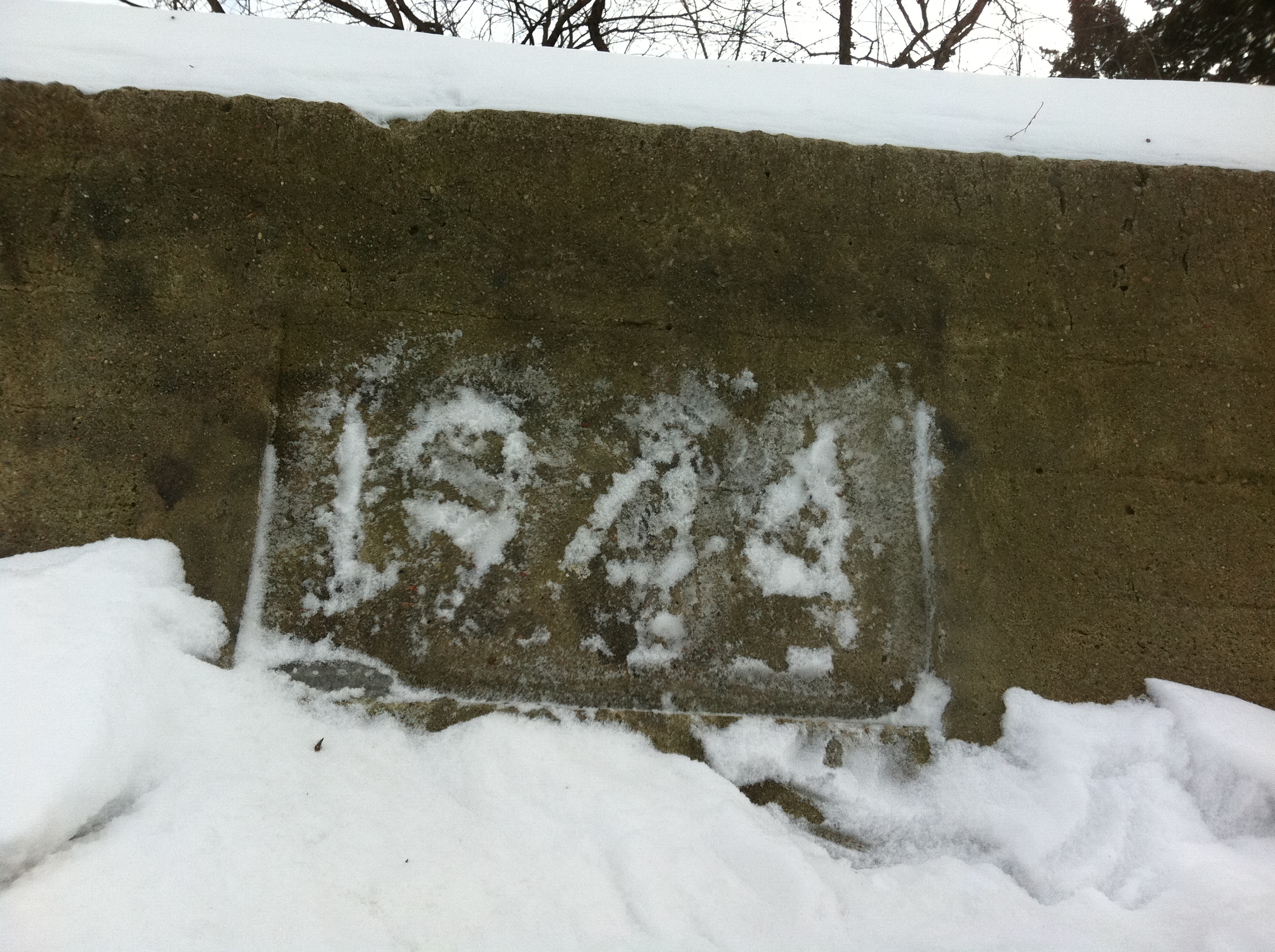
The Hudson Stone as photographed sitting in Chalk River on February 5th 2014. Inscribed with “HH 1612 CAPTIVE”. To date, no forensic studies have been done to verify the artifact. (Photo courtesy D.Pilgrim)
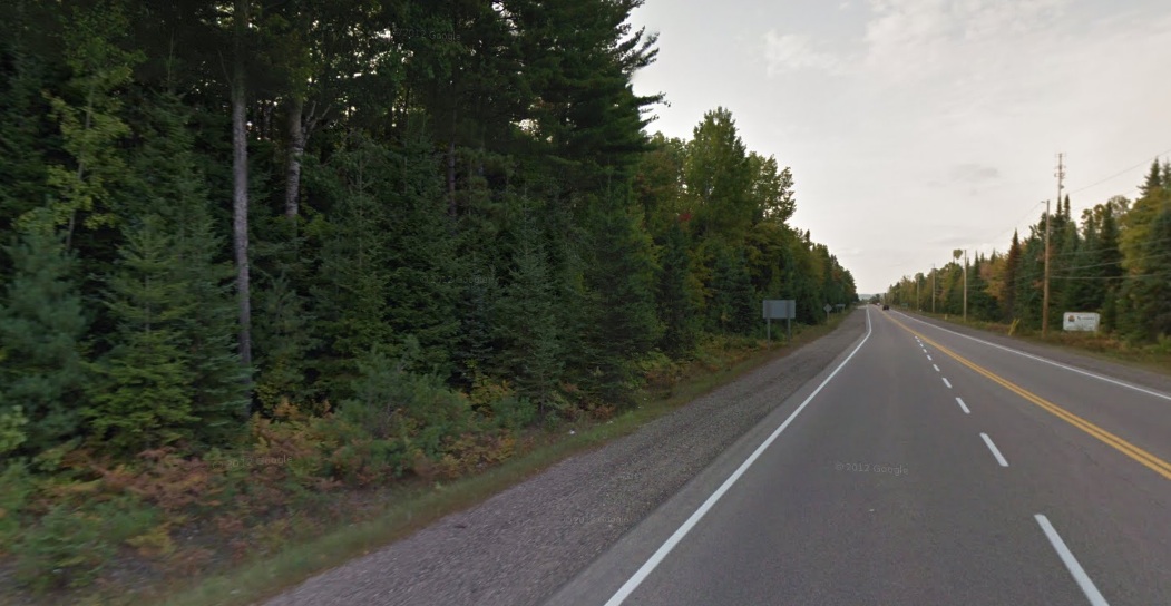
A stone was found by a construction worker while re-paving Highway 17 near Chalk River, ON in 1959 with unusual markings on it. Inscribed on the rock surface is “HH 1612 CAPTIVE”. For reasons unknown there has never been an official archaeological confirmation of the stone’s authenticity. Some say it was improbable Henry Hudson could have made it as far south as the Ottawa River. Also thought improbable was that Vikings made it to Canada 500 years before Columbus but now it is a proven fact they actually did. (L’Anse Aux Meadows, Newfoundland). Should we not study this rock that is supposedly insribed by Hudson and find out if it really is genuine and the solve a 400 year old mystery? Sitting in a small park in Chalk River, this rock could hold the key to what really happened after Hudson was sent adrift and end the mystery. Did Hudson and his men reach the shore of James Bay and journey south only to be captured by the Algonquins with Samuel DeChamplain en route to save them? The plot thickens, so let’s dig a little deeper…
THE ESCAPE
Now let’s take all those details mentioned above into consideration for a moment. What if Hudson and his men after being sent adrift pulled themselves together and rowed and/or sailed their shallop the 75kms to the shore of James Bay? A “shallop” is a 20-30 vessel equipped with oars and a sail. In fact, in 1608, Captain John Smith and fourteen English colonists set out from Jamestown in a 30-foot shallop to explore and map the Chesapeake Bay. They traveled over 1,700 miles in three months. Hudson and his crew were cast off from Discovery in an identical type of boat. They were released in their equipped shallop near the tip of James Bay, close to a number of rivers that enter the area, most notably the Harricana River. This 533km long river was first used by the Algonquins as a river route and its name originates from the Algonquin word Nanikana, meaning “the main way”. The Algonquins also use the name Inikana, meaning “river route”. A segment of the river was called Wajaha Sibi, which means “river to the bay”…James Bay.
Now let’s say Hudson makes his way to the Harricana River and continues south on it. It’s summer, they have some equipment and a carpenter to fashion shelters, hunt for food and survive during the warm months of summer. Completely feasible the shallop could make its way south along the Harricana River. Now it is a fact this river is also used by the Algonquins who use it as a “main way” and a “river to the bay” as previously mentioned.
What if Hudson and his men are captured by the Algonquins and taken south through the Harricana River system, over a 10km portage at Lac Mourier where the Harricana begins/ends and connects to Lac Simard where the Ottawa River begins/ends? Now on the Ottawa River, Hudson and whoever has survived along with him are traveling south with the Algonquins. Word spreads that “white men” (remember how Samuel De Champlain found out that some Algonquins had enslaved an English youth?) are captive and are making their way south along the Ottawa River.
.
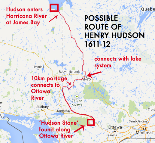
Hudson, now captive, a year after his being abandoned in the shallop in 1611, has arrived near Deep River in 1612 with the Algonquins. The timeline makes sense. Traveling the Harricana River from James Bay down the Ottawa River to Deep River would most likely take a few months putting Hudson into 1612. In a desperate attempt to signal any possible rescuers of his dire situation he carves into a rock “HH 1612 CAPTIVE”, which remained there until it was discovered in 1959.

Samuel Champlain is making his way north up the Ottawa River at about the same time, allegedly dropping his astrolabe only a mere 75kms south of the Hudson Stone in 1613. Did these two famous explorers unknowingly cross paths traveling in opposite directions along the Ottawa River? Hudson in Deep River, captive with the Algonquins in 1612, and Champlain there just a few months later in roughly the same place?

Approximate area where the Hudson Stone was recovered during re-paving of Highway 17 in 1959.
Perhaps by the time Champlain heard that the Algonquins had enslaved an English youth (most likely Hudson’s teenage son), Henry Hudson was dead, since Champlain was exploring the Ottawa River in 1613, and Hudson’s desperate carving was made a year earlier in 1612. Did the Algonquins kill him or did he die of illness after the carving was made in 1612 with only his son surviving out of the 9 men originally set adrift? Perhaps the remains of Henry Hudson lie buried somewhere between his carved message in Chalk River and Ottawa, narrowly missed by Champlain on his route in the other direction trying to find the northern sea where Hudson had originally started his fateful journey. Two famous explorers crossing paths, one trying to escape the cold, icy of waters of the arctic, the other trying to find it.
We may never know what really happened to Henry Hudson, his son or his loyal crew, and until we study the Hudson Stone in greater detail, we can only imagine how the final days played out for the explorer whose name adorns some of North America’s most notable landmarks.
SOURCES
http://en.wikipedia.org/wiki/Henry_Hudson
http://www.ianchadwick.com/hudson/hudson_05.htm
http://www.findingdulcinea.com/news/on-this-day/May-June-08/On-this-Day–Henry-Hudson-Set-Adrift-by-Mutineers.html
http://getawaytips.azcentral.com/landmarks-named-after-henry-hudson-3000.html
https://suite101.com/a/mysterious-disappearance-of-henry-hudson-a174487
http://books.google.ca/books?id=YGFLAQ-Cu6sC&pg=PA68&lpg=PA68&dq=henry+hudson+stone&source=bl&ots=TK8-_veGQM&sig=1Q81TfGClWN1yn8n9afB6AK0okE&hl=en&sa=X&ei=l7rqUpi9D_LNsQT-_oCwBQ&ved=0CGMQ6AEwCw#v=onepage&q=henry%20hudson%20stone&f=false
http://www.theglobeandmail.com/arts/hudson-at-bay/article1344733/
A 400-year-old shallop built and sailed again