Month: February 2018

Ruining Ottawa’s Oldest Ruins

Screen Shot 2018-02-26 at 7.53.06 PM

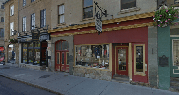
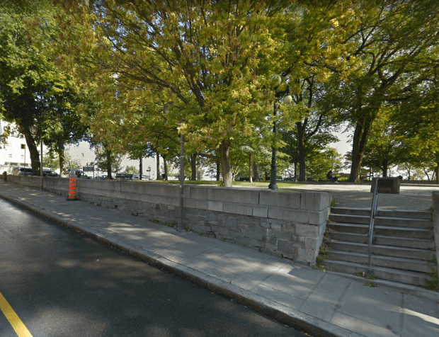
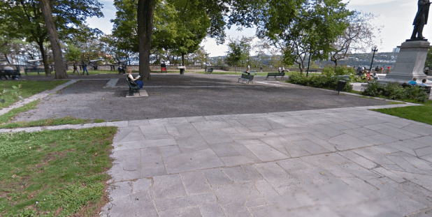
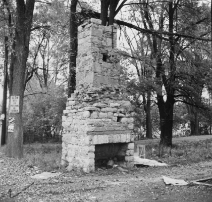
All that remains of Ottawa’s oldest structure. (Google Streetview)

Recently I was passenger in a car driving west along Riverside Drive and noticed something out my window as traffic dragged to a halt at the intersection of Riverside and Bank streets. There, at the side of the road was a wall of old stone. A faded plaque was mounted on it, but the light turned green and we sped away, the mysterious stone wall of unknown origin left behind. What was this puzzling old wall that lies obscurely at the side of a road passed by thousands of motorists each day? A quick Google Streetview visit reveals it is a “Frankensteined” wall hobbled together by the NCC made up of the ruins of a cabin built by one of Ottawa’s oldest settler’s to the region: Braddish Billings. These are the ruins of Ottawa’s oldest remaining structure.

BILLINGS BOOM

billings

A photo from the late 1800s of Braddish Billings cabin, the chimney of stone being what the wall currently at the side of the road is made from. (Image: “Bytown: the Early Days of Ottawa”)

After the nomadic indigenous people harmoniously lived in the region of the Nation’s Capital for centuries, the first to build a permanent structure here was an American by the name of Philomen Wright, who in 1800 built a cabin over in Gatineau (ruins are on NCC property, unmarked…that story here). Next to arise was a shanty trading post operated by Jehiel Collins near the Chaudiere Falls in 1809. Nothing remains of this cabin, property now owned by the NCC. In 1810 Ira Honeywell built a log cabin in Nepean. Nothing remains of this cabin either, just an NCC plaque hidden off Woodroffe Ave. near the Ottawa River that vaguely tells us of Honeywell’s cabin nearby.  Next to arrive was Braddish Billings who built his place in 1812 at what is now the intersection of Bank St. and Riverside Drive. A cabin was built by Billings along with some farm buildings. These would become the first permanent structures built in Ottawa after the Collins and Honeywell cabins.

lac-pa-125119

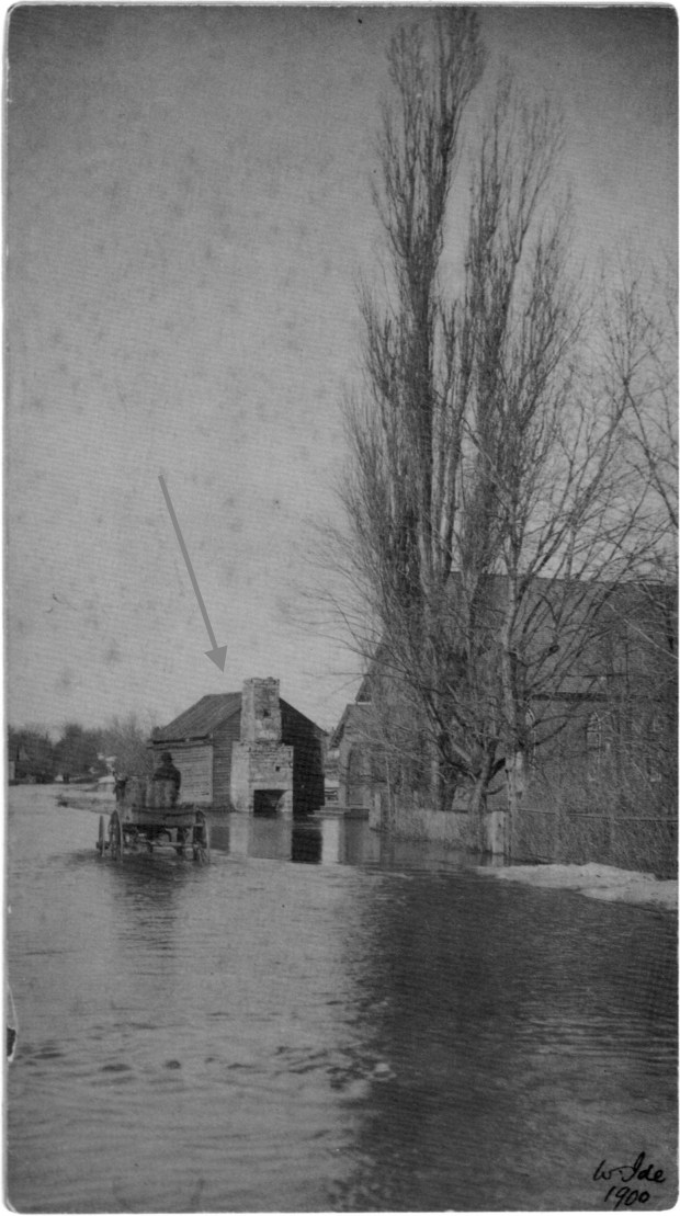
The early Billings cabin with stone chimney that was later made into a wall at the side of Riverside Dr. seen during a 1900 flood on the Rideau River. Methodist church beside it. (Image: Library and Archives Canada)

Billings made his cabin of round logs with no windows with an opening without a door. Billings was likely attracted to the riverfront site because of its close proximity to the Rideau River, its abundant timber, its creek, and its fertile soil. Along with building a sawmill, he began clearing the land and planted potatoes, hay, corn, and turnips. He also continued lumbering for Philemon Wright. His ventures proved successful and in 1829 he built a substantial estate on the hill above his original cabin, what we now know as the Billings Estate Museum, owned and operated by the City Of Ottawa.

Screen Shot 2018-02-26 at 8.19.01 PM

The location of the Methodist Church in 1912 and the Billings cabin that would have been beside it (Image: Ottawa Fire Insurance Plans, Carleton University)

With his new big estate house, the original cabin structures Billings built in 1812 fell into disrepair, neglected and falling to ruin. A Methodist church was constructed next to one of Billings cabins, a wooden structure, that one book says is Billings first house, with a stone chimney that remained on site until 1960 when the NCC demolished it, and the church, for a new Riverside Drive. Taking stones from this old cabin, they built a small wall out of it, which is what we now see at the side of the road.

Screen Shot 2018-02-26 at 7.57.30 PM

A 1928 aerial image shows the Methodist church and chimney ruins (circled in red) IMAGE: geoOttawa

The Ruins 

With such few remains of Ottawa’s first permanent structures, I find it odd the NCC would demolish our oldest structure to build a wall out of it. Why not keep the original chimney and build a replica cabin around it, instead of a sad wall? I guess in 1960 the history of Ottawa was not as important as we view it today, but still, it seems unfortunate the original chimney of Billings first structures that lasted so long was demolished and made into an obscure wall at the side of the road.

con063008_123471817

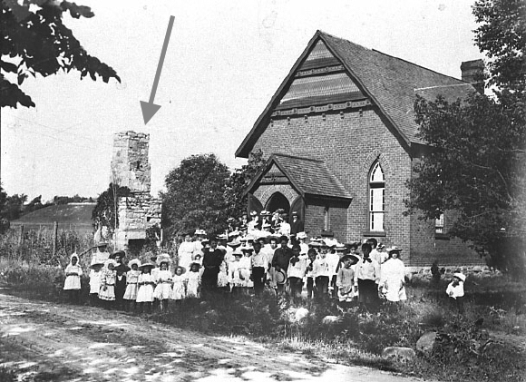
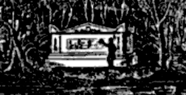
A photo from 1890 of the Methodist church shows the old 1814 ruins of the Billings cabin. (Photo: City of Ottawa)

con063033_123471793

The 1814 stone ruins of the chimney that was demolished in 1960 and made into the current side-of-the-road wall. (Image: City of Ottawa)

Screen Shot 2018-02-26 at 7.53.06 PM

Being the Nation’s Capital we have very few reminders of our inception, nothing remains of the Collins’ or Honeywell’s cabins.  Yet, at the side of the road near Riverside and Bank we have some pieced together stones from our past.

If you pass along Riverside heading west, (you can’t see it if you are heading east) or, if you are travelling on the path along the east bank of the river, take a moment to observe what remains of one of Ottawa’s oldest structures.


Andrew King, February 2018 


SOURCES

Library and Archives Canada

“Bytown” The Early Days of Ottawa, Nick and Helma Mika, Mika Publishing Co. 1982

https://www.oldottawasouth.ca/stories/item/3842-billings-estate-commemorative-wall


NEW! The ShadeTree Files: A podcast exploring Canada’s hidden history.

EPISODE 1: “The White Bird”

L'Oiseau_Blanc_on_test_flight

The disappearance of L’Oiseau Blanc is considered one of the great mysteries in the history of aviation. “The White Bird” was a French Levasseur PL.8 biplane that disappeared in 1927 during an attempt to make the first non-stop transatlantic flight between Paris and New York City. Less than two weeks later, Charles Lindbergh successfully made the New York–Paris journey and claimed the prize, flying the Spirit of St. Louis. Flown by French World War I aviation heroes, Charles Nungesser and François Coli, their biplane took off from Paris on May 8th 1927 and was last seen over Ireland, but never heard from again. In the 1980s new evidence surfaced that suggests that their aircraft probably reached Newfoundland. If the wreckage can be found it would alter history and oust Lindbergh as being the first to make the non-stop transatlantic journey.

Click on the  AUDIO FILE  “play” button below to listen.

shadetree

The Search For Champlain’s Lost Tomb

Samuel deChamplain is missing. He has been for almost 400 years. No one seems to know where the legendary explorer is. The whereabouts of such a prominent historical figure should surely be recorded and marked by archeologists and historians. Yet the famous explorer and the father of New France is no where to be found. His remains are lost somewhere in Quebec City, continuing to elude discovery for centuries.

Screen Shot 2018-01-30 at 9.44.40 PM

A sketch in an 1876 book entry describing Champlain’s tomb.

Recently I came across a book from 1876 that describes his tomb being discovered in 1850 but then lost again to history. Intrigued by this mystery, I studied old books, maps and other clues that show the great explorer could be subterraneanly buried in in the basement of a Subway restaurant, or more likely, hidden underneath a nearby city park. But hold the hot peppers, let’s go to Quebec City to see if this could be true.

THE QUEST BEGINS

original.298

Samuel Champlain. French navigator, cartographer, draftsman, soldier, geographer, ethnologist, diplomat, and chronicler. He made 20+ trips across the Atlantic and founded New France and Quebec City in 1608. Probably the most important figure in Canadian history yet no one seems to know what happened to him after he died in Quebec City on Christmas Day, 1635. Being the “Father of New France” and having explored hundreds of miles of North America, there are countless places, streets, and structures that bear his name and monuments built to commemorate the famous adventurer. However, no monument exists to mark the location of Champlain’s final resting place. I find this extremely odd, and had no idea he was missing until I went on a  vacation to Quebec City and jokingly asked our tour guide where Mr. Champlain was so I could say hello. The tour guide calmly, but seriously replied, “We have no idea where he is…maybe you can find him.” And so my quest began to find what happened to our most famous and intrepid explorer who seems lost in time.

MAPS

Champlain1640-marked

This map of Quebec City from 1660 clearly has a “Chapelle Champlain” labeled on it.

As with all great adventures, gathering many maps can help visualize the subject being studied. They are precious resources that lay out many details at the the time of their creation. Records of 1600s Quebec City are scant at best, but I did manage to find a map of the city drawn in 1640, only five years after Chaplain’s death. This would be a good starting point. Other maps were collected to cross reference information with current Google Maps.

Upon closer examination of the 1640 map there is an intriguing area marked “Chapelle Champlain” beside a cathedral called “Notre-Dame-de-Recouvrance”. This is where, according to records of the time, that Champlain was laid to rest after his death while a separate tomb was being constructed to honour his remains. But that cathedral and the chapel were destroyed by fire later in 1640, and construction began on a new tomb for Champlain. Did they rebuild and place Champlain in the same spot? That is not known, but using the 1640 maps we can superimpose its location on a current Google Map of the area, matching up key locations to properly align and sync the maps.

ghostmap1

Superimposing the 1660 map over a current Google Aerial Map.

ghostmap3

After alignment and ghosting the map over a current map, the Champlain Chapel, it seems the area in question lies under a street called Buade Street. In fact, there are plaques at the location that recognize Champlain was once there, yet no definitive proof of his remains has ever been found here. On this street there is a Chinese Restaurant, A Subway and souvenir shops.

Screen Shot 2018-01-30 at 8.43.42 PM

This is where the map and some plaques tell us that Champlain originally rested in his chapel while his final tomb was being constructed. (Google Streetview)

MAINmapmarked

Area in red outlines the area where Champlain’s first burial chamber may have been.

Screen Shot 2018-01-30 at 8.55.01 PM

In a book I found from 1876 called “Quebec Past and Present: A History of Quebec” by J.M. Lemoine, page 119 describes Champlain being moved around after the 1640 fire, so  his final resting place is likely elsewhere.

ANOTHER MAP

A later map, dated 1664, shows the rebuilt church and some curious unlabeled small buildings, of which one of them could be the newer tomb for Champlain. Also labeled is the “Fort Du Sauvages” , a fortified area used by the local indigenous Huron tribe, whom Champlain had been under friendly terms with. It would seem appropriate that the friend to both the settlers and the natives would be laid to rest near his close allies of the time, so those curious little buildings were marked.

Plan_Quebec_Bourdon_1664MARKED CROPPED

This map from 1664 shows the rebuilt cathedral and some curious little buildings around it that could be Champlain’s Tomb.

Ghosting over that aligned map with a current map, we can again see where that location is. The possible tomb lies on a hill near the Post Office, on a winding street that is as as old as the city itself. There is also a cemetery marked on the map, and it would also seem fitting that Champlain’s Tomb would be located in the only cemetery of the time.

HURONFORT1664marked

ghostall

Area in red show where Champlain’s original chapel was located and his possible second chapel. (Google Maps)

FURTHER RECORDS

In addition to the map evidence pointing to Champlain’s location, there are a few records in old books of where Champlain might be located. The most compelling record I found is an entry called “Champlain’s Tomb” by Dr. J.M. Harper from the Literary and Historical Society of Quebec from 1883.

screen-shot-2018-01-31-at-11-47-33-am.png

In this record, Harper explains that in the 1850s workmen were removing an old wall for some waterworks when they dug into a stone chamber. The “vault” as they called it contained a coffin within which were bones, a femur of which the workman who found it said was “very strong”. The workman made sketches of everything, and even made note of an inscription on the side of the vault that said “Samuel de Champlain”. When asked what he did with the bones, the workman responded by saying that “they had been examined and laid away, he knew not where”. The sketches, the bones and the chamber were then never heard from again.

Screen Shot 2018-01-31 at 11.50.15 AM

Screen Shot 2018-01-31 at 11.51.52 AM

The vault was either buried over, destroyed or both. So Champlain’s final resting place continues to be lost. Perhaps we can locate the records in city archives of this waterworks mentioned. In the meantime, let’s find out where this vault would have been located…

FINDING CHAMPLAIN

Using the maps and descriptions of these locations mentioned in the old records, we can visualize where they are. It seems the one possibility is under Buade Street and the Subway, but that seems unlikely as that was where he was first kept “in waiting” as they built the second, and final burial chamber.  Archeologists digging in this first chapel area did find stone ruins of the “Chapelle Champlain” but that was just a holding chamber, that later was destroyed by fire anyway. It’s the second vault we need to find, the one mentioned by the workers who discovered a tomb inscribed with Champlain’s name in the old original graveyard marked on the maps. This is where Champlain was laid to rest for centuries until 1850 when it seems he was accidentally discovered and subsequently lost again.

Screen Shot 2018-01-31 at 12.12.28 PM

Montmorency Park National Historic Site where I believe Champlain’s Tomb is.

Studying the maps and texts where Champlain might be hiding, there is currently a park called the Montmorency Park National Historic Site, once the original 1660s cemetery where Champlain’s Tomb originally stood.

screen-shot-2018-01-31-at-11-21-38-am.png

Screen Shot 2018-01-30 at 9.56.13 PM

A Post Office near where Champlain supposedly was buried. Is he here?

In 1688 the land was owned by Monseigneur de Saint-Vallier, who used the site for the first Episcopal Palace. Between 1693 and 1695, Saint-Vallier built a new palace but the project was ambitious and only half of the building was completed. During the siege of Québec in 1759 the building half destroyed.

Screen Shot 2018-02-05 at 9.18.06 PM

A plaque about the park, but no mention of the cemetery that was once here.

In 1831 the old building was sold to the government, whereupon a new building was constructed (this is when the waterworks men uncovered the tomb of Champlain) which later burned, was rebuilt, then burned again in 1883. The cursed lot was cleared out and it then became the park it is today. Yet, no mention at all on any plaques in this park that it was once an old cemetery that could contain the buried tomb of Champlain.

Screen Shot 2018-01-31 at 12.15.51 PM

The bottom edge of the original 1660 cemetery.

Screen Shot 2018-02-05 at 9.17.00 PM

This is where a cemetery once existed that probably contained Chaplain’s Tomb, but no mention of it is made.

Détail-de-la-carte-de-Jean-Baptiste-Franquelin-1688.-Bibliothèque-nationale-de-France.

The 1668 sketch showing the cemetery where the waterworks construction later occurred in 1850.

CONCLUSION

If we use the information provided by the old maps, the old records and the 1850 supposed discovery of Champlain’s tomb, it seems that all this time his lost chamber has been hidden underneath a park. The waterworks that are mentioned seemed to still be in place, as manholes and drainage grates show, but who knows when those were installed, and if they are indeed the original 1850s waterworks mentioned.

Screen Shot 2018-02-05 at 9.38.16 PM

Drainage grates in the park.

Screen Shot 2018-02-05 at 9.20.07 PM

Manhole cover in the park.

Perhaps Champlain was so revered and special, he was secretly hidden in a crypt we’ll never find.

It seems a shame that there has been no recent effort to locate the final resting place of one of this country’s greatest explorer’s, mapmakers and founders. His physical remains may be lost forever, but if we looked more closely in this park with GPR (ground penetrating radar) and other modern technology, maybe at least we would be able to finally mark the spot where he did rest, hidden for centuries, quietly overlooking the very city he founded 400 years ago.

Andrew King, February, 2018 

SOURCES

Google Maps

Engraving from Jean-Baptiste Franquelin, 1668

Click to access NS_19_CHAMPLAINS20TOMB.pdf

“Quebec Past and Present: A History of Quebec” by J.M. Lemoine

BING MAPS

Morrin Cultural Centre