Month: March 2016

OPERATION PLOUGH: Top secret vehicle designed in Ottawa to take on Nazis

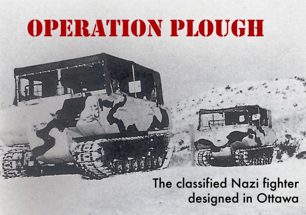
Ottawa has been home to a number of secret projects throughout history, from bat-like flying wings developed at the National Research Council to the world’s first UFO monitoring station, this city is no stranger to strange projects. At the height of World War 2, the Nation’s Capital was home to National Research Council classified development programs, some we may never hear about again. These classified programs included the development of atomic energy, radar technology and the lesser known development of a classified top secret vehicle to take down snow bound Nazis. Part of an elaborate plan dubbed “OPERATION PLOUGH”, Ottawa staff designed a snow vehicle that would see service in the US Armed Forces, but is rarely acknowledged as such. Here is the story of Ottawa’s top secret WW2 program to develop what is known as the WEASEL.

image

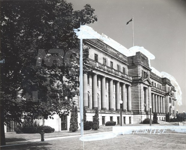
The Sussex Drive National Research Building where secret WW2 projects were developed. (photo: NRC)

During World War 2 the chief industrial threat was the creation of heavy water used in the German atomic weapon research at Rjukan in Norway. In March 1942 an eccentric British inventor by the name of Geoffrey Pyke proposed an idea called Project Plough to Lord Louis Mountbatten, Chief of Combined Operations Headquarters in England. This idea would see Allied commandos be parachuted into Norwegian mountains and establish a base on glaciers for commando attacks against the German army stationed there. These troops would be equipped with a radical new snow vehicle to disarm the Nazis and prevent Hitler from further developing nuclear capabilities. The special forces would require a snow vehicle that would be light enough to be carried in aircraft and dropped by parachute and be durable powerful and able to climb through all types of snow.

6020 M29 Weasel 02

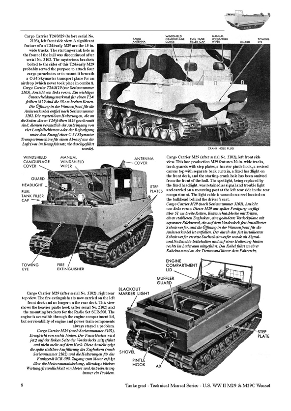
The Ottawa designed WEASEL, as produced by Studebaker in WW2.

The British realized they did not have the industry or capacity to produce a snow vehicle and called upon their US counterparts to devise this special snow vehicle. They in turn decided to call upon another ally with much experience with snow and cold: Canada.

The newly formed National Research Council in Ottawa was commissioned to work on this ambitious project due to their recent research on ski and snow science. Also of value to this special project was an employee of Ottawa’s NRC, George Klein who had developed the special ski science that focused on the interaction of snow and ice with certain materials.

Devbdepos

The classified vehicle developed in Ottawa was to be used by the infamous Devil’s Brigade (1968 film poster)

This top secret snow vehicle project was thus headed by Klein and the NRC in Ottawa for Operation Plough, headed by a crack commando team the “Devil’s Brigade” which comprised of elite Canadian and US personnel.  Klein and his Ottawa team would develop a secret snow vehicle called the WEASEL.

klein-klein_8

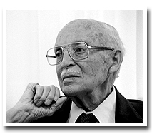
George Klein, who developed the WEASEL and would later aid in the development of the Canada Arm for NASA’s space shuttle.

Originally  called code name PLOUGH, the vehicle was developed in Ottawa under the guidance of Mr. Klein, an inventor who would later develop the CanadaArm for NASA’s Space Shuttle, the electric wheelchair and the Canadian CANDU nuclear reactor. In June of 1942 Mr. Pyke from Great Britain came to Ottawa and both he and Klein poured over design ideas at the Chateau Laurier for this new secret snow vehicle. Klein got to work immediately and the vehicle was developed at the NRC labs on Sussex Drive in Ottawa while the Americans put together an operational training force in Montana to train in snow conditions.

Chateau_Laurier_2

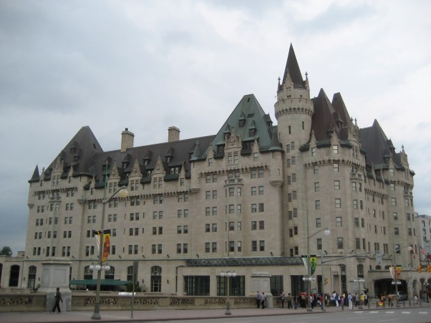
Klein and Pyke drew up plans for the classified snow vehicle at the Chateau Laurier in 1942. (photo:Wikipedia)

Canadians were already ahead of the game having their 1st Canadian Special Service Battalion in operation before merging with this new American task force dubbed the Devil’s Brigade. The newly formed  commando unit would require a unique WEASEL vehicle for Operation Plough in the winter of 1942-43 which gave the NRC less than 12 months to come up with a working prototype. Kevin delivered a prototype model from the Ottawa NRC research labs and the US military contracted the Studebaker Corporation to manufacture the vehicle in the numbers needed for Operation Plough. Studebaker used a Model 6-170 Champion engine, a 6 cylinder 169.6 cu in (2,779 cc) cubic inch 4-stroke engine running on 72 octane gasoline delivering 70 bhp at 3,600 rpm.

Screen Shot 2016-03-29 at 8.06.09 PM

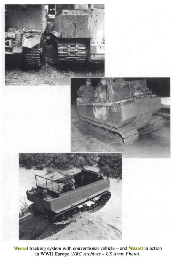
Klein’s Ottawa design would have full tracks of rubber instead of the usual half tracks with skis and the use of all rubber wheels and rubber faced sprockets so ice and snow would not jam the mechanisms during cold operations. The Studebaker engineers went with an all metal track against Kein’s wishes and so he developed his own rubber track at the Rubber Labs here in Ottawa. After the prototype WEASELS underwent tests in the Alberta snow, the metal tracks and components iced up and it was realized that Klein’s rubber idea was needed.

cc47Studebakerad-or

US automaker Studebaker manufactured the Ottawa-born WEASEL.

Studebaker then produced 15,000 of the Ottawa born Weasels, but Operation Plough in Norway was cancelled and the unique vehicle was used instead in Normandy invasion, the swamps of the Pacific Theatre and after the war in both Arctic and Antarctic explorations where its uniquely Canadian design abilities to deal with snow and ice were put to good and reliable use.

id_m29_3_full

The WEASEL in its element carrying WW2 troops through snow.

The M29 Weasel was in service with the US Army but it is rarely attributed to being designed here in Ottawa. Perhaps for our 2017 celebrations we can have one drive down Sussex Drive in honour of the Ottawa ingenuity that has been kept modestly quiet behind Ottawa doors for so many years.

Sources

George J. Klein: The Great Inventor
By Richard I. Bourgeois-Doyle, National Research Council Canada, National Research Council Canada. Monograph Publishing Program. 2004


Ottawa’s first public timepiece is North America’s second-oldest sundial

TITLE

North America’s second oldest sundial and Ottawa’s first public timepiece sits largely unnoticed on a corner of Sussex Avenue.

This Sunday March 20th the Northern Hemisphere enters The Vernal (Spring) Equinox, an astronomical event in which the plane of the Earth’s equator passes through the centre of the Sun, which occurs twice a year, once in March and again in September. During this event, both day and night are of equal duration across the globe. Ancient cultures like the Mayans would celebrate the occasion by performing rights of fertility. The Norse would worship Eostre, the Norse goddess of fertility and new beginnings, symbolized by eggs and rabbits, traditional symbols of modern day Easter. In addition to these sun worshippers, Ottawa has its own ancient device that harnesses the sun…an old sundial.

At the corner of Bruyère and Sussex in downtown Ottawa there is an unassuming marking on a building that was constructed in 1851. It is the second oldest sundial on the continent (one from 1773 in Quebec City is the oldest). Ottawa’s unique vertical sundials were built by Father Jean-François Allard, who had come from France and assigned as Chaplain to the Mother House.

Screen Shot 2016-03-16 at 12.53.05 PM

Father Allard built what is now Ottawa’s first public timepiece in 1851. (photo R. T. Bailey & Sister Louise Sequin)

Besides being a spiritual advisor to the nuns, he was a professor of Geography, Geometry and Mathematics with a keen interest in astronomy and the movement of the sun. Allard got to work designing and building the sundials on the southwest corner of the building and completed them on March 29 1851. It became the first public timepiece in Ottawa and the first of its kind in Canada.

dialmarked

After 165 years in the sun, the dial still maintains the correct time as matched to a photo with accompanying time stamp.

The two dials, 7×8 feet on the west side and approximately 7×4 feet on the east side, use black painted iron “gnomons” that capture the shadow of the sun and mark the designated time carefully with Roman numerals. The western dial has hour lines from 10 AM to 7 PM and the eastern dial has hour lines from 7 AM to 3 PM. These dials predate the use of time zones and show local solar time and they have been giving the correct time since 1851.

Celebrating its 165th anniversary this March 29th, the modest timepiece sits quietly unnoticed in downtown Ottawa, continuing to correctly give the time to all citizens who pass by. I think it might be time to dial in some attention to this timepiece, giving it some “time in the sun” so to speak, a recognition it rightfully deserves as being North America’s second oldest sundial and the National Capital’s first public timepiece.

Andrew King, OttawaRewind.com, March 17, 2016

SOURCES

http://sundials.org

http://www.historicplaces.ca/en/rep-reg/place-lieu.aspx?id=15271

“Sisters of Charity of Ottawa Sundials” by R. T. Bailey & Sister Louise Seguin SCO, NASS, St. Louis, Aug 2008

Mystery Of The Buried Blade

The area of Constance Bay located twenty five kilometers north of downtown Ottawa is no stranger to dramatic historical events. Previously OttawaRewind.com uncovered archeological documents revealing an ancient settlement from 500BC on its sandy shores and more recently that it was the site of a gruesome Fur Trade battle in the 17th century. From ancient times when the Ottawa River was an aqua-highway conduit used to transport copper ore from mines on Lake Superior to the Atlantic Ocean to its more modern role as a colonial outpost, the shoreline of the Ottawa River is if full of history waiting to be uncovered. That being said, it was not unusual to be contacted by a reader in Constance Bay who had unearthed a rusty sword in her garden two years ago. After contacting the War Museum without answer and knowing the area is largely unrecognized for its historical importance, I grabbed my own gear and headed to Constance Bay in search for answers to this Mystery of the Buried Blade.

THE FIND

Kim and Steve Fagan of Constance Bay live a stone’s throw from the sandy beach edge of the Ottawa River, an area of significant historical action, much of it not known to the public who have been building homes and cottages along its shoreline. Two years ago while doing some gardening, Kim was shoveling a garden plot and hit something metallic. “We were digging out a garden in the front yard and we found it about 12 inches below the surface.” said Kim Fagan, who has kept the blade in her closet, unsure of what it was. Pulling out of the sandy soil a relic from another time, Fagan had no idea how or why a sword ended up in her garden. It was only after reading the article in OttawaRewind that she thought it might be something of historical importance.

FullSizeRender

The blade found buried in Kim and Steve Fagan’s front yard.

Driving the short distance to Constance Bay I examined the blade in person and noted details about its construction, noting that its shape seemed less like a sword but more like a knife blade. The hilt reminded me of old bayonets I had seen in museums. Asking Fagan to study the blade further I measured the sword to be about a half metre long with an obviously modified hilt where cloth had replaced either a leather or wooden handle that had long since disintegrated. The hilt had been broken on one side, and the blade had a curved, almost scimitar shape to it like sword blades of the Middle East.

IMG_7475

The hilt of the sword looked to be broken and once wrapped in cloth.

Comparing the photographs to various resource sites on weapon blades, it seemed more and more likely not to be a sword but rather some kind of bayonet. I narrowed my search down to antique bayonet websites that provided more of a match to the relic’s shape than any sword.

I contacted Derek Complin of bayonetsplus.com, and a member of The Society of American Bayonet Collectors for his thoughts on this buried blade. Complin, an avid collector and obvious expert on all things bayonet concurred the blade was that of a bayonet, more specifically “A British Pattern 1860 sword bayonet”. Complin explained that these were issued to troops in Canada to be used with the Snider Short Rifle. The buried blade had at one time been subjected to a shortening of its blade and “the removal of the muzzle ring, and the grips, which appear to have been replaced with a cloth binding.”

Complin speculates the buried bayonet was “sold out of service at some point, or perhaps left service along with a retired soldier, and was modified or adapted for less warlike use.”

Researching more about this idea of it being a bayonet, I found that the unearthed blade matches almost perfectly the size and shape of the British Victorian Volunteer P1860 Short Rifle/Snider Sword Bayonet just as Complin theorized. Using photos of the original and superimposing them overtop the rusted old blade, the match was undeniable perfect. It was a modified bayonet blade from the 1860’s, once paired to a Snider/Enfield short rifle first issued to Canadian forces in 1867. A shipment of 30,000 of these rifles arrived from Great Britain in August of that year.

comp1swordcompghost

comp2sword

The original 1860 yataghan sword bayonet compared to the buried blade shows an exact match. (top photo Derek Complin)

This bayonet was based on the North African and Middle Eastern Yataghan swords, with their distinctive curved blades. Why that odd shape was chosen is unclear but some think the curve ensured that the blade was out of the bullet trajectory when it was attached to the end of the rifle. The bayonet was only issued for the Snider SHORT rifle, which in turn, was issued only to Sergeant’s and higher ranking officers in the Canadian Militia of that time.

ShortSniderMark3

The Snider/Enfield Short rifle and the bayonet sword issued with it to the Canadian Militia in 1867. (photo britishmilitariaforums.yuku.com)

How the bayonet became buried in the sands of Constance Bay is open to conjecture, but a study of an 1880 map shows the land of the current Constance Bay village was once property belonging to the Canada Company. The Canada Company was a large private chartered British land development company, to aid in the colonization of Upper Canada. The Canada Company helped emigrants by providing safe ships, low fares, implements and tools, and inexpensive land. The company surveyed and subdivided crown land areas, built roads, mills, and schools and advertised it to buyers in Europe. The company then brought new settlers to these area by means of a boat, which the company also owned.

conbaycomp1mapconbaycamp2map

conbay1880closeupmarked

An 1880 map of the area shows the land that is now the village of Constance Bay was once owned by the Canada Company. (red dot is where blade was found)

Perhaps the buried bayonet was part of a settler’s tools in a new land, or maybe it was a lost relic of a military operation in that area that was forgotten and buried over time. The Fagans have no plans for the 150 year old weapon but said they’d be “happy to donate it to a museum if they want it.”

compghost

The possibilities of how a modified 19th century bayonet became buried on the Fagan’s property remains open to the imagination, but we can be sure that this was once a military bayonet yataghan sword used by a higher ranking member of the Canadian Militia. Perhaps it was modified and used as a tool for carving out a new life in the unsettled wilderness north of the newly formed Nation’s Capital, or part of some other more nefarious business. Whatever the case may be, the area of Constance Bay continues to provide significant relics of our past that lie buried in the sands of time.

Andrew King, OttawaRewind.com 2016

Special thanks to Kim & Steve Fagan of Constance Bay and Derek Complin who graciously offered their time and information for this post.

SOURCES

bayonetsplus.com

https://en.wikipedia.org/wiki/Canada_Company

https://en.wikipedia.org/wiki/Yatagan

http://britishmilitariaforums.yuku.com/topic/13496#.Vt3zLoRiNBy

Google Maps

McGill Digital Atlas Project.