Month: October 2016

The PLUM HOLLOW WITCH

South of Ottawa, just past Smiths Falls, there is a curious old log cabin for sale near a place called Plum Hollow. Recently restored from its decrepit state, this little Victorian era cabin now offered for sale was once home to a respected real-life witch, THE WITCH OF PLUM HOLLOW.

A WITCH’S TALE

In 1857 Queen Victoria chose Ottawa to be the capital of Canada and the parliament buildings on the west side of the canal were opened in 1865. When the Dominion of Canada was established in 1867,  Sir John A. MacDonald became our first prime minister. These two important parts of history, Ottawa being chosen as the capital, and Sir John A. MacDonald are mysteriously connected to the Witch of Plum Hollow.

40544784_1454054755

Elizabeth Barnes, better known as the “Witch Of Plum Hollow”

Jane Elizabeth Martin was born around 1794 in Cork Ireland, Ireland. Just under five feet tall, Elizabeth was the daughter of a Spanish gypsy and her father  a colonel in the British army. Being the seventh daughter of a seventh daughter, Elizabeth would later claim this was the reason behind her abilities using a mystical “sixth sense.”

Arranged to marry a British officer, Elizabeth was deeply in love with another man, a  forbidden relationship in her family’s eyes, so she and her lover fled to North America. Once on the continent, the two lovers were married and gave birth to a son, but their love was to be cut short with the untimely death of her husband. She would later re-marry a shoemaker, David Barnes in 1843 and move to the hamlet south of Smiths Falls called Sheldon’s Corners. Here the two would raise a number of children before the husband left her without reason in the 1850’s. Elizabeth Barnes was left with her children to raise and needed money. It was then that her mystic abilities came into play…

WITCH POWER

john_a_macdonald_ca-_1875

Canada’s first Prime Minister, Sir John A. MacDonald visited the witch. ( photo:Wikipedia)

Charging 25cents to tell one’s fortune, Elizabeth was soon nicknamed “Mother Barnes” and had crowds of followers coming to her door seeking their future. Based on her incredible reputation of being accurate in telling one’s days to come, she accumulated enough money to buy a small log cabin of her own near Plum Hollow and entertained hundreds of people from all walks of life from all parts of the continent who sought out Mother Barnes mystic abilities. Farmers, doctors, lawyers, police and anyone else upon entering the tiny cabin would go upstairs to a small room where the witch would be sitting at a table with some tea.

mlsphoto-1-aspx

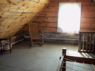
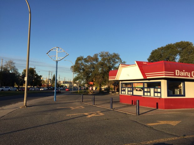
The upstairs room of the cabin where the witch would see the future. (Photo Re/Max Realty website)

Here the guest would have their fortune told in the tea leaves, a common Victorian practice of fortune telling. One of these customers was a young Attorney General by the name of John. He asked the “witch” as she was called, where the new capital of Canada would be located. Gazing through time she told John that the capital would be a town near a river called Bytown. She also told John that he would become the first Prime Minister in the capital city. John was John MacDonald, better known as Sir John A. MacDonald, and years later both prophecies would come true, Bytown would become the capital of Canada and he would indeed become prime minister.

CRIME SOLVER

Barnes clairvoyant abilities foretold that the body of Morgan Doxtader would be found and claimed it was the dead man’s cousin who murdered him.  That cousin was later convicted and hanged for the crime. The Witch Of Plum Hollow would also reveal the location of buried treasures, crimes of passion, locate lost personal items, and even reveal future loves. Her powers were always in demand, and she used them with great effect until she died in 1886 at the age of 92. Buried in an unmarked grave, the Witch of Plum Hollow would later receive a proper headstone put there by locals who revered their mystical witch.

6107013-l

A novel in 1892 was based on Mother Barnes, the witch south of Smiths Falls.

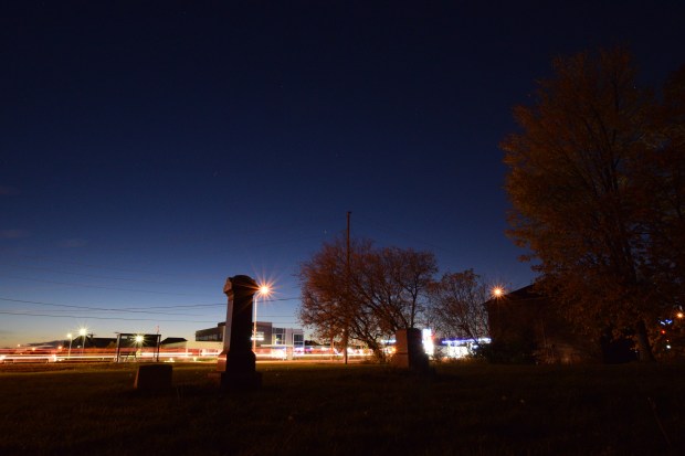
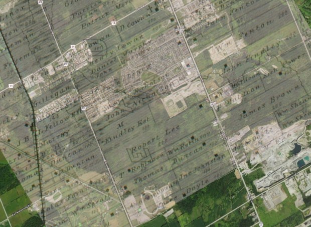
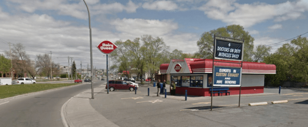
The original log cabin of Witch Barnes still remains on a gravel road called “Mother Barnes Road” south of Smiths Falls. Previously collapsing and in disrepair, the 19th century cabin has since been lovingly restored by new owners. It is now listed with Re/Max Realty for sale at $249,000. The link to the realtor website is here.

screen-shot-2016-10-05-at-8-46-05-pm

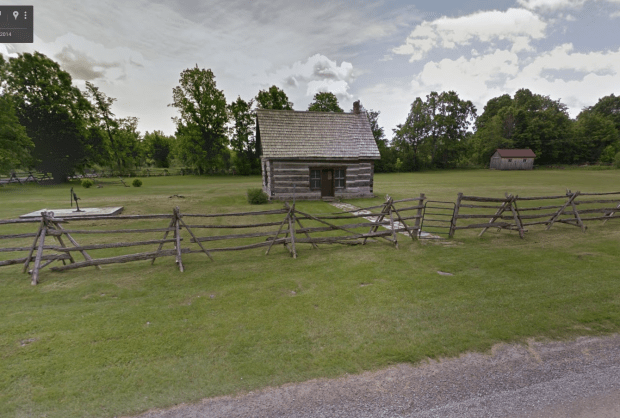
The original cabin of the Witch Of Plum Hollow still stands, recently restored. (Google Streetview)

It is unclear if the cabin’s new owners have sensed the presence of the old Witch of Plum Hollow in her old abode, but what is for sure, the fantastic tale of the clairvoyant witch will now live on into the future.

screen-shot-2016-10-28-at-4-01-40-pm

The realtor website listing for the Witch of Plum Hollow’s house now offered for sale.

Andrew King, October 2016

SOURCES

http://www.pinecone.on.ca/MAGAZINE/stories/ElizabethBarnes.html

http://www.insidebrockville.com/community-story/3961751-plum-hollow-s-witch-a-fascinating-character/

Google Maps

http://www.remaxriverview.com/329-MOTHERS-BARNES-YONGE-ON/443050115/KAREA


The Lost Tombstones On Bank Street

graves1

Google Streetview shows the lonely graves in an empty lot on Bank St. 

Bank Street is a busy road, constantly taking people into the heart of the city, or out of it. The multitude of cars that drive past Analdea Boulevard on south Bank each day probably take no notice of the trio of 19th century tombstones at the busy intersection. Yet, here an abandoned graveyard contains the rested souls of Goths.

INTERSECTION OF THE DEAD

graves2

Bank St. and Analdea Drive have three lonely tombstones at the intersection, top right. (GoogleMaps)

A grassy plot of land at the corner of Bank and Analdea looks quiet enough, save for the hundreds of cars that pass by it each day. Below its well cut grass are forgotten interred souls, one a 4 month old baby Goth, the others older Goths and Fentons. These are the last remaining souls of an abandoned 19th century graveyard that was moved to a new location sometime in the 1970s. Once a rural churchyard, the church building has since been demolished and its graveyard quietly removed…but not quite all of it.

map2marked

An 1880 maps shows a Methodist Church at the intersection. (McGill Digital Atlas)

In the latter part of the 1800s, a Methodist church was at the intersection that is now the gateway to the sprawling suburb of Findlay Creek, where a stretch of new homes surround a trio of old tombstones. Despite the suburban development, no houses seem to dare come close to the abandoned Goths. The old church served the outer settlements of Gloucester until sometime in the 1930s at which time the Methodist church closed.

map2-copy

Ghosting the old map on a current map shows the old church used to be at the same intersection.

With many of the 19th century locals being interred into the graveyard at the church, it still remained when purchased by the Women’s Institute in 1940, serving as a community centre. The community centre later moved elsewhere, and the former church was eventually demolished, yet the graveyard remained. Slowly, the graves were transferred to property near what is now the OLG Casino on Albion Road. For reasons unknown, not all the graves were moved, and three lonely tombstones remain at the Bank St. intersection.

dsc_0058

One grave marker is that of baby Herbert, son of May Ann and Robert Goth, aged only 4 months when he was buried. The buried baby Goth has inexplicably been separated from the grave of his parents, who lie at a separate graveyard down the road in Johnston Corners.  The other marker is that of  John Goth who died in 1897 at the age of 81 and with him lies his wife Hannah Goth who joined John in 1920 at the age of 96.

A third stone nearby marks the plot of the Fenton family, with six members of that family buried there. Ages of the dead here range from 23 years to 90.

dsc_0108

The City of Ottawa maintains the forgotten cemetery as development sprawls in all directions around the lonely graves. They seem out of place on a large tract of prime real estate surrounded by suburban homes. Perhaps the words on the Goth tombstone reveal part of the reason why they have not been disturbed…”NOT HERE HAS RISEN”

Andrew King, October 2016.

All photos unless otherwise noted by @OldManLoudWife


SOURCES

http://digital.library.mcgill.ca/countyatlas/searchmapframes.php

http://www.findlaycreek.ca

http://www.bytown.net/glou1834.htm

http://geneofun.on.ca/cems//ONCAR15264

Google Maps


Goodbye Merivale Dairy Queen Sign

img_0897

For decades the landmark Dairy Queen sign on the corner of Merivale and Clyde has greeted overheated customers in search of a cool treat at that location’s dairy bar. The sign  has now been removed, joining the many other lost classic signs of Ottawa’s streetscape.

screen-shot-2016-10-19-at-6-29-58-pm

Merivale’s classic Dairy Queen sign.

The sign was the second iteration of the Dairy Queen logo used from 1960 until 2001 when Dairy Queen executives decided “DQ” was a cooler moniker for their ice cream shops and started changing all the signs. Ottawa once had an even older sign on St. Laurent, a sign that dated from the 1950s but was removed in 2013 and demolished to make way for the new “DQ” makeover. That sign was famous and rare enough to make the official Wikipedia Dairy Queen page which unfortunately has not been updated to mention that the classic sign has since been trashed.

ottawa_neon_dairy_queen_sign

The classic 1950’s Dairy Queen sign that used to be on St. Laurent but was demolished to make room for a new corporate look. The photo is part of the Dairy Queen Wikipedia page.

screen-shot-2016-10-19-at-6-33-30-pm

The St. Laurent Dairy Queen after the makeover.

The classic red ellipse sign on Merivale has been in use since 1960, representing the swoop of soft serve ice cream with its pointy ends, but in 2007 the sign was “updated” with fancy new swooshy colours.

screen-shot-2016-10-19-at-7-15-04-pm

I guess it was only a matter of time before one of the last remaining classic 1960’s Dairy Queen signs would be removed to fit into the new corporate image. The location is a seasonal one, so there was no one there to ask about the sign when I visited. This has always been my favourite Dairy Queen, a shining beacon of an era all but lost in time.

img_0895

Both classic Dairy Queen signs have been removed, one from the pole and one from the store front. (Compare to Google Streetview below)

screen-shot-2016-10-19-at-6-30-42-pm

It seems a shame that we have to remove the classic signage of establishments that have adorned their businesses for so long. We have grown up with them, they are like a familiar old friend to greet us when we pass by. There is something comforting and welcoming about these classic old signs, a sentiment lost in corporate attempts to modernize.

To update a known and trusted industry brand by replacing old signs seems like a misguided attempt to fit into the modern streetscape. As the world progresses, I guess we must adjust, but why can’t we just leave the familiar old signs up and let us enjoy a bit of our diminishing city’s nostalgia.

Andrew King, 2016


The Secret Chemical Weapons Lab At Rideau Falls

cwl2c

An aerial photo of the Chemical Weapons Laboratory that used to be at Rideau Falls.

UPDATE: On October 24th 2016, one week after this article was originally posted, it was announced by the NCC that the site will now become location for Canada’s Centre for Geography and Exploration. The Centre is scheduled to open its doors in 2017 as a Confederation Pavilion during Canada’s 150th anniversary.

Being the Nation’s Capital, Ottawa has always been home to a number of government facilities working on classified projects. These “classified” government projects are developed in secrecy, with details about them not being revealed until years later, if at all. A scenic park beside Rideau Falls may seem like an unlikely spot where one of these projects occurred…but it did, and it was not just any project. It was a secret lab inside an old pulp and paper mill developing and testing chemical weapons.

A CHEMICAL WEAPONS LABORATORY 

cwl1a

The secret Chemical Weapons Lab at Rideau Falls that was once a pulp and paper mill. (Photo: Shirley’s Bay Review)

Allied forces during World War Two, including Canada, made preparations to wage both chemical and biological warfare. The use of chemical and biological weapons had already been experienced in the First World War with ghastly results. The threat of bio/chem weapons being used in WW2 was less of a concern due in part to the signing of the 1925 Geneva Protocol, a treaty prohibiting the use of chemical and biological weapons in international armed conflicts. Yet, here in Ottawa there was human experimentation involving volunteers at the wartime Chemical Weapons Laboratory in Ottawa to assess the effects of chemical agents as well as to develop protective measures.

A Chemical Weapons Laboratory.

In Ottawa.

What!? Where was this? you might ask…In some remote field miles south of the city in a secret facility?. No, rather it was a government building beside Rideau Falls that is now a scenic park owned by the NCC.

screen-shot-2016-10-17-at-7-53-01-pm

Current view of what used to be the Chemical Weapons Lab. (photo:Google)

THE PROGRAM

The year was 1941 and the National Research Council (NRC) was part of program to study the use of choking gases such as chlorine, and chloropicrin in addition to the hellish compounds of hydrogen cyanide and cyanogen chloride. Ottawa’s studies also included blistering weapons such as the infamous mustard gas. It is hard to believe but labs in Canada studied, tested, manufactured and stockpiled these bio/chem weapons during World War 2. Research was headed by the Directorate of Chemical Warfare and Smoke and conducted in Canadian university labs using NRC grant programs. These school labs included McGill, Toronto, Queen’s, Saskatchewan and Western.

screen-shot-2016-10-17-at-9-52-49-pm

Manufacturing of chemical and biological weapons at Rideau Falls labs. (from “A Brief History of the Defence Research Establishment”)

Ottawa had its own Chemical Weapons Laboratory working with the NRC at Rideau falls in a now demolished facility. Created in 1940, the Rideau Falls Chemical Weapons Lab, dubbed “CWL” was responsible for the production of flame thrower fuel and the manufacture of 1000 pounds of B1 dye used to detect mustard gas in addition to a number of other “classified chemical compounds”. By the end of the war CWL had produced 8 million gas masks, forty million canisters, and in Cornwall, produced barrels of deadly mustard gas.

The Ottawa labs worked on highly toxic but largely unknown chemical agents. Once a converted pulp and paper mill known as Edward Mills, the secret labs operated from 1940 until 1947 when operations were moved out of the Rideau Falls site to Shirley’s Bay. The labs were soon demolished after the move-out and were eventually made into Rideau Falls Park which is there today.

cwl2a

The John Street Labs, classified as “Chemical Weapons Laboratory, CWL” (photo: geoOttawa)

In addition to the study, testing and manufacture of bio/chem weapons and the associated gear to counteract them, the CWL labs at Rideau Falls also conducted experiments on volunteer subjects. Paid volunteers would be subjected to testing of chemical agents, with experimental counter measures being tested for their success. Subjects suffered blisters, and respiratory testing. In February 2004, the Ministers of National Defence and Veterans Affairs announced a recognition program to offer payments to these Canadian veterans who volunteered to participate in chemical-warfare experiments in Ottawa and elsewhere.

After the Second World War, the stockpiled chemical and biological weapons were taken aboard ships and unceremoniously dumped into the Atlantic Ocean, where barrels upon barrels of these nightmarish compounds decay on the ocean floor.

screen-shot-2016-10-17-at-7-56-00-pm

The current site of what was once the grim Chemical Weapons Lab. (photo: Google Streetview)

The site that was once a shrouded chemical and biological weapons facility is now nothing but a tranquil NCC owned property called “Rideau Falls Park”. Here the NCC built the now abandoned Canada and the World Pavilion in 2001,  which subsequently was shuttered in 2005. It was announced on October 24th 2016 by The National Capital Commission and the Royal Canadian Geographical Society that the site will now become Canada’s Centre for Geography and Exploration. “The Centre is scheduled to open its doors in 2017 as a Confederation Pavilion during Canada’s 150th anniversary.” There is no mention of the shrouded past of the site other than a quip on the NCC website that states it was “developed after the Second World War when the area was acquired by the federal government and cleared of industry.”

What a gas.

Andrew King, October 2016

SOURCES

Click to access CanadaandChemicalWarfare.pdf

Click to access p518800.pdf

http://www.theinternetdesignshop.com/WebImages/Shirleys%20Bay%201.pdf Shirley’s Bay Review

http://www.cheminst.ca/magazine/columns/then-and-now-5

https://legionmagazine.com/en/2016/05/chemistry-experiments/http://www.forces.gc.ca/en/news/article.page?doc=chemical-warfare-agent-testing-recognition-program/hnocfon0

Google Maps

http://www.ncc-ccn.gc.ca/property-management/what-we-manage/news/2016-10-24/50-sussex-drive-to-become-new-centre-geography-ex

“A Brief History of the Defence Research Establishment” published 2002


Ottawa’s Secret Sand Dunes

img_0698

Over 10,000 years ago a body of water covered the City Of Ottawa called The Champlain Sea, a deep sideline of the Atlantic Ocean. It occupied a depression created by a continental glacier, and then it drained away as the giant glacier that once covered the northern hemisphere disappeared and the earth rebounded back into shape.  Now its only remnants are the Ottawa and St. Lawrence Rivers. However, sand dunes were left to remind us of its former existence, sand dunes that exist hidden in the forests south of Ottawa off Slack Road. These dunes were a result of wind and water carrying sand left by the massive glacier into the sea by glacial rivers that once cut through through the glacial deposits. These sand dunes exist today, but are disappearing fast.

img_0697

Once humans began to traverse these ancient sand dunes, evidence has appeared that native people who needed wood and game inhabited the region, and archeological artifacts have been found in the area.  Hidden behind a facade of forest trees, the “sand zone” is recognized for its archaeological potential. I recently visited the site and found it to be a unique area worth visiting if you have the chance.

screen-shot-2016-10-11-at-11-16-01-am

This 1925 aerial view shows the once mighty extent of Ottawa’s Dune Sea. (photo from The Canadian Field Naturalist Journal June 2008)

Parking on a side road off Slack Road, we traversed up a small embankment to discover a flat plain of fine sand and dunes, stretching into the forest to the south. At one time this sand dune plain was massive, as a 1925 aerial photograph shows. In its current state it is just a fraction of its former self. The once mighty Dune Sea of Slack Road of about 3km in length has now been reduced to a few small areas of sand as the encroaching forest consumes this ancient Dune Region.

screen-shot-2016-10-11-at-11-10-07-am

Comparison photos showing the disappearing sand dune region south of Ottawa. (from Canadian Field Naturalists Journal June 2008)

The area is now part of the Pinhey Forest Reserve (National Capital Commission) and contains numerous trails where one can explore this ancient sand dune area. Housing developments, an industrial park and re-forestation efforts have all but concealed the former dunes, but the ground beneath is definitely a sandy experience. There seems to be remnants of some kind of archeological dig at the various dunes, with sifting equipment strewn about.

img_0733

The original sand dunes are now covered in forest growth, equally as magical. (photo Alison Fowler)

The forest that now covers the area is itself a unique feature as there are bizarre stick huts, carved stump monks and other oddities that give this hidden wonder a peculiar experience. Stick to the trails if you do go, and follow the trail maps, as it is very easy to become lost in the labyrinth among the secret sand dunes.

Andrew King, October 2016

SOURCES

http://journals.sfu.ca/cfn/index.php/cfn/article/viewFile/568/569

http://biodiversityconservancy.org/sand_dune.html