On a recent camping trip north of Kingston, Ontario, a lunch-time picnic at an unusual rocky structure revealed an intriguing inscription. While looking for a spot to set down our picnic blanket at a peaceful waterfall, an inscribed cross in granite was discovered.
Containing deep grooves and lichen growth, the cross symbol appeared to be quite weathered and did not seem like a recent addition to the stone. Who would inscribe such a symbol in this hidden place? Was this a surveying mark for the nearby 19th century Rideau Canal? A bored religious hiker from decades ago? The mark of a lost Samuel deChamplain in 1615, or is it the mark of an earlier explorer?
This is the mystery of the carved cross.
DISCOVERY
The Rideau Canal is a 200km waterway built between 1826 and 1832 that snakes through Eastern Ontario between Kingston and Ottawa. It is the oldest continuously operated canal system in North America, and we often enjoy traveling through its many locks and camping at the lock stations. This summer was no exception, and on a recent two-day campout on Whitefish Lake, we discovered this unusual inscribed cross.

“The Rideau Route” was a waterway route used by natives who wanted to travel from Lake Ontario to the Ottawa River. In 1783 a survey expedition initiated by the British government was led by a native guide along this ancient highway. From the Ottawa River they travelled south along the Rideau River to its source in the Rideau Lakes, then down through the lower Rideau lakes into the Gananoque River. From there it leads down to the St. Lawrence River and further to the Atlantic. Traveled for centuries before any Europeans arrived, the route was chosen by Lieutenant Colonel John By of the Royal Engineers who was given the arduous task of building a navigable waterway, with a minimum depth of 5 feet, from the Ottawa River to Kingston where the eastern end of Lake Ontario enters the St. Lawrence River.
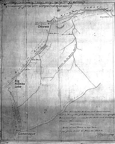
Original waterway as surveyed in 1783 from the St. Lawrence north to present day Ottawa. Image: Rideau-Info.com, “Communication with the St. Lawrence & Ottawa Rivers, by the Rivers Petite Nation and Rideau” copied from sketches by Lt. Gershom French 1783, by William Chewitt, August 26, 1794, Archives of Ontario, AO1336 (left panel).
The proximity of the carved cross to the Rideau Canal creates a suspicion that it was possibly inscribed by one of the thousands of labourers or tradesmen that were hired by independent contractors, with the rock work completed by French Canadians and Scottish stone masons. The unskilled labour was generally made up of Irish immigrants and French Canadians. Could one of them made the cross? It seems unlikely as the cross was carved on a very unusual rock feature that would have been hidden away from the labour camps.
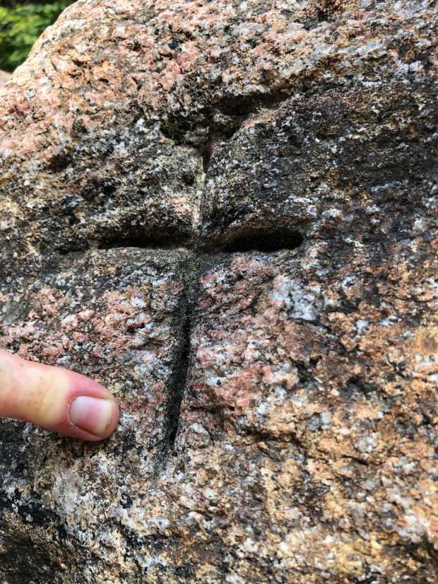
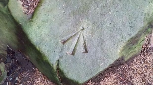
Situated on a granite rock facing an opening where a stream of descending water enters, the carved cross is about 15 feet up from ground level and would require a person with some level of skill to ascend to.

Detail of the inscribed cross showing weathering and lichen.
Facing the rising sun in the east, the cross is carved with deep grooves with exact precision to replicate the exact proportions of the Latin Christian cross.
Someone who knew those dimensions and proportions carved that cross. Approximately 10 inches in height, the cross is intentionally carved to be visible when at the cavern opening where the water enters into the cave below.
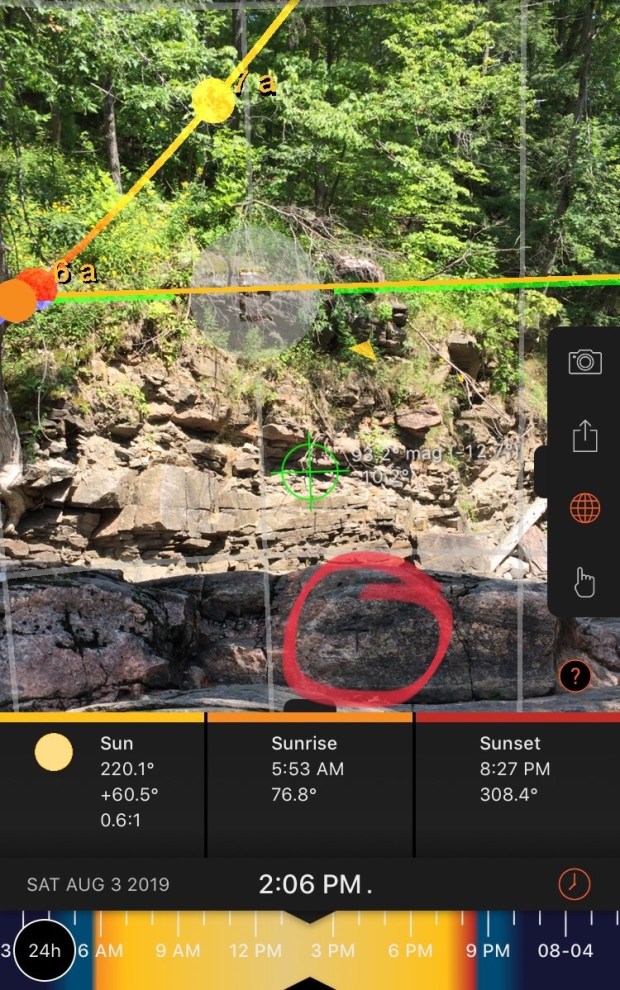
The carved cross is on a stone that faces the rising sun in the east.
POSSIBLE SUSPECTS
So who carved the cross? With dating methods to try and date the inscription not being available, we must look back at possible creators through history. The indigenous people are a possibility, but would they replicate a Christian Cross in exact proportions? The only other rock inscriptions by indigenous people are at the Peterborough Petroglyphs where the soft stone was carved using gneiss hammers to incise human figures, animals, and figures by the Algonkian or Iroquian speaking people between 900 and 1100 AD.
Was there a visitation to the area by pre-contact Christians who used the ancient waterway of the native population at the time? Legends of Irish monks like Saint Brendan that travelled to North America in 520AD, as well as Prince Madoc from Wales who apparently made it to North America in 1170AD. Other possible visitors are medieval Norse Christians who we know visited North America in 1000AD and in the Arctic region in 1200-1300.
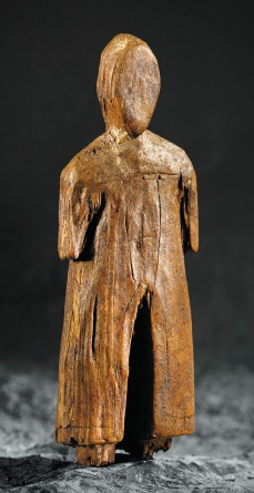
The robed carving dated to the 13th century with an etched cross found on Baffin Island (photo: historymuseum.ca)
In fact there is a wooden figure that was uncovered along with sword fragments, chain mail and tools during a 1970s archeological dig on both Baffin and Ellesmere Islands that shows a carved Christian cross on its chest. There is always the theory that Templar Knights ventured to North America and followed routes inland to create a new establishment. Did they follow the routes of the native people from the St. Lawrence up the waterway and leave their mark at this unusual location? Without being able to date the inscription it is hard to say who made the symbol of the cross.

Size relation of a watch with the carved cross.
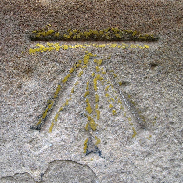
Other possibilities include a surveying mark left by the British Ordnance survey team while surveying the Rideau Canal. But further research and a note from the British Ordnance says that they did not, and never would have made that mark.
British Ordnance survey benchmark carved into rock. Images: Wikipedia
Was it just some random religious person taking the time to carve out an exact Christian cross for fun? It seems unlikely, as this was precisely carved using a tool of some precision.
Another contender is the famous explorer Samuel DeChamplain who was lost in the woods for a week in the fall of 1615 after his failed mission to destroy the Iroquois in what is now Syracuse. His exploits and the ensuing battle resulted in him being shot twice with arrows in the leg, forcing him and his party to retreat across Lake Ontario to a “large river” where they built cabins and stayed for a period of a month. Champlain pleaded to be returned to his settlement and as he recounts in his journal:
“after crossing from the island, the end of the lake, we entered a river some 12 leagues in length”. This I believe to be Cataraqui River, now part of the Rideau canal system.

Converting Champlain’s “French League” from his journal into modern kilometre measurement.
This entry most likely refers to crossing “from the island” which would be Wolfe Island, over to Kingston, On and into the Cataraqui River. When we apply Champlain’s “12 leagues in length” it calculates to be 42km up the Cataraqui River, placing Champlain up near Seeley’s Bay, ON. and Whitefish Lake. A This leaves the Cataraqui River as the most likely option and matches the “marshy” description of the river’s entrance in his journal.

Champlain’s group built two or three log cabins most likely on the shores of a lake, likely Whitefish Lake, where a great deer hunt was established using native hunting methods of building traps and deer capture enclosures. This “great deer hunt area” is marked on a map made by Champlain in 1632 that is marked “Lieu Ou il y a Forte Cerfs” which when translated means “place where there is strong deer”.

Champlain’s 1632 map mentions the area where the cross was found as a place with strong deer, as noted from his 1615 journey.
Champlain at this point on his adventure gets lost in the woods of which he transcribes into his journal in great detail. Having wandered off trying to capture an unusual bird he had spotted, Champlain was separated from his native companions and was lost in the woods North of Kingston for days. Spending the first night at the foot of a massive tree, Champlain trudged on and came to a pond where he killed some birds of which he ate to survive. In what he describes as being about 5-6 days lost and wandering the woods north of Kingston, which I think is in the vicinity of Jones Falls where he came across a stream that he followed to a small lake about 4km in length which would have been Whitefish Lake before the building of Rideau Canal in 1830 and the subsequent flooding of the land.
Champlain mentions hearing a great waterfall and being surrounded by mountains, of which were probably Jones Falls (the falls are long gone as they were dammed up for the canal project) and the mighty and nearby Rock Dunder mountain area respectively. There are no large mountains per say anywhere west of the Frontenac Axis geographical formation of which his terrain descriptions would match. It has to be here.


The only “mountains” north of Kingston where Champlain would have ventured are the mighty Dunders, at Morton, On on Whitefish Lake.
Following the river Champlain was finally re-united with his worried native companions who told Champlain that if had not returned, they would never again meet with the French in fear that they would think they had killed Champlain. It is something to contemplate that history could have been much different if Champlain remained lost in the woods and perished north of Kingston.

Did a lost Champlain thinking he would die in the wilderness leave a trail of bread crumbs in the form of carved crosses? It is unique and recognizable symbol of a European Frenchman at a very prominent location on the waterway. His accounts match the area where the cross was found almost exactly and this geological feature would sure be a known location on a travelled route. Further investigation into Champlain’s possible route would be necessary, but the carved cross could have been made by Champlain as he wandered the wilderness in 1615.
I contacted both Parks Canada and The Canadian Museum Of History about the inscription, but as of this posting, neither has responded.
Was it carved by a bored religious person at the falls or was it something more meaningful? Roaming Knights Templar on a journey through North America? The lost explorer Champlain leaving a trail of recognizable French Christian symbols of his whereabouts in 1615? Without further study of this inscribed cross hidden in the woods its origins will continue to pass through time, yet another piece of a puzzle lost in the margins of history.
Andrew King, August 2019
SOURCES:
Rideau-Info.com
The Voyages and Explorations of Samuel deChamplain, Journal by Champlain. c. 1616.