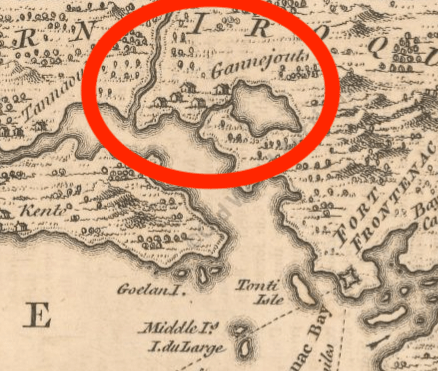
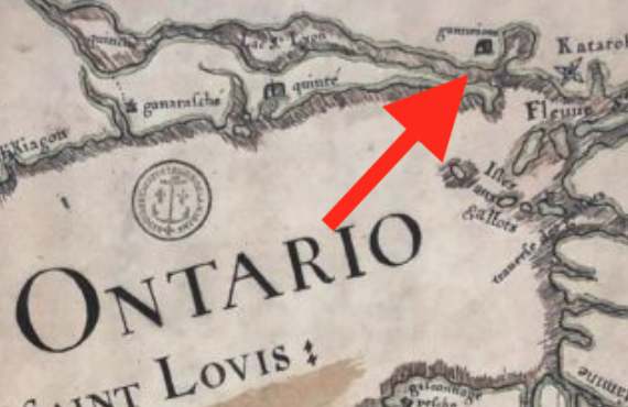
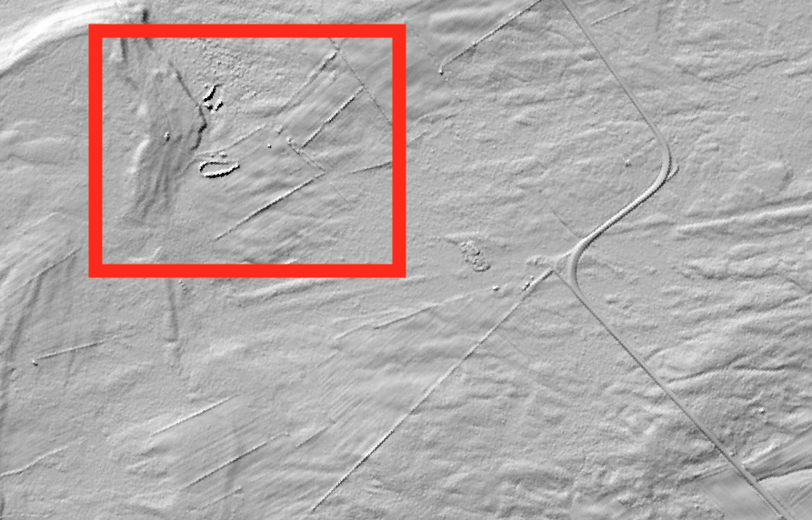
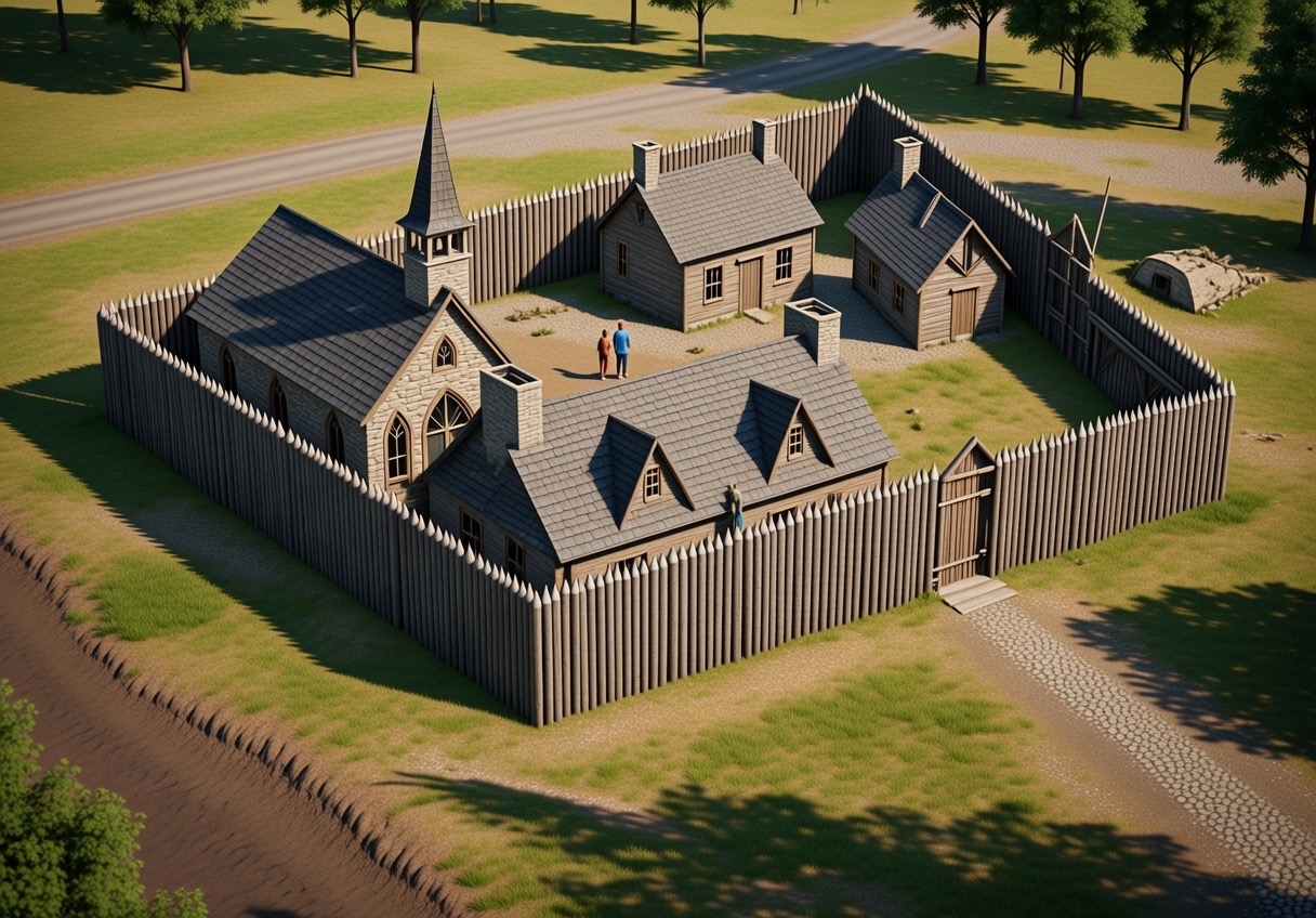
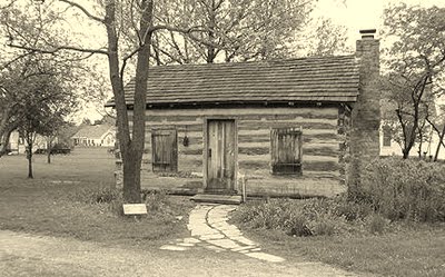
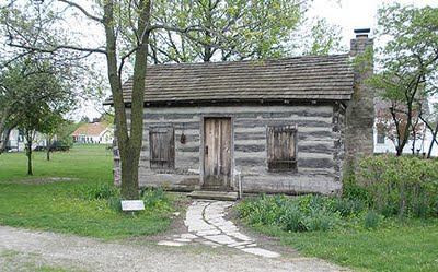
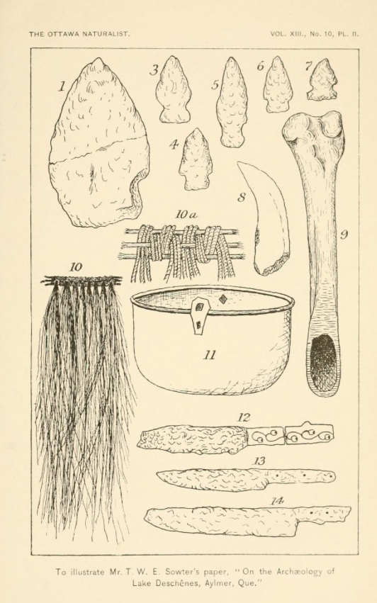
A map from 1733 that indicates a curious village called “Gonejou”
A recent study of an old map of the Great Lakes region revealed a curious detail that piqued my interest…a sketch of a village near Kingston called “Gonejou”. Having grown up in this area I had never heard of such a place and wondered if it was a case of mistaken geography and the map makers meant “Gananoque”.
Another map from 1733 also shows a village of “Gonejou”
However, further research revealed that there are more maps that show it and indeed there was such a village that existed in the 1600’s that apparently vanished without a trace. This is the search for the LOST VILLAGE OF GANNEIOUS.
BACKSTORY
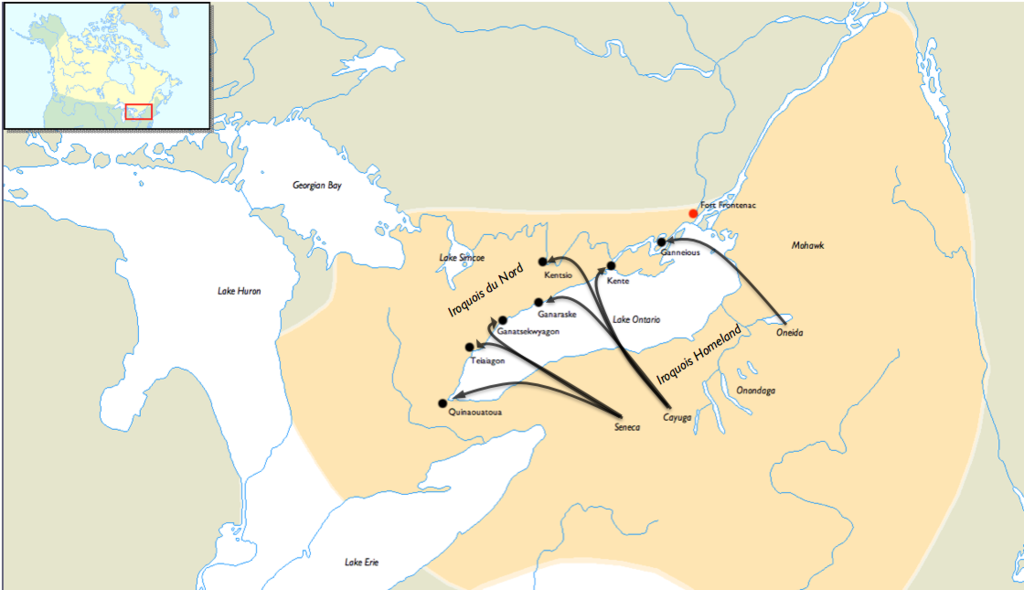
The map I was studying was from 1733 and it showed a host of unbeknownst-to-me villages with illustrations of buildings around Lake Ontario and the St.Lawrence River. These are places I had never heard of including the mysterious “Gonejou”…Kente, Kentsio, Ganaraske, Ganatsekwyagon, and Teiaiagon. It seems in the decade of 1660 AD various groups of Iroquois had established seven villages along the shores of Lake Ontario where trails led off into the interior to hunt and gather trade goods. These villages were “bases” set up by the Iroquois for the control the flow of furs from the north and west to their stronghold south, across Lake Ontario in what is now New York State.
A map showing the northward expansion of the Iroquois into the Ontario area.
The village in question, “Gonejou” was said to be a village created by the Oneida group that was located near the fertile and productive soils of the Hay Bay/Napanee area, but its exact location has never been determined. The other villages are known to be located at the following places:
Kente – on the Bay of Quinte near Carrying Place
Kentsio – on Rice Lake
Ganaraske – on the site of present day Port Hope
Ganatsekwyagon – at the mouth of the Rouge River
Teiaiagon – at the mouth of the Humber River
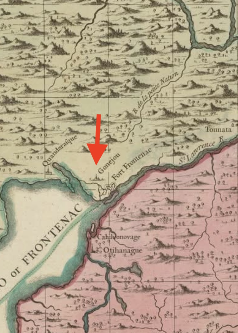
Gonejou as marked on the map is on earlier maps and marked as “Ganneious”, also spelled “Ganneous”. The name is most likely a likely misprint for the French “Gannejout(s)”, that means “Oneida”.
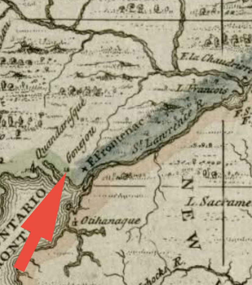
When the Oneida village was created in the 1660s, it was soon joined by new neighbours, the French, in 1673 when they built Fort Frontenac, which was located in modern day Kingston, Ontario about 40 kilometres east of said village Ganneious.
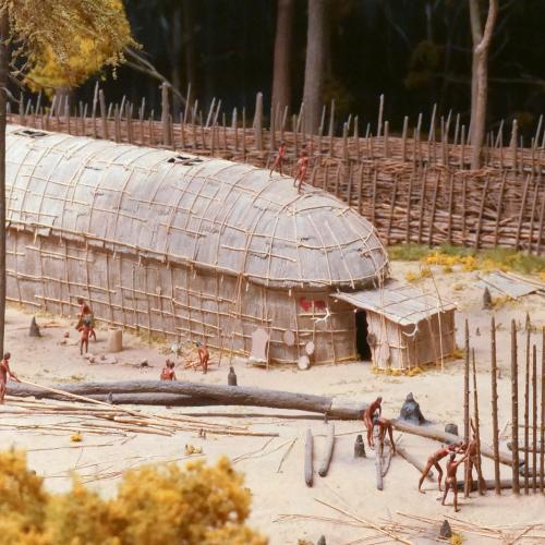
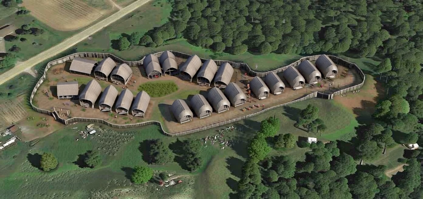
A scale model of how an Iroquois village may have looked.
Fort Frontenac influenced Ganneious when French missionaries made several attempts to encourage the population in Ganneious to resettle closer to the Fort, in order to Christianize, Europeanize and encourage them to learn trades and farm.
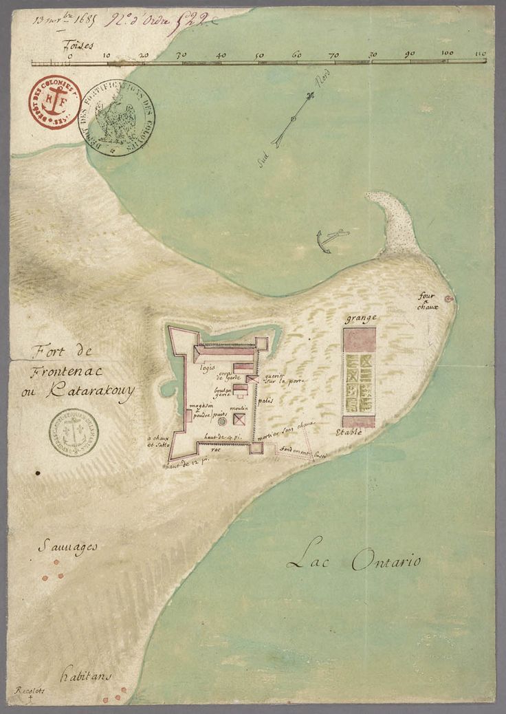
An early French map showing Fort Frontenac and the cabins (bottom left) for the native Iroquois or “Sauvages”
In 1675, René-Robert Cavelier, Sieur de La Salle, and Father Louis Hennepin decided to embark on a journey from Fort Frontenac to Ganneious on a mission to convince the villagers to relocate closer to Fort Frontenac.
Hennepin actually wrote an account of this mission and journey in “A New Discovery of a Vast Country in America”:
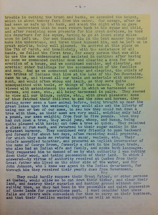
“While the Brink of the Lake was frozen, I walk’d upon the Ice to an Iroquese village call’d Ganneouse, near to Kente, about nine Leagues off the fort, in company of Sieur de la Salle above-mention’d. These Savages presented us with the Flesh of Elks and Porcupines, which we fed upon. After having discours’d them some time, we return’d, bringing with us a considerable number of the Natives, in order to form a little Village of about Forty Cottages to be inhabited by them, lying betwixt the Fort and our House of Mission.”
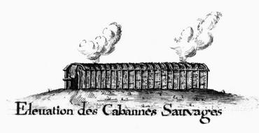
The Iroquois cabins at Fort Frontenac.
You can see on old maps of Fort Frontenac the cottages described for the moved Ganneious villagers. It would be about 12 years later when things turned sour and the new Governor of New France, Jacques-René de Brisay, Marquis de Denonville, came on the scene who was under order from France’s King Louis XIV who had instructed Denonville to “remove the fear of the Iroquois menace by humbling their pride.” Denonville recognized that the security of New France depended on stopping the Iroquois aggression and had soldiers brought in for this purpose. So in 1687, he led a punitive mission against the Iroquois that destroyed four of their villages, including Ganneious.
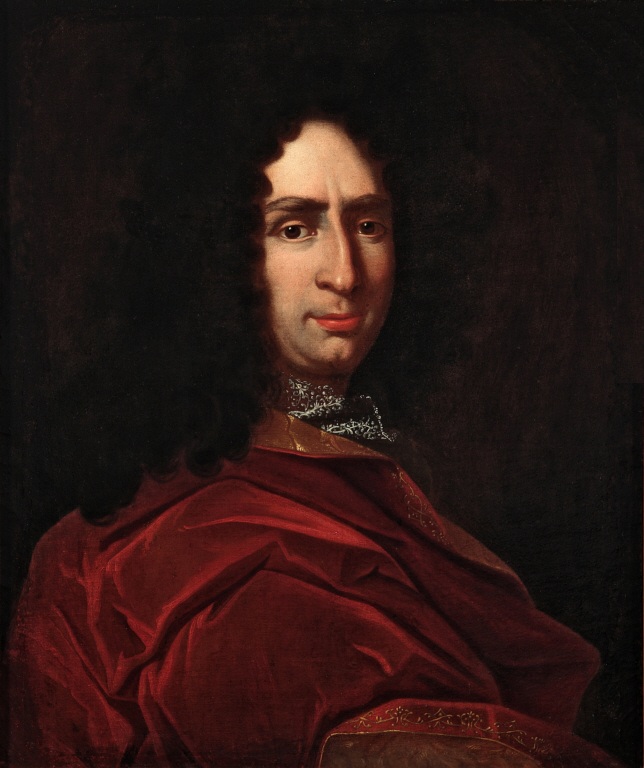
Governor of New France, Jacques-René de Brisay, Marquis de Denonville
The Ganneious villagers were rounded up and held prisoner by Jacques Rene de Brisay de Donneville and took them to Montreal. Two hundred prisoners from the now destroyed Kente and Ganneious villages. After 1687, all seven of the Iroquois Villages on the northern shore of Lake Ontario were abandoned.
Roughly ten years later, in 1696, the village was re-settled by the Mississauga group of First Nations, but was apparently completely abandoned by the early 1700s, and then the surrounding land and the Eastern Ontario land was sold to the British in 1783 as part of the Crawford Purchase. The location of Ganneious has since been lost in time.
LOCATING THE LOST VILLAGE
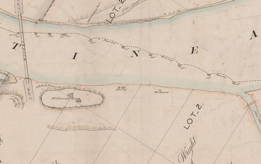
Sourcing a variety of old maps from both the 17th and 18th centuries that may help us locate Ganneious, it became difficult to pinpoint an exact location. The maps from that time period are not exactly to scale with many features unlike known reality and our current maps.
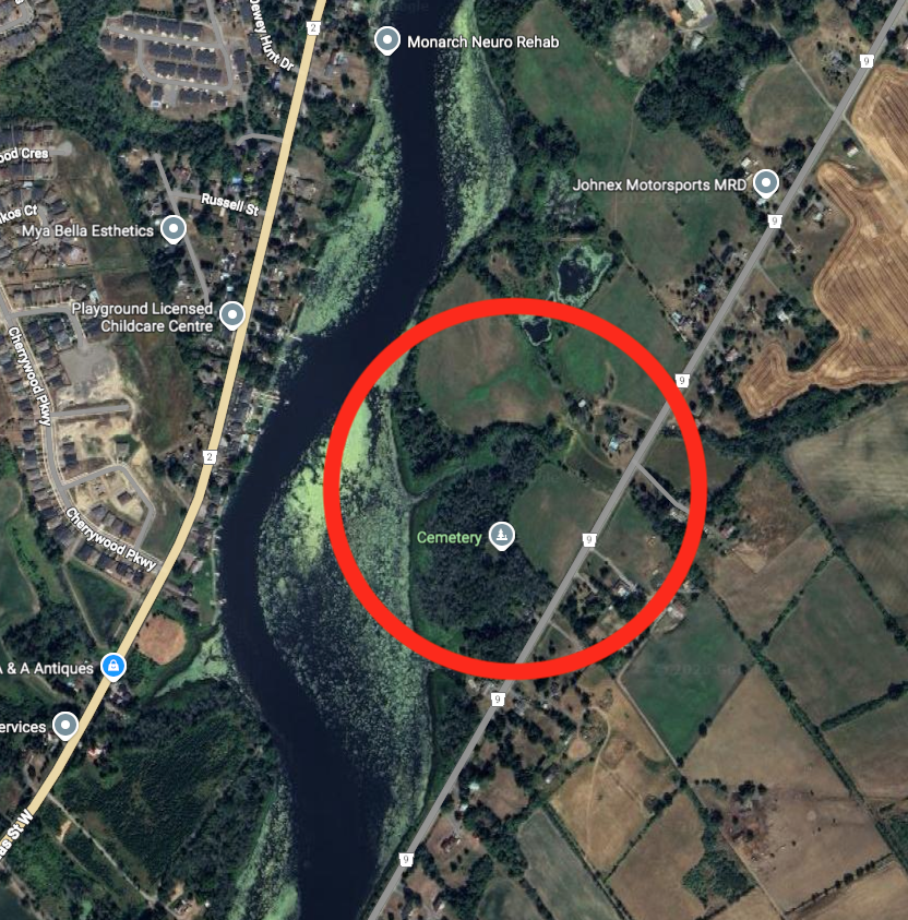
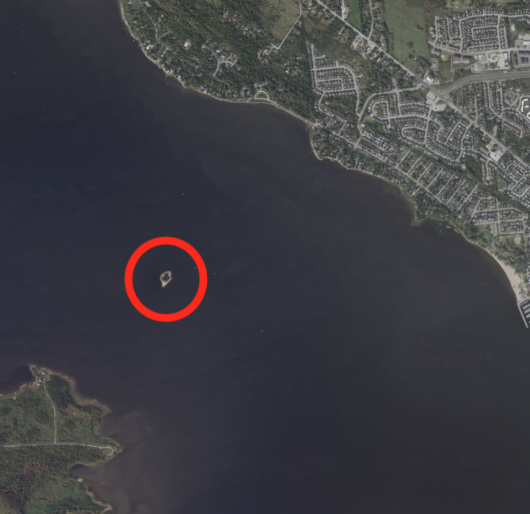
The earliest map I could find with Ganneious labelled is one from 1688, drawn one year after the village was destroyed by the French. It clearly shows a village labelled “Ganneious” west of Fort Frontenac (Kingston) on the northwest shore of a large bay, which I would speculate is Hay Bay in the Bay of Quinte.
1688 map
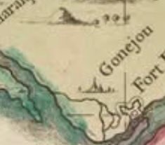
The next map I could find is one from 1733 that shows “Gonejou” marked with an illustration of village buildings. They also show it northwest of a body of water which looks to be a river of some sort, possibly the narrow part of Hay Bay.
1733 map
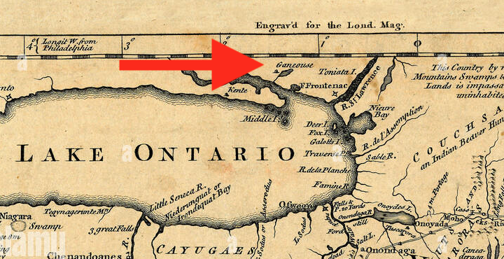
Next we have a map from 1756 made by the British that shows a village marked “Ganeouse”, again on the northwest shore of a body of water with a thin river leading to it. Again, I believe this to be Hay Bay.
1756 map
A British map from 1758 gives a more detailed look at the location, showing again, “Gannejouts” located on the north shore of Hay Bay just above where the narrow part opens up to the larger part of the bay. The Napanee River can be seen to the west of that, placing it in between. Some illustrative buildings indicate the “village”.
1758 map
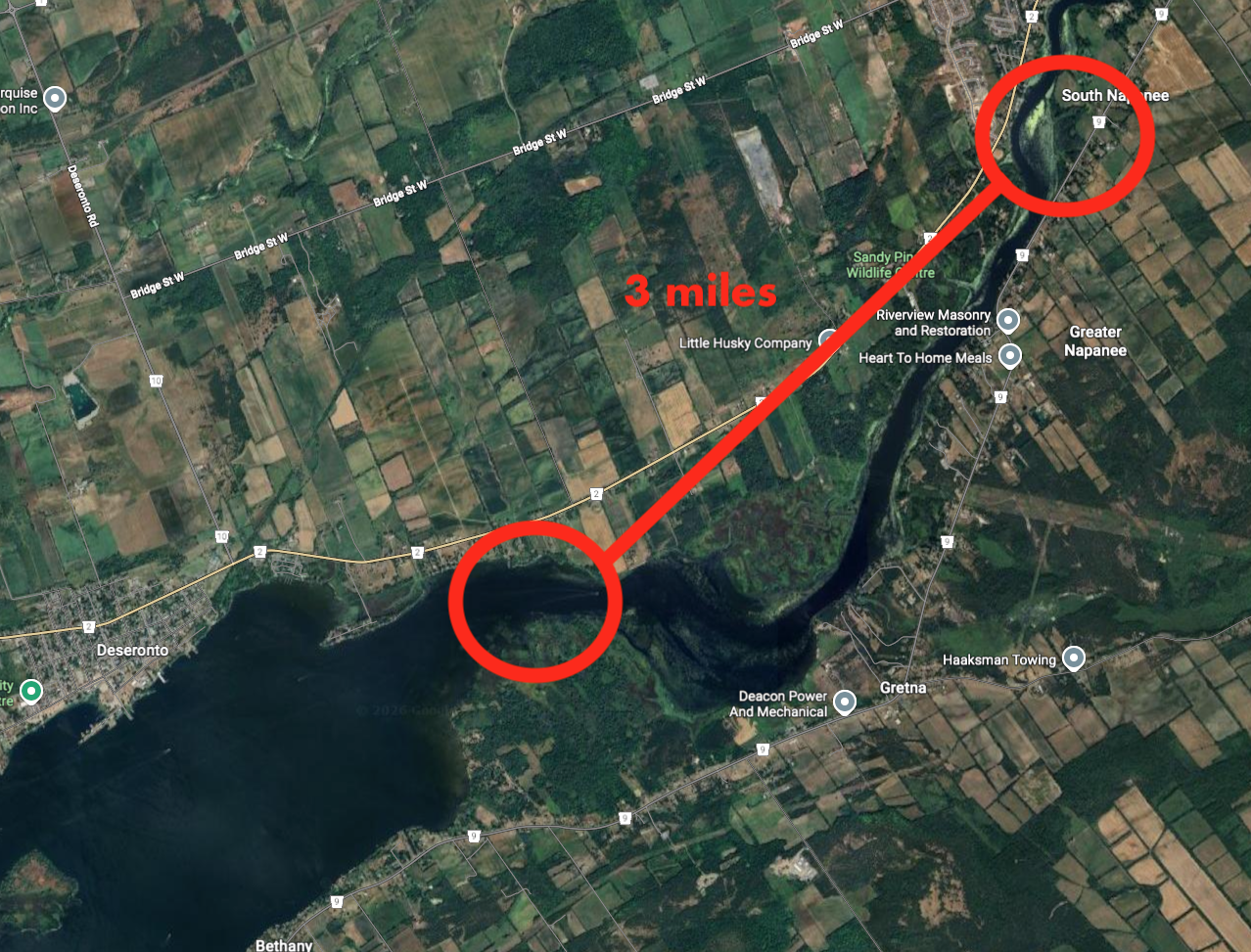
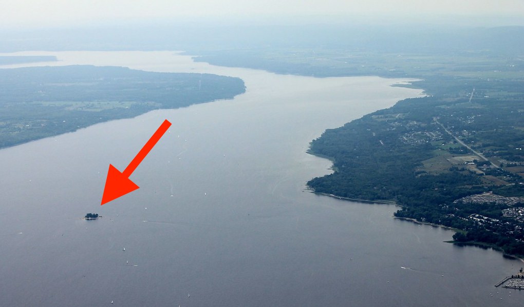
Our village in question then disappears off of maps soon after that and becomes lost in time. Heading to the local library in Picton, Ontario I came across a book called “Lennox and Addington” by Orland French who makes a fascinating claim the location of the lost village is off the Napanee River where two wrecks of French boats were found:
“About three kilometres upriver from its mouth there is evidence of a French trading post. A French bateau has also been found in the Napanee River next to this site.”
Measuring the distance and area where possible 17th century French boats were found.
The location of possible 17th century French boats that were apparently found along the shoreline of the Napanee River.
I could not find the source of the claim to follow up on it, but if anyone else knows about this, please let me know.
SPECULATING A LOCATION
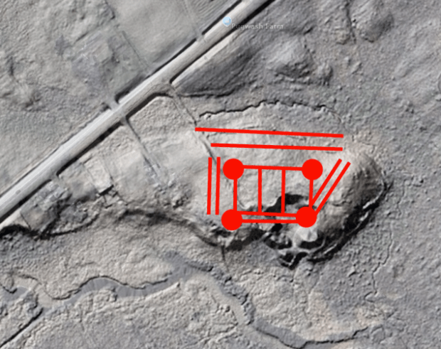
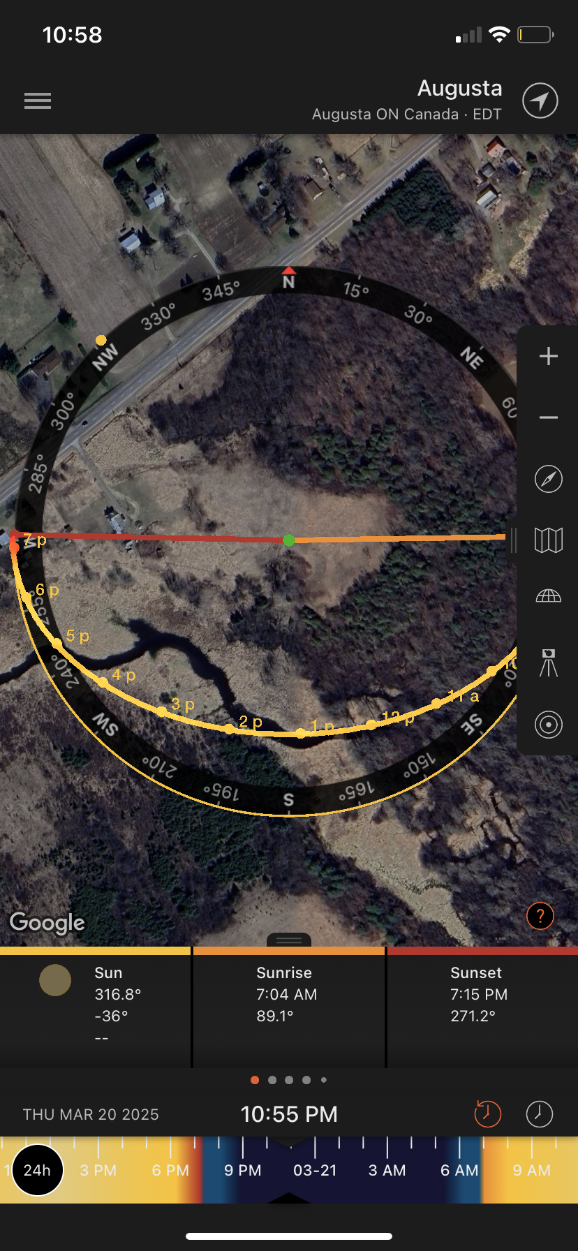
Referencing the old maps collected it seems our search now will narrow us into the area of the north shore of Hay Bay, near Napanee. The lost village is marked as being north of the large “lake” of Hay Bay, slightly inland inland from the narrow river.
This is the area I believe the lost village is located within.
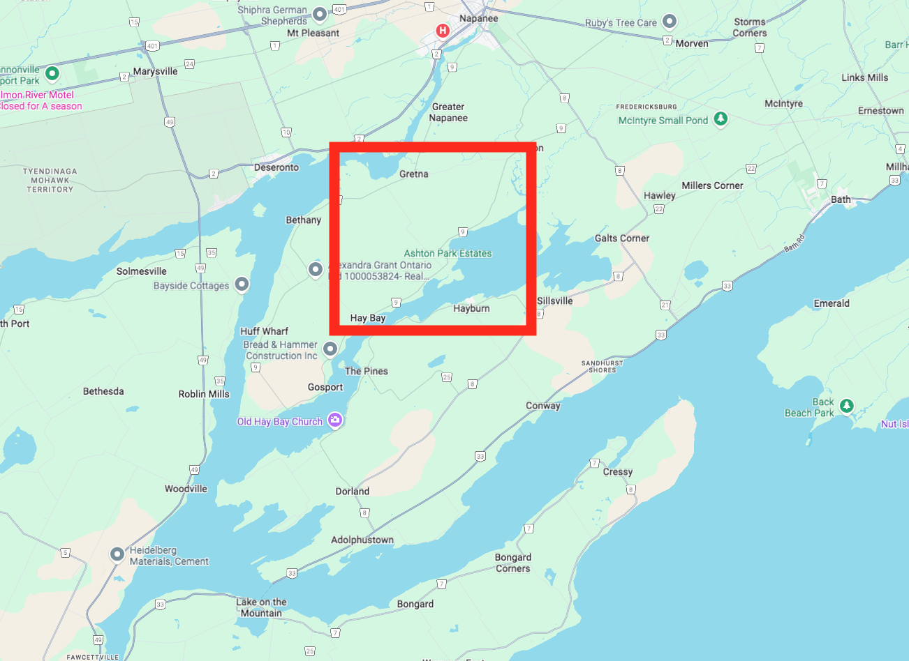
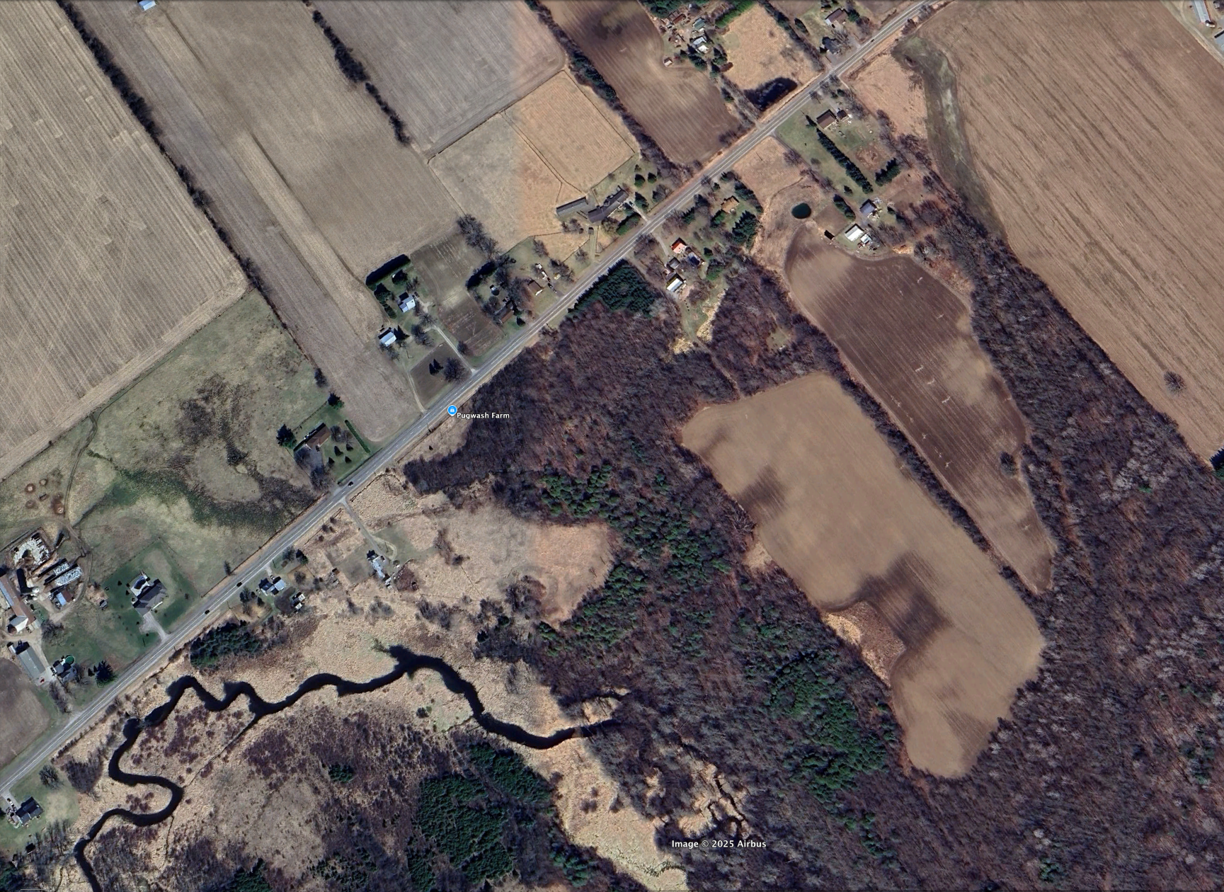
Using current Google Map imagery, we can roughly place Ganneious in the area that most closely resembles that geography, which places it in a certain area near Gretna.
A closer region of study…
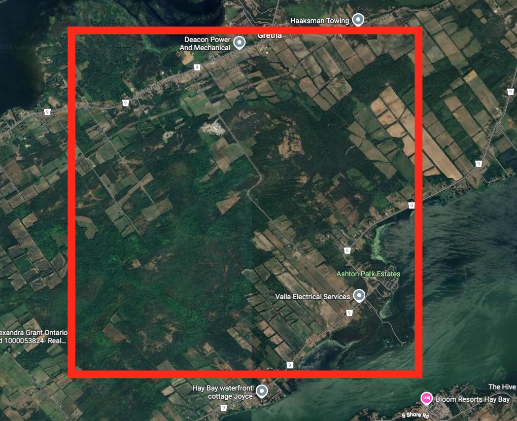
Having now narrowed that area down a bit, we can see that it is a mix of farmland and forested area…perhaps Ganneious lies somewhere in here…chances are it was probably plowed over by unsuspecting 19th century farmers who cultivated and cleared the land, not knowing a 1600s Iroquois village was there.
Forested area that may contain the lost village…
However, there are some areas that seem to be untouched forested areas. Perhaps within those regions something may give a clue to a location.
More target area of where the village could be located.
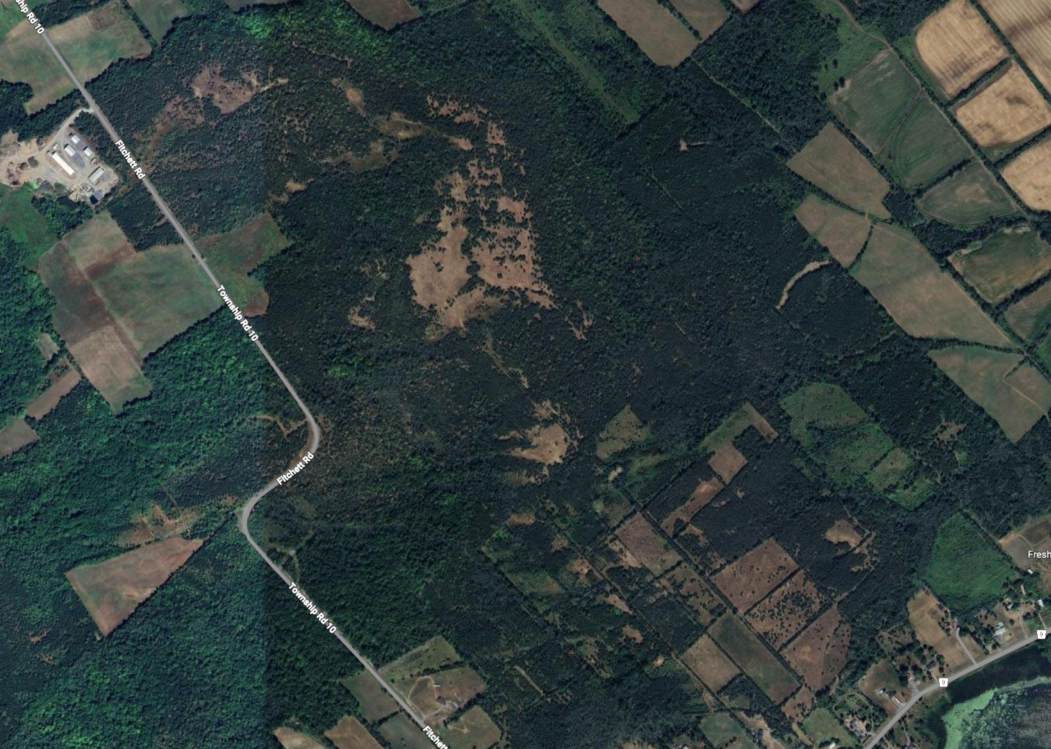
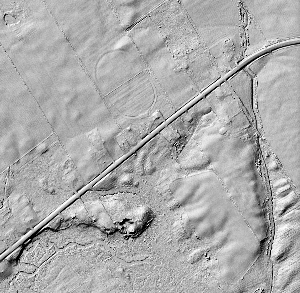
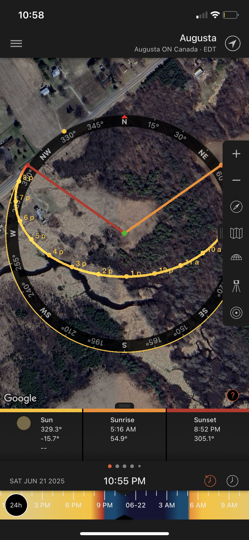
Using the Government of Canada Lidar 3D mapping tool, I was able to locate this area and use it to remove all the foliage and see the details of the topography and any unusual mounds or features that could indicate man made structures.
Lidar imagery of the broader area…(shown below)
I am not familiar with the village building modus operandi of the Iroquois and where they likely would pick a location to build a village, but I would assume it would be on “high ground” as that provides the best protection from attackers and gives a better vantage point to look around the land.
Unusual oval structure on Lidar imagery in forested area shown below…
Using that logic we can zoom in on a noticeable plateau in this region where two peculiar features can be seen. What looks to be man made, oval shaped structures that could indicate some kind of walled fortification structure around a village.
Another unusual oval structure on Lidar imagery in forested area shown below…
This of course is pure speculation of course, and it would take some professionals to gain access and study these targets.
CONCLUSION
Using a combination of old maps and modern day imagery we can speculate where the Lost Village Of Ganneious may lie, just northwest of Hay Bay in an area that contains some curious structures. This area is somewhat removed from the Napanee River where Orland states some wrecks of French boats were found. Perhaps they were part of the original expedition to locate Ganneious from Fort Frontenac in 1675. French personnel might have landed there and moved southwards to Ganneious instead of entering the narrow river part of HayBay, or they were just boats the French used during their missionary visits to Ganneious.
Without further investigation Ganneious remains a lost part of our important and complex nation’s history, somewhere out there waiting to be discovered…and I hope I am around to experience such a discovery.
As the Year 2025 draws to a close, I wanted to post one last article that takes some of the stories from the past and re-imagines them using current Ai imagery. Up until now, I have personally sketched in ink by hand many of the subjects covered in Ottawa Rewind in an attempt to help visualize what that subject matter may have looked like because photos of them do not exist.
Artificial Intelligence, or Ai, has now advanced to the point where I can input my hand drawn sketches and it will re-interpret them as a 3D rendered models. I know Ai is a bit of a contentious issue for many, but I simply see it as another tool in my toolbox to help visualize the past where imagery of it simply does not exist. Like a pen or pencil, it is a tool that still needs a creative mind behind it to guide the process to a finished output. All I wish to do is use this new tool to help visualize a lost history in a way that can be clearly imagined, and in using my already completed sketches, I hope it does that for viewers both young and old, and those familiar, or unfamiliar with my past work.
As always, I thank readers for their continued support over the years, Ottawa Rewind has been a rewarding project for me for over ten years now, and in a retrospective format I have personally picked some of my favourite stories to be re-imagined here. Please enjoy these tales in historically chronological order with new added imagery that was not available to me ten years ago…Have a great year ahead and I look forward to sharing new adventures with you in 2026!
PLEASE NOTE: All these images were imagined by Ai using the input of my original hand drawn sketches from my original articles that can be found using the “search” bar on this website.
–Andrew King, December, 2025
1400s: IROQUOIS VILLAGE “ROEBUCK”
Ai generated image of how the Roebuck Iroquois Village may have looked. (Grok)
Discovered in 1912, an archaeologist William Witemberg with the Museum of History excavated a peculiar site near Prescott, which he called “Roebuck”. Residents of the property kept finding human skeletons protruding from the grounds, causing locals to question what was buried in Roebuck. The Museum of History was contacted and Witemberg arrived on the scene to investigate. What he and his team uncovered was a centuries-old palisade enclosed village that covered an area of 8 acres.
Archaeological excavations uncovered stone tools such as scrapers and adzes, bone needles and knives, pottery vessels and earthenware pipes and dozens of human skeletons. It seems approximately 500 years ago an Iroquoian agricultural community of about 1600 persons occupied the site. Archaeological excavations suggest that there were approximately 40 communal longhouses 30 metres in length surrounded by a double-walled palisade. The farmers on the site grew corn, beans, squash, sunflowers and tobacco.
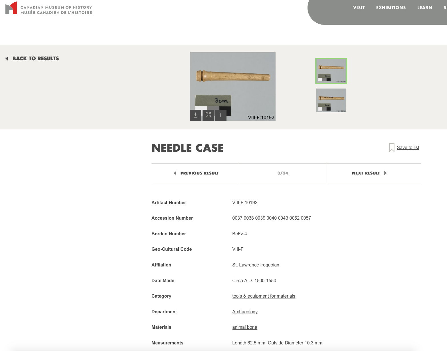
Wintemberg soon discovered a a piece of “carved bone,” that he described as “suspiciously European.” This suspiciously Out Of Place Artifact was then stored away in the museum warehouse where its origin remained a mystery….until 2017 when the new Canadian History Hall required a fresh look at possibly important, but forgotten artifacts in storage. According to former Curator of Central Archaeology at the Canadian Museum of History, Jean-Luc Pilon, the curious bone object was studied in detail and using a small sample taken from the odd cylindrical object it was carbon dated with an accelerator and mass spectrometer. The final results of the dating put the oddity at a date of between 1499 and 1578…and was determined to be a European machine lathed bone needle case for metal sewing needles. But how?
Ai generated image of the bone needle case dated to the 1500’s found at Roebuck. (Grok)
One answer could be that the object was traded between tribes and made its way from the East Coast all the way to Roebuck south of Ottawa. Another theory is that a new European visitor made their way to Roebuck in the mid 1500’s, a castaway from Cartier’s expedition, or perhaps an expeditionary group using smaller boats came into the area and left behind objects of their making. The object was found among other dated Iroquois objects of the time which ruled out it was dropped there at a later time.
Witemburg describes a bustling, but grim time in Canadian history as he and his team uncovered 85 skeletons and noted “The skeletal remains from the graves are undoubtedly remains of the people who inhabited the site.” but does not include the cannibalized, dis-articulated remains of 35 additional individuals. Wintemberg would note that these cannibalized bones “may have been people of the site but it is more likely that most of them are the bones of enemies who had been roasted and eaten.”
1660: DOLLARD’S PALISADED FORT
Ai image of what Dollard’s palisaded fort may have looked like. (Grok)
The May 24th weekend, or Victoria Day for the rest of Canada, is a bit different in Quebec where it is unofficially known as “Fête de Dollard”, in recognition of this character he will soon discuss. In 2003, provincial legislation officially declared the date to be National Patriots’ Day. A central figure of this Quebec patriotism is a young man named Adam Dollard des Ormeaux, a 25-year-old commander of Montreal’s (then called Ville-Marie) garrison. In April of 1660, Dollard requested permission from Governor Paul Chomedey de Maisonneuve to take an expedition up the Ottawa River towards present day Ottawa to attack a war party of Iroquois before they could reach Ville-Marie and its few hundred inhabitants. Dollard believed that many Iroquois warriors who were encamped along the Ottawa River were preparing to destroy the French settlements at Ville-Marie, Quebec City and Trois-Rivières.
Dollard said he could surprise and ambush the Iroquois warriors before they could begin their campaign against New France. After assembling a force of sixteen volunteer riflemen and four Algonquin warriors, including Chief Mituvemeg, the expedition left Montreal in late April of 1660 with several canoes, filled with food, ammunition and weapons.
Fighting the strong current of the Ottawa River, Dollard and his men finally reached their destination in early May, an area thought to be a good place for an ambush of the approaching Iroquois coming downriver from present day Ottawa. At the site he chose there was already an abandoned Algonquin fort built along the river made up of trees planted in a circle, cut down to trunks. Forty Hurons, under Chief Etienne Annahotaha came to this position to assist Dollard with his ambush plans. Dollard wanted to create a strong fortress from which to launch his attack, so he and his men reinforced the old fortification by building a new wooden palisade around the wall of existing tree trunks, but the Iroquois soon arrived before his new fortress could be completed.
The Iroquois approaching from the west came down the Ottawa River and quickly arrived at Dollard’s position, and in reaction Dollard engaged the Iroquois with musket fire. The result was an immediate assault made upon the fort by the Iroquois, but it was repulsed by the Frenchmen inside. The retreating Iroquois took the French canoes they had left on the beach, broke them up and set them on fire, using the burning wreckage to set ablaze Dollard’s new wooden stronghold. The French and their Huron allies were able to resist the attack and in doing so, killed a chief of the Seneca.
In what was a horrific and brutal scene, the French took the corpse of the Seneca chief and placed his head on a sharpened pole of the palisade as a grim warning to the remaining Iroquois. However, the infuriated Iroquois responded by calling in 500 more warriors to the scene. The Hurons loyal to Dollard, now witnessing the huge army of Iroquois in front of them, decided to defect over to the other side, except for the Huron chief, who loyally remained with Dollard.
The Iroquois wanted revenge and got busy building wooden shields called “mantelets” that were able to repel the firing French musket balls. After a week of back and forth harassment, the final battle began, and now armed with their shields, knives and axes, the Iroquois chopped through the fort’s walls and started pouring into Dollard’s wooden stronghold.
Sensing imminent defeat, Dollard then ignited a keg of gunpowder inside the walls of his fort and prepared to hurl it down on the Iroquois attackers, but when the bomb left his hands, it struck the palisade wall, bounced back and exploded in his own fort. With the overwhelming Iroquois forces now inside his walls, Dollard and the defenders were quickly killed in a gruesome skirmish that left only 4 Frenchmen alive, three of them quickly burned alive within the fort, and a fourth being taken prisoner, later tortured and killed. Fearing more intense battle bloodshed ahead, the Iroquois decided to pull back their planned attack and retreated west to Ottawa, deciding it wise not to unleash more havoc in Ville-Marie where the French likely had more muskets and cannons.
Dollard was defeated and the Iroquois achieved their revenge, but the history books say that the young Frenchman managed to scare off the attacking Iroquois, saving Ville-Marie and the rest of New France from imminent bloodshed.
A journal article published in 1960, entitled “The Lost Battleground Of Long Sault” by National Museum of Canada archeologist Thomas E. Lee, who weirdly published his report through the University of Rome. Reading the report, it clearly outlines an extensive archeological dig done by Lee in the 1950s that indeed uncovered a burnt out palisaded fort…BUT, it was on the Ontario side of the Ottawa River. However, all this new historic evidence was soon conveniently submerged underwater, flooded out when the nearby Carillon Dam was built in 1959.
1673: FIRST SHIP ON THE GREAT LAKES
Ai generated image of the first ship on the Great Lakes launched in 1673…”Frontenac” (Grok)
The Great Lakes are the largest group of freshwater lakes on Earth, a vast network of lakes that ultimately connects to the the Atlantic Ocean via the St. Lawrence River. They have been traversed for centuries by those that inhabited its shores, first using dug out canoes stretching back 12,000 years ago. These ancient water dwellers lived and utilized the Great Lakes not only as a source of food, but as a network of highways for them to trade. Around 1000 AD these ancient mariners traded copper nuggets from Lake Superior which made their way down the Mississippi River into Southern Ohio, and even into Florida.
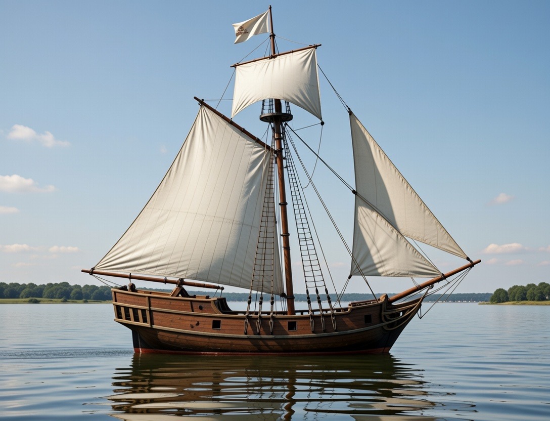
It would not be until the 17th century that the Great Lakes would see its first large sailing vessel on its waters. In July of 1673 Louis de Buade, Comte de Frontenac et de Palluau, better known as Count Frontenac, the Governor of New France, traveled to a place called “Cataraqui”, where the river that bears that name, and the St. Lawrence River meet at the eastern end of Lake Ontario. Now called Kingston, it is a strategic location since it is at the confluence of these three waterways where the fur trade could be easily monitored and controlled. Under the advisement of explorer and fur trader René-Robert Cavelier, Sieur de La Salle, this spot was chosen to build a French fort to control the lucrative fur trade in the Great Lakes Basin to the west. La Salle was left in command of the fort in 1673, where he immediately built a wooden fort and a harbour to contain a future fleet of sailing vessels which could control the expansive waters of the Great Lakes.
The first of these ships built in 1673 by LaSalle at Fort Frontenac was constructed at what is now the intersection of Ontario Street and Barrack Street in Kingston, ON. This would have been the very first sailing vessel built and launched on the Great Lakes, (if you don’t believe that Vikings had already ventured down the St. Lawrence and sailed here 600 years earlier). The rapids at LaChine in Montreal had prevented any large sailing vessels to pass south into Lake Ontario, so new ships would have to be built at Fort Frontenac if they wanted to sail the Great Lakes.
This first boat constructed is said to have been called “Frontenac” after the Governor of New France, and was a sloop type vessel of about 10 tonnes, with a single mast. It would be this vessel that would carry two men, LaMotte and Hennepin to Niagara where they would establish a construction site to build the bigger LeGriffon launched near Niagara, Ontario in 1679.
1692: FORT SENNEVILLE
Ai generated image of what Fort Senneville likely looked like. (Grok)
This fort is the westernmost stone fortification built by the French on the Ottawa River when they constructed a protective string of 30 outlying forts to repel the Iroquois threat to the expansion of French settlements. Originally the fort was constructed of wood in 1671 and was attacked by the Iroquois in 1687, a year after a fortified stone mill was built on the site that also served as a watchtower overlooking the Ottawa River. The initial attack was repulsed, but the Iroquois returned in greater force in 1691 when they successfully attacked and burned the wooden fort to the ground.
Governor-General Frontenac then ordered the construction of a stronger, more substantial fort, and in 1692 Fort Senneville was constructed using thick stone walls and corner tower bastions, cannon ports, musket ports, and extensive swivel wall guns. Fort Senneville on the Ottawa River was the “most substantial castle-like fort” near Montreal.
This new fortress was never attacked again. It remained a stronghold on the easternmost end of the Ottawa River near where it meets the St. Lawrence River, a strategic location for shipping and fur trading operations.
This imposing castle-like French fortress was ceded to the British in 1763 after the fall of New France and it remained an unused outpost. However, in 1776 during the American Revolutionary War, the fort was doomed. Benedict Arnold leading his Continental Army troops in military maneuvers during the Battle Of The Cedars took over the fort and burned it to the ground as they retreated back to the United States. Arnold successfully destroyed the fort before he switched sides and joined the British around 1780.
The ruined Fort Senneville was purchased in 1865 as a summer residence by the former prime minister of Canada and mayor of Montreal, John Abbott. The property then changed hands again in 1898 to Edward Clouston, the General Manager of the Bank Of Montreal. Since then the property has been privately owned and the hidden stone fortress remains cloaked under trees on the shores of the Ottawa River. It was designated in 2003 by Quebec for historical significance by classifying it as a “site historique” . Archaeological research and repairs funded by the Ministry of Culture and Communications has helped preserve what remains, and in 2009 it became a National Historic Site.
1706: SULPICIAN FORT RUINS
Ai generated image of the 1700s Sulpician fort and chapel. (Grok)
An island near Montreal off the main highway is called “Ile-Aux-Tourtes” and it has turned up some incredible information that indicates a unique history to this island. It seems archeological investigations between the 1990s and 2000s revealed that there are stone ruins hidden amidst the forest in addition to evidence that it was occupied 6000 years ago. It was notably used as a burial site as bleached bones were found buried in a pit covered with flat stacked stones in a funerary ritual associated with the Lower Woodland period (3000 to 2400 years ago). Also found were ceramic shards and stone tools belonging to a variety of prehistoric periods.
Fast forwarding through time, it was also discovered that this was a commercial area linked to the fur trade, and most remarkably the remains of built stone structures that indicate a presence sometime in the early 1700s. The first building on the island was built by Breslay in 1706 which was a stone house which also served as a chapel. A stone church was built later in 1710, and then the palisaded “fort” promised to help protect the Indigenous people. These foundations were uncovered in the archaeological investigations.
The Sulpicians abandoned the fort for reasons unknown sometime in the 1720s and then nature took over and it remained a hidden piece of history for centuries. Until the end of the 19th century, Île aux Tourtes had several owners, but none seems to have settled there. The original stone buildings quickly fell into disrepair. In 1958, a gas pipeline crossing the island from east to west was constructed and in 1961 the construction of the Île aux Tourtes highway and bridge to Montreal likely disturbed the archaeological remains on the southern part of the island.
From a well travelled highway, to 6000 year old prehistoric tools, burial grounds, and a 300 year old French Sulpician fort with possible other hidden archaeological treasures, this curious island provides a fascinating glimpse at a hidden history that begs further investigation.
1759: SUBMERGED FORT LEVIS
Ai generated image of how Fort Levis may have looked in 1759. (Grok)
This island fortress submerged in the St. Lawrence River off Prescott, Ontario was the final stronghold for French forces during the Seven Years War with Britain in 1760. It was flooded out in 1959 along with countless other islands during the construction of the St. Lawrence Seaway. Today only a small portion of the island is visible above water. Most of it, including the fort area lies underwater.
Called “Isle Royale” by the French in 1759, a decision was made to build a fortification on the 800 foot island in the middle of the St. Lawrence to repel any invading British ships making their way up the river from Kingston. Abandoning a previous fort near Ogdensburg the French built the island fortress as a last ditch effort against the advancing British ships trying to take Montreal. Armed with cannons, a moat, ramparts, palisades and other fortress features, it was called FORT LEVIS. The island army even grew a their own vegetables in a garden on the east end of the island.
Originally to be built of stone, plans changed due to time restraints and Fort Levis was built out of wood and measured about 350 square with bastions in each of the corners. A loading dock area for supplies was on the north shore facing the Canadian side of the river. French Commander Pierre Pouchot took command of the island fort and prepared to defend what was soon to be a short lived fortress. It didn’t take the British long to begin their advance up the St. Lawrence River in their gunboats towards capturing Montreal so the fort was put into immediate action. French lookouts near Alexandria Bay saw two approaching British gunships, the Mohawk and Onondaga, and raced back to the fort and braced for impending attack.
The two British ships got lost in the maze of the Thousands Islands for a week, giving the French time to prepare for battle. The British ships managed to capture a French gunboat along the way, hoisting a British flag and re-naming it the Williamson and adding it to its fleet of now three ships to take on the newly constructed Fort Levis ahead. Surrounding the island fortress were other islands, now held by the British with cannons stationed and aimed at the French fort. Under the command of Major-General Amherst, the three British ships arrived at Fort Levis on August 19 1760 and a fierce Battle Of The Thousand Islands began.
The island fortress threw everything it had against the looming British trio of ships, blasting the newly captured Williamson 48 times with cannon fire. Amherst called a ceasefire and retreated for the night. At dawn the fort once again rained cannon fire upon the British ships while also repelling invading troops trying to storm the shores of the island. During the skirmish the fort managed to sink both the Williamson and the Onondaga to the bottom of the St. Lawrence. The island fort did not let up its defensive attack and Commander Pouchot pummeled the remaining ship, the Mohawk, with cannon fire, sinking it also. Three ships sunk. The British had nothing left to attack the fort with except their island cannons surrounding Fort Levis.
Surprised at the unbelievable tenacity of the island fort to protect itself from all angles, Amherst gave the go-ahead to switch the cannons to “hotshot”, balls of fire that would set ablaze whatever they impacted. British hotshot rained down on Fort Levis, and with the fort on fire and having exhausted all their ammo, Pouchot finally surrendered the besieged island to the British. Originally armed with 300 soldiers, the French lost 275 men during the battle. The British lost 26 men. The fierce week long island battle was to be a decisive and final fight between French & British troops on the continent. The island fort was rebuilt and renamed Fort William Augustus under the British, with Amherst carrying on to join other British troops that surrounded Montreal. On September 6, 1760 Montréal was surrendered by New France’s governor, the Marquis de Vaudreuil which brought an end to the French empire in Canada. The island fort was the last stronghold for the French and its loss to the British signalled the end to the war.
It is unclear what happened to the fort between 1760 and 1950 when the St. Lawrence Seaway began construction. A study of aerial images produced in 1954 reveals the outline of the fort ruins were still visible on the island before it was submerged. Whatever remained of the original fort slowly slipped underwater in 1959 when flood waters raised levels for the new seaway.
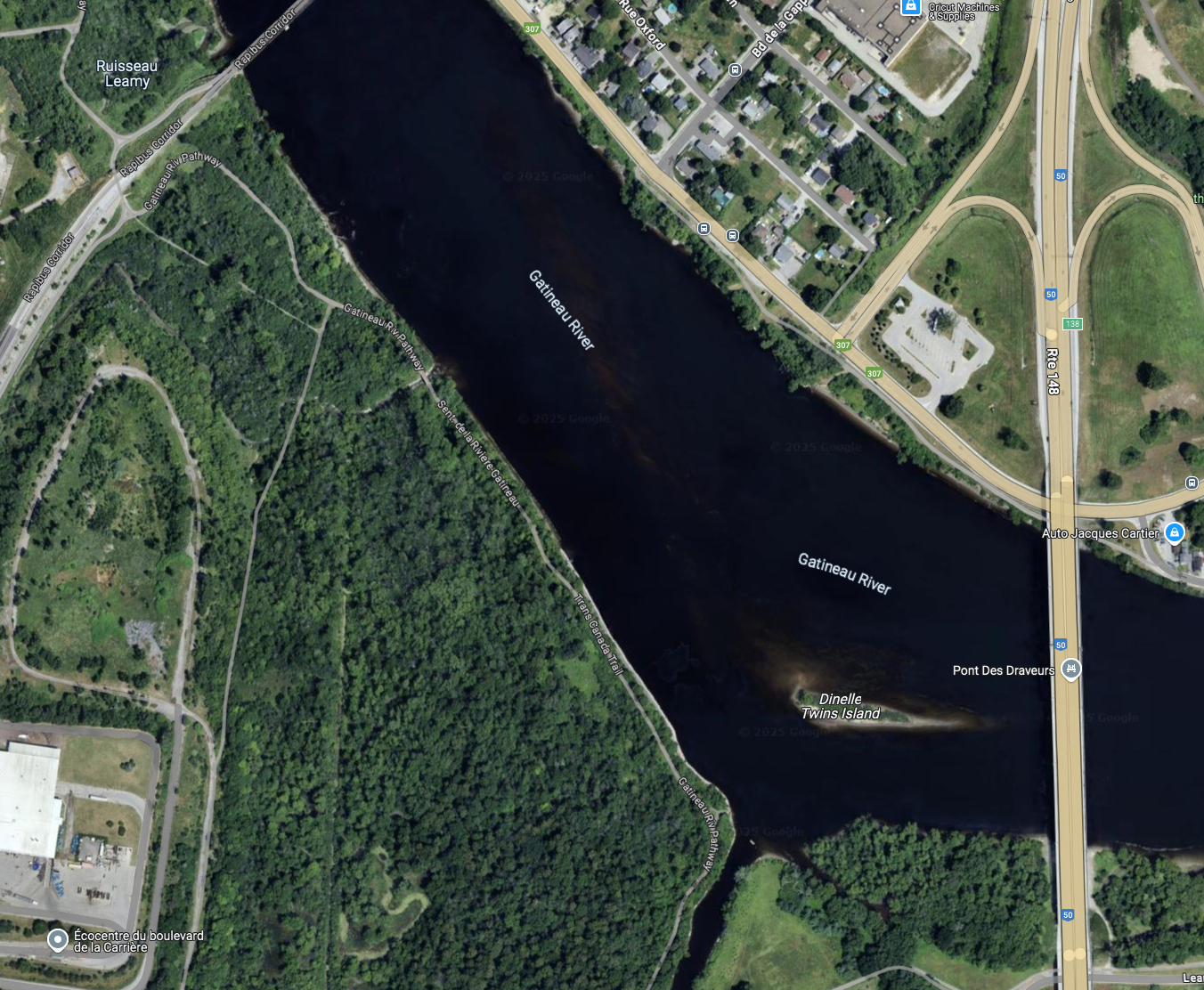
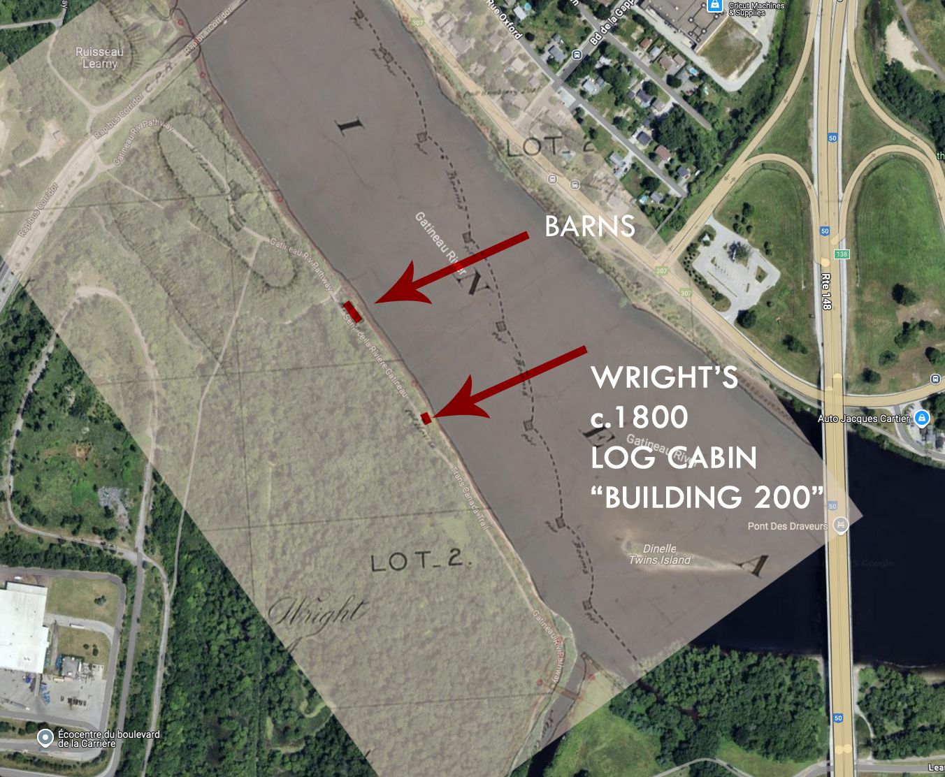
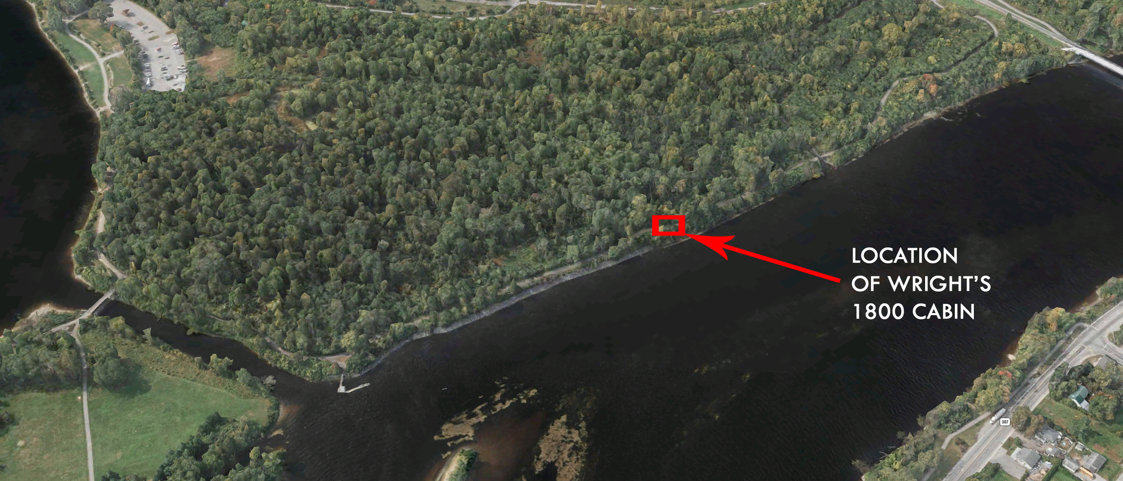
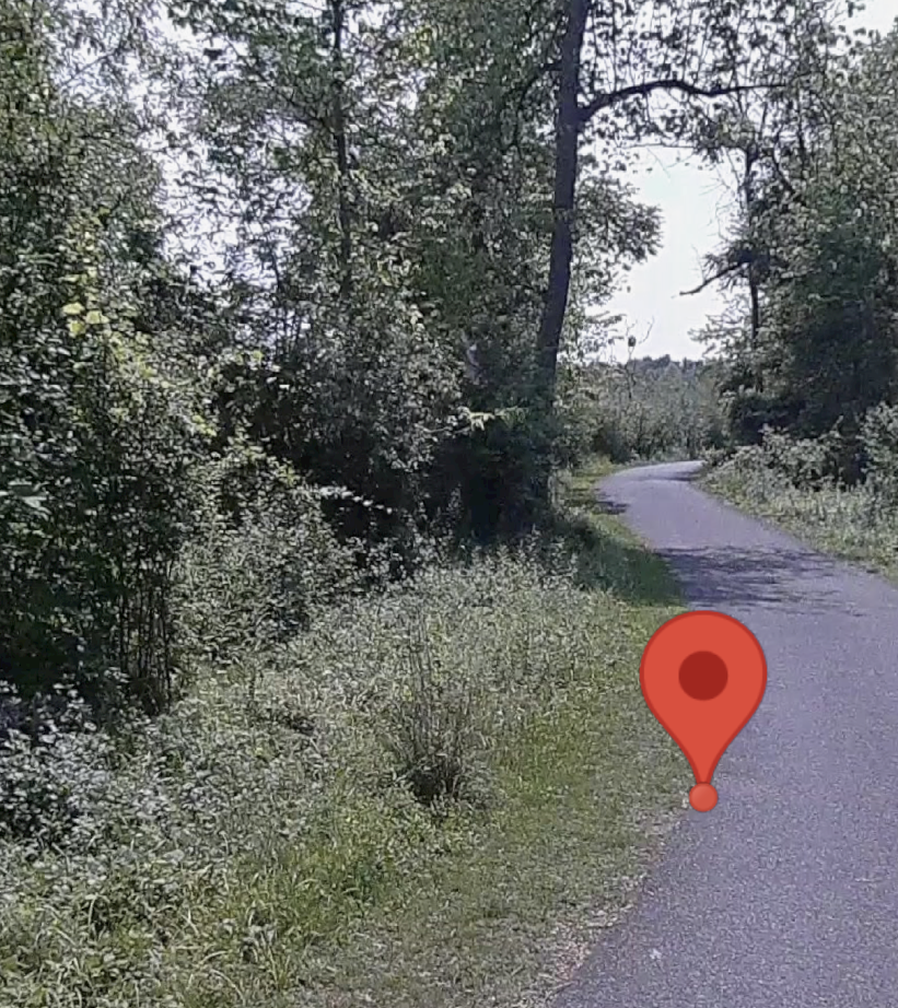
1812: OTTAWA’S OLDEST RUINS
Ai generated image of how Ottawa’s oldest ruins may have looked in 1812. (Grok)
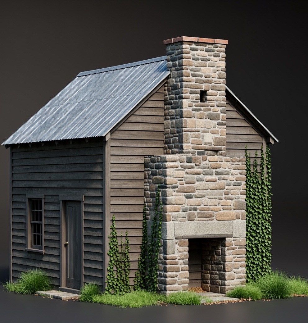
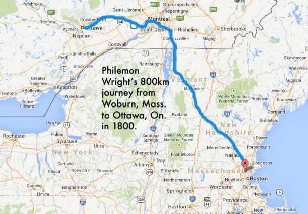
After the nomadic indigenous people harmoniously lived in the region of the Nation’s Capital for centuries, the first to build a permanent structure here was an American by the name of Philomen Wright, who in 1800 built a cabin over in Gatineau (ruins are on NCC property, unmarked…that story here). Next to arise was a shanty trading post operated by Jehiel Collins near the Chaudiere Falls in 1809. Nothing remains of this cabin, property now owned by the NCC. In 1810 Ira Honeywell built a log cabin in Nepean. Nothing remains of this cabin either, just an NCC plaque hidden off Woodroffe Ave. near the Ottawa River that vaguely tells us of Honeywell’s cabin nearby. Next to arrive was Braddish Billings who built his place in 1812 at what is now the intersection of Bank St. and Riverside Drive. A cabin was built by Billings along with some farm buildings. These would become the first permanent structures built in Ottawa after the Collins and Honeywell cabins.
Billings made his cabin of round logs with no windows with an opening without a door. Billings was likely attracted to the riverfront site because of its close proximity to the Rideau River, its abundant timber, its creek, and its fertile soil. Along with building a sawmill, he began clearing the land and planted potatoes, hay, corn, and turnips. He also continued lumbering for Philemon Wright. His ventures proved successful and in 1829 he built a substantial estate on the hill above his original cabin, what we now know as the Billings Estate Museum, owned and operated by the City Of Ottawa.
With his new big estate house, the original cabin structures Billings built in 1812 fell into disrepair, neglected and falling to ruin. A Methodist church was constructed next to one of Billings cabins, a wooden structure, that one book says is Billings first house, with a stone chimney that remained on site until 1960 when the NCC demolished it, and the church, for a new Riverside Drive. Taking stones from this old cabin, they built a small wall out of it, which is what we now see at the side of the road.
1819: OTTAWA’S FIRST PUB, FIRTH’S TAVERN
Ai generated image of Firth’s Tavern, Ottawa’s first. (Grok)
Once called Bytown, this city had a place of great merriment, a place where thirsty labourers and travelers alike would gather to relax and have fun…it was Ottawa’s first pub, a place called Firth’s Tavern. The Nation’s Capital has all but forgotten where this entertainment mecca was located and if we want to remind oursleves that fun is not forgotten here, maybe we should not forget where fun began. Let’s find where we once relaxed, partied and had fun.
Originally the “Chaudiere Inn” owned by Miss Dalmahoy, a brazen Scottish woman who soon married Isaac Firth. Together they opened the area’s first watering hole, “Firth’s Tavern” in 1819. Thirsty travelers, fur traders, voyageurs and military personnel of the time all gathered at this new pub where beer and food could be had. Originally a log cabin structure, the Firth’s expanded their tavern operation to include a two storey hotel, stables and barn structures to accommodate the town’s growing population.
Wild nights of partying beside the rushing waters of the nearby Chaudiere Falls entertained a mix of people from all walks of life…decorated military captains drank among grit covered mill workers and soaked raftsmen of the lumber trade. It was a place where stories were told, songs were sung and the vibrancy of what was to become the Nation’s Capital was born.
The pub was almost closed when Lebreton who purchased the lands nearby tried to evict the Firth’s but Governor General Dalhousie, knowing the importance it had in the community, came to the rescue and saved Firth’s Tavern from closing. The Firth’s operated the pub until 1832, but future owners of the tavern stopped serving in 1836. The tavern then closed around 1860 and was soon forgotten as Ottawa’s landscape evolved and development covered any remains of this once important gathering place.
1821: PINHEY POINT TEMPLAR CHURCH
Ai generated image of Pinhey’s stone church at Horaceville. (Grok)
The ruins are part of a unique plot of land called “Horaceville” located twenty minutes north of Ottawa, a place one man built for a family he raised there. The buildings that still remain in both ruin and restorative state reveal an interesting past connected with an order of Knights from a time of the Crusades.
Hamnett Kirkes Pinhey arrived in Canada from England in 1820 to create a community according to his beliefs and wishes for an aristocratic village that was unattainable for him back in England. As the King’s messenger during the Napoleonic Wars, Pinhey was granted land in Upper Canada that he would use to build his personal empire. Traveling by boat up the Ottawa River, Pinhey picked a hillside location with a sheltered bay about twenty kilometres north of what was then Bytown to create his Utopian vision.
Arriving at the site, Pinhey and his companion erected a small log cabin to live in until his possessions and family joined him a year later in 1821. After establishing his business and family on the site, Pinhey built a village that included a stately stone manor, mills, barns, and eventually a church. He would call the place “Horaceville”, after his eldest son Horace Pinhey. Establishing himself as a man of prominence, he entered politics as a member of the Canadian Legislature. Pinhey died in 1857 but left behind an interesting legacy and a strange connection to a medieval Order of knights known as the Knights Hospitaller.
Built by Pinhey in 1827, the stone church displays a unique style of architecture that resembles that of a medieval English church. Pinhey designed it himself based on sketches from his notebook. Symmetrically constructed with unique “ogee” arch windows and doors and a prominent square tower with pyramid roof, similar to the Knights Hospitaller churches and their motifs. A tomb of a medieval era Knight Hospitaller in England has the exact same ogee arch incorporated into the box tomb. Upon his death in 1857, Pinhey was buried in a “box tomb” on the west end of the church. The church fell into ruins sometime at the turn of the 20th century after it was abandoned in the late 1800s. It remains the oldest standing church within the City of Ottawa and is now a part of the Anglican Parish of March which maintains this unique hidden site.(NOTE: The church is on private property and I had permission to study it in detail. DO NOT TRESPASS) It has recently been given Heritage Designation as outlined by the Ontario Heritage Act but is not part of the City Of Ottawa’s Pinhey’s Point Historic Site and remains inaccessible to the general public. There is no official mention of Pinhey’s connection to this ancient order of Knights.
All these clues seemingly lead to a definite conclusion that Pinhey was, or was trying to be part of an ancient Order of Knights, but this could be all just coincidence. Not one to rely on coincidences, I dug deeper to in my research which revealed a book from 1857 at the New York Public Library entitled “Synoptical Sketch Of the Illustrious & Sovereign Order Of Knights Hospitallers of St. John Of Jerusalem and the Venerable Langue Of England”which comprehensively lists all members of the Order of Knights from its inception in 1099 to 1857.
Within its pages, on page 75, listed is the following:
“The Honourable Hamnett Pinhey, of Horaceville, Canada, Member of the Canadian Legislature, and one of the Governors Of Christ’s Hospital, London. El. K.J.J.” 1838: FORTRESS OTTAWA
Ai rendering of how Fortress Ottawa would have looked if it was built in the 1840s. (Grok)
After Queen Victoria chose Bytown as the capital of Canada in 1859, a strategic hill overlooking the Ottawa River was selected to be the site of the Parliament buildings. This area soon became the government precinct we know today. A drawing in the collections of Library and Archives of Canada, however, offers a glimpse of a very different vision for the nation’s capital, a city that, in an alternate reality, might have become known as Fortress Ottawa.
Plans were drawn up for an ambitious canal that would cut from Montreal to Kingston via the Ottawa River, providing a secure route and deterring any future American invasions along the St. Lawrence. Construction of the Rideau Canal began in 1826 and was completed in 1832. It still operates today, emptying into the Ottawa River beside Parliament Hill.
Tensions between Britain and America were renewed with the Rebellion of Upper Canada, which began in 1837 (the same year as the Rebellion of Lower Canada) and spurred fears that the new canal could be susceptible to American attack. Orders were given in 1838 to build wooden guardhouses along the canal, and to plan the construction of a massive stone fortress at a strategic location in Bytown.
John Burrows, overseer of works in the British Ordnance department’s engineering office, drew the first sketch of the fortress in 1838, but the plan had been originally envisioned by canal builder Col. John By, who wanted to create a series of defensive structures to protect the waterway once it opened.
For Bytown he called for a fortress stretching almost a kilometre from the Ottawa River to what now is Queen Street, and from the canal in the east to Bank Street in the south, covering what was then known as Barrack Hill and the site of a small military outpost.
This original drawing is catalogued at the Library and Archives of Canada as “Plan of By Town Showing the Proposed Fortifications Land taken from Mr. Sparks, Lot No. C in Connecticut C., Also Crown Reserve O” and labelled “Citadel Hill.” It is signed by Maj. Daniel Bolton, who replaced Col. By as canal superintendent and for whom Major’s Hill Park was later named. It was, in fact, Burrows who owned the land before selling it to Sparks.
Mapped out with defensive moats, trenches and cannon placements, Bytown’s sprawling stone fortification on the hill was a typical 19th century “star fort,” similar to Fort George in Halifax, also known as Citadel Hill, and the Citadelle de Québec in Quebec City. The “star fort” layout style evolved during the era of gunpowder and cannons and was perfected by Sebastien Le Prestre de Vauban, a French engineer who studied 16th century forts designed by the Knights of Malta. A star fort built by the order with trenches and angled walls withstood a month-long siege by the Ottoman Empire. This layout remained the standard in fort design until the 20th century.
Ottawa’s planned fortress would have also integrated a water-filled moat trench to the south, where Laurier Street is now, to impede an attack. On the northern side, the natural limestone cliffs along the Ottawa River would have served as a defensive measure. Access and resupply points were at the canal near the Sappers Bridge, and a zigzagging trench with six-metre-high stone walls would have run parallel to Queen Street. Parliament Hill, with its gently sloping banks to the south, was called a “glacis” positioned in front of the main trench so that the walls were almost totally hidden from horizontal artillery attack, preventing point-blank enemy fire.
After the rebellions were quashed and the threat of an attack from the United States fizzled out by the mid-1850s, Canada abandoned plans to fortify Bytown.
In 1856, the Rideau Canal system was relinquished to civilian control, and three years later Bytown was selected as the capital of the Province of Canada. The grand plans for Ottawa’s massive stone fortress were shelved and the area that would have been Citadel Hill became the scene of a different kind of battle, that of politics.
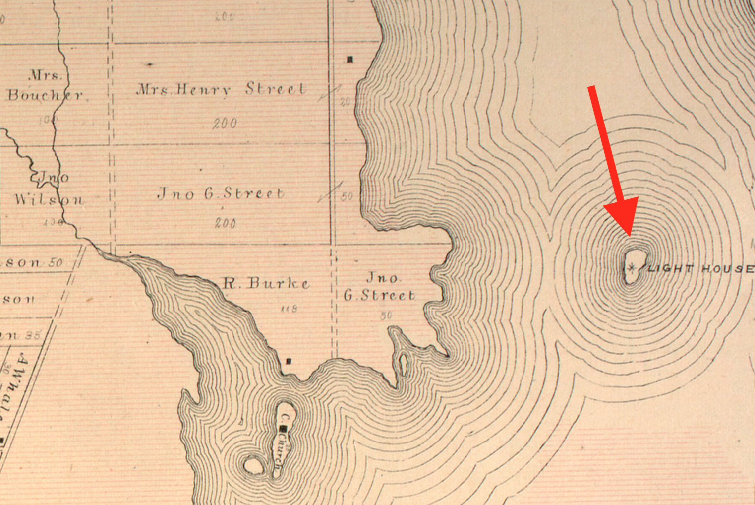
1860: BEACON HILL LIGHTHOUSE
Ai generated image of the 1860 Beacon Hill beacon…(Grok)
A few hundred metres north of the shore near Beacon Hill lie the remains of one of the Ottawa River’s lost lighthouses. Constructed in 1860 between the gaps of the the Ducks Islands near the provincial border, the lighthouse structure was built as a navigational aid to warn sailors of the dangerous reef of rocks known as “Green Shoal”. Navigating ships on the Ottawa River was a relatively new adventure in the mid-19th century, but with the construction of the Rideau Canal in 1832 and the Carillon Canal in 1833, the Ottawa River became a busy shipping and tourist route between Ottawa, Lake Ontario and Montreal before the advent of area rail travel.
The waterway was busy with steamships plying the waves between cities, but a number of shoals and islands created hazards for the vessels and required the need for warning lights to mark their location. The government at the time gave the order for the construction of approximately 30 lighthouses on the Ottawa River to assist in the safe passage of growing river traffic. Pre-Confederation Canadian lighthouses were usually built of stone or brick, but with the need to build so many new structures in time, the newly formed Department of Marine and Fisheries required cheaper and faster lighthouse construction techniques.
Built as four sided tapering wooden clapboard towers, these structures had the advantage of being cheap to build, and in some cases could be relocated if the site needed attention. The water hazard known as Green Shoal would seen see the construction of such a beacon structure in 1860 on a conical pedestal sheathed in iron boiler plates, riveted together like some kind of Jules Verne rocket to withstand the strong river current and sheets of crushing ice carried downstream. Atop this iron clad pedestal was placed a 4 sided white wooden pyramidal tower 21 feet in height. Using a standard design used for many of the Ottawa River lighthouses, the structure housed a fixed light that was initially fueled by Kerosene, a fuel invented by the Canadian geologist Abraham Gesner in 1846. The Green Shoal light was visible to passing ships from a distance of nine miles and eventually was rebuilt in 1900 when it was most likely converted to using an electric lamp.
The beacon remained in operation for more than a hundred years, being dismantled and replaced by an automated light marker sometime in the 1970s. It was at this time that a new suburb was being developed nearby, and from atop the hill on what is now Naskapi Drive, the neighbourhood got its name from the old beacon that was visible on the river below.
1860: ROYAL SHIPWRECK IN THE OTTAWA RIVER
Ai generated image of Anne Sisson, the waterline of the hull incorrectly floating above the surface of the water…(Grok)
In 1860 the Prince of Wales, future King of England, travelled along the Ottawa River aboard the steamship “Ann Sisson”. It was lost beneath the waves in 1871. Ottawa had recently been selected by Queen Victoria as the permanent capital of the Province of Canada, yet the Queen would never visit Canada as it was said she despised traveling on water due to seasickness. Instead, she sent her son, Albert Edward, Prince of Wales (later King Edward VII) in her place to make the first official royal visit to Canada in 1860.
After a whirlwind tour of Ottawa with residents and businesses giving Edward the “Royal Treatment”, the future King boarded the 139 foot side-wheeler steamship Anne Sisson in Aylmer to tour the young prince up the Ottawa River. This steamship was outfitted for the royal journey, its usual lumber ship duties altered when passenger accommodations were added. Owned by Brewster & Mulholland, from Montreal, they outfitted the ship for the Prince and his entourage to venture north on the river.
The Prince left Aylmer and steamed away in the royally appointed ship and as evening approached, the royal party decided to stay overnight in Quyon, Quebec. The next day she docked in Pontiac and boarded a horse railway there to take Edward on the remainder of his Ottawa Valley Tour.
The royal steam ship then returned to its duties as a lumber steamer, later strengthened, then became a passenger steamer in 1863 transporting passengers between Aylmer/Ottawa and Pontiac under the Union Forwarding and Railway Company. Records show in 1871 the once regal ship was stripped and abandoned in the Ottawa River, its location unknown.
Mike Kaulbars and his research on the whereabouts of the Ann Sisson lead to a mention in “The Carleton Saga”, a book by Harry and Olive Walker, where it was said a lighthouse keeper at Britannia by the name of Robert Winthrop, navigated in a boat around what he said was the wreck of a “famous boat of the Ottawa Valley fleet, the Ann Sissons”.
The ship was apparently beached and burned near the lighthouse. Kaulbars also uncovered information that a wreck was found in Britannia waters during the summer of 1962, but it was misidentified as the steamship Albert, which was almost identical to the Ann Sisson in both construction and size. Yet that ship, Albert, was recorded to be dissembled in Quyon in 1917, so it could not be in Britannia Bay. Kaulbars later found out it was indeed identified as the Anne Sisson, but no further information on its location could be determined.
One of the greatest resources I use for my research in historical studies is the amazing “Geo Ottawa” map program provided online by the City Of Ottawa. Using aerial photographs from 1928 onwards, it can give an accurate representation of what the city looked like from the air over the years. Using this, I was able to find the earliest aerial photo for the Britannia region, which happened to be 1958. Scanning this old aerial photograph, I noticed a curious looking shape under the waves. Zooming in on the shadowy shape offshore, it looked remarkably like the outline of a ship.
Using the scale of the map and comparing the its size to the approximate 140 foot length of the Ann Sisson, it seemed to be a perfect match. Overlaying that 1958 position with a current 2018 aerial map did not show any evidence that the shipwreck was still there, so I decided that an exploration in person was necessary to see if anything remains today.
Locking in the GPS coordinates of where the wreck was supposed to be, I also downloaded an app on my cell phone that tracks the users GPS position and displays the coordinates so you can walk around to your desired position. I trudged out into the waters of Britannia Bay towards my GPS target, and there in the shallow waters, obscured by sand, lay the wreck of the Anne Sisson.
Lying underwater, out of view hidden for decades, the ship’s charred wood revealed its fate of being burned and left to sink into the sand. The old paddle wheeler lies concealed by the shifting sands of time and waves of the Great River. A sad end, for a once important steamship.
1915: THE LOST RIDEAU YARD
Ai generated image of the now demolished Rideau Yard Roundhouse off Hunt Club Road. (Grok)
A piece of Ottawa history hidden for over 100 years off Hunt Club Road was redeveloped recently to make room for a new hotel and restaurants. It was grand vision for a new concept in Ottawa living called “Rideau Yard” and it was the nucleus of a town that never was. Part of this grand scheme for a new “resort town” south of downtown Ottawa was a large railway roundhouse, which was built and its remnants quietly survived for over a hundred years until the new Sandman Hotel was built over its ruins.
Constructed by the Canadian Northern Railway company, “Rideau Yard” opened with great expectations of handling both freight and passenger rail traffic passing between Quebec and Vancouver on the newly constructed TransContinental Rail line. This grand, new station south of Ottawa along present day Hunt Club Road near Antares Drive was an ambitious development that housed an 80-foot turntable and a 15-stall roundhouse, where steam locomotives were serviced. Later re-named “Federal Yard”, it was to be the epicentre for Ottawa’s newest suburb, which boasted a summer hotel and residential streets mapped out close to the Rideau River.
Yet this vision of a new town south of Ottawa never came to fruition and eventually fell into financial troubles. Canadian Northern Railway shut down Rideau Yard and the dreams of their south Ottawa development came to an end in 1922. The hotel was being used by railway employees instead of visiting passengers, and the roundhouse and other auxiliary buildings were demolished some time around 1930. Their ruins became cloaked in overgrowth up until 2017 when it was finally buried to make way for a new hotel and and development.
1970: OTTAWA’S NUCLEAR REACTOR
Ai generated image of the Nuclear Reactor at Tunney’s Pasture. (Grok)
The year was 1970 and the Atomic Energy Canada Limited, or AECL, was placing a SLOWPOKE-2 class nuclear reactor at Tunney’s Pasture. According to The Canadian Society For Mechanical Engineers documents, this nuclear reactor was installed in Tunney’s Pasture at 20 Goldenrod Avenue. It was constructed as a commercial testing reactor to determine its feasibility. This nuclear reactor was in full operation after it reached critical mass in 1971 until 1984 when it was then moved to another test site located in Kanata, later decommissioned in 1992.
The reactor, nicknamed SLOWPOKE, (an acronym for Safe LOW-POwer Kritical Experiment) which used 93% enriched uranium. The reactor core sits in a pool of regular light-water, 2.5 m diameter by 18 feet deep, which provided cooling. The reactor built at Tunney’s Pasture achieved “Critical Mass” or the point at which a nuclear reaction is self-sustaining on May 1 1971 and continued operating until 1984.
The oddly shaped circular concrete bunker that remains on the shore of the Ottawa River directly opposite the old nuclear reactor site was built at the same time as the reactor in 1969-70. It was built to facilitate the increased “cooling” needs of Tunney’s Pasture, one of them you could speculate being the addition of a small nuclear reactor.
The pumping station bunker and pipeline were finished in 1970 and the reactor began operating a year later. Whether or not the bunker pipeline bringing cooling water to Tunney’s Pasture was directly related to the addition of a nuclear reactor remains speculation but it is interesting to note the proximity and similar timeline of both projects.
You can follow the intake cooling water pipe by tracing a path that follows a series of manhole covers that lead from the river to the Tunney’s Pasture site. The buildings where the nuclear reactor once existed have since been demolished, and it is currently an empty gravel parking lot.
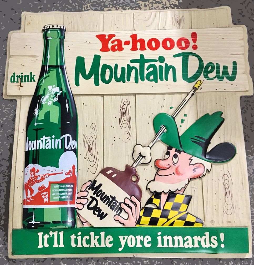
Approximately an hour and a half drive west of Ottawa will take you to the popular summer village of Westport, a quaint town nestled at the foot of Foley Mountain. Perhaps it was this mountain, or the fact it has always been a bustling summer tourist hub, that made it the place where Mountain Dew soda arrived in Canada with much fanfare in the year 1964.
Mountain Dew, a refreshing citrus drink that was originally formulated in the 1940s as a personal whisky mixer, hit American shelves in the 1950s but would not reach the Canadian market until 1964. “Mountain Dew” was the nickname for good ole Tennessee Moonshine, a name used by Barney and Ally Hartman, two brothers that bottled their own whisky mixer as they had trouble finding a suitable one they liked at the time. The Hartman brothers were traveling on a train and offered a fellow passenger a sample of their “Mountain Dew” mix who happened to be Charles Gordon, a soft drink promoter of “Dr. Enuf” brand elixir.
Charles Gordon, the man who brought the world Mountain Dew.
The Hartman brothers and Gordon then worked out a deal with the Tri-Cities Beverage Corporation to bottle and sell Mountain Dew in 1950. Sold regionally around Knoxville, Tennessee it wouldn’t be until 1961 that Mountain Dew was formally launched to a greater market when Tri-Cities was merged into the Tip Corporation. Then things really started to take off for Mountain Dew when Tip was purchased by Pepsi Cola, bringing it into their national and international distribution scope.
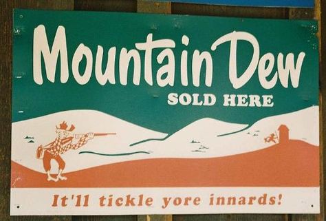
Under Pepsi, Mountain Dew was marketed as a “Hillbilly” drink and branded the bottles with a design and the motto “It’ll tickle you inards!”
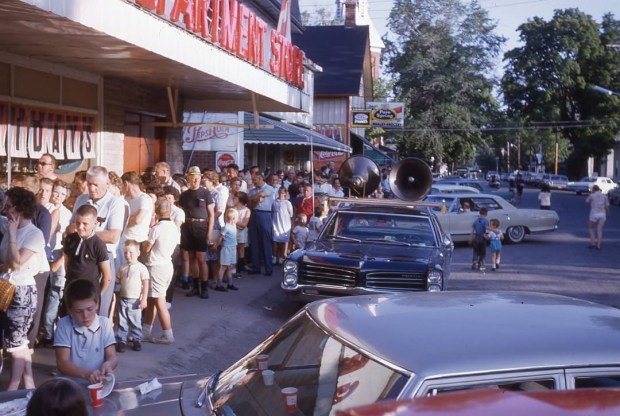
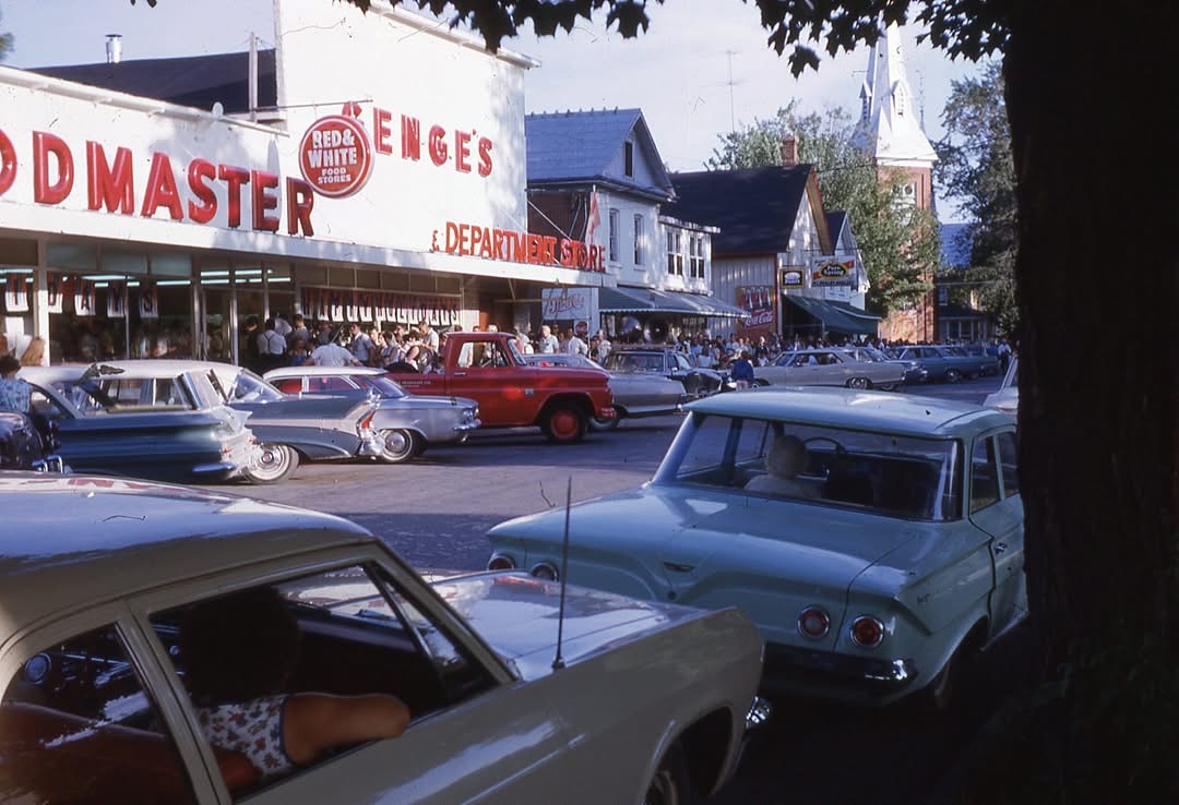
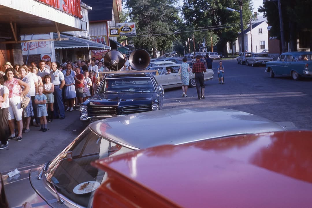
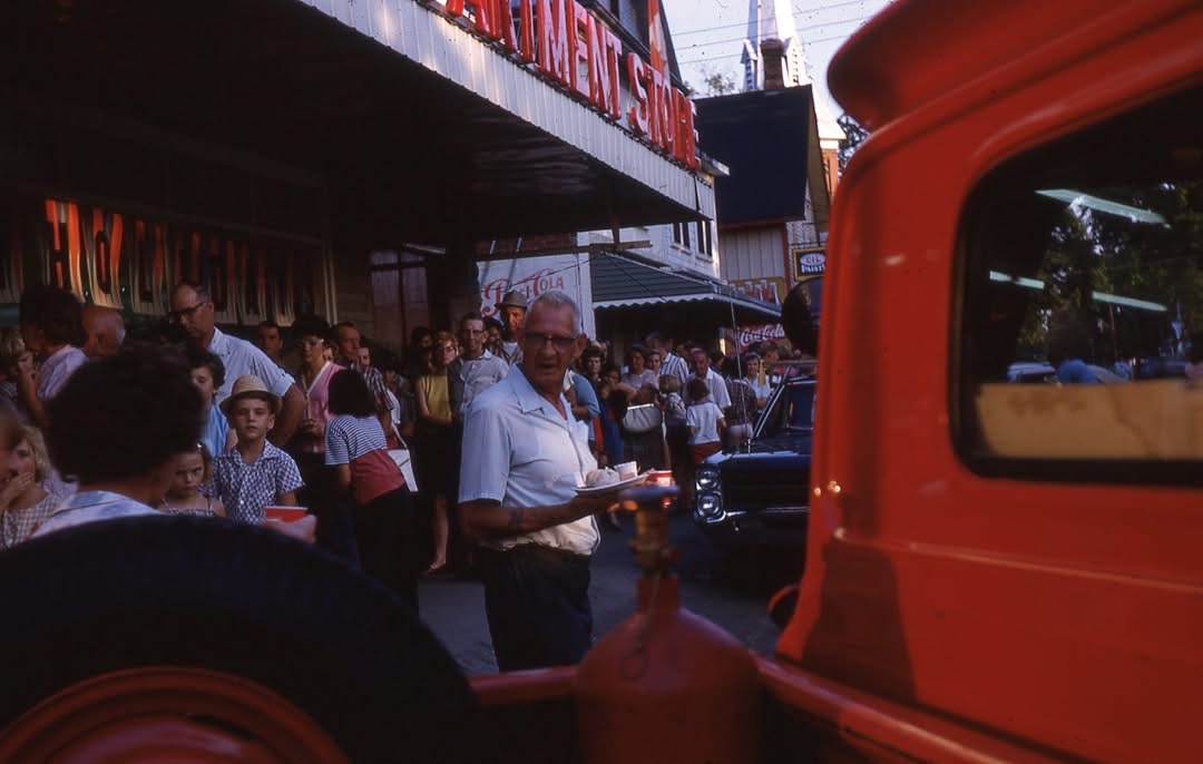
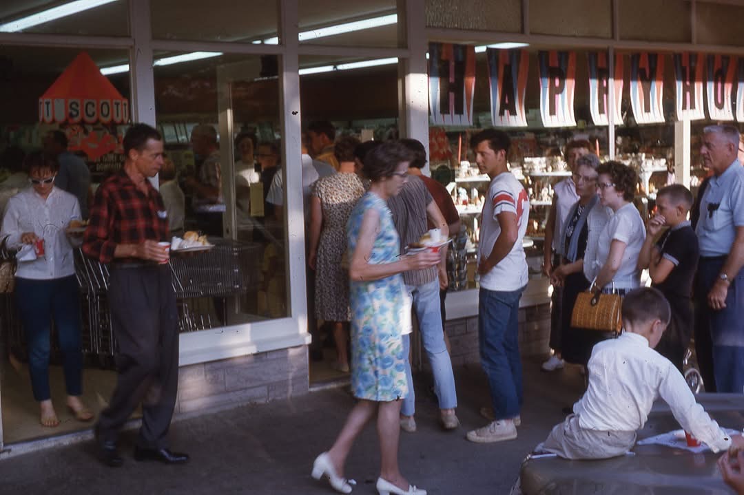
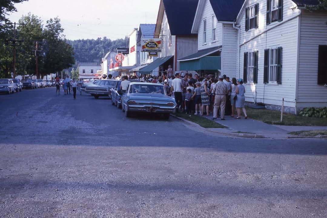
It was in that year that Pepsi took over the Mountain Dew brand that it arrived in Canadian stores, and according to the Rideau District Museum, there was a free meal and Mountain Dew sample promotion at the local Westport department/grocery store called “Genge’s”…(now The Village Green) These wonderfully rich and pure photos capture that moment in time when Mountain Dew arrived…
The Summer of ’64 when Mountain Dew came to town…people lined up down Westport’s streets to get a free sample and meal. Check out those sweet cars! (Photo:Courtesy Rideau District Museum)
Mountain Dew arrives in Canada in 1964 and thirsty Westportians want to try it! (Photo:Courtesy Rideau District Museum)
(Photo:Courtesy Rideau District Museum)
People lined up down the street to get a taste of the exciting new soft drink that summer in 1964, it is unclear if this was the first time in Canada launch that was in Westport, or if it was a coordinated launch across the country, but an amazing photo collection exists of the Westport Mountain Dew launch.
The town of Westport was thirsty to sample the newest soft drink, Mountain Dew, at Genge’s Department Store. (Photo:Courtesy Rideau District Museum)
The lineup for Mountain Dew went down the whole block…note the signage for Ottawa’s own Pure Spring Gingerale being overshadowed by the excited Mountain Dew crowd. (Photo:Courtesy Rideau District Museum)
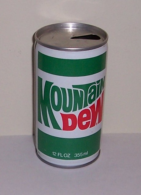
Despite the similar appearance and taste to the American version, the Canadian version of Mountain Dew did not contain any caffeine due to regulations that restricted caffeine to only be used in dark-coloured soft drinks. These regulations imposed by Health Canada, meant that Mountain Dew being a non-dark citrus flavoured soda, could not contain any caffeine. That regulation was dropped in 2012 and now Canadian Mountain Dew contains caffeine.
The re-designed 1969-70s Mountain Dew packaging, a logo design that would last until 1996.
The HillBilly motif of the 1964 Mountain Dew only lasted 5 years when the logo was re-designed to appeal to a younger, more hip generation, a classic logo and font design that lasted until 1996.
Whether or not Westport, Ontario was the official Canadian launch spot for Mountain Dew beneath Foley Mountain, the incredible collection of photos from the “Wing Collection” of the Rideau District Museum captures the excitement of that moment in time and offers a glimpse through the looking glass to hot, summer days of the past when ice cold drinks in glass bottles were the best thing to quench your thirst. And still are.
I would like to personally thank the Rideau District Museum for their kind allowance of using the photos from their Wing Collection capturing “Mountain Dew Day” in Westport, Ontario in 1964.Link to their website below:
Travelling between Ottawa and Kingston today takes about 2 hours by car on either Highway 15 or the 416/401 route. A driver can have breakfast in Ottawa, throw on their favourite driving tunes and arrive in Kingston before lunch. This journey was not always so simple, in fact it would take days by steamship along the Rideau Canal route, the only option other than horseback before railways were in service.
Travelling between Kingston and Bytown (Ottawa’s Pre-1855 name) was a luxurious and refined affair aboard one of the many steamships. They were outfitted with the finest dining rooms, overnight accommodations and a dedicated crew to make your journey on the Rideau Canal an enjoyable one.
The first steamship on the Rideau Canal was the “PUMPER” and it left Kingston at 4pm on May 22nd, 1832. PUMPER was re-named “RIDEAU” for the special inaugural journey after the canal’s completion with Lieut.-Col. John By aboard, Royal Engineers, his wife and two daughters, and other dignitaries of the time. PUMPER left Kingston and reached the head of the locks at Bytown a week later on May 29th, 1832.
Thus began the 130-year history of the Rideau Canal as a commercial waterway, and the use of luxury steamships to complete the journey. All those magnificent ships have been lost in time, once the backbone linking the two cities and the communities in between. What happened to them and where are they now?….
This is the Search for the Lost Steamships Of The Rideau Canal…
THE SHIPS
During the 130 years of steamship transit on the Rideau Canal, many steamers plied its waters, but for the focus of this investigation, I will be searching for the THREE most prominent and luxurious steamships; The Rideau Belle, The Rideau King, and The Rideau Queen. With such an amazing history between these beloved ships, it seems a shame not a trace of any of them can be found. Let’s see what we can discover…
THE RIDEAU BELLE
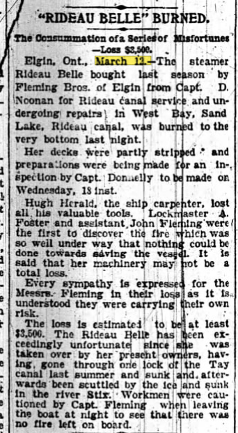
The first of the luxury steamships on the Rideau Canal was the “RIDEAU BELLE”. Built in Kingston by Robert Davis in 1885 with a single watertight deck, the 69-foot long, 15ft. beam ship was launched to carry 40 passengers. Powered by a 20 horsepower engine, Rideau Belle was to be the newest and most splendid of Victorian steamships to ply the Rideau Canal route, so much so that only after a year of service her hull was extended in length to 85ft with a new 40horsepower engine, and subsequently could now carry up to 100 passengers. The journey was a duration of 38 hours each way, in unparalleled Victorian luxury.
The interior of the Rideau Belle saw the finest cherrywood panelling adorn the dining room, velvet curtains with satin sofa lounges throughout. The luxurious Rideau Belle would sadly not operate for more than ten years when she met her fate one cold November day in 1895.
According to an article I found in the Ottawa Journal from March 12, 1895, on Page 7, it states the “THE RIDEAU BELLE BURNS”…Anchored for over-wintering in a bay of Sand Lake on the Rideau system, a fire somehow broke out and burned her hull to the waterline. The Rideau Belle met her final fate on Sand Lake and it seems her service was over, but where did she sink on Sand Lake?
FATE of RIDEAU BELLE
The 1895 article states that the luxury steamship was undergoing repairs in “West Bay” when the fire broke out, and the nearby lockmaster from Davis Lock noticed her burning. After her charred remains were left to smoulder, local legend states that the Lockmaster from Chaffey’s scavenged some of the fine cherrywood from the dining room to build his own luxury outhouse! (torn down in the 1930s)
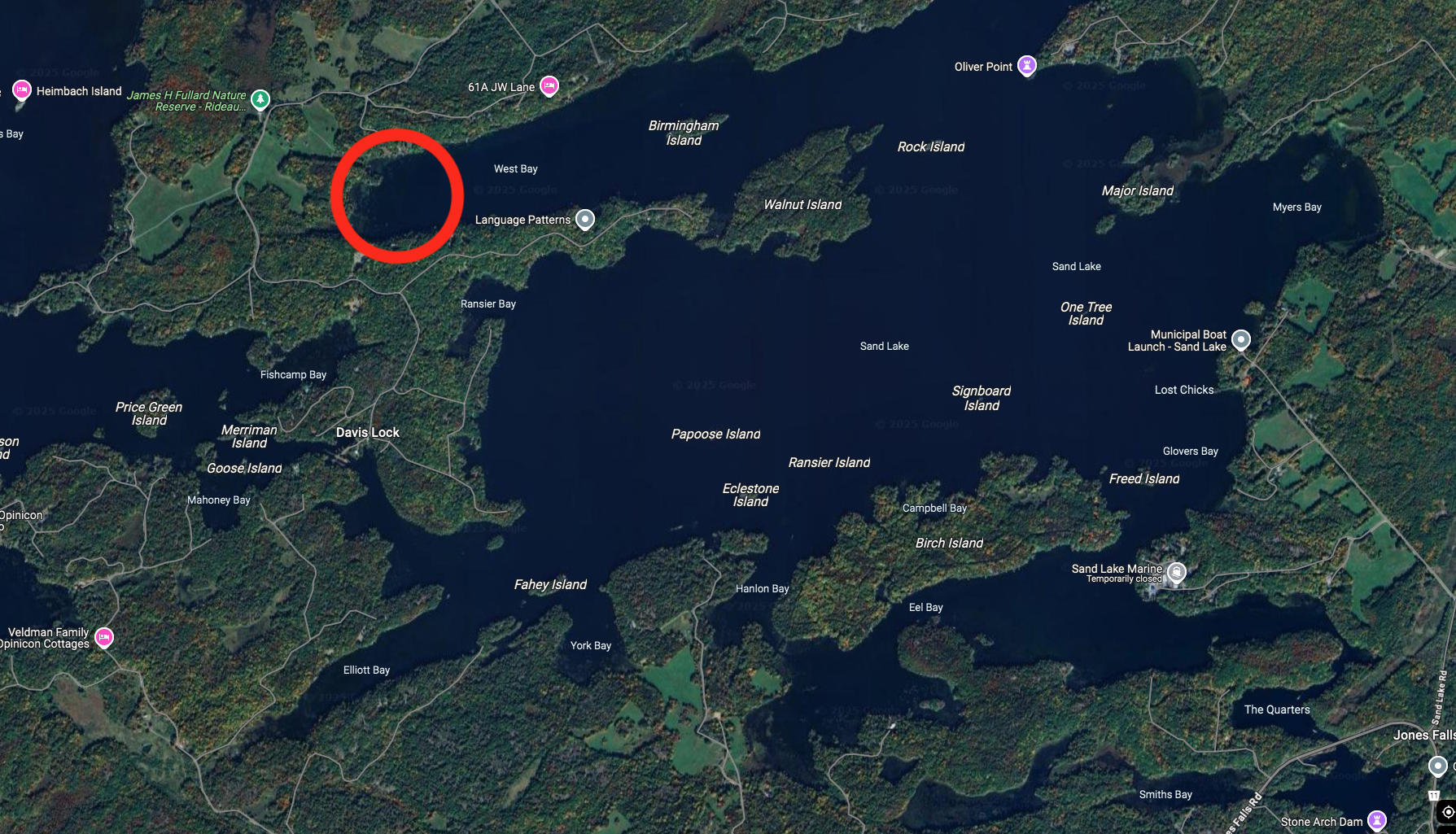
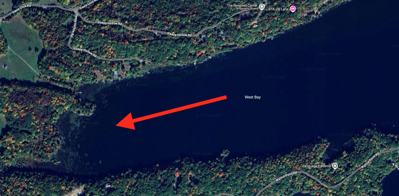
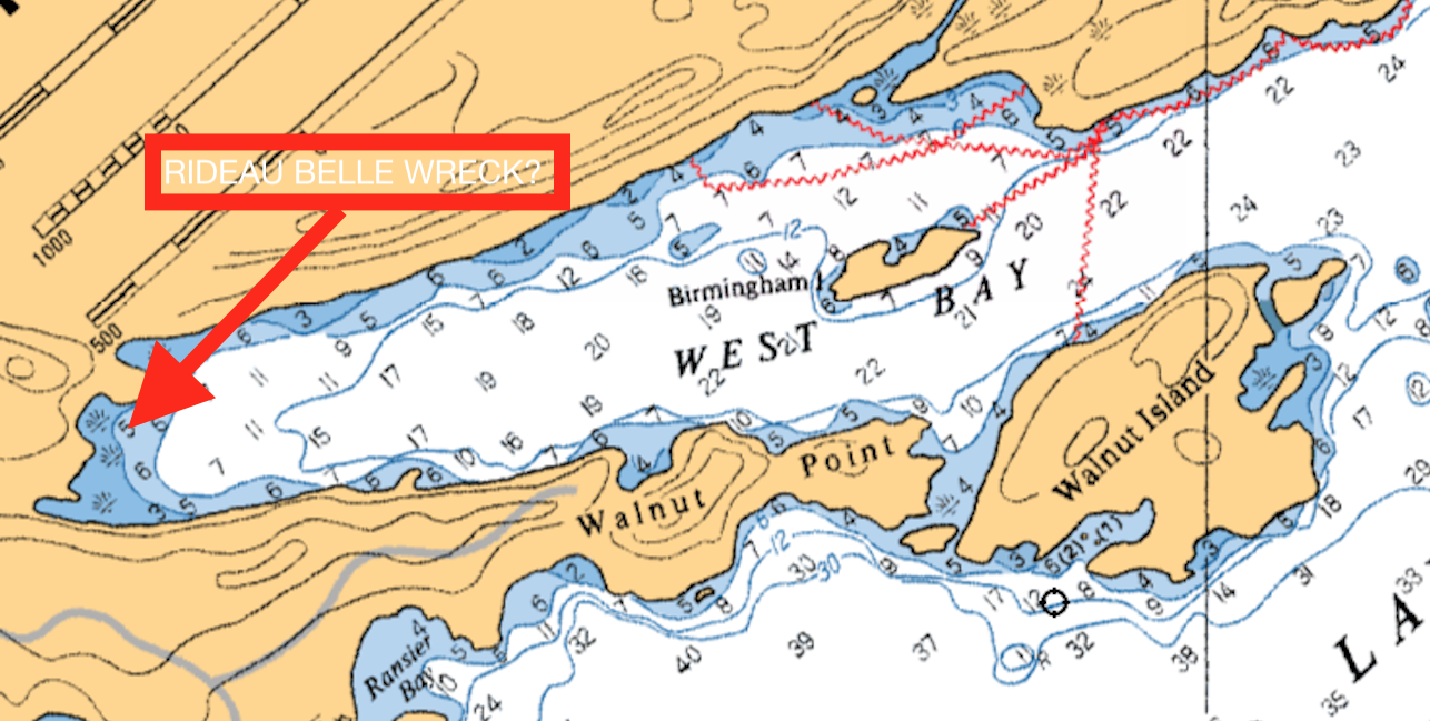
Sand Lake and the bay, West Bay, where Rideau Belle burned in 1895. (Google Maps)
So where is West Bay on Sand Lake and did Rideau Belle slip beneath the waves there or did remnants of her hull get dragged elsewhere?
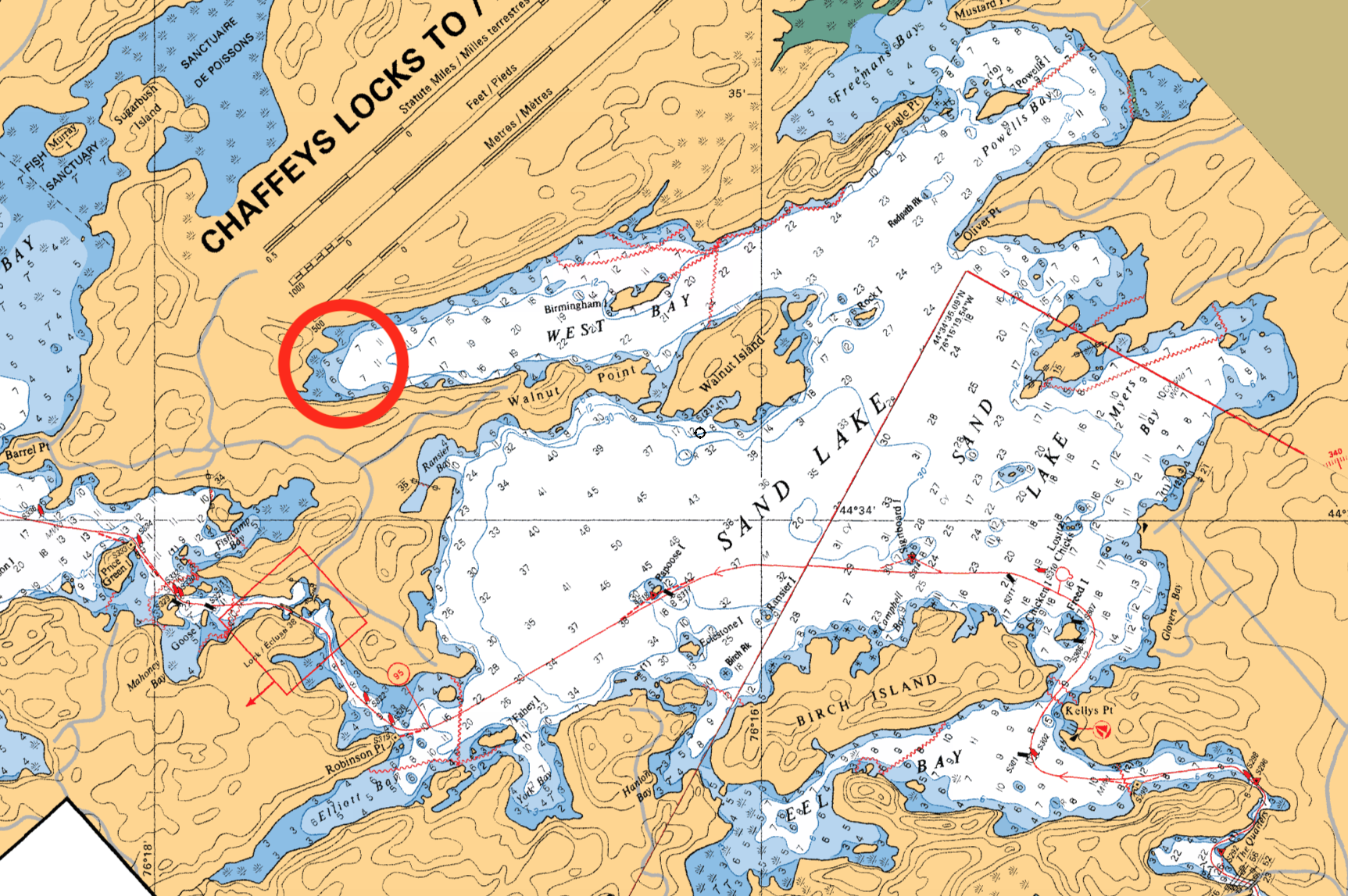
A nautical chart showing the bay where Rideau Belle burned, but no indication of a wreck marked.
A search of the nautical chart of Sand Lake and West Bay does not show any indication of a “wreck” or unusually shallow shoals that could mark the remains of Rideau Belle. Perhaps it drifted into the swampy bay of the inlet and slowly sank into the muck of the bay bottom. Perhaps a local resident from the area knows what happened to the remnants of Rideau Belle, and if it is still there waiting to be discovered after 130 years of abandonment.
THE RIDEAU KING / JAMES SWIFT
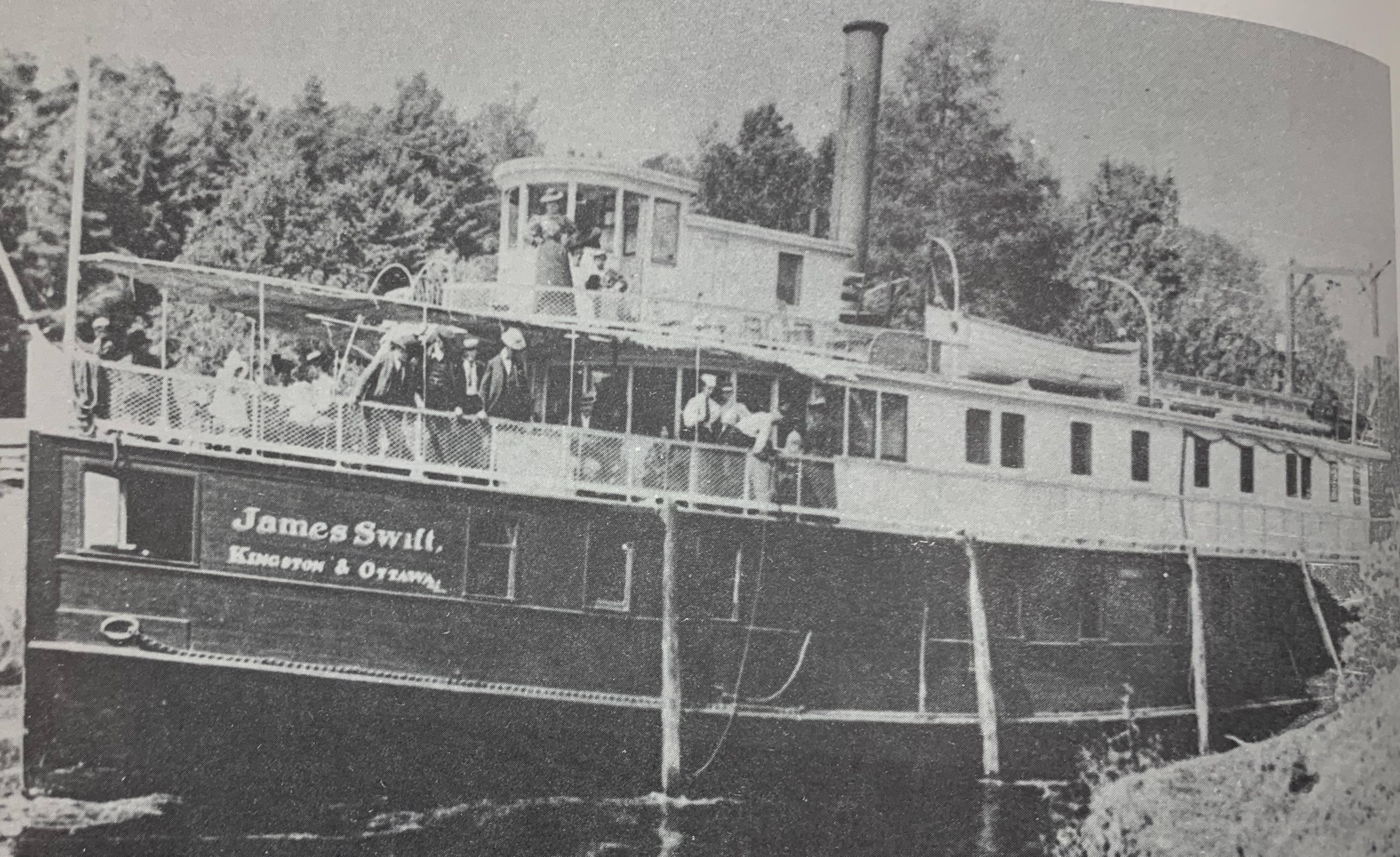
The James Swift, launched into service in 1893. (Queen’s Univ. Archives)
Two years prior to the demise of Rideau Belle, construction began in 1893 on what was to be the epitome of luxury steamship travel on the Rideau Canal: the “James Swift” . The 1890’s were a romantic period in Canadian history, and the steamship came to symbolize the leisurely and elegant way of life on the rivers and lakes of Canada. Captain Noonan wanted to ensure that his new Rideau Canal steamer would boast an opulent refinement never before experienced on the Rideau.
Built in Kingston by Matthew Davis with a length of 107 feet and a beam of 23ft., James Swift was one of the first ships to have electric lighting and a steam heating system. First licensed to carry 100 passengers, the ship also had conveniences such as hot and cold running water and made the journey from Kingston to Ottawa in about 27 hours.
With James Swift offering music and dancing at night under the moonlight as she steamed along the Rideau, she became such a popular means of travel that within only two years the ship was renovated and passenger capacity increased to 150. “Swift” made such an impression with her striking appearance and elegance that crowds of gawkers would rush to the local lockstations to take in her presence and local newspapers created headlines about the visiting steamship.
Captain Noonan and his ship James Swift was so popular that he incorporated the newly formed Rideau Lakes Navigation Company (RLNCo), and became the managing director and principal shareholder. However, it would only be 8 years later that the James Swift would almost meet the same fate as its predecessor in a tragic fire. While at dock in Ottawa in 1901, fire broke out on the James Swift, partially destroying her and killing an Ottawa fireman who gave his life trying to extinguish the fire. Robert Ireland was killed and three others were seriously burned.
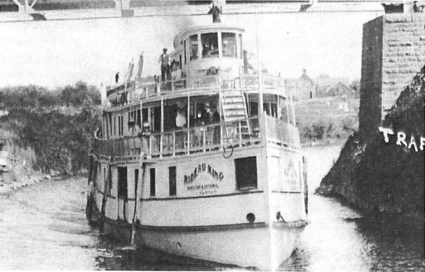
Fortunately for Captain Noonan, the hull and portions of the deck remained intact and even though the fire began in the boiler room, the Swift’s working machinery was not seriously damaged, and the damages of $2,000 was “fully covered by marine insurance”. The burnt hulk was thus rebuilt and substantially upgraded and launched again in 1902 as the “Rideau King”.
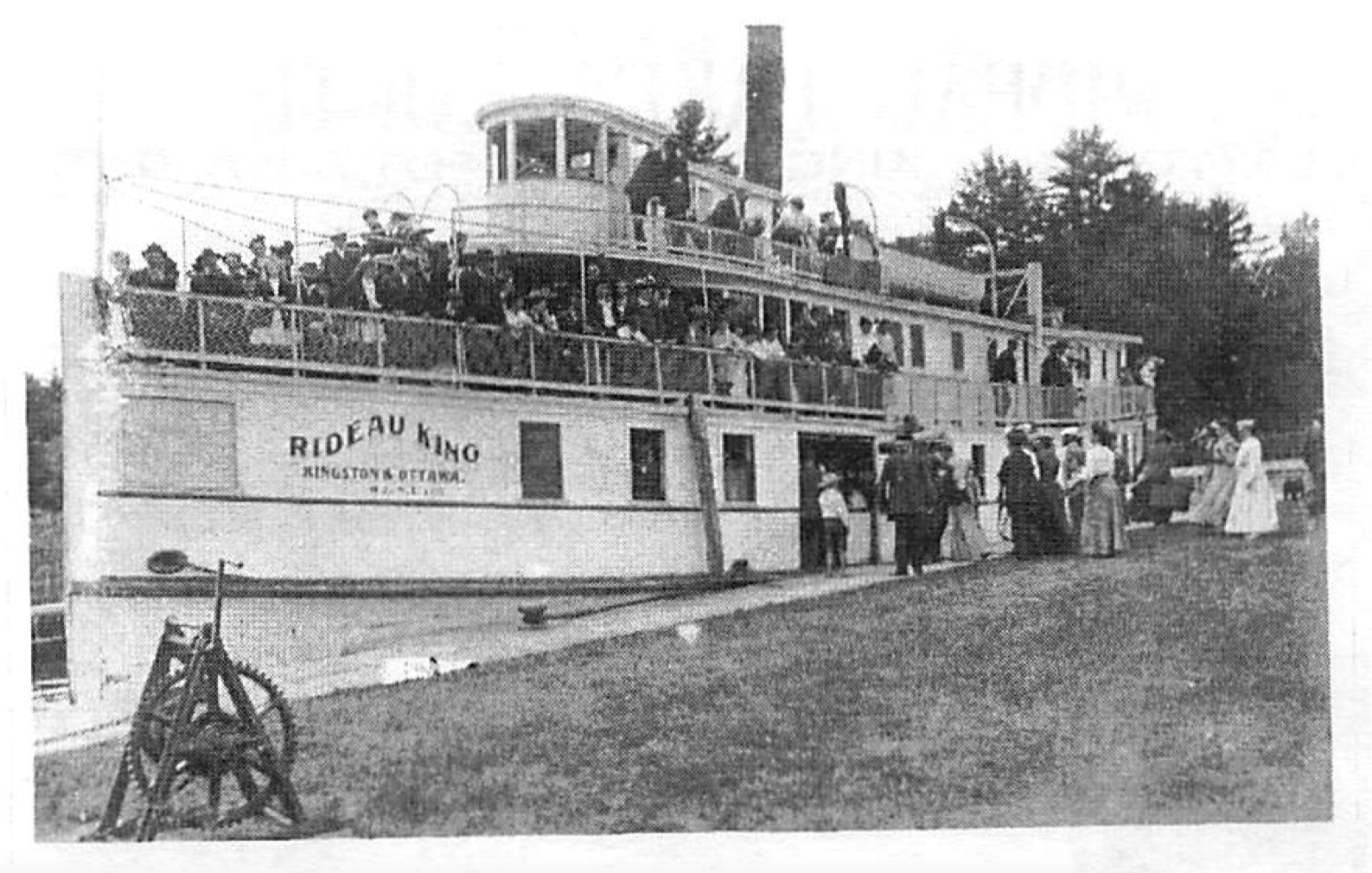
The newly rebuilt and renamed ‘Rideau King” in 1902.
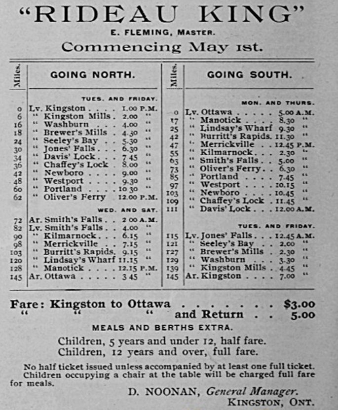
Starting services on May 1st, 1902 as the Rideau King, Capatian Noonan’s newly restored steamship offered round trip service from Kingston to Ottawa for $5.00 ($3.00 one way) with meals and berths extra, leaving Kinsgton at 1pm and arriving in Ottawa at 3:45pm the next day.
Tragedy would strike yet again in 1909 when the ship lost control and ran aground on Newboro Lake on Whitehall Island, causing $1,000 in hull damage. It was around this time that the end of the steamship popularity was becoming evident. With the popularity of the personal motorboat on the Rideau system, and the network of railways now in operation between major cities and towns, the steamship era was drawing to a close.
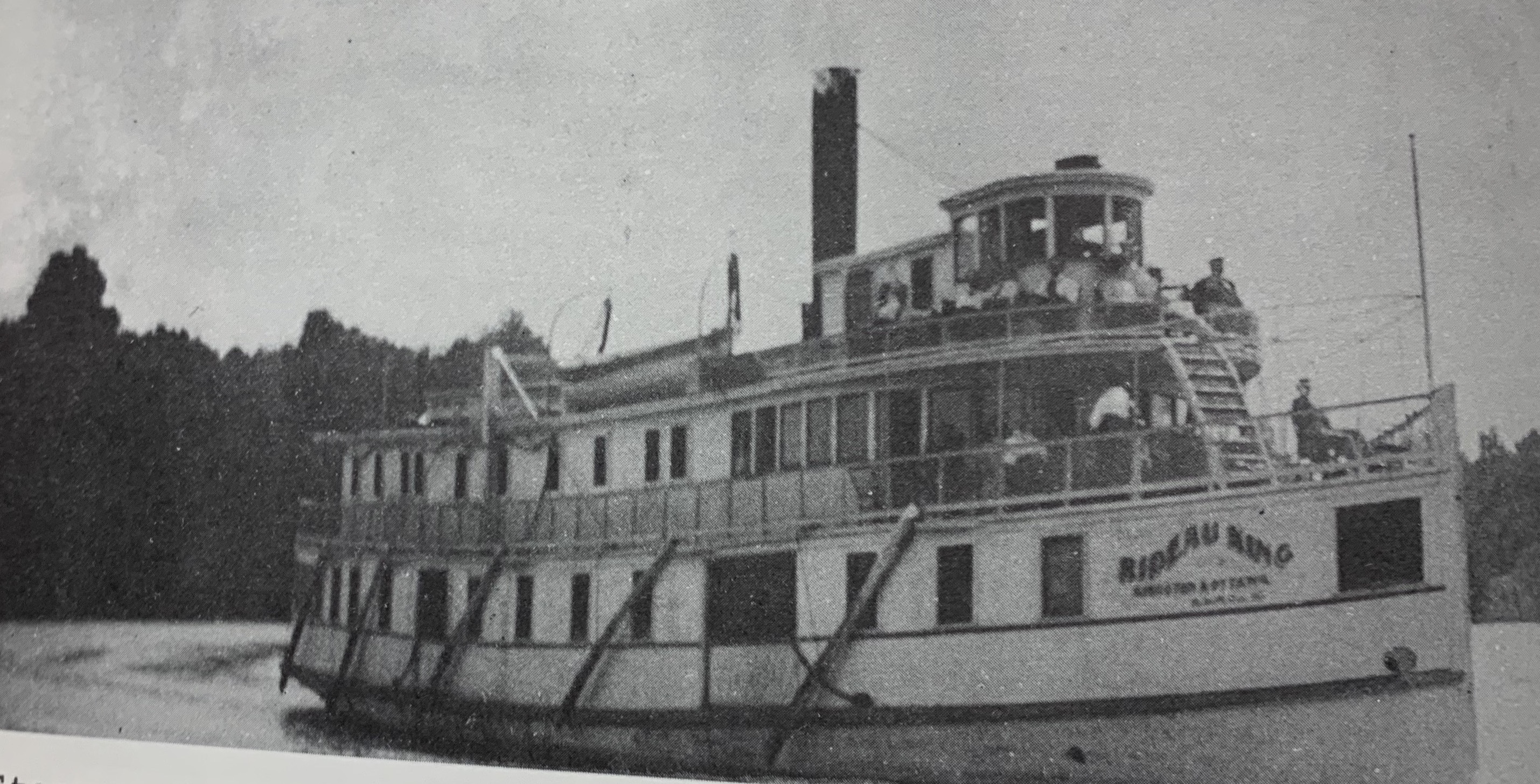
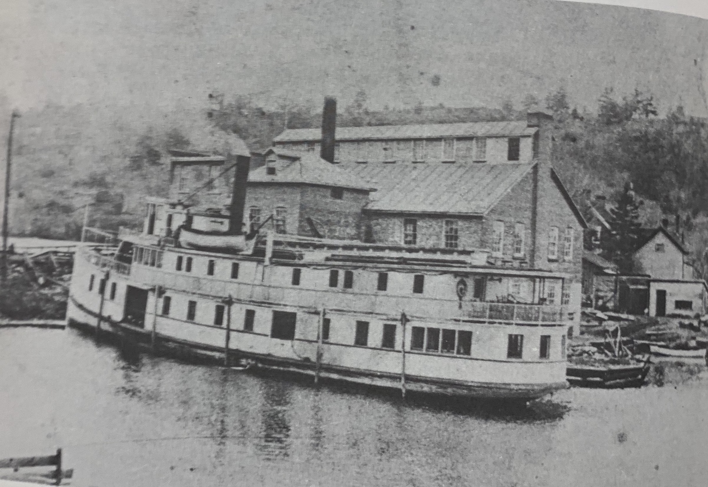
Rideau King in Westport, circa 1910. (Mr. Roberts)
FATE OF THE RIDEAU KING
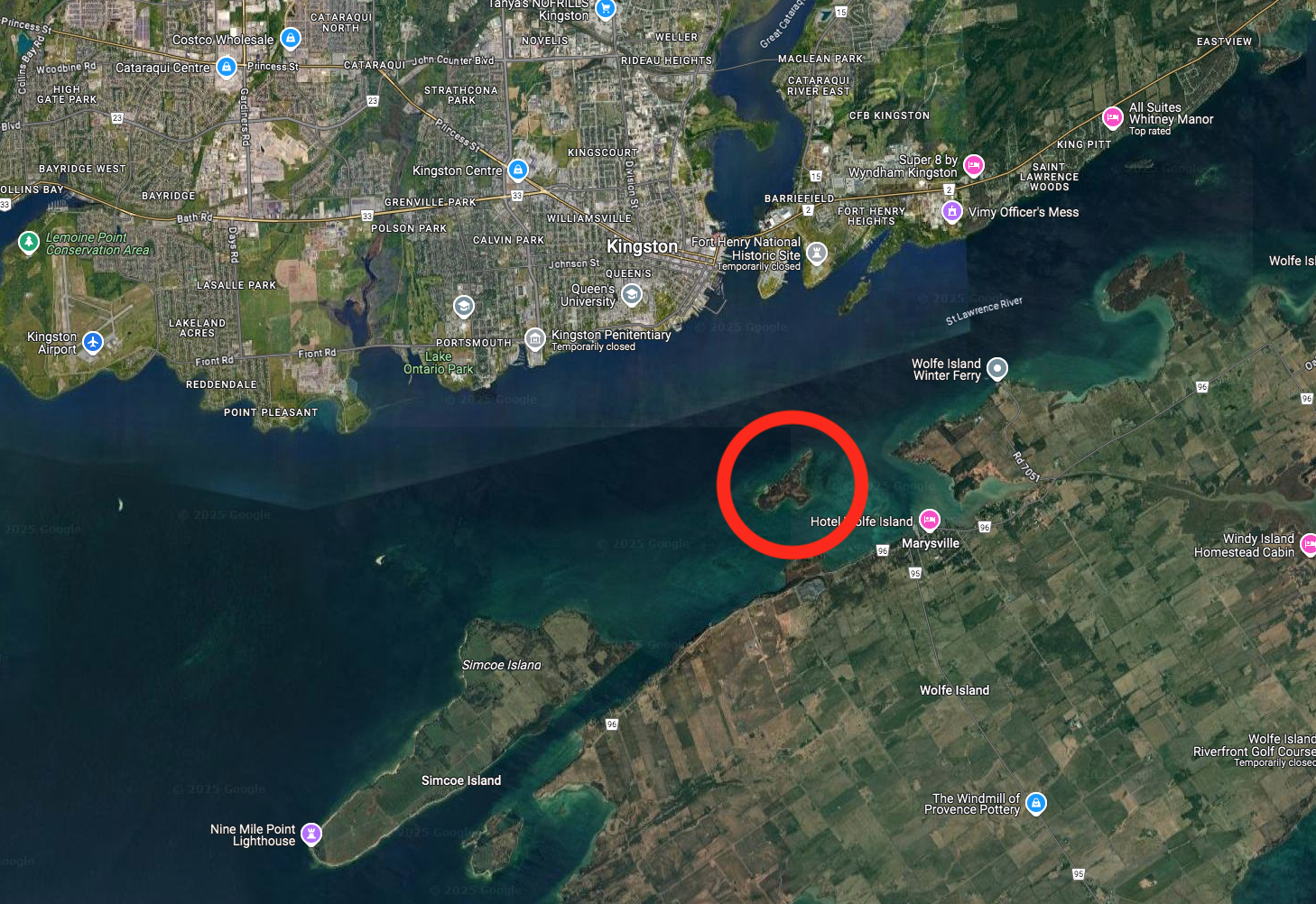
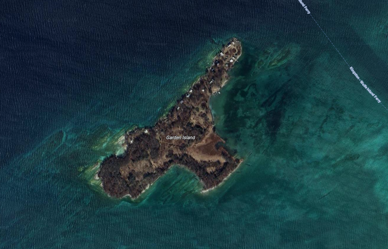
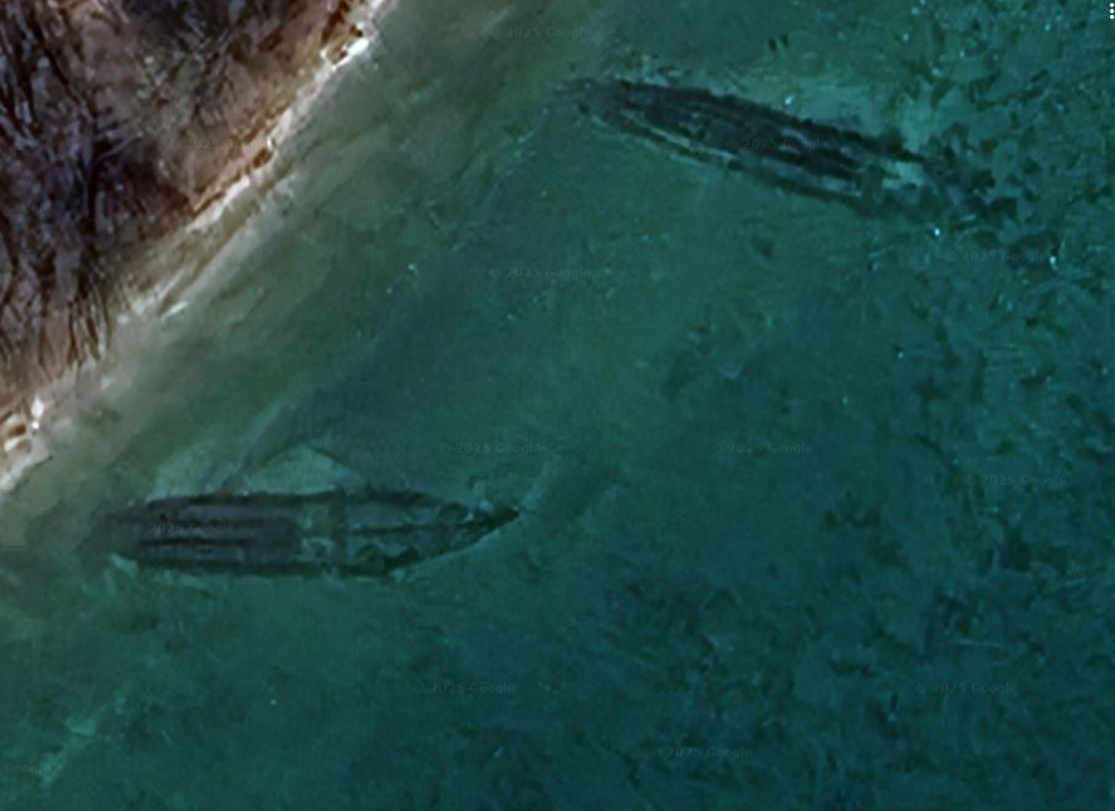
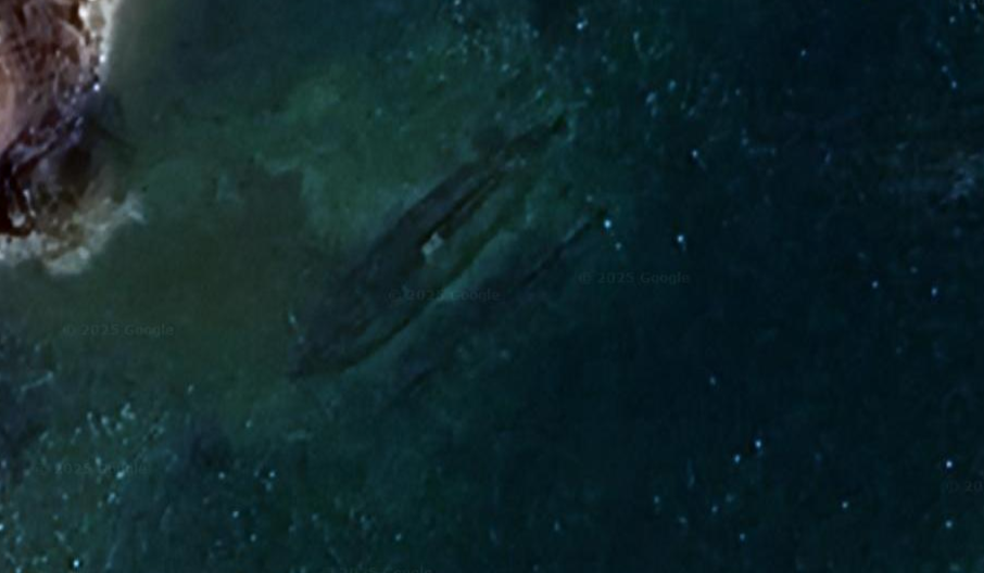
By 1912 steamship travel on the Rideau was on a serious decline and with the outbreak of World War 1 in 1914 the end of the opulence was at hand. With few passengers and a tired engine, Rideau King was still in service in 1916, but had to be removed from its duty halfway into the season on the Rideau as the ship was deemed “unsafe” since it had become “structurally unsound” with the boiler and engine requiring complete replacement. With the cost of repairs unjustified without passengers to pay for them, Rideau King ended her days being sold for scrap in 1917. After being partially dismantled for its parts, the Royalty of the Rideau, Rideau King was sunk in a lagoon off Garden Island across from Kingston, On.
Local legend states that her hull is still visible in the shallow water on a calm day, but Garden Island is somewhat of a “scrapyard of the sea” with many old ships being sunk off the island’s shores. Which of these sunken hulls is that of Rideau King?
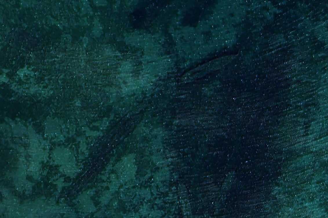
Many sunken ship’s hulls can be seen under the surface around Garden Island. (Google Maps)
Which of these sunken ships is the Rideau King?
A Google Maps satellite image of Garden Island shows many wrecks visible under the water’s surface, so without proper diving verification of hull lengths, construction details etc. it would be hard to discern which of the wrecks visible is that of the once illustrious Rideau King. (*Please let me know if you have any further info on which wreck could be it!)
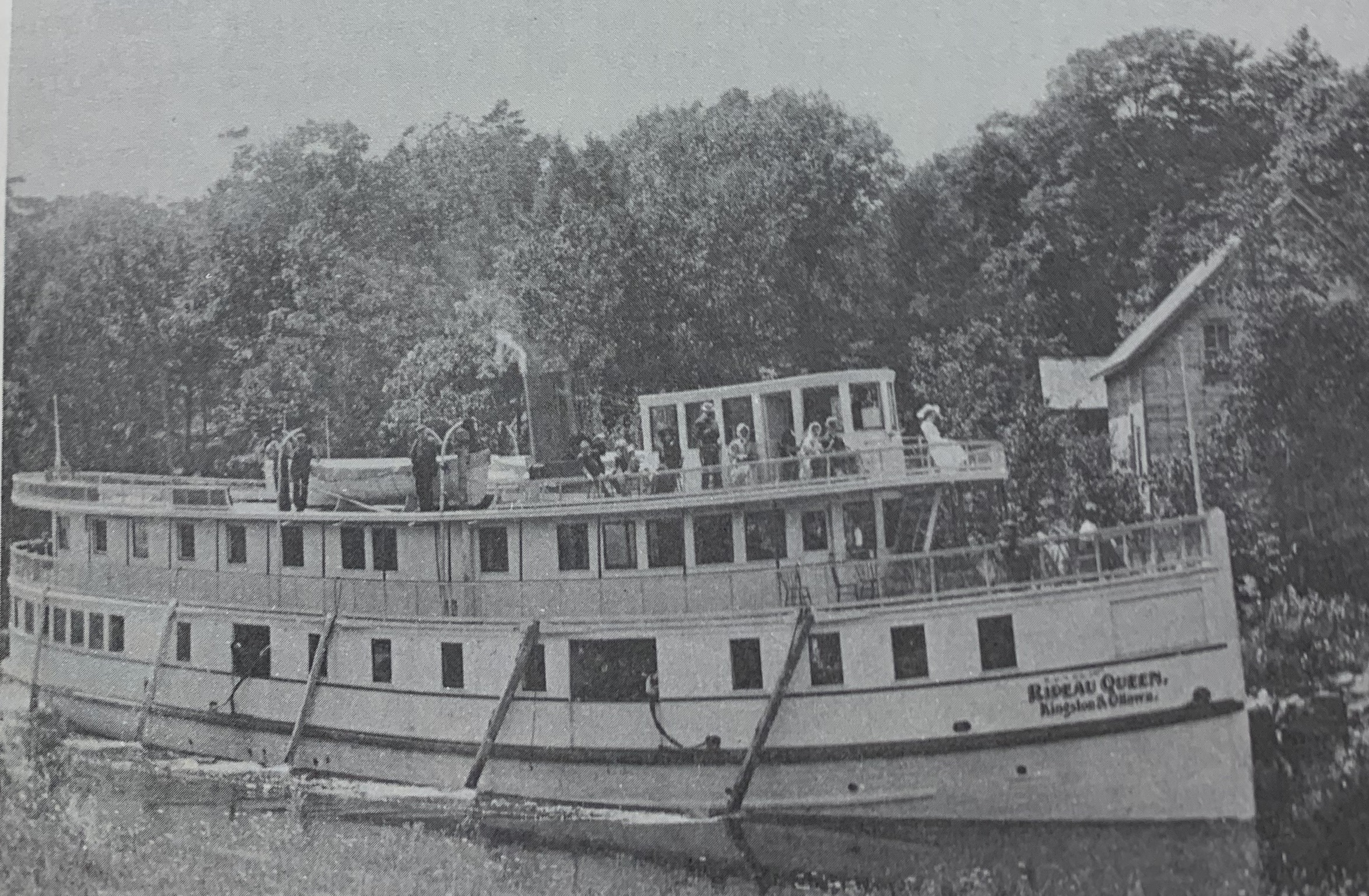
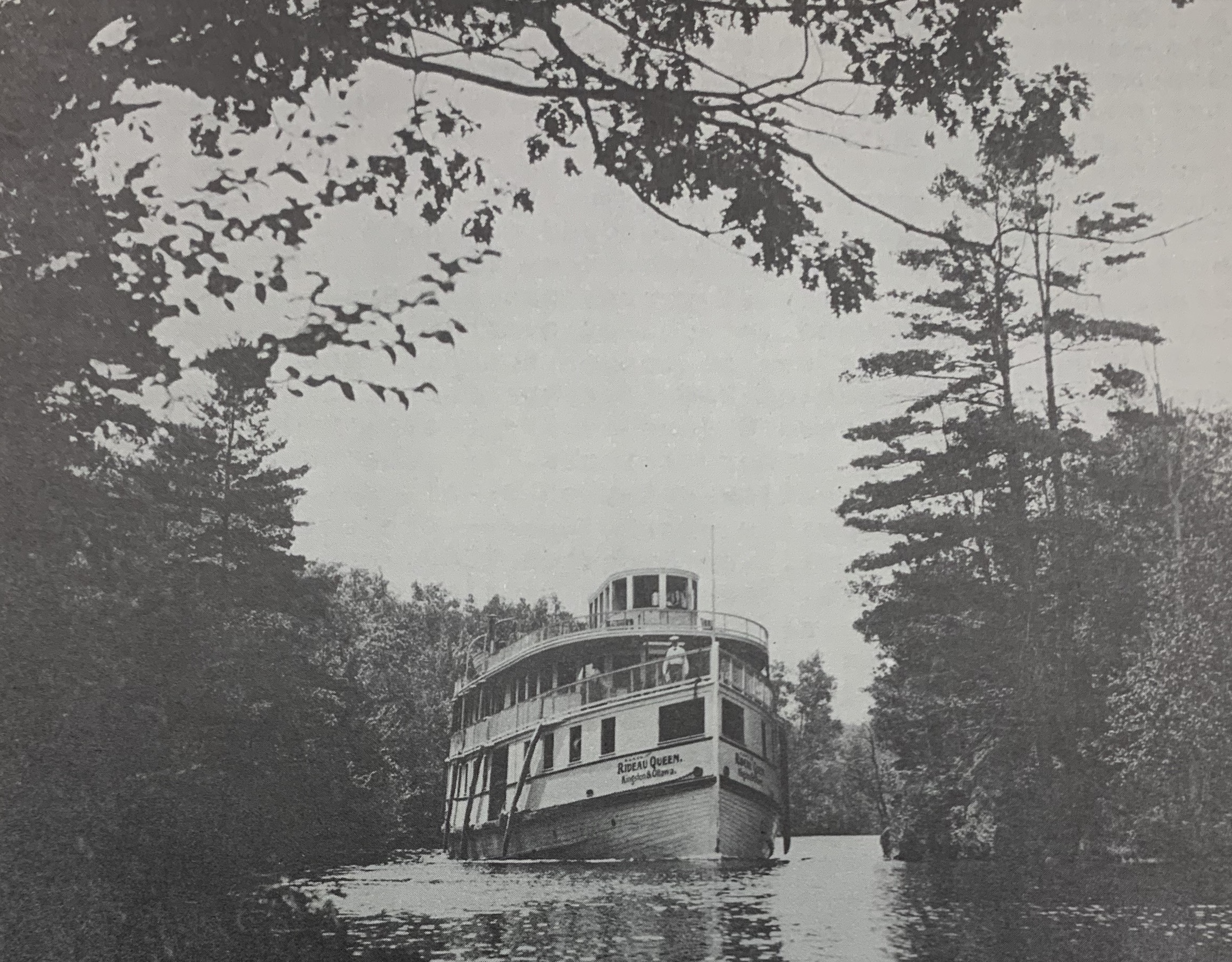
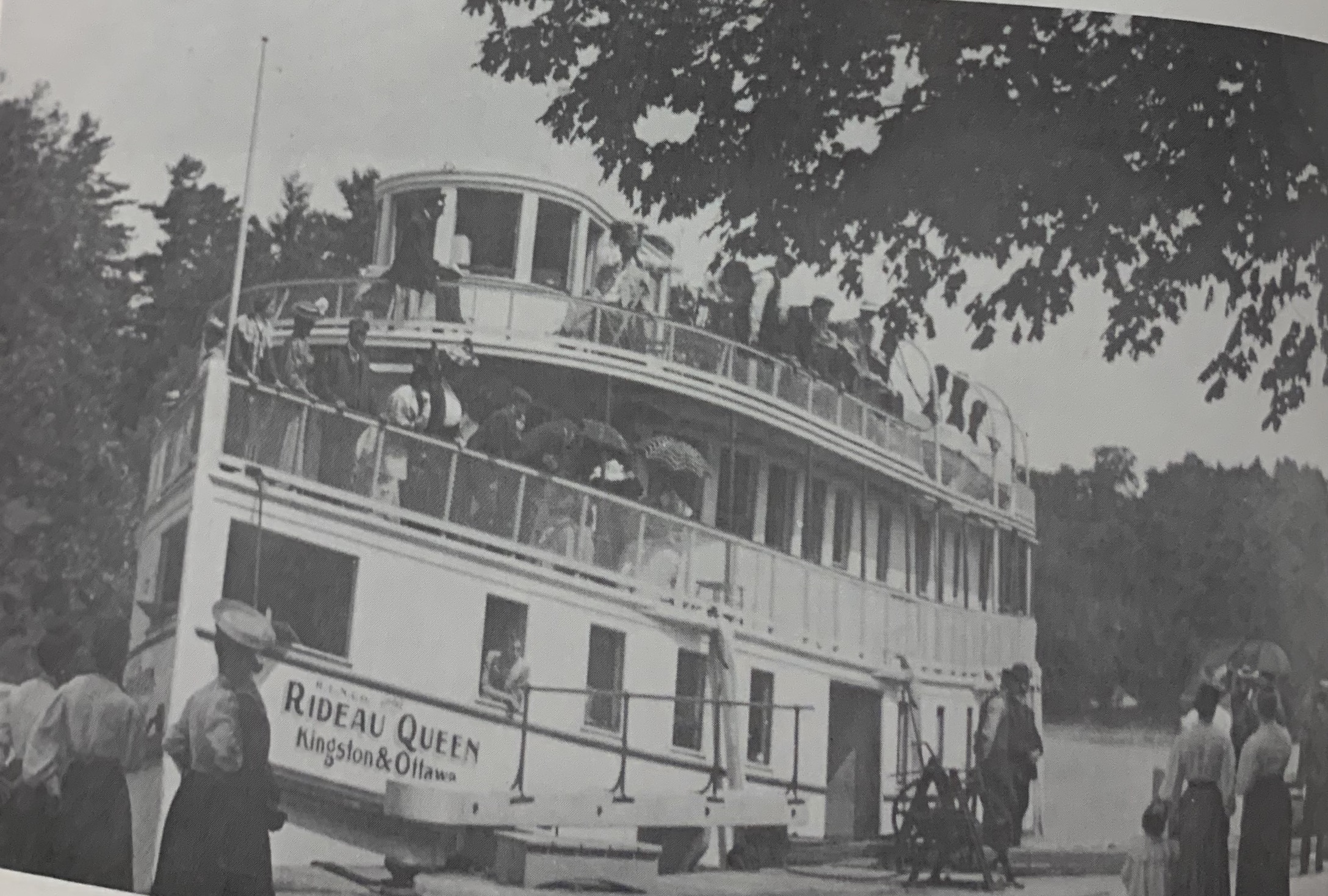
THE RIDEAU QUEEN
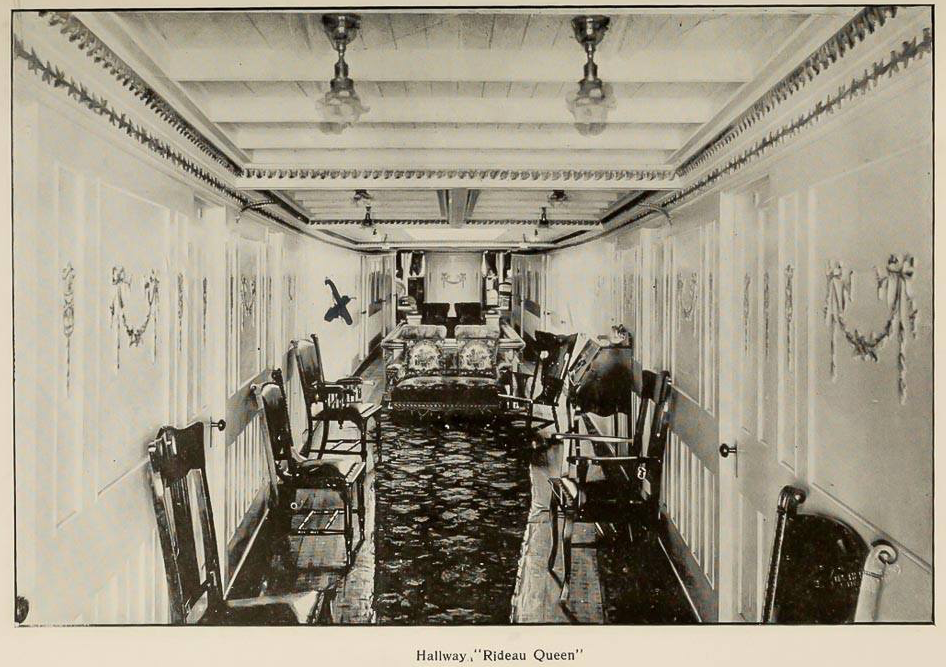
The Rideau Queen at Chaffey’s Lock,
During the success of Captain Noonan’s Rideau Navigation Company at the turn of the century, he and his company was doing so well with the steamship service on the Rideau Canal that he commissioned the construction of another steamship in addition to his Rideau King...The Rideau Queen.
Also built by Robert Davis in Kingston, the Rideau Queen entered service in 1900 at a length of 108ft. and a breadth of 24ft. The most luxurious of all the Rideau steamships the Queen was ready for 300 passenger service in June of 1900, boasting accommodations rivalling any hotel of the time.
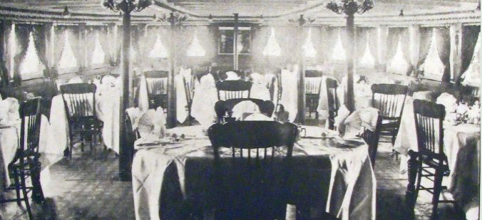
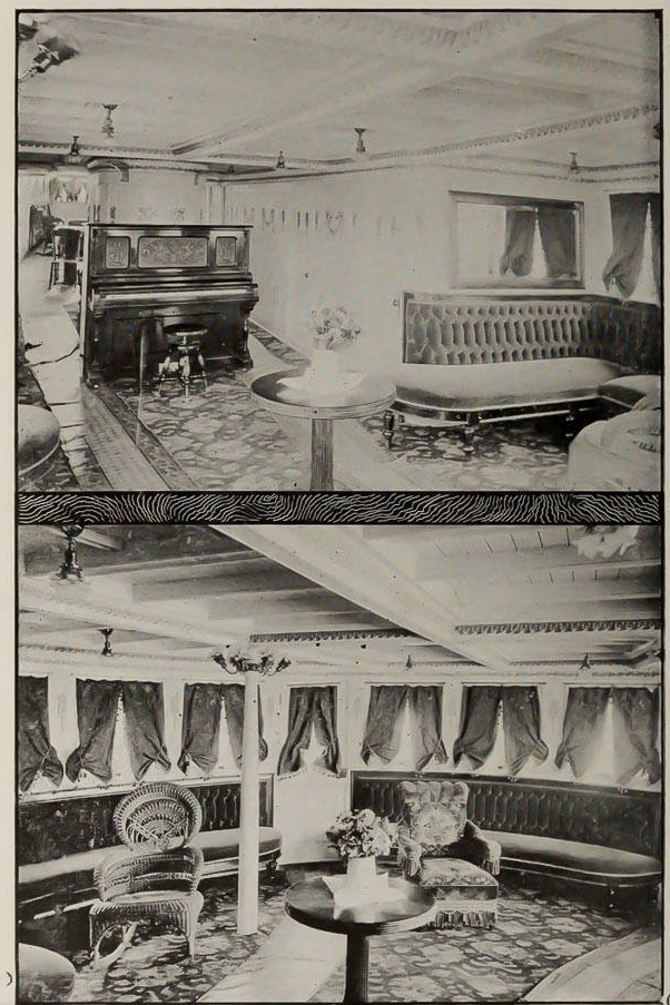
The dining room aboard Rideau Queen.
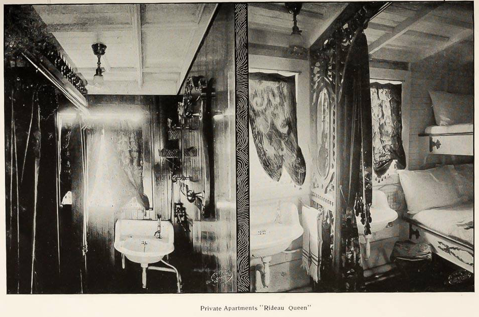
Ads in newspapers would boast that the latest Rideau steamship had “steam heat, electric lighting, electric fans, and cabins priced from $1.00 to $5.00, with meals at 50cents, and “lavish marble wash basins”.
Interior images of the Rideau Queen’s lavish interior.
Thousands of passengers boarded the Rideau Queen, with many amplifying local economies along the Rideau Canal route it took, with many towns benefiting from its stops along the way between Ottawa and Kingston.
Word spread to America of the Queen’s journey, with many American tourists taking the train from New York City to Ogdensburg or Clayton, New York and across the St. Lawrence River for service to Ottawa along the picturesque Rideau Canal.
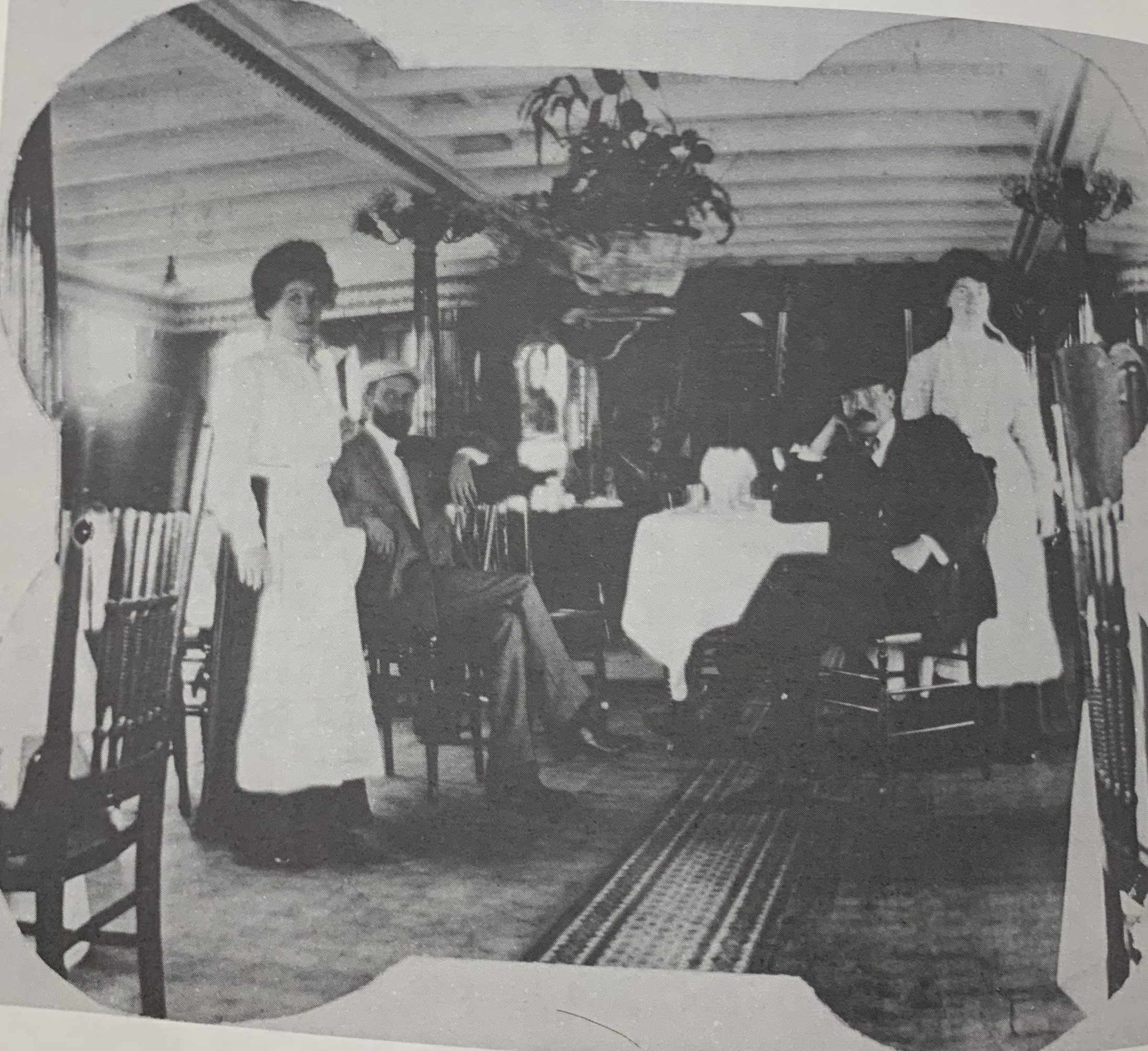
Aboard the Rideau Queen.
However, all good things must come to an end, and in 1912 steamship travel began its death spiral, and in 1914 there was a transition from happy recreational activities like boating to the war effort of World War 1 that brought an end to such luxurious folly.
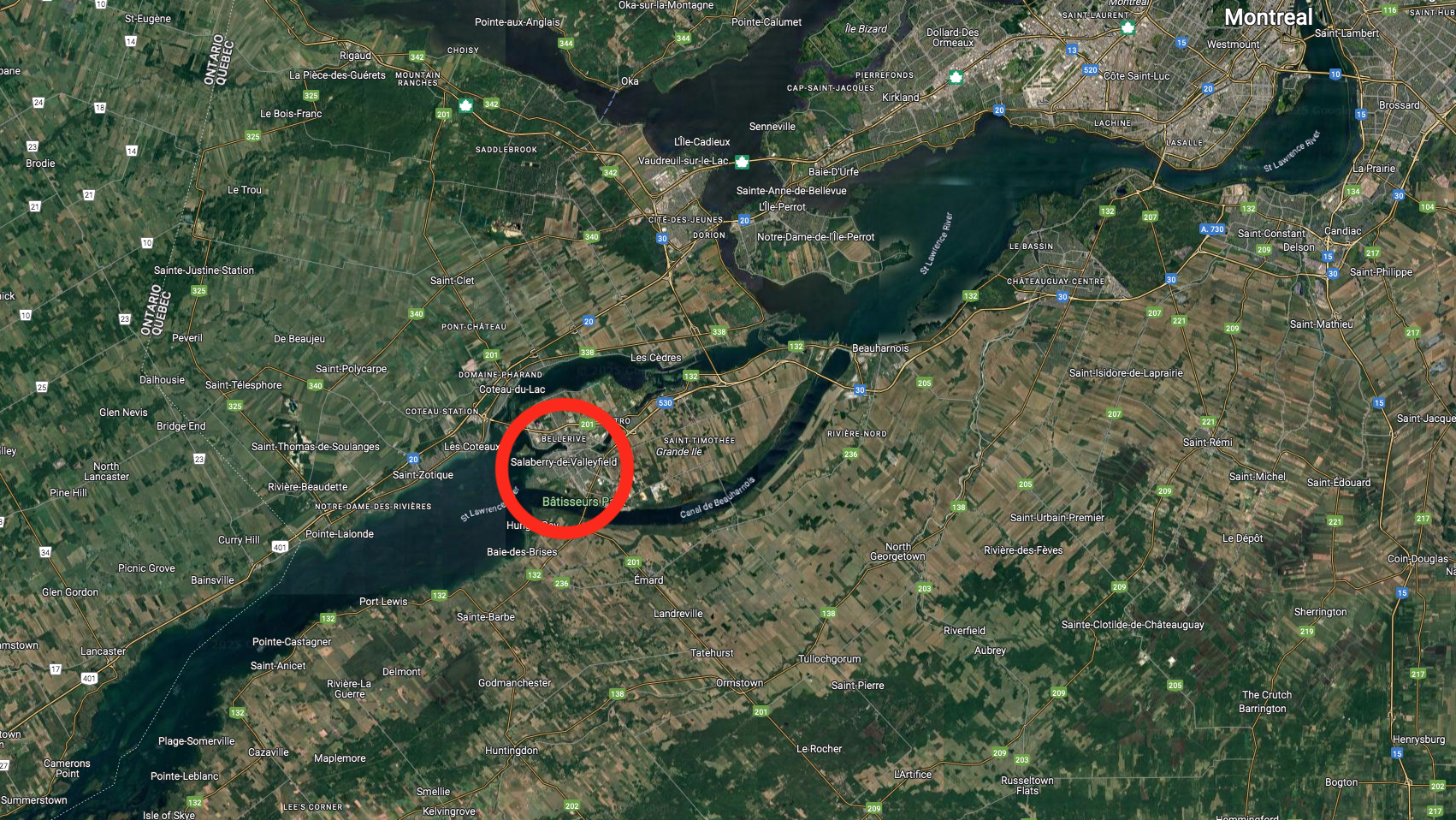
On top of the Great War destroying business, Captain Noonan died in 1914, and with it his glorious steamship business. Like the fate of Rideau King before it, Rideau Queen was sold off to new owners, the Trent Navigation Company in 1916 where she plied the waters of the Bay of Quinte doing contract work. Then in 1922 Rideau Queen was sold to a Mr. C. Leboeuf and Mr. Gobout of Valleyfield, Quebec. In 1924 she was sold to the Valleyfield Transportation Company to be used as a cargo vessel on the St. Lawrence River.
With an illustrious past as a luxury steamship on the Rideau Canal, Rideau Queen sadly saw her last days on the water as a cargo barge before being hauled ashore and demolished somewhere in 1933…location unknown.
FATE OF RIDEAU QUEEN
With the whereabouts of the Rideau Queen not known with any exact certainty, one could speculate that the Queen was laid up somewhere near her last area of service, which was Valleyfield, Quebec. I am not familiar enough with Valleyfield to know where the ships would have been at port, or dismantled, so if anyone knows anything about the Rideau Queen being in Valleyfield, Quebec, please let me know!
Rideau Queen’s last known location, southwest of Montreal.
CONCLUSION
It seems rather sad that the era of luxury steamship travel on the Rideau system only lasted 20 years, from 1895 to 1915, the glory years of a lavish steamer experience likely never again to be replicated. With their opulent accommodations and slower pace style, these three steamships represent a lost method of traveling between Kingston and Ottawa that was both unique and impressive.
The three main steamships are now lost in time, relics of a forgotten era in steamship transportation that now has no physical connection. Perhaps one day the remains of them will be found, the Rideau Belle somewhere in a bay of Sand Lake, The Rideau King somewhere off Garden Island and the Rideau Queen in pieces somewhere near Valleyfield, Quebec.
Until that time we can only imagine how that journey must have been like under plumes of smoke above your head and wooden hulls gently slicing the waters of the Rideau Canal System over a century ago.
THE TRAGIC CRASH OF A WW-2 BOMBER IN A MANOTICK FARM FIELD
After World War Two ended in 1945, many of the aircraft that were in service moved on to other roles in the 1950s. This included the North American B-25 Mitchell, an American medium bomber that was introduced in 1941 and used by many Allied air forces during the war. The B-25 served in every theatre of World War II, and many remained in service in the post-war period.
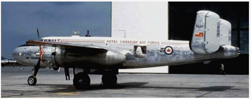
A B-25J similar to the one that exploded over Manotick in 1957. (SilverHawk.com)
One such B-25 was number 5215 in service with the Central Experimental and Proving Establishment, or CEPE, which was formed in 1951 by amalgamating Ottawa operations at Rockcliffe, the Winter Experimental Establishment in Edmonton, and the R.C.A.F. (National Research Council) Unit in Arnprior. Headquarters of CEPE were at Rockcliffe in Ottawa, with detachments at several sites across Canada. In 1957 CEPE was moved to RCAF Station Uplands also in Ottawa, a move necessitated by the longer runways required for testing new jet aircraft.
A B-25 at Rockcliffe Air base in Ottawa. (SilverHawk.com)
The CEPE tested captured German rocket planes like the Messerschmitt 163 KOMET in Arnprior which was covered in a previous article here. It would be in the same year that the CEPE was moved to Uplands that a tragic and still unsolved crash killed 8 people aboard the B-25J in Manotick, Ontario.
A B-25 in RCAF service like the one that crashed in Manotick. (SilverHawk.com)
On March 1st, 1957 B-25J 5215 that had been modified to carry passengers instead bombs was completing a flight from Churchill, Manitoba to Ottawa with a fuel stop in North Bay, ON. Previously, the aircraft was part of the United States Air Force, built in 1944 during World War 2 with serial number 44-30485. Received from the USAF at Mobile, Alabama it went into storage with Training Command at RCAF Station Saskatoon, Saskatchewan in December of 1951. It then went to Advanced Flying School at Saskatoon in January 1952, then to North West Industries in Edmonton, Alberta for modifications in 1952/53. The modifications made included avionics upgrades but there is no mention of engine modifications that may have led to its demise.
With bad weather engulfing the Ottawa area that night, the B-25 was advised to land at Uplands instead of Rockcliffe. As the plane made its descent to land at Uplands, it suddenly and unexpectedly exploded in mid-air, with a blinding white light flashing over the small village of Manotick southwest of Uplands airfield.
Witnesses in Manotick said that the plane was sputtering and then in blinding flash, exploded in mid-air, hurtling to the ground and exploding in a second fireball that rained aircraft fragments throughout the farm field where the tragedy occurred. Eight people aboard died that fateful night in 1957, including Air Vice Marshal Robert Ripley, Commander of the Air Material Command. Also lost that night in the explosion were:
RCAF Leading Aircraftman Kenneth Oliver Doerksen RCAF Wing Commander James Garvin Easson DFC RCAF Corporal Ronald Wesley Faulkner RCAF Leading Aircraftman Joseph Maurice Gauthier RCAF Wing Commander Walter Sherwood Johnson RCAF Flight Lieutenant John Douglas Mawson DFC
Lt. Commander Henry F. Utting, Naval Testing Detachment
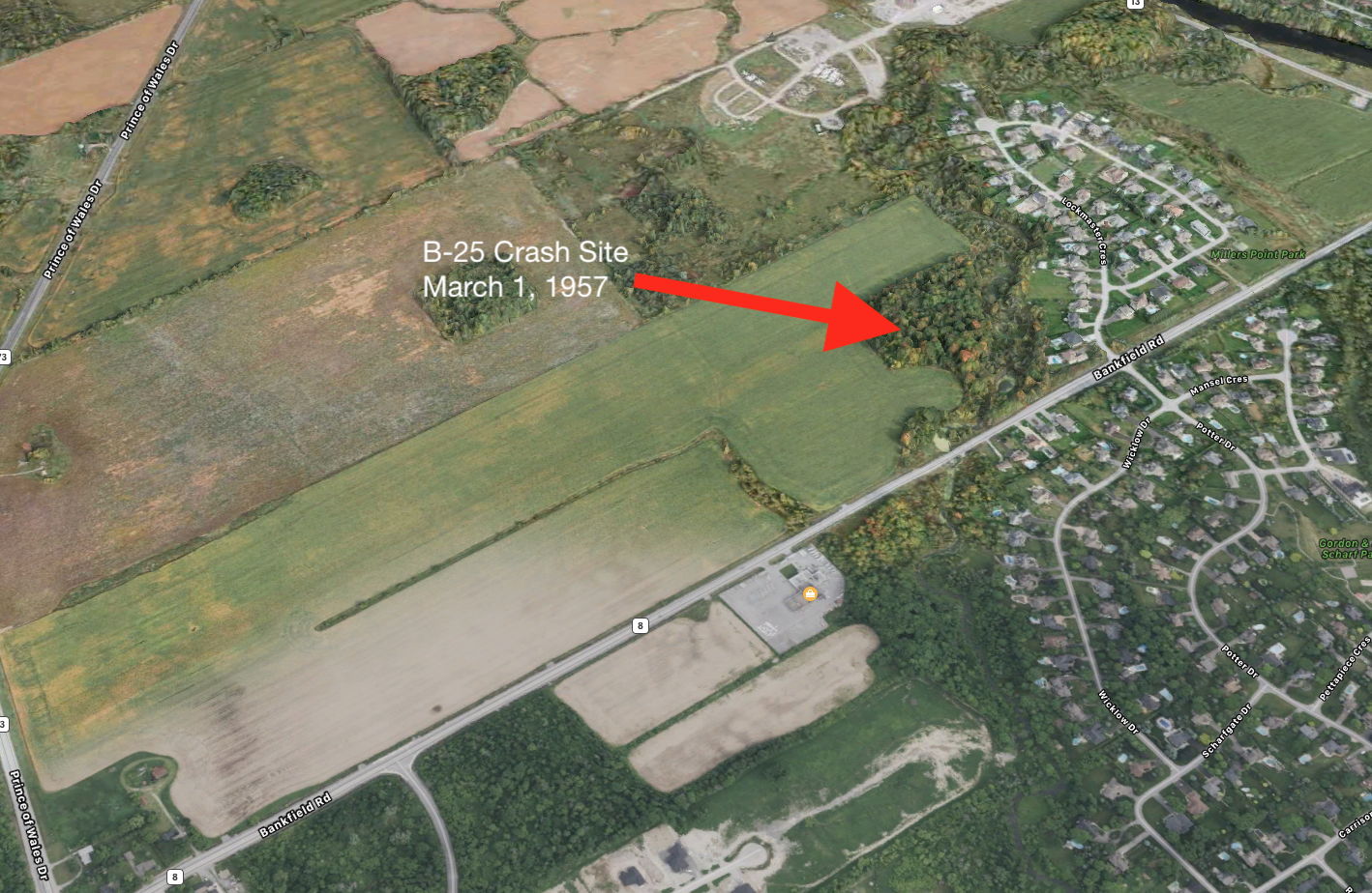
The aircraft explosion sent wreckage across the farm field of Thomas Watts, whose field was on Bankfield Road across from the Rona that is there now. The violent force of the explosion sent parts flying into the powerlines of Manotick causing a brief power outage, but of the utmost macabre was the fact that the body parts of the crew members were found all throughout the farm field and in the trees along the nearby creek.
The flaming wreckage set fire to the trees and soon RCAF officials arrived to contain the chaotic scene. Plane parts were imbedded into tree trunks, the creek bed strewn with wreckage. Investigators into the crash could not determine the cause of the tragic explosion, and it is not known to this day why it exploded into a ball of white light on approach to Uplands Air Base.
WHAT’S LEFT?
Sixty eight years after the tragedy, nothing marks the spot where eight men lost their lives, no plaque or any indication of what exploded over Bankfield Road that fateful night. A quick Google Maps search reveals the exact location of the crash site, but does anything remain from the B-25 bomber in the ground or in the creek where it happened?
The location of the 1957 B-25 crash site. (Apple Maps)
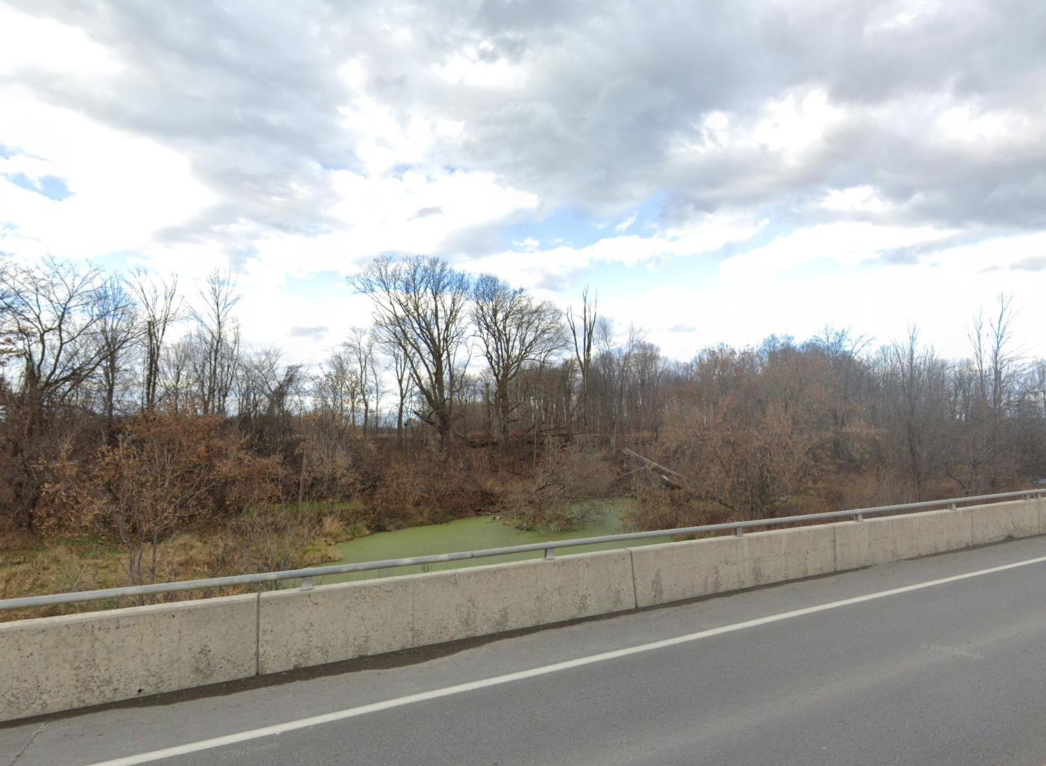
A search and sweep with a metal dectector might turn up pieces of the plane and other relics of this lost aircraft. A quick walk around the site definitely provided an assessment of the dense wooded area and creek where the aircraft wreckage was said to have crashed.
The crash site off Bankfield Rd. near Manotick.
FURTHER INVESTIGATION
Without permission from the land owner whose property may contain lost wreckage from the B-25 bomber, it will be difficult to venture forth with a metal detector to see what, if anything, lies buried in the ground from this crash. With the 70th anniversary of the tragic incident approaching in 2027, it might be time to now pursue possible further investigation, or at least get the ball rolling on a commemorative plaque possibly being placed nearby as a memorial to the eight souls that perished that terrible night in 1957.
The B-25J currently in flying condition with the Canadian Warplane Heritage.
I would like to call upon the City Of Ottawa, the RCAF, The Local Manotick Brach of the Legion and maybe the Canada Air and Space Museum to assist in an investigation to recover and respectfully remember the B-25 crew lost that night. I would also like to advise the Canadian Warplane Heritage Museum that operates a flying condition B-25J to possibly consider doing a commemorative flypast over the site in 2027 to mark the 70th anniversary of what I would call the….Mayhem Over Manotick.
The year is 1854 and eight years prior, The Smithsonian Institution was formed in 1846 as a group of museums, education and research centres, created by the U.S. government “for the increase and diffusion of knowledge”. It still operates as a trust instrumentality and is not formally a part of any of the three branches of the federal government.
The Smithsonian Institution “Castle” built in 1849.
A representative from the Smithsonian, a Mr. Guest is sent to Canada, specifically Prescott, Ontario to investigate what seems to be a large earthworks formation resembling an ancient fort. Mr. Guest arrives from Ogdensburg, NY. He describes the first site as being “eight miles and a half northwest of Prescott” and containing “mounds and embankments.” He then mentions the presence of four mounds arranged in a rectangle formation, which contain between one and two acres of ground. He says the mounds were up to four feet high. Guest sketched the formation:
Mr. Guest’s 1854 map sketch of the formation.
Guest’s map shows what he describes as “a half moon embankment, extending some ten rods across a neck of land, terminating to the north in a swamp, and to the southwest near the edge of a creek. It has three openings, which are from twenty to twenty-five feet wide.
Guest believes the entire “island” of land was artificially constructed out of sand and notices charcoal and ashes; and human bones, pointed bones from the leg of the deer, horns and skulls of the same animals, human skulls and bones of the beaver” as well as: A walrus tooth pendant. Curious, because the Prescott area is not known for its walruses…
A Walrus Tooth Pendant, similar to the one found by Mr. Guest.
So where exactly is this earthworks formation that the Smithsonian sent Mr.Guest to investigate in 1854? Well, taking the distance Guest mentioned of 8.5miles NW of Prescott, we can set up a general vicinity.
The general area that Guest describes northwest of Prescott.
This is remarkably close to another curious site that turned up an unusual European made 15th-16th century bone needle case back in a 1912 archeological dig.
A machined bone needle case of European manufacture found near this site in 1912. (Canadian Museum of History)
I was able to access the LiDar imagery data of that particular area and transform the map to a surface detail map to see what kind of topography exists and if anything resembles the “island fort” Guest discovered.
Studying that area Lidar imagery it appears we have a very close match to Guest’s 1854 investigation map, although a modern road has been constructed through its western arm:
To confirm this was the site investigated by Guest, I overlaid a ghost image of the fortress sketch on top of the Lidar image… It’s a pretty good match…
Ok, so we have some kind of earthworks here to investigate…I am familiar with this site, having been introduced to an unusual archeological find here discovered in 1912. An archeologist by the name of Mr. Wintemberg discovered a piece of “carved bone,” that he described as “suspiciously European.” This suspiciously Out Of Place Artifact was then stored away in the Museum of History warehouse where its origin remained a mystery…and its research data has since been removed from the museum database.
Luckily I don’t rely on the Internet for everything and I have acquired the original 1912 archeological report:
And using this report we can get a sense of where and what was found here… Burials. Objects. I can even trace back to 1912 photographs of the site and the massive excavation of this earthworks…
Objects recovered in the 1912 archeological dig. (Wintemberg report)
So what was this unusual structure and who built it? It seems the 1912 report doesn’t really know, but attributes it to the St.Lawrence Iroquois. “AGE OF THE SITE The age of the site is unknown and there is no positive evidence pointing to its great antiquity”
Site excavations in 1912. (Museum of History)
I saved the recent report about the European bone needle case found there in 1912, which states that according to former Curator of Central Archaeology at the Canadian Museum of History, Jean-Luc Pilon, the curious bone object was studied in detail and using a small sample taken from the odd cylindrical object & was carbon dated with an accelerator and mass spectrometer. The final results of the dating put the oddity at a date of between 1499 and 1578…and was determined to be a European machine lathed bone needle case for metal sewing needles. Wait, how did a European lathed bone metal needle case get into these earthworks far before Europeans were in the area?
Screenshot of Museum Of History website catalogue.
One answer could be that the object was traded between tribes and made its way from the East Coast of North America in the 1500s all the way to this site south of Ottawa. Another theory is that a new European visitor made their way to the site, maybe a lost a castaway from a European expedition, or perhaps an expeditionary group using smaller boats came into the area and left behind objects of their making. The object was found among other dated Iroquois objects of the time which ruled out it was dropped there at a later time. Whatever the “case” may be, literally and figuratively, this object is truly an Out Of Place Artifact, as the indigenous people of that time had neither lathes or metal needles.
Further examination of the Lidar imagery shows that the original earthworks formation studied by the Smithsonian’s representative, Mr. Guest has been partially destroyed. (Note the crater at bottom) Perhaps from the 1912 excavation?
ANCIENT EARTHWORKS A CELESTIAL OBSERVATION STRUCTURE?
Was this structure an Archaeoastronomical Complex…?
The unusual layout and odd diagonal embankments reminded me of other ancient structures aligned with the Spring Equinox and Summer Solstice…like the ancient mounds in Ohio and the Serpent Mounds. I applied the Sun Surveyor app to the structure and it seems to lean in that direction. The embankments of lines in straight and diagonal positions seem to align with the Spring Equinox and Solstice Sunrise…the circular mounds as observation points.
Screenshot
To analyze the data for further confirmation I made an input of the data to Ai Grok to make an analysis. Seems the theory is correct:
So, it seems that there is an ancient earthworks that was built south of Ottawa that was specifically designed and built to recognize celestial alignments on the equinox and solstice. Grok Ai analysis thinks this warrants further archeological investigation.
The Ai analysis seems to confirm that the structure was some kind of Celestial Alignment structure that corresponds to the Spring Equinox and Summer Solstice Sunrise.
The structure alignments.
Whatever the case may be here, there was a highly unusual earthworks formation, made by either ancient Hopewell Mound Builders, or advanced St.Lawrence Iroquois even though they were not known for mound building practices. So who built it? The Ancient Hopewell Mound people of the Adena culture? A local history mystery that deserves further investigation…
Will anyone in the Canadian Govt or its agencies take notice? Will it be ignored and forgotten? Likely, but this is why I am making a record of this data and information to record it for any future prospects. Perhaps someone somewhere will take an interest in what I think was an unusual ancient mound structure that was likely built to observe key moments in our celestial calendar.
Andrew King, March 2025
My thanks to Shane for the map & tip, the Smithsonian, the Govt Of Canada Lidar Mapping, the Museum of History. And Google Maps.
There is no replica structure, no plaque, not even a flagpole or an engraved rock. It does not appear on current maps and has been omitted from the tour books. Yet, for such an important historical marker in the National Capital’s history, you would think they would put *something* to mark the spot the first permanently constructed home in the Capital Region. The first to build a cabin in this area’s wilderness, the first to farm the land, the first to essentially build and pave the way for what would become the National Capital Region of Canada. As we approach the 225th Anniversary of this intrepid adventurer’s arrival and construction of the first house, nothing will likely be mentioned elsewhere, so I thought it would be fun to find out where exactly this pioneer homestead would have been. Maybe then those that pass by it will appreciate the history that lies before them. Perhaps this odd elusiveness of recognition is because this first homesteader was neither French, nor British, but an AMERICAN and the shame is too great to admit. His name was Philomen Wright and this is the quest to find his home from 225 years ago.
The American Philomen Wright and his wife, Abigail, who built the first permanent home in the National Capital Region in 1800
The first to arrive in the Ottawa region 225 years ago came to an area inhabited by nomadic native Algonquin tribes for centuries without any known permanent structures, a land that was a clean and fresh piece of Canadian wilderness. This person was Philemon Wright who was an American from Woburn, Massachusetts and dreamed of leaving the Boston outskirts for a new land, to create a prosperous new life in a fresh, untouched part of the continent. That part of the continent was the the unsettled land we now know as Ottawa/Hull, a land that was being divided and given to men who would turn it into the National Capital Region. Having fought against the British during the American Revolution just a few years earlier in 1776, Wright knew it would not be an easy task to secure his new land now under British control.
Lucky enough for Wright, British authorities at the time were seeking to populate the vast new lands of their colonies. They arranged a program to have group settlements in the wilds of Canada. Interim land grants were given to leaders and associates, then the associates would hand over portions of their land grants to the leader as payment to the leader who did the exploration and surveying. One of these leaders was Philemon Wright, who visited Lower Canada often, specifically the area of Ottawa/Hull. After numerous visits to this area in the late 1700s, he applied for a land grant to the British Empire. They approved his grant for a land settlement in this barren land under one condition: Every adult male in his settlement must swear an oath of allegiance to the His Majesty, the King of the British Empire.
He convinced a number of his Boston neighbours and family members to sign over their land grants to him, and join him as “associates” on a journey north to settle a land no other European descendent had settled. So with 50 men, women and children, labourers and axemen, Wright set off in horse-drawn sleighs in February of 1800 for Montreal. Arriving in Montreal in March of 1800, Wright and his men swore allegiance to the King Of England and received their land grant for an area where three rivers met, the Ottawa, the Rideau and the Gatineau. His land grant and home was to become what is now Lac Leamy Park.
The land Philomen Wright settled on to build his cabin and future lumber empire…from an 1855 painting.
Traversing the frozen waters of the Ottawa River in March of 1800, Wright and his settlers arrived on the shores of the Gatineau with the aid of an Algonquin guide, who showed them safely to their new land. Philemon and his crew climbed up the embankment 20 feet from the shore and began to clear the area of trees, using felled logs to construct what would become the very first permanent home in the National Capital Region.
Wright’s account of his arrival written 20yrs after, in 1820. Ottawa Public Library special collection.
Wright had soon cleared the land and built a farm, and also built a road to the thundering and raw Chaudiere Falls where he built the first mill and began a logging empire that continued for over a century. After his empire began to blossom, Wright moved from his simple log cabin to a new home he built in Wrightstown, the town named after him that sprung up around his mill at Chaudiere Falls that would later become Hull, Quebec. In 1835 he sold his original cabin and farm, which he called Columbia Farm, to Andrew Leamy, which the area and lake are currently named after.
FINDING THE ORIGINAL CABIN
So now that we know the rough area where Wright landed and built his log cabin, what is left, if anything, of this original settlement? The original Wright farm road, which led from his original log house to his prosperous mill over by Chaudiere Falls partially remains, but where was the original cabin?
I walked down what would be the Ottawa Valley’s oldest road to see what I could find out…
The oldest road in the Ottawa Valley built 225 years ago by Philomen Wright in 1800 still exists.
Looking at old maps from the Ottawa Public Library, Wright’s personal memoirs of the first settlement, and researching various NCC and historical information about the area, we can put together a pretty good picture of where it might be.
The Wright family called that home “The Wigwam”, and it is referenced numerous times in many historical accounts. The house itself was built as Wright says in his memoirs that I found at the Ottawa Public Libray:
“…built of undressed tamarac logs in true rustic shanty fashion. The chinks between the logs and scoops of the roof were caulked with moss, driven in with a thin pointed handspike, over which a rude plaster of blue clay was daubed. The chimney was very wide and low, and was built above a huge boulder which formed the back of the fireplace. There was no upper story to the rude dwelling, which was partitioned off into bedrooms at each end, with a large living room, kitchen, dining room all in one, in the centre.”
A similar, American style log cabin from 1800 that likely would have resembled Wright’s original homestead.
Searching the database from the Library and Archives of Canada, an old map from 1884 shows the lands owned by Wright and some buildings marked on it, including something called “Old House”. (MIKAN Item number 4133993)
I would assume this “old house” in 1884 was the original Wright cabin from 84 years prior, as the later Leamy residence is marked on the same map further north of this structure. Using this as a focal target point, I can then import that map and overlay it on a modern Google Map to pinpoint the exact location of the 225 year old cabin.
Ghosting the 1884 map over the current Google Map we can see where the cabin would have been located and go to Streetview level to investigate what is there…and absolutely nothing. Buried under a metre of snow right now in February of 2025, a visit to the site would turn up nothing, so we will have to wait til spring to see what remains, if anything. Unfortunately it looks like they paved a bike path right over the spot where Wright’s original cabin home would have been, potentially sealing up any remains beneath it.
The location of Wright’s original 1800 cabin is devoid of any indication of its past presence there..just a paved bike path now…(Google Maps)
Perhaps the large boulder used as the fireplace mentioned in Wright’s account still remains at the site…or is that now the boulder that now rests in front of Philomen Wright Highschool? Anyone know?
Is the boulder in front of Philomen Wright High School the same boulder he mentioned in his account of building the cabin fireplace?
Will the NCC (National Capital Commision) that owns the land ever recognize this spot with a commemorative plaque on the 225th anniversary of the founding of the very place the agency is named after? Maybe a replica cabin? Something?
AMERICAN PRIDE
Despite the Canadian lack of recognition, it seems the Americans went full out with their commemoration of Philomen Wright’s founding of Canada’s Capital Region. In fact, back in 1980, the NCC and US State representatives erected what was the largest free-standing cast plaque in North America commemorating Wright’s settlement on the site of Wright’s original home….IN MASSACHUSETTS.
The Americans with their NCC partnered plaque no where near the site but rather in Wright’s hometown of Woburn, MA.
I found the final resting place of the founder of Canada’s Capital Region who lies buried in a simple grave a few kilometres away from where he originally landed 225 years ago. For whatever reason there is no marker or indication of where Wright built the first permanent home in the NCR, perhaps because he happened to be an American who would create the cradle of Canada’s Capital.
It seems sad to stand on the spot where a man worked so hard to create a life for himself with nothing there to commemorate his efforts. It remains ignored and forgotten, but I would like to think that the legacy of Wright and his cabin, the first of its kind in the Ottawa Valley, will one day be recognized for its historical importance and a place for all of us to visit, enjoy, and reflect upon in the years to come.
Andrew King, February 2025
SOURCES
“Account Of The First Settlement Of The Township Of Hull, On The Ottawa River, Lower Canada”. By Philemon Wright, 1820. Ottawa Public Library.
The McDonald’s sign in Bells Corners could be the only original surviving example in Canada. (Google Streetview)
As the capital city of Canada, Ottawa contains a number of historical artifacts, and it may contain a historical relic beyond the scope of museums: The Oldest Original McDonald’s sign in Canada.
BACKSTORY
Back in the 1980s I visited my aunt in Kanata and we would often visit Bells Corners and pass by a McDonald’s that always seemed like a magical wonderland with its colourful Party Caboose and its huge Golden Arches. I never thought much about it until recently when I was passing by it reminiscing about the carefree times as a kid in the 80s and noticed something unusual about it. The Golden Arches seem to grow right out of the ground, unlike any other McDonald’s sign I’ve ever seen. This took me on a assignment to uncover why it was so different, with the result being that this could very well be the oldest surviving McDonald’s sign in Canada.
History Of McDonald’s In Canada
Canada’s first McDonald’s in Richmond BC opened in 1967. Note the “Big M” sign. (City of Richmond Archives Photograph 1987 61 3.)
In 1940 Richard and Maurice McDonald opened the first McDonald’s in San Bernardino, California and by 1961, McDonald’s filed for a U.S. trademark on the name “McDonald’s”. Under the guidance of Ray Kroc, they filed for a trademark on a new logo—an overlapping, double-arched “M” symbol. Although the “Golden Arches” logo appeared in various forms, the present version was not used until November 18, 1968, when the company was granted a U.S. trademark.
The 1968 Golden Arches logo design.
In Canada, the first McDonald’s opened in Richmond, British Columbia in 1967 by future Keg founder George Tidball. A year later in 1968 the first McDonald’s in Ontario opened at 520 Oxford Street West in London.
The first McDonald’s in Ontario, opened in in London in 1968. The original building exists, but the sign is the later 1970s pedestal sign.
George Cohon headed an operation of opening other franchises in Eastern Ontario, notably at 344 Queen Street East in Brampton, which was the first in the Greater Toronto Area. In 1971, Western and Eastern Canada operations merged to create McDonald’s Canada with Cohon in charge.
The first McDonald’s to open in the Toronto area, in Brampton. Sign is later pedestal type.
It would thus be in the years of 1968-71 that we would start seeing the “Big M”, a massive golden-arch sign design used until the mid-1970s when it was replaced with the now familiar, and still used, smaller McDonald’s sign attached to a towering pole.
“The Big M” sign design used from the 1960s to the mid 1970s.
This later 1970s sign was part of a new “look” promoting the mansard-roofed, brick-covered restaurants of that era we all knew and loved as kids in the 80s.
The “new look” McDonald’s of the 1970s with the brown brick, mansard roof and pedestal sign.
Surviving examples of the original Big M sign are increasingly rare, with only a handful still surviving in the United States, and as far as I can determine, only two exist in Canada…a restored new version at the first McDonald’s in Canada, and the one in Bells Corners.
THE SIGN
The Bells Corners McDonald’s sign is original to the restaurant that likely opened in 1970/1 as determined by an old Ottawa Citizen ad from June 4, 1971.
The Bells Corners McDonald’s sign as seen in the 1970s. Note “Hamburgers” on the sign.
An ad in the Ottawa Citizen from 1971 showing 4 locations.
The new Bells Corners McDonald’s mentioned in 1971.
That location joined three other “first” Ottawa McDonald’s that opened around the same time.
-1880 Carling Avenue (store still exists, has later pedestal sign)
McDonald’s at 1880 Carling with the later 70s pedestal sign.
-622 St. Joseph Bld. Hull (non-existent) -1675 Merivale Rd. (original BIG M sign removed sometime after 2006, currently a new pedestal sign)
McDonald’s at 1675 Merivale with original “Big M” in 2006. Note the maple leaf in centre is missing denoting its the original. (photo Steve Brandon, Flikr)
McDonald’s on Merivale after renovations. The original “Big M” sign gone replaced with a pedestal sign. (Google Streetview)
The very first mcDonald’s in Canada, the one in Richmond, has a Big M sign, BUT it has a newer restoration of the original when the location was remodelled in 2017.
The first 1967 McDonald’s in Richmond with original Big M sign. Note maple leaf missing in centre of arches.
The Richmond McDonald’s with a new building and a maple leaf is now in the centre of the sign’s arches.
The Richmond McDonald’s today, with the newer, re-done sign.
Close up of the Richmond “new/old” sign with a new hanging LCD screen below.
You can tell the Bells Corners sign is the original by the separate plastic sections that make up the yellow arches with the edges trimmed in aluminum edging.
The Bells Corners sign has the original aluminum edging around the arches. Also note the lack of the maple leaf in the centre that was indicative of the first signs in Canada.
What is ultra interesting, is that the Bells Corners sign is missing its maple leaf, like the original 1967 one in Richmond, BC. It was only later in the 1970s that the maple leaf was added to the centre of the Golden Arches to denote the Canadian franchises.
The Bells Corners “Big M” sign has had its centre insert replaced with a newer red shield that denotes a “drive-thru” and PlayPlace that replaced the “Hamburgers” insert from the original, as shown below.
I researched all the original Toronto locations as well and all of them no longer have the original Big M sign either. I also searched other cities throughout Eastern Ontario to see if any other original location McDonald’s still had the original Big M signage. None that I could find, but perhaps there is one still out there waiting to be discovered that I missed. Please let me know if you find one. I reached out to McDonald’s Canada to confirm with them but have yet to hear back after a month.
The Caboose
In addition to the Big M sign, the McDonald’s in Bells Corners also had a “Party Caboose”. These were placed in McDonald’s across North America in the 1970s and took real, old railway cabooses and converted them into birthday party playhouses. Used for children’s birthday party celebrations, the caboose usually featured such magical amenities as lip-staining Orange Drink from a plastic drum, a birthday cake and of course Happy Meals for every kid in attendance.
The Bells Corners McDonald’s in 1991 in a GeoOttawa aerial image showing the Party Caboose in the back, and the shadow of the Big M sign out front.
Ottawa had two Party Cabooses, one in Bells Corners and one at the St.Laurent McDonald’sThe one on St.Laurent was a 1913 CP rail caboose, 436534
The St. Laurent McDonald’s showing the Party Caboose out back and the 70s pedestal sign out front. (image via Lost Ottawa)
The one in Bells Corners removed in the 1990s could now be the one that is now on Bentley Ave. which used to be at the Stittisville Flea Market, CN 78948 c.1918
The caboose now on Bentley Avenue that could be the Bells Corners McDonald’s Party Caboose.
Using the records from the Bytown Railway Society, I traced the two cabooses, and tracked the St.Laurent McDonalds Caboose to where it is now, in a field near Balderson, Ontario.
The St. Laurent McDonald’s Party Caboose in a field near Balderson, On.
You can visit it in the fall as it is a working apple orchard. As for the Bells Corners McDonald’s Party Caboose, it’s either missing in action, or is the one that now lies at the Carleton Iron Works on Bentley Ave. off Merivale.
END OF AN ERA
From a time when burger joints of the 1970s/80s were marketed towards kids, the remnants of this bygone era disappeared with a push away from junk food in the early 2000’s.
However, one relic remains, standing tall as it has done for 54 years in Bells Corners. The Big M Golden Arches are a testament to a time when large, eye catching signs were carefully designed and incorporated into architecture to boost traffic and remain ingrained in our memories.
The original Big M still standing tall and bright after 54 years in Bells Corners. (image from Google Maps)
Possibly being the last, original McDonald’s sign in Canada it might be time we recognize its significance and place it under Heritage Destination by the City Of Ottawa like the one in Richmond, BC.
The Big M sign in Richmond is designated a heritage structure.
It is a lasting symbol of a time when design and signage were an important and integral part of mid-century marketing.
Until then, next time you drive through Bells Corners, pass a glance at what is likely the last remaining truly original McDonald’s sign in Canada.
Situated on the Ottawa River approximately 18 kilometres northwest of downtown Ottawa lies a small island with such a haunting past it truly should be called, the Island Of The Dead.
What lies beneath the sands of this small, one acre island is a solemn reminder of our area’s turbulent ancient past, and reminds us of those that were here long before us. Dozens of buried skeletons, weapons and a mysterious inscribed stone tell a story of violence, ritual and what I believe is a place of extreme archeological importance.
This seemingly innocuous sand island one kilometre offshore is often visited, but rarely those that step foot upon its shore fully comprehend what lurks below.
Island of The Dead. (Photo by Michael Bartlett)
LIGHT THE WAY
Our story begins with my recent research into the history of the Ottawa River, a history that I’ve recounted before through articles written about centuries old ruins, forgotten French forts, trading posts, shipwrecks and other incredible historical evidence that the Ottawa River was once an important conduit of goods and people. It was when I was researching the old lighthouses of the Ottawa River that I came across a most intriguing document from 1899 called the “Ottawa Field Naturalist” with an article within its pages entitled “Archeology of Lac Deschenes” by a T.W. Edwin Sowter.
Sowter was the first archeologist of the Ottawa Valley, and upon his 1899 expedition to what was called “Lighthouse Island”, he made a most intriguing find: an ancient burial ground.
T.W. Edwin SowterLighthouse Island with the lighthouse visible in the background.
Now called “Aylmer Island” Lighthouse Island is approximately one acre in size and made up of an assortment of sand, boulders and gravel placed there by the last glacial event thousands of years ago. What was discovered by Sowter and others was abundant evidence of individuals wrapped in birch bark and buried 2-3ft below the surface in a what was described in his journal as being in a “recumbent” position which was unusual, because the known indigenous burial practice had the dead buried in a prostrate position.
Aylmer Island as it looks today.
Sowter mentions in his article that many more skeletons were found during construction of a lighthouse on the island which lead him to believe the island was a communal burying ground for more than one race of people. Sowter thought this since the burials he found did not align with any known local rituals.
1879 map showing the island with the lighthouse. (Beldan’s Historical Atlas)
A large pit was then uncovered that showed dozens of bones thrown haphazardly thrown into it rather than bodies carefully placed. Also unearthed were iron axes, knives, flints, and porcelain beads. Sowter hypothesized that such a large burial pit full of so many bones was likely the site of an Indigenous Huron tradition called the “Feast Of The Dead”.
FEAST OF THE DEAD
The Huron Feast of the Dead was a mortuary custom of the Wyandot people who resided in what is today central Ontario. The Wyandot were Indigenous peoples of the Northeastern Woodlands of North America, and speakers of an Iroquoian language. The custom of burying their dead involved the disinterment of deceased relatives from their initial individual graves followed by their reburial in a final communal grave. This ritual was both for mourning and celebration, and was documented by the Jesuit missionary Jean de Brébeuf who was invited in in the spring of 1636 to a large Feast of the Dead on a beach near Midland, Ontario.
1724 engraving depicting the traditional Huron Feast of the Dead.
Mass reburials of their dead involved transporting remains to a new location outside their villages every ten years or so, sometimes many kilometres away from their villages. Bodies would be taken out of their initial graves with the remains cleaned in preparation for reburial at this new location, such as the one theorized to be at Aylmer Island. However, one key element to this theory throws a wrench into the pit, that being the Huron never resided near the Ottawa River.
Sowter’s report tag of the skeletal remains found on Aylmer Island. (from the Canadian Museum of History)
Sowter claims that the Huron may have been given sanctuary in the vicinity of Ottawa by the resident Algonquin people after they were defeated in other regions. The human remains uncovered in 1899 from these mass burials still reside at the Canadian Museum Of History and their origins I would guess still remain a mystery.
TOOLS IN TIME
In 1898, a year earlier than Sowter’s visit, an old lighthouse was being demolished on the island to build a newer lighthouse and construction worker unearthed a most peculiar find. It was the skeleton of an individual found buried in a reclined seated position. Along with the skeleton many artifacts were found including a 2 pound iron axe, a knife with an intricate inlaid copper vine motif on its handle, and two other knives. A bone harpoon and fishing net needle, a copper kettle with an iron handle, a bar of wrought iron, sheets of lead, shell beads, and also human hair wrapped in birch bark.
Artifacts unearthed on Aylmer Island (Lighthouse Island)
These items were sent to an archeologist in Toronto by the name of David Boyle who said the tools were of European origin, but no maker’s marks were evident so their purpose remains a mystery, perhaps used for woodworking according to Sowter and Boyle.
Boyle suggests the copper kettle was also of European make, with the woven fabric made from human hair or animal fur.
LiDar imagery showing the topography of the island. (Govt Of Canada)
The skeleton found in this unusual seated position was examined and it was determined that the individual met his death by taking an arrow in the lower back. A bone arrowhead had pierced the lower spine vertebrae, paralyzing the unfortunate victim who was found centuries later on the island.
STONE SLAB
In addition to the array of skeletons, tools and other artifacts unearthed on the island, an unusual stone slab was found that was inscribed with “JPOT”. What this indicates is perhaps a grave marker of one of the skeletons, but it was never determined which skeleton it belonged to. Was this inscribed stone showing the initials of someone buried here? If not, JPOT seems like a bizarre name to be carved into a stone. Perhaps one day the stone can be recovered from wherever it now rests and studied further to determine its origins and meaning.
ISLAND OF MYSTERY
Throughout the turbulent and often violent history of the Ottawa River, it seems that Aylmer Island is a unique place that was perhaps specifically chosen for its special location. It faces both the rising and setting sun for those interred there. Many ancient burial rituals and sites incorporate the sun’s position into their location and I would suspect Aylmer Island was no exception, that that is my theory alone and one that was to be tested.
Aylmer Island today. (Google Maps Image)
I have not been able to uncover any further details about the Island Of the Dead since Mr. Sowter’s expedition in 1899, so it remains unclear if any further excavations revealed more clues to this mysterious sanctuary in the middle of the Ottawa River. How many other artifacts lie waiting to be discovered beneath the sands of time, and how many other souls rest there? With such intriguing clues discovered over one hundred years ago, I am sure much more fascinating evidence awaits to be found by trained archeologists and Indigenous ambassadors. Perhaps future study can help unravel the mystery of this enigmatic island so close to the Nation’s Capital.
The current lighthouse on what was once called “Lighthouse Island”
It would seem with such important history behind it that this island would be studied further and later protected from being disturbed. Until that time let us respectfully let those buried there lie in peace on their aptly named, Island Of The Dead.
We take them for granted nowadays, a means of conveyance from one level to another but at one time an escalator and an elevator were marvels of engineering that were celebrated like a magical ride.
Prior to the arrival of the elevator and escalator, we would use stairs to climb up to a higher level, or to go down into the lower levels of an establishment. That all changed in 1854 when Elisha Otis introduced his “safety elevator” and demonstrated it at the New York exposition in the Crystal Palace through a dramatic, death-defying presentation.
The Equitable Life Building, completed in 1870 in New York City, is thought to be the first office building with passenger elevators and retail department stores soon followed.
OTTAWA
It is not exactly known what building housed the first public elevator in Ottawa, but it most likely was installed in the Charles Ogilvy department store in 1907. Charles Ogilvy opened his famed department store at 126 Rideau in August of 1907 and installed a new elevating device by Otis-Fensom, a Hamilton company, the same elevating device that Timothy Eaton had installed in his Toronto department store in 1886.
Ogilvy’s ground floor had a men’s wear department, silks, gloves, hosiery, underwear, ladies’ neckwear, ribbons, laces, and embroidery. Customers could visit the second by staircase or by taking the new elevator up to the second floor to “Ladies Wear”.
Ogilvy’s Elevator service to the second floor.
Ogilvy’s prosperity as a department store declined in the 80s and by 1992 it had closed operations with the department store being demolished in 2013 for the Rideau Centre expansion project, and eliminating what was probably Ottawa’s oldest public elevator.
The long neglected Ogilvy’s Deprtment Store prior to its demolition in 2013.
THE ESCALATOR
After the elevator’s success, the escalator came onto the scene in March of 1892 when Jesse W. Reno patented his “Endless Conveyor”. In 1896 the first working escalator (called the “inclined elevator”) was installed at Coney Island, New York City in 1896.
Reno’s escalator at Coney Island.
Later that year another one was installed on the Manhattan side of the Brooklyn Bridge, and in Boston some of these escalators were still in use until the 1990s.
Department Stores soon installed escalators for customers to experience multi-floor shopping.
It wouldn’t be until 1899 that the first commercial escalator was introduced, which won first prize at the 1900 Paris Exposition Universelle created by the Otis Company and subsequently placed in department stores in both France and England.
Otis holds the trademark rights to the word “escalator” so competitor companies call their versions the “Motorstair”, while Westinghouse calls their model an “Electric Stairway”.
Macy’s in New York City circa 1927 escalators still in use.
Department stores like Macy’s in New York City installed their escalators in 1927 and are still in use, but where would Ottawa’s first escalator be and when was it installed?
UP ESCALATOR
According to an Ottawa Citizen article from September 14th, 1950, the very first escalator in the Nation’s Capital was installed in a store called “METROPOLITAN” which is now the Indigo Store at Rideau Centre. Heralded as the a “modern escalator for shopping comfort and convenience”
(Photo: City of Ottawa Archives CA 023142-W).
The current site of the Metropolitan store.
Sadly, Ottawa’s first escalator would be disappear from history when construction began on what would become the “Rideau Centre Mall” and the Metropolitan was torn down to be replaced by the 1980s mall version of the Rideau Centre. It would have been located where the current Indigo store is at Rideau Centre.
Ottawa Citizen advertising Ottawa’s First Escalator! (Google News Archives)
With Ottawa’s first escalator entering service in 1950 at the Metropolitan, the competition across the street at Freiman’s Department Store got in on the escalator action and had their very own escalator installed a year later in 1951 when a Westinghouse Electric Stairway was installed to service floors one to three, then later an Otis Escalator installed to access Floors 4 and 5.
Freiman’s Department Store, now Hudson’s Bay at Rideau Centre.
This would make it the SECOND oldest escalator in Ottawa, but what was after these trailblazing customer conveyances? Well, Freiman’s opened a second location at Westgate Mall and also installed an escalator there in 1955, making it the THIRD oldest escalator in Ottawa.
But do Ottawa’s oldest escalators still exist and are they in operation? The wonderful website of Urbsite says the original Westinghouse Electric Stairway was still operating in 2015 at the Hudson’s Bay Store that took over Freiman’s department store in 1973.
Freiman’s currently as Hudson’s Bay…
Heading out this past weekend to see if Ottawa’s oldest escalator was still there I went to the newly renovated Hudson’s Bay store at the Rideau Centre hoping to see the original 1951 escalator. The Hudson’s Bay store that now exists in the space of the original Freiman’s Store did indeed have the original installation of escalators but I was saddened to see the original had been recently replaced with a modern KONA escalator for the floors 1 to 3 that used to be serviced by the old Westinghouse. Ottawa’s oldest escalator was no more.
The original 1951 Westinghouse Electric Stairway has been replaced with a new escalator.
BUT wait!
As I went up to Floor 4 in the Hudson’s Bay store I noticed the original 1950s Otis Escalator was still there! Yes! The original old base plates marked “OTIS” are still there with likely updated internal mechanics, but the original Freiman’s department store escalator was still operating as it had 73 years ago!
The original 1950s era Freiman’s Otis escalator. Note the “OTIS Escalator” of which Otis holds the trademark rights to the word “escalator”.
I must have looked like a fool to the staff who were watching me ride up and down the escalators not realizing this was Ottawa’s oldest surviving escalator. Clickety Clack the old escalator whirred as it took customers up and down between floors, proudly carrying on a little known piece of Capital History.
So we have learned that the FIRST escalator, the one from 1950 at the Metropolitan is now gone, but the SECOND oldest from 1951 at Freiman’s is still operating within the Hudson’s Bay store. But what about the THIRD oldest escalator in Ottawa, the one at Freiman’s Westgate Mall location? An investigative checkup was in order.
WESTGATE
Westgate Mall Freiman’s as it appeared when it first opened compared to the same view as it looks today.
Westgate Shopping Centre opened May 12, 1955, and is considered Ottawa’s first shopping centre. The anchor of the mall was the Freiman’s department store, owned by Lawrence Freiman who already operated the department store on Rideau Street with its brand new escalators.
Westgate Freiman’s escalators from 1955!
In advertising for its grand opening, Freiman’s new Westgate store boasted that it had parking for over 1200 cars, weather-protected shopping and music for its customers as well as an “escalator to our beautiful home furnishings level”. That escalator from 1955 would make it Ottawa’s THIRD Oldest escalator.
The new Westgate Freiman’s with escalator service.
Upon entering what would have been Freiman’s at Westgate is the eastern most entrance to the mall and the escalators that had been there since 1955 are now boarded up and concealed by an advertising wall.
The original 1955 escalators at Westgate Mall from the Freiman’s era, now boarded up.
Sadly, it seems the Ottawa’s third oldest escalators were functioning up until 2020 or so, and were an enduring legacy to the Freiman’s store that used to occupy the space around them. With Westgate Mall facing imminent destruction for more condos, we will lose not only Ottawa’s first shopping centre, but another facet of escalator history.
The only remaining signage indicating the past Freiman’s Department store is the fading painted letters on the brick wall behind the Hudson’s Bay sign.
It seems that Ottawa’s department stores have suffered the ups and downs of society and retail markets, just like the escalators that used to expedite customers between their shopping floors. Before it too is demolished, I recommend riding Ottawa’s oldest surviving escalator from the Freiman’s days between floors 4 and 5 at the Hudson’s Bay store in the Rideau Centre. Until then, watch your step…