Growing up across from Amherst Island during my childhood, I never really visited the large island across from me in the 18 years I was so close to it. Waking up each morning in my home on Nicholson’s Point, I was greeted by a wonderful panoramic view of this unique island situated on the eastern end of Lake Ontario. Approximately seventy square kilometres in size, Amherst Island is one of the few remaining tranquil islands on Lake Ontario untouched by the tourist hordes, its rich history yet to be explored in detail. Perhaps that is why the discovery of a large stone with a curious inscription on it has gone unnoticed, and unexplained.
AMHERST ISLAND HISTORY
There is a vast history of Amherst Island that I can not give proper justice, but I can give a brief account of its interesting past throughout time. Originally inhabited by Indigenous peoples who called it Koonenesgo, meaning “drowned land” it was later granted to the French explorer La Salle in 1675 when King Louis Of France gave La Salle all land ten miles west of Fort Frontenac (Kingston), which included this large island. La Salle, in turn, gave the island to his loyal lieutenant, Henri De Tonti, an Italian employed by the French who had a previously blown his hand off when a grenade exploded near him during a battle. Replacing his missing hand with a prosthetic hook covered by a glove, he earned the nickname “Iron Hand”.

Henri de Tonti, the one handed man of whom the island was once named after. (image: Wikipedia)
Neither La Salle nor Tonti apparently ever visited the island that they owned, but it was always called Isle Tonti after the hook handed Italian. Lying uninhabited for many decades, in 1788 it was granted by the British Crown to Sir John Johnson, but then in 1823 Sir John’s daughter, Catharine Maria Bowes, took over the island. Local legend says that Maria lost the island in a card game gone sour back in Ireland. Whatever happened, Maria Bowes was in financial ruin and gave power of attorney to Stephen Moore, 3rd Earl Mount Cashell, who purchased the island from her in 1835.

1878 map of Amherst Island, later renamed after a British general. (Wikipedia)
Mount Cashell wanted Amherst Island for profit and other reasons, hoping Irish immigrants would help him clear and cultivate the land, thus increasing its value and provide a steady income from his leasing the land to the Irish settlers. They prospered on the island, and schools, churches, and stores were built, as well as homes and other necessary businesses for the population of 1,000 people that it had by 1841. There was even a fort built on the eastern end of the island to protect it from any invading Americans from across the lake. Cashell would also soon succumb to financial difficulties with the island, and in 1856 he foreclosed on Amherst Island it was sold by public auction for much less than its market value to a Robert Perceval-Maxwell. Maxwell sold or leased farmland for a variety of economic ventures including dairy, shipbuilding, timber, and grain harvest. The island today operates mostly as an agricultural island, with a variety of summer homes and other communities, sitting much like it has for decades.
A VISIT
Having sold a painting to customers on Amherst Island, I had agreed to deliver the piece to their home, a visit I had not made to the island in over 20 years. The last time I was on the island I was 12 and sailed a dinghy across to it from my home on Nicholson’s Point, grabbed a Coke at the General Store, then sailed back. This time I wanted to explore the island in more detail , knowing it was virtually untouched and probably contained numerous historical elements waiting to be explored. One of these being an old fort labeled on an old map I came across at the Glanmore mansion in Belleville, ON.
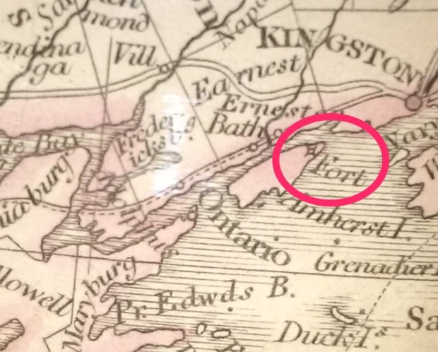
A fort marked on an old map of Amherst Island.
There, marked on the map was a fort, something I had never heard about. So, wanting to look for any remnants of this marked fort, I packed the car with my camera, my painting, and boarded the ferry in Millhaven, mere minutes from my childhood home.

The serene island on Lake Ontario. (Google Maps)
Arriving on the island, I was struck by how serene and peaceful it was, quietly stuck in another era, with its old homes, barns and stone ruins from the past spotting the landscape. After delivering the painting and enjoying a few cups of coffee and a chat with my new “islander” friends, I headed in the direction of where I thought the old fort ruins may be located. Travelling along the south shore of the island, I stopped to inspect a large stone off the shore, a granite boulder that looked out of place among the predominant sedimentary limestone that makes up most of the bedrock on the island.
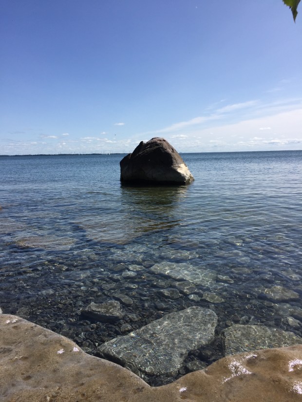
A large boulder amidst the limestone.
Cursing the fact I didn’t bring my swimsuit, I got as close to the boulder as I could, then turned around and noticed a weird stone grotto built into the cliff of the shore. In the dirt next to it was a bizarre tooth.
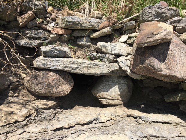
An oddly manmade looking stone grotto on the shoreline of the island.

Bizarre looking tooth found buried in the dirt near the grotto.
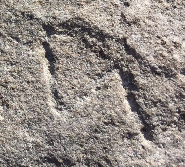
Curious, I now walked along the shoreline looking for other oddities and came across another large granite stone, this time on the shore and propped up with wedges underneath, to make it a standing stone, or “dolmen”.


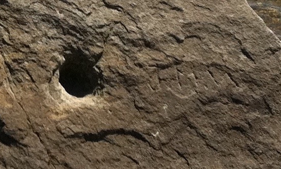
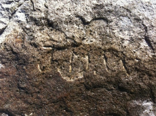
Carrying on further I came across a very large stone with two odd holes in it, and what looked to be an inscription on it.
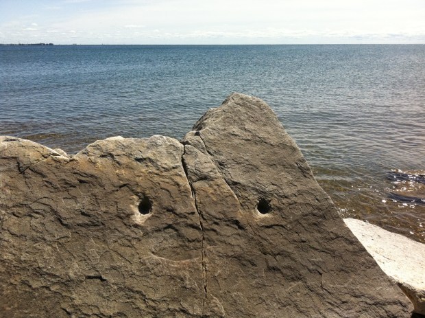
Large rock with two holes and odd inscription (right)
THE INSCRIPTION
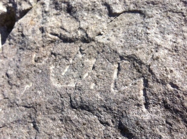
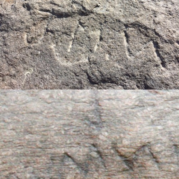
I’m unsure as to why two holes were in the rock, but I was even more unsure as to why there would be an inscription carved into the stone. Was it someone’s initials scribed into the rock’s surface by some early graffiti artist on the island? That was my first thought until I noticed the last figure was not a letter, but a symbol. What looked to be “JMW” seemed to more like a line of symbols than letters, and so I took a closer look.
I took photos of the rock and inscription and carried onwards to where the fort should have been, but found no trace of this old structure supposedly built by islanders who were armed and ready to engage any attackers from the United States to the south, coming across the lake during the Upper Canada Rebellions of 1837. The fort was apparently later abandoned, and fell away into history, its remains and location unknown. I returned back to the mainland with more questions than answers, as this island seems to have some odd ruins, interesting geological features and a beauty that needs to be re-visited.
ANALYSIS
The inscription look old and weathered, not a recent carving into the rock. The holes seem to be newer, but the symbols look much older. This of course would require a professional examination.
Studying the stone’s inscription further, I believe an explanation could be one of the following:
- Early settler or more recent graffiti carving of initials “JMW” but the carver did not have time to finish his letter ‘W’ with a final arm of the letter missing.
- Indigenous inscription
- Possible ancient visitor inscription
EXPLANATION 1: Modern/Early settler inscription
The most likely explanation is that the rock was scribed by some local resident bored at the water’s edge one day, who attempted to carve his initials into the rock but never had time to finish the last letter. Perhaps he was daydreaming and just started making holes in the rock as well. The island was once inhabited by out-of-work Rideau Canal Stone Masons of Irish and Scottish descent, so that could be likely. But why there? Why in such a remote and secluded spot? And why would the carver not finish their initials? After going to so much trouble, would you not want to finish the last letter of your initials before leaving, or at least come back later to finish the final arm of the letter W? The “M” inscribed, may not even be an M, but rather two separate symbols since they don’t seem to connect…but who knows until it is studied further.
EXPLANATION 2: Indigenous Carving
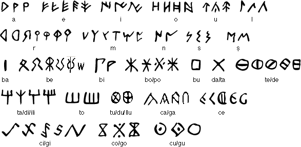
Amherst Island was once inhabited by the Iroquois and other natives to the area, so perhaps this rock was marked by a group who settled nearby. The markings seem to coincide with the markings left on a stone in Massachusetts called the Bourne Stone, with almost identical “J, M” , and the squiggle. Is there some connection to the Amherst Island stone and the Bourne Stone despite their separation by hundreds of kilometres? From my preliminary research, the local indigenous people did not carve stones, with the only evidence of ancient petroglyphs being near Peterborough. Were they made by the same tribes? Perhaps someone knows.
EXPLANATION 3: Ancient explorers
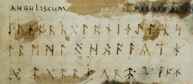
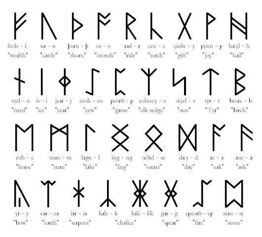
What first struck me about the last two figures of the inscription were their similarity to ancient rune scripts, the Norse runes and the ancient Futhark used by Ango-Saxon tribes.
Upon closer comparison, the inscription symbols also resemble Iberian Script, a script used in the southern parts of France and Spain during the early BC years. The symbols seem almost identical. Were ancient explorers from Europe on the Great Lakes leaving their mark on Lake Ontario? With the discovery of a Norse spearhead in 1929 across the lake from Amherst Island, it does seem plausible that perhaps Norse visitors made it to Lake Ontario and left a mark when they were here a 1000 years ago.
Again, I defer to the professionals to study the Amherst Stone in greater detail, but until that happens, the rock and its inscription will continue to weather the years on the shores of Amherst Island in quiet hiding.
Andrew King, September 2017
SOURCES
https://en.wikipedia.org/wiki/Amherst_Island#cite_note-4
https://en.wikipedia.org/wiki/Henri_de_Tonti
https://en.wikipedia.org/wiki/Elder_Futhark
http://www.ancientscripts.com/futhark.html
