Month: November 2016

Baffin Island Mystery: The unusual 700yr old carving of a robed figure with cross

carved-figure-baffin

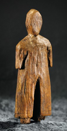
The robed carving dated to the 13th century with an etched cross found on Baffin Island (photo: historymuseum.ca)

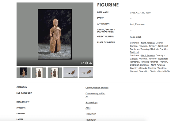
In storage at the Museum of History just across the Ottawa River from the Nation’s Capital lies an intriguing artifact labeled “KeDq-7:325”. If you type that number in the museum’s website search engine you reveal a fascinating entry about a mysterious 14th century wooden carving found on Baffin Island of a person in a tunic with a cross on their chest.

Further research reveals that The Canadian Journal of Archaeology Number 2 published in 1978 describes the recovery of a 6cm wooden figure from Baffin Island in the summer of 1977. While the rest of us were lining up to see Star Wars that summer, Deborah Sabo was at the settlement of Lake Harbour uncovering the remains of a Thule Culture village that contained 21 stone structures referred to as the “Okivilialuk Site”, a village  dated to be from the 13th century. Upon investigation of one of the stone structures, a wooden carving was recovered which depicts a figure clad in a strangely European looking tunic with a cross on the front, leading researchers to believe Europeans were interacting with the Thule people at that time.

With the only confirmed Norse settlement in North America located at L’Anse Aux Meadows in Newfoundland dated to 1000AD, this would mean there were European visitors to Canada roaming about in the 500 years between the Norse arrival at L’Anse Aux Meadows and European explorer John Cabot in the 15th century.

fullsizerender

The tunic clad figure was found near Lake Harbour (marked in red) on Baffin Island. (Google Maps)

The wooden figure depicts a person in some kind of tunic with a bordered edge and a split in the middle as well as an etched cross symbol on the chest. Researchers of the time believed it to be a depiction of a Greenland Viking with the tunic resembling the yoked hoods worn in the 11th to 13th centuries. With the Norse sagas mentioning a visit to a place called “Helluland”, this could refer to Baffin Island with the carving done by the native people on the island depicting this Norse visit as described in the sagas. A Norse robe with a split in the centre and cross as depicted has yet to be found in my research.

The Museum of History now contains the carving within its collection and describes it as being carved between 1250-1300AD and is of a Norse visitor to Baffin Island, which is intriguing, since the only confirmed evidence of pre-Columbian contact in North America has been through the artifacts recovered in Newfoundland. A representative from the museum tentatively stated that the figure is thought to be made from White Pine, a species of tree not found in the Arctic, or anywhere near Baffin Island for that matter.

The wood used to make the carving, if proved to be actually White Pine, Pinus Strobus,  is a type of wood that is only found in a select area of the continent. This means the wood for the carving made its way to Baffin Island via trading, or it was a piece of driftwood or even the visitors depicted in the carving brought it themselves. (map of White Pine distribution below)

pinus_strobus_range_map_1

Distribution of White Pine, the wood purportedly used for the figure carving. The areas of White pine are no where near Baffin Island in the arctic which means the wood used for the carving made its way there through other channels. (image: Wikipedia)

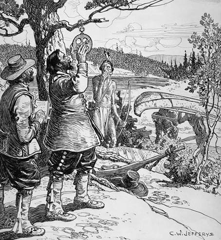
Speculation can also lead to another depiction in the carving, as it resembles closely the  Knights Templar, whose tunics of the 13th and 14th century do have a split in the centre and have a cross on the chest like that of the figurine.

An enduring legend states that the Knights Templar joined Henry I Sinclair, Earl of Orkney after the knights were condemned and exiled from Europe by the Pope and King Philip IV in 1307. Sinclair gave the exiled knights refuge and with his new friends the Templars, Henry Sinclair supposedly sailed with the vast religious relics and treasures of the Templars to North America in the 1300’s. The alleged trans-Atlantic journey had them exploring Greenland and the coastal regions of Canada where they established settlements and lived out their days among the natives. This theory is highly contested, and currently there has yet to be found any proof of this 14th century Templar voyage, although a Templar coin was recently recovered on Oak Island in Nova Scotia.

screen-shot-2016-11-28-at-9-20-43-pm

The official museum information regarding the recovered figure from Baffin Island (from historymuseum.ca)

Whether the little wooden carving is of a robed Christian Viking, a European monk, a Templar knight, or just a Thule native in an odd coat, one thing is for sure, the people residing on Baffin Island in the 1300s carved a representation of a visitor in a tunic with a cross on their chest at a time in history when such characters were not supposed to exist in North America.

It has been confirmed with the Museum of History that this intriguing object known as KeDq-7: 325 will ultimately be displayed with its provenance when the museum re-opens its Canada Hall in 2017. This grand hall will depict our country’s ever evolving history, featuring items that can be readily explained, and perhaps those that remain unexplained.

Andrew King, November 2016

SOURCES

http://www.historymuseum.ca/collections/artifact/482525/?q=keDq-7%3A325&page_num=1&item_num=0&media_irn=379962

https://www.jstor.org/stable/23006521?seq=1#fndtn-page_scan_tab_contents

https://en.wikipedia.org/wiki/Henry_I_Sinclair,_Earl_of_Orkney


THE NUCLEAR REACTOR THAT WAS ONCE AT TUNNEY’S PASTURE

SLOWPOKE REACTOR

Sketch from The Canadian Association Of Mechanical Engineers of what the Tunney’s Pasture nuclear reactor looked like.

(This information comes from an earlier OttawaRewind post written in 2014. You can read the full article here.)

Recently the National Capital Commission revealed plans to make Tunney’s Pasture the site of the new Civic Hospital campus. The current Tunney’s federal government complex is a mix of mid-century and 1970s office buildings and towers, a boring collection of grey concrete. Something that is of more excitement however, is the fact that the area was once home to a nuclear reactor.

AECLbuildings1965

Atomic Energy of Canada Limited Buildings located on the Tunney’s Pature Complex that housed the SLOWPOKE nuclear reactor 1971-84.

The year was 1970 and the Atomic Energy Canada Limited, or AECL, was placing a SLOWPOKE-2 class nuclear reactor at Tunney’s Pasture. According to The Canadian Society For Mechanical Engineers documents, this nuclear reactor was installed in Tunney’s Pasture at 20 Goldenrod Avenue. It was constructed as a commercial testing reactor to determine its feasibility. This nuclear reactor was in full operation after it reached critical mass in 1971 until 1984 when it was then moved to another test site located in Kanata, later decommissioned in 1992.

tunneysoverview

Aerial image showing the proximity of the Remic Bunker to the Tunney’s Pasture Nuclear Reactor site.

The reactor, nicknamed SLOWPOKE, (an acronym for Safe LOW-POwer Kritical Experiment) which used 93% enriched uranium. The reactor core sits in a pool of regular light-water, 2.5 m diameter by 18 feet deep, which provided cooling. The reactor built at Tunney’s Pasture achieved “Critical Mass” or the point at which a nuclear reaction is self-sustaining on May 1 1971 and continued operating until 1984.

The oddly shaped circular concrete bunker that remains on the shore of the Ottawa River directly opposite the old nuclear reactor site was built at the same time as the reactor in 1969-70. It was built to facilitate the increased “cooling” needs of Tunney’s Pasture, one of them you could speculate being the addition of a small nuclear reactor.

IMG_2348

The mysterious concrete bunker at Remic Rapids has perplexed many a passerby.

The pumping station bunker and pipeline were finished in 1970 and the reactor began operating a year later. Whether or not the bunker pipeline bringing cooling water to Tunney’s Pasture was directly related to the addition of a nuclear reactor remains speculation but it is interesting to note the proximity and similar timeline of both projects.

You can follow the intake cooling water pipe by tracing a path that follows a series of manhole covers that lead from the river to the Tunney’s Pasture site.

coling trench

The buildings where the nuclear reactor once existed have since been demolished, and it is currently an empty gravel parking lot, and possibly soon to be part of the new Civic Hospital plans recently announced.


Andrew King, November 2016. 


SOURCES

geomap Ottawa

http://en.wikipedia.org/wiki/SLOWPOKE_reactor

http://www.newspapers.com/newspage/44420893/

Click to access CSME-Slater.pdf

http://media.cns-snc.ca/history/canadian_nuclear_history.html

Google Maps

Bing Maps

The Mysterious Spectra-1 Hovercraft Made In Ottawa

speccolr

The Spectra-1 made in Ottawa in a photo from the 1971 sales brochure of it on the Ottawa River. Note the Champlain Bridge in the background (from decastris.com)

The year was 1970 and on River Road south of Ottawa a company was building hovercraft vehicles. Dubbed the “Spectra-1”,  this unique vehicle was straight out of a James Bond film of the same era. The product of Modern Hover Vehicles, a company that existed on paper at the address of 1078 Queensdale Ave.in Blossom Park, but that address has apparently never existed.

spectra_i_1

Sales brochure of the Spectra-1 (from decastris.com)

Introduced in 1970 as the “Spectra-1”  with an air cooled 18.5 HP Single Cylinder hover engine and similar propulsion engine, this orange fiberglass bodied hovercraft would travel at speeds of up to to 45 MPH on land and on water up to 40 MPH, yet over ice the Spectra would reach a blazing 60 MPH.

sectra_i_2

More info on the Spectra-1 made in Ottawa.Note Champlain Bridge in photos. (from decastris.com)

The Modern Hover Vehicle sales brochure touted the Spectra-1 as the “in thing for the in people” and photos show the hovercraft traveling over the rapids of the Ottawa River at the Champlain Bridge area.

spectra_march_24_2016_pp21055

A provocative image from the Spectra-1 sales brochure with a frozen Ottawa River in the background (from davidsleds.mysite.com)

This Ottawa company building these craft on River Road then improved on the Spectra-1 by introducing the Spectra-2 which was developed in 1973. The Spectra-2 used bigger 2 stroke engines and incorporated an enclosed plexiglass cockpit windshield for the driver.

The Spectra-2 was, according to their sales brochure, “The most advanced light hovercraft in the world” and was for applications in the geological, armed forces, police and rescue fields of use.

spectra2a

The Spectra-2 with enclosed canopy. (from decastris.com)

The company, Modern Hover Vehicles, had an address of 1078 Queensdale Ave. but that address does not seem to exist according to Google Maps. A fellow on Twitter said he had acquired a Spectra-1 in a trade and is in the process of restoring it, but that is the only one I have ever seen.

cdsphgnxiaai_5u

A Spectra-1 in the United States awaiting restoration. (photo submitted by Matt Norman via Twitter)

It is unclear what ever happened to the mysterious Ottawa born Spectra Hovercraft, the company that made them, or if any others are still in existence.

Andrew King, November 2016

SOURCES

http://www.decastris.com/hcc/builders/mhv/spectra1.htm

davidsleds.mysite.com/


Ottawa’s Forgotten Mega-Structure


img_4547

The Glebe neighbourhood of Ottawa is home to many things, including Lansdowne Park, a place that has been host to many large-scale events throughout history. Yet the largest event is one that seems to be lost in time, the great Marian Congress of 1947.  It involved the construction of one of the world’s largest outdoor churches on the grounds of Lansdowne park but nothing remains to remind us of this grand mega-structure.

img_4550

Like something from Metropolis, the massive Lansdowne structure hosted nightly religious ceremonies. 

With a capacity to seat 75,000 visitors, this massive compound was constructed in 1947 and rivalled the megalithic architecture of German architect Albert Speer, creating a 500 foot long structure on the banks of the Rideau Canal.

screen-shot-2016-11-16-at-8-44-10-pm

The massive monument built on the edge of the Rideau canal at Lansdowne. (Ottawa Citizen)

Part of the “Marian Congress” the huge structure was the centre of Ottawa’s greatest pilgrimage that brought over a quarter million people to the city, making it the only event in Ottawa’s history to bring that many people from all over the globe. However, this epic spectacle is largely forgotten, except for what is recorded on a 70 year old film clip that showcases this gargantuan event in the Nation’s Capital.

img_4545

A still from the 1947 film that showcases the huge crowds of the Marian Congress in Ottawa at the Lansdowne super-structure. (YouTube)

With its over 75,000 seats and 500 foot stage, the Marian Congress was not only one of the world’s largest outdoor churches, it also hosted one of North America’s largest fireworks displays and a singing performance by the Dionne Quintuplets. Between June 18 and June 22 tens of thousands of people crowded Ottawa streets in hopes of attending Catholic mass at this Lansdowne super-structure.

screen-shot-2016-11-16-at-8-51-22-pm

Photo from the Ottawa Citizen, June 16th 1947 showing the magnitude of the structure in model form. (Ottawa Citizen)

The sanctuary was constructed by the Ottawa contractors Collet Freres Ltee. and was painted in the colours of the Blessed Virgin Mary which were white and blue. The giant white compound was a meeting place for the crowds of thousands of Catholic pilgrims that had come to Ottawa to pay tribute to their faith and pray for everlasting world peace.

img_4546

The main stage area of the mega-church at Lansdowne. (YouTube)

The event concluded with a procession of illuminated boats on the canal and a massive fireworks display. The structure was eventually torn down, the seats removed and within a short time the whole thing disappeared without a trace. Nothing remains today to remind us of this mega-structure that once stood in the heart of the city.

img_4548

Andrew King, November 2016

SOURCES

The Ottawa Citizen, June 16 1947. https://news.google.ca/newspapers?nid=QBJtjoHflPwC&dat=19470616&printsec=frontpage&hl=en

YouTube: https://youtu.be/-lt_hyYG0q8


An Ancient Path Along The Ottawa River

For millennia the Ottawa River has tumbled along into the St. Lawrence River, carrying vessels containing trade items such as ancient copper from Lake Superior, New World explorers, missionaries, furs, and thousands of logs. It has been an important conduit of trade used by the indigenous population to carry goods and themselves back and forth for centuries, portaging along paths they made to circumvent around its many waterfalls and rapids.

cnfkjfcwyaac-vo

A map from the book “The Upper Ottawa Valley” by Clyde Kennedy shows the ancient native copper trade route using the Ottawa River.

It was these same paths that the early explorers such as Champlain and the fur trading voyageurs would later follow. One such ancient path exists just steps from downtown Ottawa on a path called the “Voyageurs Pathway” on NCC property.

screen-shot-2016-11-06-at-10-08-20-am

The original path as it appears on the north side of the Ottawa River.

This path still exists much as it did hundreds of years ago, cut through the vegetation along the north shore of the Ottawa River skirting around the tumultuous Chaudiere Falls and the the rough rapids just upstream from it. It sits quietly concealed, sadly vandalized with graffiti with its former commemorative plaques now missing. It is unfortunate that it seems neglected despite its historical importance in Canadian history.

On a more positive note, the ancient path is in an area that has surprisingly not been touched by development and retaining many of its original characteristics. Situated so close to the downtown core, you’d think the whole area would have been turned into federal office buildings or some sprawling residential development. However to the contrary, it sits as it has for thousands of years, the many unique features, both natural and manmade, waiting to be explored and enjoyed like the people before us once did so many years ago.

THE MISSION

I decided to retrace the same steps of the people that once used the path centuries ago, following in the footsteps of people like Samuel de Champlain, the fur trading Voyageurs, indigenous people and the Jesuit missionaries of the the 1600’s. They used this exact same path to go around the falls and rapids, and I have to say it was remarkable to experience the same adventures they encountered.

THE TRAIL

The trail begins at the NCC owned Brebeuf Park off the main road near the entrance to Gatineau Park. Here there is a statue of Father Jean de Brebeuf, a Jesuit missionary who travelled up the Ottawa River in 1634 to meet the Huron people where he later set up his missionary work before being tortured and killed by the Iroquois. An impressive bronze statue erected in 1930 to commemorate the journey of Brebeuf almost 400 years ago has had its descriptive plaque I’m guessing ripped off by scrap metal thieves, but no information is now present to tell you about the statue.

screen-shot-2016-11-06-at-5-56-20-pm

The statue of Brebeuf as it appeared in 2015 with its bronze plaque in place. (Google Streetview)

img_1153

The Brebeuf statue as it currently appears with its plaque now missing.

img_1154

Missing plaque.

Travelling east on the manicured path there is a rough cut trail that follows the shoreline of the river, and you can see rough cut stone steps used by former portaging travellers centuries before. It was quite amazing to literally take the same steps as Champlain and the other adventurers who stepped off their canoes here.

img_1161

champlain-jefferys-lac

Champlain portaging on the Ottawa River c.1613 (CW Jefferys, Library and Archives Canada)

Inspiring views of the river I have never experienced before met my eye in addition to unusual rock formations, although I was saddened to come across yet another missing plaque that would have explained the path’s historical significance.

img_1165

Another missing plaque that would have described the historical importance of the path.

The ancient rocks where native people and European explorers once docked their craft to portage the falls now lie covered in spray painted graffiti and trash. Not a fitting tribute for such an important and rare original piece of history.

img_1163

A rock shelf where people portaged from for centuries now covered in graffiti.

Moving on, I imagined Samuel deChamplain in 1613 with his Algonquin guides in their birch bark canoes, lifting them up here to traverse the same trail I was on and came across an unusual rock formation like a giant stone amphitheatre that I’m sure has some archeological relics in it, but thought it best left to the professionals to study someday.

img_1170

This large “bowl” depression off the path was probably used for some ancient camp.

There were more unusual formations, which were a combination of man made and natural features, some of which I’m sure are very old and pre-date any European contact. Again, I am sure someday the proper individuals will study these further if they haven’t already.

img_1171

An unusually large boulder with rocks piled on the south side of it.

Next I came across a huge bay of water marked “Squaw Bay” on the map. Again, unusual rock formations, and traces of some kind of man made structures abound and I would later learn from a study done in 1901 by TW Edwin Sowter, that this was indeed an ancient campground:

“To all appearance, it seems as if this spot had been a landing place at the foot of an old Indian carrying-path, which led up to the head of that break in the canoe route of the Ottawa River caused by the little Chaudière Rapids…the western shore is strewn more or less, throughout its entire length, with fragments of worked flint, just as we meet with them at similar places… There is no doubt that, in prehistoric times, there were periods of tribal inactivity, during which an Indian community may have lived in such peace and comparative security, at Squaw Bay, as to have led even its younger members to indulge in the contemplation of making old bones ; but the situation of the dwelling sites of these palaeolithic people.”  -Sowter, 1901, The Ottawa Naturalist, Vol. XV, No.6: 141-151

Sowter seems correct in saying this place was a former native encampment because there are countless ledges and areas of steep stone that makes a natural fortress with its high cliffs and moat like waters. Again, I defer to the professional archeologists and academics to study this intriguing area further.

img_1172

The large bay and cliffs of Squaw Bay where an ancient camp once was.

After making my way around Squaw Bay, I headed to where the now barricaded Prince Of Wales railway bridge hits the Gatineau shore, and there, off the path lies a a curious stone wall that seems to pre-date the railway which was built there in 1880. The railway embankment here cuts into this old stone wall which makes it look like it was built earlier. The wall is approximately 80 feet in length, 3 feet high, and 2.5feet wide. It is constructed in the ancient drystone masonry technique, but why it is lying tangled in wild grape vines surrounded by swampland is beyond me.

img_1190

An old drystone wall.

Perhaps it was an old farming wall used to contain livestock from the Philomen Wright days of Hull in the early 1800’s, but the land is rocky and swampy making it inappropriate for farming or grazing.  Without further study of this fascinating old wall overlooking the river, we may never know its purpose.

img_1185

img_1182

The old stone wall tangled in wild grape vines overlooking the Ottawa River, purpose unknown.

At this point I turned back, retracing the steps of ancient travellers, famous explorers, adventurers, and warriors who used this very same path,  virtually unaltered from its original state. (minus the vandals and graffiti). It seems a shame that such an important trail has been neglected, with informative plaques lost to the prying hands of scrap metal thieves. With Canada’s upcoming 150th anniversary in 2017 perhaps the NCC as caretakers of this important piece of Canadian history will consider replacing the plaques and maintaining this concealed pathway through time, giving it the respect it has duly earned over the years.

Andrew King, November 2016

SOURCES

Google Maps

https://en.wikipedia.org/wiki/Jean_de_Brébeuf

Samuel de Champlain 1604-1616

http://www.historymuseum.ca/cmc/exhibitions/archeo/sowter/1901/sowter1901e.shtml

The Canadian Tire Triangle

The Bermuda Triangle is a legendary triangular region of the Atlantic Ocean where hundreds of ships, planes and people have disappeared through mysterious circumstances. A far less studied triangle exists in our northern hemisphere, a triangle with its own special powers. Like a glowing, hot branding iron that has been burned into our inner retinas after leaving the womb, it is the image of the Canadian Tire triangle.

now

The inverted red triangle with a green maple leaf logo on top is just about as Canadian as a ketchup chip dipped in maple syrup, yet many don’t realize the story behind this simple Canadian icon.

When the two brothers Alfred and John Billes opened the first Canadian Tire store in 1926, the company’s logo was a rather bizarre cartoonish rubber tire wearing elven booties dragging behind a coin character wearing the same medieval footwear. Under the slogan “The Longest Run for Your Money”, this logo of the Canadian Tire Corporation would carry on until the 1940’s when a red wax seal and ribbon logo appeared in their advertising and catalogues. This common “seal of approval” motif would continue until something happened that would live on into our subconscious: a red triangle.

canadian-tire-timeline

THE RED TRIANGLE

Appearing around 1950, the inverted red triangle with a green maple leaf would appear and remain a symbol for the Canadian Tire corporation for 66 years, and will probably continue for many more. The original red triangle was outlined in green and included the word “corporation” shortened to “CORP’N”. In 1958 our famous  collected currency known as “Canadian Tire Money” appeared  at a Canadian Tire gas bar at Yonge and Church St. in Toronto. Yet it would not be the new red triangle symbol that would be the logo on the bills, but rather the original elven socked “running tire and coin” image that started with the company 32 years earlier.

c87485d5583f234b695d081b0e8e32f9

When first introduced in 1958, the CT money used a slightly updated “tire & coin” logo. The red triangle and seal are also displayed.

The now famous “Scarfed Scotsman”, Sandy McTire, who symbolized the thrifty shopper, showed up on CTC money in 1961 and continues to appear on the bills today. At one time, Canadian Tire money was manufactured at the BA BankNote company here in Ottawa, right alongside our actual Canadian currency bills, using the same inks and paper, resulting in a durable currency bill that many still have and use to this day.

THE CHALICE

The inverted triangle symbol used by CTC is actually an ancient symbol with a very unique meaning behind it. It has been the representation of the earth and water. The downward pointing triangle is also an ancient symbol of femininity, being a representation of the female womb, or a chalice…”the giver of life”. One of the four alchemical elements, water symbolizes intuition, the unconscious mind, and the enclosing, generating forces of the womb. It also represents the force of Earth or gravity, or Mother Earth. In developing countries, the inverted Red Triangle is the symbol for family planning health and contraception services, again part of the “womb” symbology mentioned earlier.

This inverted red triangle of Canadian Tire was streamlined in the late 1960’s with the company name placed inside the triangle. This would be the everlasting symbol for the company that would be emblazoned into the psyche of every Canadian.

But why a red inverted triangle? According to the Canadian Tire website, the triangle holds a “98% instant recognition among Canadians. That’s the power of the Canadian Tire triangle.” In 2012 Canadian Tire finally revealed the secret behind the instantly recognizable triangle; in a single Twitter statement they said it was chosen by the founder, Mr. Gilles:

“Chosen because our founder needed one for the front of an oil can. A triangle was a simple, easy to recognize symbol.” 

screen-shot-2016-11-01-at-11-49-38-pm

The secret behind the Canadian Tire logo revealed on Twitter in 2012.

Perhaps not as mysterious as the Bermuda Triangle, but our Canadian Triangle possesses its own, shall we say, “magnetic properties”.

Andrew King, October 2016

SOURCES

http://www.autofocus.ca/news-events/auto-retro/a-brief-history-of-canadian-tire

http://www.steelart.com/about.html

https://en.wikipedia.org/wiki/Canadian_Tire

http://www.canadiantire.ca/en.html

http://symboldictionary.net/?tag=triangle

http://www.thefullwiki.org/Red_Triangle,_Family_Planning