Month: September 2023

THE WORLD’S FIRST NUCLEAR REACTOR WAS IN OTTAWA?

With the recent popularity of the the film “Oppenheimer”, I was curious as to where the world’s first nuclear reactor would have been located. It’s amazing the information you can find by doing a simple Google search. It seems that with proper funding, more time and purer materials, the first man-made nuclear chain reaction would have taken place in Ottawa. A scientist working at he National Research Council in 1940 by the name of George C. Laurence made the first experimental nuclear reactor in 1940.

Dr. George Laurence, Canada’s engineer of the first nuclear reactor designer.

A year later, the Chicago Pile-1 (CP-1) became the world’s first successful artificial nuclear reactor. On December 2nd, 1942, the first human-made self-sustaining nuclear chain reaction was initiated in Chicago with the CP-1 reactor.

A year earlier, another reactor was initiated in Ottawa, but lacked the proper materials to be completely successful. Dr. Laurence joined the staff of the National Research Council of Canada in 1930 and became active in improving the measurement of radiation dosage in the treatment of cancer and in promoting safety from radiation exposure, but also became instrumental in creating nuclear energy.

With the world superpowers entrenched in a World War, the Commonwealth country of Canada seemed like an unlikely candidate for creating nuclear power, but like most technological advancements, Canada persevered and was a pioneer in the field.

Research in the National Research Council of Canada during WW2 was focused on wartime efforts to advance allied technology against the Axis powers, and one such avenue of research was that of nuclear energy.

Ottawa’s first National Research Council building on Sussex Drive.

Dr. Laurence in Ottawa in 1940 surmised in his spare time that a very large number of fissions produced in a reaction would release a large amount of energy. There was evidence to show that a large increase in the rate of producing fissions would be easier to accomplish if the neutrons were moving slowly. They would move more slowly if they encountered large numbers of very light atoms such as hydrogen atoms; therefore, it might be advantageous to associate with the uranium a suitable quantity of material containing hydrogen, such as water. Heavy Water.

By this time however, the nuclear scientists in England and the United States had stopped publishing the results of their research, and continued their work in secrecy. With heavy water extremely scarce and hard to produce, Laurence decided to try and use just basic carbon instead of heavy water in his nuclear reactions, as it was cheaper and easier to produce.

So, in Ottawa, between 1940-42, Laurence decide to create his own “Nuclear Reactor” using carbon powder instead of heavy water.

World’s first nuclear reactor went operational in Ottawa 1941.

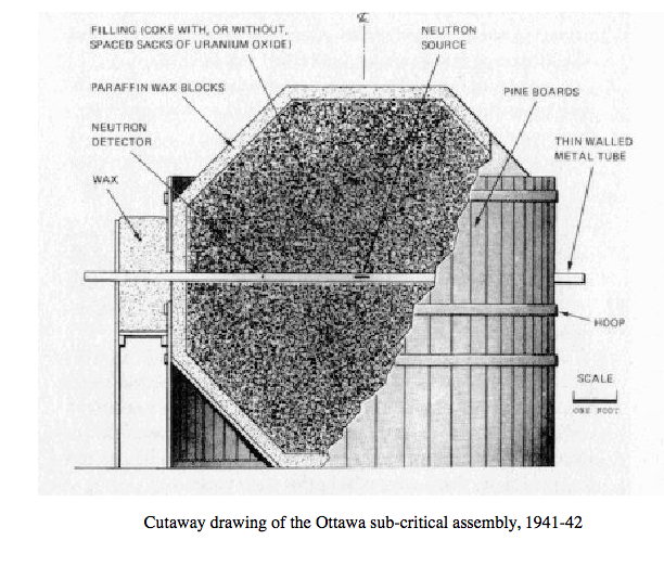
Here are the actual experiment notes from Dr. Laurence on what was likely the world’s first nuclear reactor experiment that occurred in Ottawa:

“In our experiments in Ottawa to test this, the source of neutrons was beryllium mixed with a radium compound in a metal tube about 2.5 centimetres long. Alpha particles, emitted spontaneously from the radium, bombarded atoms of beryllium and released neutrons from them. The carbon was in the form of ten tonnes of calcined petroleum coke, a very fine black dust that easily spread over floors, furniture and ourselves. The uranium was 450 kilograms of black oxide, which was borrowed from Eldorado Gold Mines Limited. It was in small paper sacks distributed amongst larger paper sacks of the petroleum coke.

The sacks of uranium and coke were held in a wooden bin, so that they occupied a space that was roughly spherical, 2.7 m in diameter. The wooden bin was lined with paraffin wax about five centimetres thick to reduce the escape of neutrons. The arrangement is shown above, as a sectional view through the bin and its contents.

A thin wall metal tube supported the neutron source at the centre of the bin, and provided a passage for insertion of a neutron detector which could be placed at different distances from the source. In the first tests the detector was a silver coin, but in most of the experiments it was a layer of dysprosium oxide on an aluminum disc.

The experimental routine was to expose the detector to the neutrons for a suitable length of time, then remove it quickly from the assembly and place it in front of a Geiger counter to measure the radioactivity produced in it by the neutrons. The Geiger counter tubes and the associated electrical instruments were homemade because there was very little money to spend on equipment.”

By 1942, Laurence realized that the nuclear energy released was too small because there was too much loss of neutrons by capture in impurities in the coke and uranium oxide and in the small quantities of paper and brass that were present. These little impurities could lead to failure, and the American and British research teams took over the experiments using more refined materials.

It was in 1942 after these initial Ottawa nuclear experiments that is was decided that a special unit of nuclear research would be set up in Montreal.

On this site, now occupied by an apartment building, the Montreal Nuclear Laboratory was established. (Google Streetview)

On September 2, 1942 Canada received scientists from England, and was provided laboratory facilities and supplies and administer the project in Montréal as a division of the NRC.

The first of the staff from England arrived about the end of the year 1942 and set up shop at 3470 Simpson Street belonging to McGill University.   Three months later, they moved into a 200 square metre area in the large, new building of the University of Montréal, and more scientists and technicians arrived from England.  

The Project became part of the Manhattan Project and with great enthusiasm, a Canadian group of scientists were brought together with a single purpose…to create nuclear energy.

Building reactors in downtown Montreal was out of the question; so the Canadians selected a site at Chalk River, Ontario, on the south bank of the Ottawa River some 110 miles (180 km) northwest of Ottawa.

The nuclear reactor building at Chalk River, ON
Cutaway drawing of how the ZEEP reactor operated.

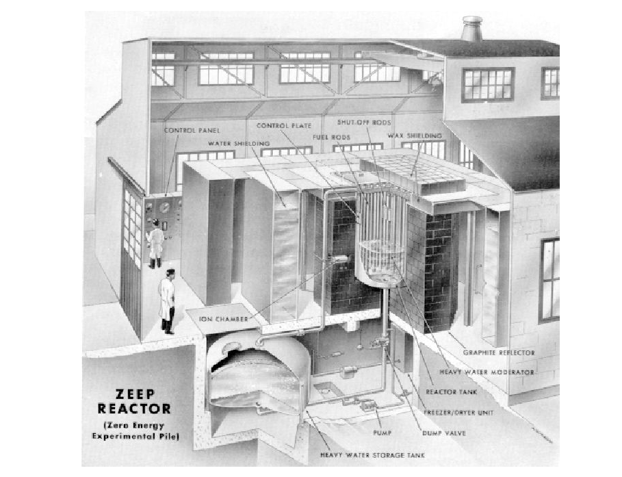
This is where Canada’s first operational nuclear reactor was born, called “ZEEP”. The Chalk River Laboratories opened in 1944, and the Montreal Laboratory was closed in July 1946 when the Chalk River reactor went critical on September 5th, 1945, becoming the first operating nuclear reactor outside the United States.

Andrew King, September 26th, 2023

SOURCES

https://en.wikipedia.org/wiki/Montreal_Laboratory

https://www.cns-snc.ca/media/history/early_years/earlyyears.html

THE SEARCH FOR A VICTORIAN ERA WASHROOM SEALED BENEATH SPARKS ST

One of the most enduring legends in Ottawa that always sticks in the back of my head like a Kerr’s Halloween caramel on a molar, is the urban folktale that beneath Sparks Street there is a concealed Victorian era public washroom. Sealed for a century, in perfect preservation, awaiting its triumphant return from beneath the asphalt like the Ark of Covenant. With a busy summer schedule behind me, I thought I should probably attempt to put this curious history mystery to rest. Well, guess what?…it’s probably true.

BACKSTORY

Public toilets have been a part of human sanitation since ancient Rome. Long stone benches with holes accommodating multiple and simultaneous users with no privacy, these first public restrooms were thought of as a social event.

An ancient Roman public washroom in Ostia Antica

Fast forward a few centuries ahead and underground public toilets were introduced in the United Kingdom during the Victorian era. These facilities were accessible from the city street by stairs, and lit by glass brick on the pavement above. Local health boards often built underground public toilets to a high standard, a classy reprieve for “doing your business” whilst enjoying the city.

A Victorian era public washroom accessed from the street to underground.
An underground public washroom entrance in Toronto circa 1890-1920s.

By 1919, more than one hundred cities had opened above-ground or underground “comfort stations”, and Ottawa was one of them.

LOCATION

Throughout my time writing these Ottawa Rewind posts I have often been e-mailed about pursuing certain subjects, and I have had some great conversations at numerous pubs and restaurants with individuals suggesting topics I should maybe write about, and the “hidden Sparks St washroom” has been always favourite topic of mine.

In the search for Ottawa’s sealed Victorian lavatory, I began my quest for answers by first checking the GeoOttawa historic mapping aerial photos of the Sparks St area. Nothing really came up except for some curious structures just around the north corner, on O’Connor St. (full circle: this is where I was told that I could not give out free t-shirts celebrating Canada150 in 2017)

A 1928 GeoOttawa image shows some likely washroom structures.

The next step was going through the Library and Archives Of Canada website archive search of photographs around Sparks St that may show these fabled public restrooms. It soon became apparent that the underground public washrooms of Britain were also popular in Canadian cities during the Victorian era, especially in Toronto which had many examples in photographs. These were usually structures on the street level with stairs that led down into the restroom facility.

Interior of an underground public washroom from the early 1900s.

Ottawa would likely be no different, and with Sparks Street being the “hub” of Ottawa at the time, it would make sense that we would have a similar setup. O’Connor Street makes the most sense as to the the location of said underground washrooms as it is the halfway point along Sparks, a perfect location to place a public restroom if people were meandering down Sparks St. from either direction in the early 1900s.

Focusing on the O’Connor angle, I narrowed the search at the Library and Archives to collect photos from the era of 1880-1915 and found some interesting images. Once such photo shows Sparks/Wellington/O’Connor in 1869 with two street level structures in the middle of the street.

An 1869 photograph showing what appears to be “Pissoirs” on On’Connor.

These could be what was called a public “Pissoir” a French word for an invention, common in Europe, that provided a urinal in public space with a street level structure. This is the etymology behind the word “piss” or “I’m going for a piss”. Crude nowadays, but actually based on actual historical terminology.

A French “Pissoir” street level washroom structure.
A Pissoir on a Victorian era Montreal city street.

So with what looks like a couple of “Pissoirs” on O’Connor just north of Sparks St., I began scouring the old newspapers looking for any articles mentioning public underground washrooms in that zone. Well, lo and behold, I struck the jackpot.

POTTY TALK

When Sparks Street transformed into a pedestrian mall in the 1960s, the once bustling spine of the city became a different place, and any history of its past was shrouded with a new progressive vision for the Nation’s Capital. Former historic buildings were transitioned into a “modern vision” for the Capital, and any Victorian underground washrooms would likely be sealed up and paved over.

In this 1938 photoof Sparks St and O’Connor Street, the entrance to the underground washrooms have been covered over.

However, it seems that idea came much earlier, as by 1938 there is no photographic evidence of any washroom structures being on O’connor, but what is mentioned via a newspaper, is the fact they did exist!

A 1967 Ottawa Citizen article mentioning the fabled Victorian underground washrooms.

In a 1967 Ottawa Citizen article, mention of a sealed underground washroom was made: “two long sealed public washrooms, just north of Sparks on O’Connor Street, will remain closed under their coatings of concrete and asphalt.” AHA! So the rumours are true!

Another Ottawa Citizen article mentioning the sealed underground washrooms.

Then, another article was found, this time from an earlier edition of the Ottawa Citizen, where it was mentioned: “A large public washroom of Roaring Twenties style awaits re-discovery below O’Connor Street”…That makes two mentions in the Ottawa Citizen!

CLOSING THE LID

With so many pieces of the puzzle coming together, I thought it best to return to GeoOttawa and see if there are any sewer or water mains that may show up on their mapping system that would indicate the presence of an old sealed underground washroom. Et Voila. The GeoOttawa sewer map shows a “capped” line on O’Connor which is likely the capped water lines to and from the Public Underground Victorian Era Washroom (PUVEW). Yes, I made that up.

This GeoOttawa image shows a capped sewer/water line where the underground toilet would have been.

With new evidence in hand, I once again scoured the Library and Archives photo library to see if there were any photos in that area that might indicate an entrance to an underground washroom facility.

Your view looking south down O’Connor in 1900s after exiting the underground washroom.

After a lengthy search, one photo from 1909 came up that showed a view of Sparks and O’Connor and upon zooming in….BINGO!

A built structure showing what appears to be the entrance to the fabled underground public washroom! There it was, in Black and White from 1909. The Holy Grail of Ottawa legend reveals itself in all its glory.

This image taken from a photograph at the corner of Sparks and O’Connor in 1909 clearly shows the entrance structure to the washroom below.

BREAKING THE SEAL?

Upon realization that there was indeed a public underground washroom on O’Connor Street off Sparks Street that existed sometime between 1869 and 1928, it begs the question: Is it still there?

The Washroom Entrance.
This image taken from a photograph at the corner of Sparks and O’Connor in 1909.
The same view at the same location, in 2023.

Using Google Maps to pinpoint what’s currently at that location, it seems there is a concrete sidewalk over the spot but that doesn’t mean we can’t use current technology to investigate further.

Beneath this sidewalk is the concealed Victorian public washroom.

If enough of us are interested in seeing if the sealed Victorian Washroom is still there, then perhaps we can Crowd Fund a Ground Penetrating Radar expedition to map out what lies beneath, or, simply ask the City Of Ottawa and the National Capital Commission and/or Government of Canada (they own north of Sparks Street area) to uncover what they undoubtedly know exists below.

If anyone else may haver photos or further proof the underground washroom existed/still exists, please contact me.

A 1912 Fire Insurance Plan map shows no underground washroom.

Until that time, the legend of the sealed Victorian Public Washroom seems to ring true, and until it can be confirmed with some jackhammers, the truth will be forever flushed below.

Andrew King, September 20th, 2023

SOURCES

Library and Archives Canada

GeoOttawa

Fire Insurance Maps: Carleton University: https://storymaps.arcgis.com/stories/4752d4c2e21e4c6b9601a18fbdd7991e

PRIMITIVE “MYSTERY” CANALS SUBMERGED UNDER THE OTTAWA RIVER

Unexplained engineers built primitive canals along the Ottawa River that are now underwater…

AN ANCIENT HIGHWAY

The Ottawa River has been a conduit for travel and trade for thousands of years, from ancient vessels carrying raw copper mined in Lake Superior to the massive lumber rafts of the late 19th century, it has been something of a super highway for centuries. Ancient clay pots have been found in Luskville caves, with forged copper weapons from 6,000 years ago found on Ottawa River islands that show a vast ancient trade network with distant regions that seem unbelievable. Exotic materials originating from as far away as the tip of Labrador and a 2,000 year old knife found near Ottawa was was made from a type of stone only found in Ohio, USA. The Ottawa River provides water access to a variety of areas through the Rideau river, the St. Lawrence, the Great Lakes and beyond. Likewise, visitors from any those places and beyond could have visited the Ottawa area.

A map showing the ancient copper trade conduit that was the Ottawa River. (From “The Upper Ottawa Valley” by Clyde Kennedy)

That’s what makes the discovery of a series of primitive canals that are now submerged beneath the waves of the Ottawa River so intriguing.

Prior to the current navigable Ottawa River system that opened in 1963, there were a series of rapids that made continual boat travel on the Ottawa River impossible. Portaging was necessary. When the Carillon Dam was completed east of Ottawa in 1963 it raised the water level by between 9-62 feet allowing ships to travel freely between Ottawa and Montreal. This flooded out the rapids of Long-Sault on the Ottawa River, but also any previous shorelines, including a series of what were called “primitive canals” whose builders remain a mystery.

EIGHT CANALS WITH HUGE BOULDERS MOVED

In his 1984 book “The Ottawa River Canal System” Normand Lafreniere writes about a series of primitive canals that were once on the original shoreline of the Ottawa River near what is now Hawkesbury, Ontario. A series of British military canals were built along the Ottawa River in the 1830s but these other canals pre-date those to some unknown period and builder.

Lafreniere notes that their construction is “extremely primitive, not to say archaic, for that period” and the builders of these canals used techniques that included moving boulders weighing in some cases nearly 1 ton. These massive stone boulders also contained unusual drill holes.

“They were in fact little more than trenches formed by the removal of some of the numerous large boulders found along the north bank of the Ottawa River in the vicinity of the Long Sault. These rocks must have been serious hazards to navigation as many of them were removed to allow the passage of canoes and other craft. Altogether eight “canals” formed in this way were observed…”

A drawing from Lafreniere’s book showing the locations of the primitive canals.

It remains unknown who constructed these canals, and they were all lost in time when the river water rose in 1963 completely submerging all evidence of them. Lafreniere remarks in his report that it is not likely they were built by the native indigenous travellers as they would not have had the drilling tools necessary to drill 10 inch holes into solid rock that were found on the 1 ton boulders. Another speculation made is that they were constructed by the various fur trader expeditions that used the Ottawa River as their lucrative trade freeway, but no known mention in any literature of both the French fur traders or Hudson’s Bay Company makes mention of these canals.

A Google aerial image shows the vague outline of some of these now submerged mystery canals.

So who would have made the labour intensive effort to construct 8 canal trenches along the Ottawa River? A historian by the name of Cyrus Thomas believes they were made by a local settlers to facilitate navigation of their boats to bring goods to market from their respective mills along the river, but no proof has been brought forward to confirm this theory.

A photograph of an 1800s British-made canal lock that now lies completely submerged under the Ottawa River.

Opposite Carillon, on the south shore of the Ottawa River a report was made in 1818 by a Captain Mann that describes a “bank of stones has been thrown up on the south shore, which forms a canal, into which batteaux are admitted by a lock; but as the bank does not retain the water, and the lock is not sufficiently deep, this work is, during the autumn, rather an obstruction than an assistance to the navigation.”

Was it possible these existing primitive canals described were built hundreds of years prior to their discovery in the 1800s, and if so who would have built them? Lafreniere states that “Although several hypotheses have been formulated regarding the date of their construction, the possible builders, and even the purpose they served, these primitive “canals” remain an enigma that only extensive research can attempt to solve.”

CANAL SPECULATION

A mystery…but to expand the horizons of who might the engineers of these intriguing canals could be we can extend the timeline back to when the Ottawa River was being used as a thoroughfare for the shipping of ancient copper from Lake Superior. It is still unclear who mined an estimated 500,000 tons of copper that is missing from the Keweenaw Peninsula & Isle Royale. The copper was removed from pit mines which ranged from 5 to 30 feet deep with more than 4,000 on Isle Royale alone.

The mining and transport of this extremely pure copper spanned a period of more than 4,500 years, but no evidence of any ancient habitation on Isle Royale has been found. During the Bronze Age, copper was a vital ingredient in the forging of bronze objects in Europe, but that would have meant the ancient Great Lakes copper made its way across the Atlantic. Perhaps the ancient miners that were using the Ottawa River to bring their precious copper cargo to the St. Lawrence and abroad made the mysterious canals.

But the drill holes pose an intriguing piece of the mystery, as ancient copper tools would not have been able to drill into solid rocks as copper is too soft a metal. At around the year 3000 BC, the ancient Egyptians invented and used a core drill. The ancient Romans developed even more advanced technologies, such as the pump drill.

By the Viking Age, it’s believed that spoon augers had become the most commonly used type of drill. By the 19th century, drilling into rocks for dropping dynamite in the holes for blasting the rocks into smaller pieces was common, but why were these canal stones not blasted?

In 1535 explorer Jacques Cartier made his way further inland down the St. Lawrence where he meets Chief Stadacona, in what is now Quebec City. Stadacona told Cartier he looks like the other white men that have already passed here who live in a place to the west, men that resemble Cartier and his crew; white skinned, blonde men that wear woolen clothing, that use metal objects like swords and possess gold and silver. This place they live is called Saguenay and it was said to lie north west of Montreal if you followed the Ottawa River northwards.

The legendary “Saguenay” marked on this 1543 map somewhere northwest of the St. Lawrence River.

Maps of the time clearly show Saguenay marked on them, evidence of a fantastical story told by the Amerindians 500 years after the Norse Vikings had apparently left the continent.

Cartier in 1535 being told about a race of blonde white men with swords that reside up the Ottawa River.

Upon further research, it is confirmed that the Norse Vikings did indeed build trench canals throughout the lands they explored, including throughout Scotland and Denmark. These shallow trenches were sometimes lined with stones, or in the case of the Kanhave canal, built by Vikings in 726 AD, lined with wood.

A Viking canal trench in Kanhave, Denmark.

In Scotland, it was discovered in 2000 by a local archaeologist a timber from a Norse-style clinker-built ship carbon dated to AD 1100. In May 2009 an archaeological study sponsored by Historic Scotland identified a stone-built “canal” that allowed for boats to exit at high tide. Historic Environment Scotland lists the site as a “rare medieval harbour complex, with docks, boat noosts, & canal proving the Norse explorers were also canal builders.

With the primitive canals now lying underwater, any further investigation is likely impossible so the builders of them will remain a mystery. Perhaps they were simply dug out by local settlers who wanted to increase transport of their milled goods, or a preliminary British military operation. With much of history constantly evolving, it may even someday be proven that there were far more ancient engineers at work along the shores of the mighty Ottawa River.

Andrew King, September 12, 2023

SOURCES

Click to access ottawarivercanalsystem.pdf

http://www.historymuseum.ca/cmc/exhibitions/archeo/sowter/1901/sowter1901e.shtml

Google Maps