
Sometime in the 1700s a village marked prominently on maps somewhere along the St. Lawrence River between Prescott and Gananoque disappeared from history. Clearly noted on maps from the 1600s when the the area was being explored by the French, this mysterious village has vanished from all records, its whereabouts unknown. Having been a significant enough settlement to be noted by explorers and mapmakers, what happened to it and why did it vanish from the landscape and all future maps? Using clues left behind in centuries old records, we will try piece together what happened and finally pinpoint a location for a possible archeological investigation.
THE SEARCH FOR TONIATA
Flea markets are always a great place to pick up cool pieces of nostalgia, memories and things you’d never find in a regular shopping mall. Attending one such flea market a few years ago I saw a vendor pull out an old framed map and ask his neighbour what kind of price he should put on it. Neither of them knew what value it had, so I quickly offered the contents of my wallet, which was $60. I got the map!

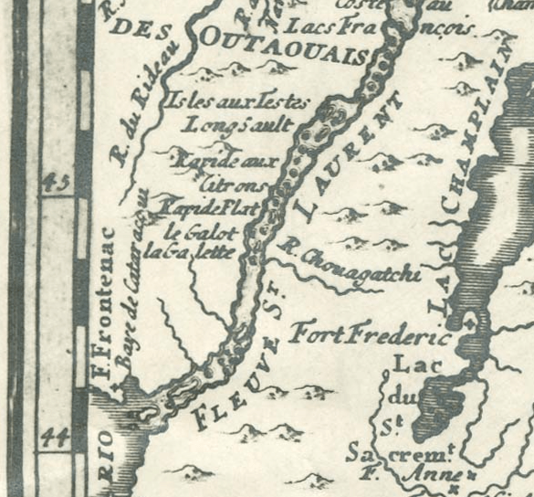
Bought for $60 at a flea market, this 1757 French map shows a mysterious village called “Toniata”.
I left the flea market with an almost 300 year old map of the St. Lawrence River, Ottawa River and Lake Ontario! Dated to 1757 this old map was a stunning example of this country’s early explorations and mapmaking. Pouring over this incredible record from the age of Exploration in Canada, I noticed many recognizable villages and settlements in our area, but one stood out as something strange, a place called TONIATA.

“Toniata” is marked to be located south of “La Galetta” which is now Prescott, across from Ogdensburg, which is marked as “La Presentation” and Fort Francis.
Marked to be somewhere between Prescott and Gananoque on the north shore of the St. Lawrence, this village is clearly marked but I have never heard of such a place. Where did it go? A quick Google search revealed that this is regarded as “one of the great mysteries of early Canadian history” No one has been able to provide “the identification of the site of a First Nations village or camp known as Toniata.”
A school is named after this mystery village in Brockville, and their website clearly notes the oddity:
“From Champlain’s exploration of the Upper St. Lawrence, until the British captured Quebec, maps showed a spot named Toniata. This area was defined as being placed halfway between present day Ogdensburg and the Gananoque River. The name, which had various spellings on the old French maps, seemed to disappear as the British maps replaced the French maps.”
This general area would be as shown in the current Google Map below. Possible location marked with red marker.

Checking my own collection of old map references, Toniata appears on most 17th century French maps, with variations in spelling. Some maps call it ‘Tonthata”, others, “Toniata”.

This map from 1656 by Nicolas Sanson clearly shows a place called Tonthata.

Toniata clearly marked as “Village Of Iroquois” on this map by John Mitchell “Map of The British and French Dominions in North America” circa 1757.

One map calls it “Toniata Village of The Iroquois.” Further research revealed that there is an account called “Memoir Upon the Late War in North America, Between the French and English, 1755-60: Followed by Observations Upon the Theatre of Actual War, and by New Details Concerning the Manners and Customs of the Indians ; with Topographical Maps, Volume 2 by Pierre Pouchot, January 1, 1866” that describes how Toniata was south of Galots, or what is now Prescott, and how Toniata was a very distinct place of reference.
In 1654, Pere Simon le Moyne, a Jesuit priest, made the first recorded voyage of a European through the upper St. Lawrence. He was sent from Montreal to establish a mission at Oswego, NY. Along the way, he stopped at the village of Toniata where he observed native Indians fishing for eel.

An account of exploration on the St. Lawrence that mentions Toniata.
Then, mysteriously, the maps after 1759 no longer mention the village.
Toniata vanishes from maps, but yet La Galette remains.
Further research shows there was once a body of water called “Toniata River”. This river could be an important clue in locating the lost village, yet no rivers are called Toniata River today. It seems that is because its name was changed from Toniata River to Jones Creek after the British arrived in the 1700s. When the French arrived to the Thousand Islands region of the St. Lawrence River in the mid-1600s, they had named the small river Toniata River, being near the village of Toniata. The French described a village of aboriginal people, an area of eight miles adjacent to what is now called Jones Creek.
So, now we have a massive clue that will tell us where the lost village may be located, we just need to find Jones Creek. A visit to Google Maps and the McGill Digital Historical Atlas reveals a likely location.
It seems in the 1700s and 1800s, the Toniata River, or Jones Creek, was settled by Loyalists and made into a milling village known as “Yonge Mills”. Saw mills, grist mills, a hotel, and homes all dotted the area until it also faded from history. The 401 highway was built through the village and nothing now remains of Yonge Mills, or possibly Toniata. This is likely the spot of the original lost village…a quiet river meeting the larger St. Lawrence River. As in most cases in history, an original village is built upon by future inhabitants at a place of strategic and economic importance.

Yonge Mills was a village built on Jones Creek, formerly Toniata River

Mills, and structures marked in red on the river.

Overlaying a current map shows the river has either moved its course, or the old map was inaccurate. Note the 401 highway now goes through the old village of Yonge Mills.
This place is situated on a high rocky plateau on the northeast side of the creek where it commands an impressive view down the mighty St. Lawrence in both directions, a necessary and common trait for a village to be built upon.
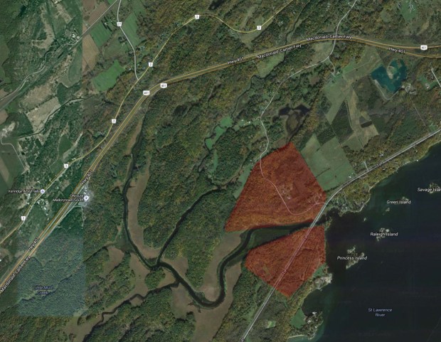
The areas shaded in red are where I believe the lost village of Toniata lies.
Our lost village has likely never been found because the area where it was likely located is in area of undeveloped land, an unexplored area of dense woods where any evidence of the village has likely been consumed by nature.

This area, shaded in red, is the likely resting place of the lost Village Of Toniata.
A small road, Sherwood Springs Road, winds past where the village of Toniata likely once stood 400 years ago, evidence of its bustling happenings lost in time under the leaves and grasses of nature.

A 1600s Iroquois village model diorama (photo: Douglas Sprott)
Perhaps we should let this centuries old village remain quietly hidden, its secrets buried for eternity, or maybe Canadian archeologists would like to explore and unearth its remains, revealing more about early St. Lawrence Iroquois history, a chapter in time that has eluded much study, until possibly now.
Andrew King
December, 2018
SOURCES
Google Maps
Proceedings of the Royal Society of Canada: 1944
Memoir Upon the Late War in North America, Between the French and English, 1755-60: Followed by Observations Upon the Theatre of Actual War, and by New Details Concerning the Manners and Customs of the Indians ; with Topographical Maps, Volume 2, Pierre Pouchot, 1866
McGill Digital Atlas
Historical Atlas Of Canada by Derek Hayes

A marvelous tale. I so enjoy these. I collect legendary and mythical names for my fantasy map. I may include this one as it fits my fancy.
Thank you, another well researched great story. I’m suprised there hasn’t been any on the ground research.
Thanks Steve, it is interesting that there has never been a solid investigation. Cheers!
Andrew,
I am working on a research project and have links to many maps both French and English of that area. I am tracking the route taken by Robert Rogers on a mission for Amherst in 1760. I have 4 years into this project and hopefully will start photographing it this summer.
Your endeavour is great. I enjoyed reading it. Good work, keep digging!
Thanks Jerry! I appreciate you reading my post about it…please keep me up to date on your findings and good luck! -AK
I always look forward to your stories of lost places in time. It is so interesting to learn of ancient villages now disappeared that is at our doorstep. I will think of the Village of Toniata each time I drive on the 401. Maybe this story will spur an interest for archeologists to explore this area and see what they can recover from the past. Thank you again, Andrew, for your excellent research.
Fascinating. I am now engaged in some research about French and Indian Settlement as a result of helping a chum with his own family history research, and it is a part of history I sure didn’t know much about before. Wonderful story. Suggestion: check out early maps at the Library of Congress map division. It is a wonderful resource for historic maps. https://www.loc.gov/maps/ Cheers, BT
Hello Andrew, As always, thank you for your great research and work in bringing to light the past of our area. It really is amazing the information that is there if you just connect the dots. I hope that the area of Toniata is investigated further so we may know more about the people who lived there.
Rosemary Leslie
Thank you Andrew. Excellent read. Thank you Brenda for the historic resource. I look forward to wallowing in it. Happy New year to all.
Thanks for reading and I look forward to having you along on more adventures in 2019!
I would imagine that maps from the 1920s to 1940s might show the remains of Yonge Mills.
True! Got to find them!
Well done, I loved the article. Good use of vague and sometimes not too accurate facts, with careful speculation on them. My experience with old maps is that proportions are often way off. It is hard to measure distances by canoe or on foot in the woods, today, or 400 years ago. The term “league” was not a well defined unit of distance either, A few years ago, myself and a dozen others recreated a trip by Champlain from north of Kingston to Stony Lake near Peterborough on the 400 th anniversary to the day, of his trip. (Oct 28 1615) It is briefly written up in my book “The First Spike” That book is about the early railways, roads, logging, some canoe routes and more, of eastern Ontario. I live in Kingston, not far away.
Hi Steven, Thanks for reading and the mystery continues with only speculation at the lost village location. Sounds like a great trip re-creating Champlain’s voyage…I have written a couple of stories about Champlain on my blog if you type in “Champlain” in my search bar on the blog website. Cheers!
Toniata was one of the borders/boundaries of the infamous Crawford Treaty of 1783, the land treaty which was signed in Kingston and included the section of Eastern Ontario (including the parliament buildings) about which is still disputed today.
As Toniata School in Brockville, will be closing it doors forever in 2023, I have been conducting research into the Lost Village of Toniata. The local Brockville ” Legend “, was that the site where Toniata School sits, was a Native Burial ground. The founding question for writing the History of the school, was: Why would the school board name their new school (1963) after a long lost river, thus Toniata? They must have some notion of the lands significance, to conjure up the name for the school. They also adorned the school with Totem Poles: inside and out. The how and why of the schools naming, indicates some prior knowledge of the old map, and the lost village. As time is of the essence, with the school closing and the property up for sale. This is the time to discover what lies beneath, the school yard.
“This place is situated on a high rocky plateau on the northeast side of the creek where it commands an impressive view down the mighty St. Lawrence in both directions, a necessary and common trait for a village to be built upon.”
Wow! Thanks for this note! I wonder if they will do an archeological assessment of the area if it is to be developed? Would need the proper government channels to be involved. Alas, our history seems to take a back seat.
I just read this story and I live in young mills( across from the church) and found it interesting
Neat! Let me know if you find any relics around there.
There is a lot of inaccurate information and unwarranted speculation here, unfortunately. To put it in the simplest terms: Toniata was the name of the island that today bears the name of Grenadier Island. Through the 17th and early 18th centuries, it was a site of seasonal fishing and encampment for the Haudenosaunee (Iroquois), and of passage on the way up and down the river, but neither the island nor the St. Lawrence’s north shore in this vicinity was the site of a village during this period. The written sources of the period make this perfectly clear. The idea that there was a village there is merely a cartographic fantasy, repeated by a handful of French and British mapmakers who were using each others’ work as source material and lacked any experience of the actual territory or its inhabitants. Your attempt at piercing the mystery of Toniata here sadly falls into the same trap of repeating cartographer’s mistakes, and layering additional layers of unwarranted speculation instead of offering a much needed correction.
Thanks for your input, and as usual, I am not an expert on any of the topics I cover, but merely share the little known facets of history to enlighten those that may be unaware.
I base my writings on the information I research, and allow the reader to continue their interpretation as they wish. Based on my research, I believe there COULD be a lost village in the area I mentioned, and until it can be proven otherwise, I will make that speculation.
Please feel free to write your own account from which others may also learn from if you disagree.
It always bothers me that people like yourself would rather be immediately fire negative comments towards those that investigate the unknown elements of history rather than provide encouraging words and additional info to expand the thought process. Thanks for your input and I’ll file it away with the other detractors.
He my name Timmy Cowie and I can show you where a few settlements from the norses man I believe are all over the Miramichi river but I have found lots of ruin stones all over Doaktown and a few other places thay where here in huge numbers to
Hi Timmy! Thanks for your note and interest in my theory…could you please send photos to the email address on this site and I’d be happy to review them. Appreciate the reply. -AK
It is likely that Toniata was destroyed by the French forces under Governor Denonville in June 1687 on his campaign to establish a French monopoly on the fur trade. He attacked every Iroquois settlement from Montreal to the west end of Lake Erie, which caused the 5 Nations to resettle on the south side of the Great Lakes and strengthen their alliances with the English (thus becoming UEL after the American Revolution). From Fort Frontenac they sent over 200 captives back to Montreal as hostages in case any of their own forces were captured. That number could have included the occupants of Toniata.
Very well done. I agree with you about the location. Some say old maps are inaccurate, and they are, but not that inaccurate. There is often a grain of truth in them, whether or not they got the topography right, or the distances accurate. The diagram of Toniata showing bluffs to the northeast, and southwest fits perfectly and it is consistent with the need for a village to be ‘fortified’ in terms of keeping an eye out for people coming up or down the river. Grenadier Island doesn’t have that advantage…the only area of it that provides a view is the west end where the light station is. Jones Creek also provides a lot of advantages…sheltered bay, creek flowing into a large river (fish) (there are always fishermen at the mouth), level land spacious enough to accommodate a lot of dwellings, and maybe more importantly, access to the north and northwest. The creek goes all the way up to flatlands at Mallorytown and beyond. To the east through Yonge Mills and over to Lynn. So it would have been a natural portage route, though a small one. You’ve convinced me (former Thousand Islands N.P. supt.). And I see on the map my wife’s ancestor (W (for Winthrop) Tufts, living there. I always wondered where his farm was, and now I know and can pop over and have a look. Thanks for your article. Norm
Thanks, Norm, glad you enjoyed the article and hopefully someday the mystery is solved! -AK