Three hundred and sixty years ago, a vicious battle took place on the Ottawa River, a battle so epic that both history and folklore intertwined to create an enduring legend. It was a significant skirmish called “The Battle of Long Sault” which took place in this country’s formative years in 1660, and it occurred halfway between Ottawa and Montreal on the shores of the Ottawa River. It was a brutal battle that would later mold a Quebec folk hero by the name of ADAM DOLLARD.
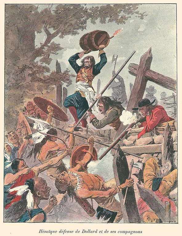
A typical representation of Dollard’s Last Stand.
Yet the exact location of where this historic battle took place has never been determined. Recent research into the matter has uncovered compelling evidence of a quietly shelved archeological dig that took place in the 1950s indicating that the famous battle did not take place in Quebec but rather in Ontario.
BACKGROUND
One of Canadian history’s most glorified battles, The Battle Of Long Sault has been heavily engrained into Quebec cultural history, its central hero being Adam Dollard des Ormeaux. Finely crafted into a heroic figure of French-Canadian culture, he represents idyllic French Canadian nationalism and staunch Catholicism. Yet, some research brings up key evidence that may reveal his tragic story ended in Ontario and not in Quebec as the textbooks would have us believe.

A massive memorial stature to Dollard and the Battle Of Long Sault in Montreal. (Wikipedia)
The May 24th weekend, or Victoria Day for the rest of Canada, is a bit different in Quebec where it is unofficially known as “Fête de Dollard”, in recognition of this character he will soon discuss. In 2003, provincial legislation officially declared the date to be National Patriots’ Day. A central figure of this Quebec patriotism is a young man named Adam Dollard des Ormeaux, a 25-year-old commander of Montreal’s (then called Ville-Marie) garrison. In April of 1660, Dollard requested permission from Governor Paul Chomedey de Maisonneuve to take an expedition up the Ottawa River towards present day Ottawa to attack a war party of Iroquois before they could reach Ville-Marie and its few hundred inhabitants. Dollard believed that many Iroquois warriors who were encamped along the Ottawa River were preparing to destroy the French settlements at Ville-Marie, Quebec City and Trois-Rivières.
Dollard said he could surprise and ambush the Iroquois warriors before they could begin their campaign against New France. After assembling a force of sixteen volunteer riflemen and four Algonquin warriors, including Chief Mituvemeg, the expedition left Montreal in late April of 1660 with several canoes, filled with food, ammunition and weapons.
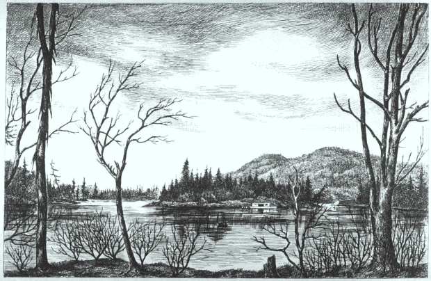
The rapids of Long Sault on the Ottawa River, pre-flooding.
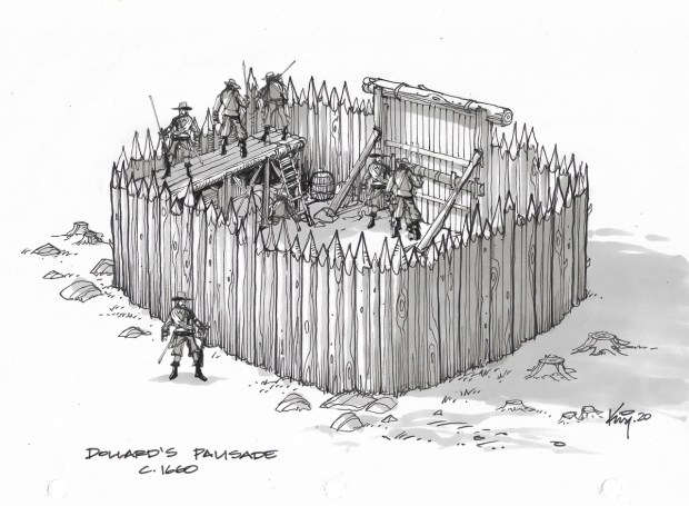
Fighting the strong current of the Ottawa River, Dollard and his men finally reached their destination in early May, an area thought to be a good place for an ambush of the approaching Iroquois coming downriver from present day Ottawa. At the site he chose there was already an abandoned Algonquin fort built along the river made up of trees planted in a circle, cut down to trunks. Forty Hurons, under Chief Etienne Annahotaha came to this position to assist Dollard with his ambush plans. Dollard wanted to create a strong fortress from which to launch his attack, so he and his men reinforced the old fortification by building a new wooden palisade around the wall of existing tree trunks, but the Iroquois soon arrived before his new fortress could be completed.
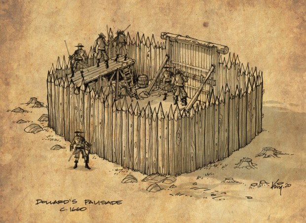
How Dollard’s hastily constructed wooden palisade fort on the Ottawa River might have looked when he and his men built it in 1660. (sketch by author)
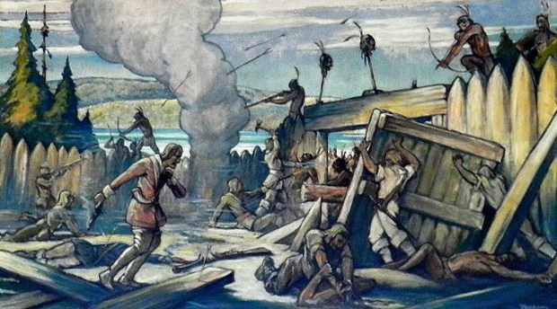
The Iroquois approaching from the west came down the Ottawa River and quickly arrived at Dollard’s position, and in reaction Dollard engaged the Iroquois with musket fire. The result was an immediate assault made upon the fort by the Iroquois, but it was repulsed by the Frenchmen inside. The retreating Iroquois took the French canoes they had left on the beach, broke them up and set them on fire, using the burning wreckage to set ablaze Dollard’s new wooden stronghold. The French and their Huron allies were able to resist the attack and in doing so, killed a chief of the Seneca.
In what was a horrific and brutal scene, the French took the corpse of the Seneca chief and placed his head on a sharpened pole of the palisade as a grim warning to the remaining Iroquois. However, the infuriated Iroquois responded by calling in 500 more warriors to the scene. The Hurons loyal to Dollard, now witnessing the huge army of Iroquois in front of them, decided to defect over to the other side, except for the Huron chief, who loyally remained with Dollard.
The Iroquois wanted revenge and got busy building wooden shields called “mantelets” that were able to repel the firing French musket balls. After a week of back and forth harassment, the final battle began, and now armed with their shields, knives and axes, the Iroquois chopped through the fort’s walls and started pouring into Dollard’s wooden stronghold.
A painting depicting the gruesome end scene of the battle and the eventual demise of Dollard and his men.
Sensing imminent defeat, Dollard then ignited a keg of gunpowder inside the walls of his fort and prepared to hurl it down on the Iroquois attackers, but when the bomb left his hands, it struck the palisade wall, bounced back and exploded in his own fort. With the overwhelming Iroquois forces now inside his walls, Dollard and the defenders were quickly killed in a gruesome skirmish that left only 4 Frenchmen alive, three of them quickly burned alive within the fort, and a fourth being taken prisoner, later tortured and killed. Fearing more intense battle bloodshed ahead, the Iroquois decided to pull back their planned attack and retreated west to Ottawa, deciding it wise not to unleash more havoc in Ville-Marie where the French likely had more muskets and cannons.
Dollard was defeated and the Iroquois achieved their revenge, but the history books say that the young Frenchman managed to scare off the attacking Iroquois, saving Ville-Marie and the rest of New France from imminent bloodshed.
A HERO IS BORN
Native survivors of the epic battle on the Ottawa River then recounted the tale back in Ville-Marie (Montreal). The courageous tale of Dollard des Ormeaux and his men was then recounted to Catholic nuns who decided Dollard should became a heroic figure in New France, a hero who exemplified selfless personal sacrifice, a martyr for the church, and the colony.
In the 1800s The Catholic Church had become an influential representative of French Canadian interests within Canada, and to create an ideal moral and cultural hero, the Catholic church wrote their version of history with an emphasis on Christian heroes, which included the story of Dollard.
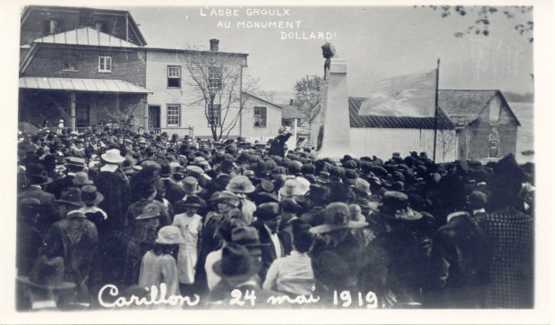
Dedicating a memorial to Dollard in 1919 in Carillon, despite any proof the battle actually took place there.
So it comes as no surprise that in 1919 a small town in Quebec called Carillon was chosen as the spot to dedicate a massive memorial to Dollard on what was decided to be the battleground site and Dollard’s final resting place. However, the location was picked purely at random because it fit a certain narrative and was thought to be in the general vicinity of where this historic battle occurred. Good enough. No evidence was ever found of the battle ever taking place at that location, but it was symbolic a place as any to celebrate Dollard’s heroism, so the memorial was built. However, it seems evidence was eventually found, but it placed Dollard and his fort in Ontario…
THE FORT IS IN ONTARIO
After piquing my interest in learning where this historic fort might be located, I came across a journal article published in 1960, entitled “The Lost Battleground Of Long Sault” by National Museum of Canada archeologist Thomas E. Lee, who weirdly published his report through the University of Rome. Reading the report, it clearly outlines an extensive archeological dig done by Lee in the 1950s that indeed uncovered a burnt out palisaded fort…BUT, it was on the Ontario side of the Ottawa River. However, all this new historic evidence was soon conveniently submerged underwater, flooded out when the nearby Carillon Dam was built in 1959.

The report by Thomas Lee who uncovered the archeological remains of the Dollard battle site in the 1950s.
Lee’s detailed investigation notes into the location of Dollard’s fort.
The Carillon Generating Station uses a large dam, which raised the Ottawa River water levels by over 62 feet (19 m) at Carillon and flooded out the rapids of Long-Sault, submerging all evidence of Lee’s archeological find of Dollard’s fort in Ontario.
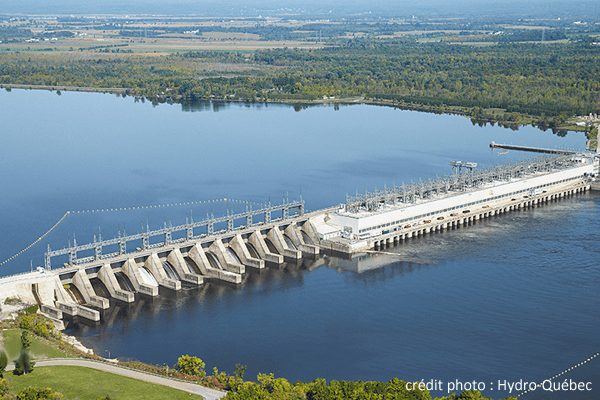
The Carillon Dam that flooded the Ottawa River, and the battlefield site.
After 60 years of being quietly hidden underwater, I will tell you exactly where I think we can find the Lost Fort.
As with many important historic finds, a regular citizen can be attributed to finding this Lost Battleground, and her name was Miss Anne Dewar from Ottawa who had grown up near St. Andrews and had heard stories of an old French fort being on the farm property of a Mr. Ross. The farm, located just below the Little Rideau River and 8 kilometres east of the town of Hawkesbury, was apparently the site of Dollard’s Last Stand.. Dewar approached the museum with her thoughts and persuaded the curator at the time, a Mr. Alcock to join her along with some local French fisherman who also knew of the actual battle site.
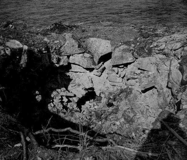
Below: Rare photos of the Lee excavation in Ontario of the fort.
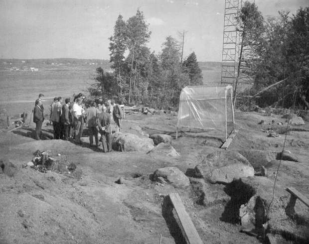
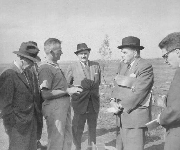
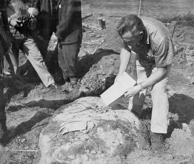
Thomas Lee was then given the go ahead to begin an archeological survey of the site where earthen mounds and rings of earth would reveal a definite fortlike structure. I was able to track down Lee’s photographs of the site before it was submerged underwater for the dam construction, and the evidence Lee uncovered certainly does substantiates Dewar’s claim. Lee of course was met by opposition in the academic quarters who made it clear that Dollard was French hero, who died in Quebec.Yet many older generations in the area adamantly proclaimed the fort was indeed located on the Ross Farm on the Ontario side. Lee also mentions that local indigenous members traveling up and down the Ottawa River often spoke of the old battle at the Ross Farm, as did inhabitants on the Quebec side of the river.
THE LOCATION
Lee began his excavations in 1951 and unearthed the remains of a palisaded structure, which matched the description of the fort where Dollard, his men and countless native warriors perished almost four centuries ago. The fort would have been a rectangular, round-sided palisade, hastily constructed by Dollard, so not a huge size, but big enough to accommodate his men and supplies. Lee’s excavations uncovered quite a remarkable collection of archeological remains, so it was photographed and recorded, but it would soon be submerged under the rising waters of the river when the Carillon Dam was constructed, concealing once and for all the true location of this historic battle.
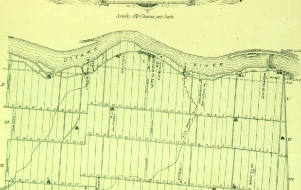
An 1800s map showing the area of the Ross Farm.
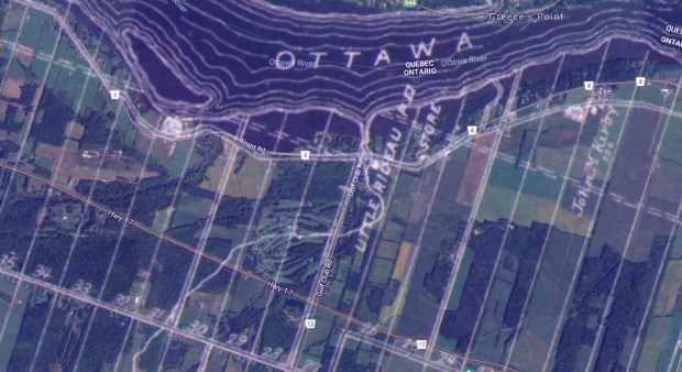
Superimposing the old map with the original shoreline with a current, now flooded river shoreline. Where I believe the battlefield is located indicated in red.
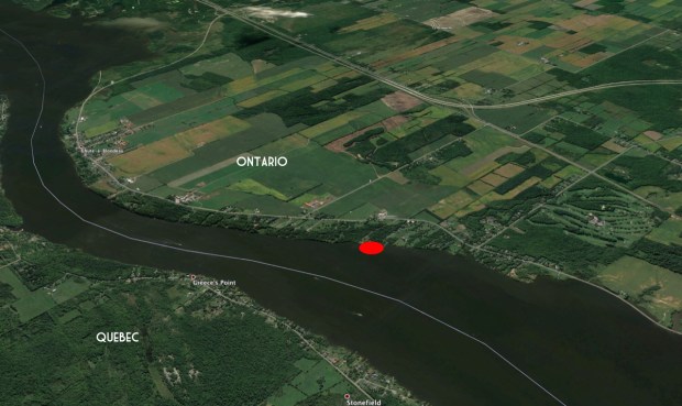
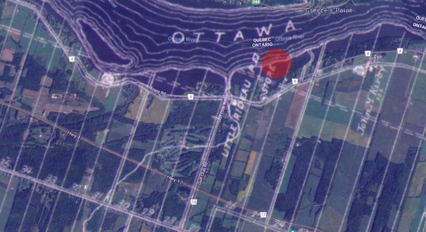
Red circle marks the location of the submerged fort.
Cross referencing historic maps of the area to locate where “The Ross Farm” was located, and using the fact it was said to be 8km east of Hawkesbury, I was able to pinpoint the area where the fort would have been located. Then studying the photographs by Lee, it looks like the fort was constructed quite close to the water’s edge pre-flooding. Since the Ottawa River water levels rose significantly after the dam’s construction, the site is now likely under about 15 feet of water.

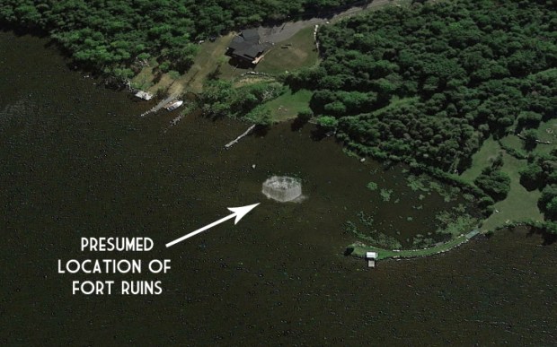
Comparison imagery showing where the fort remains are likely located.
RECONSTRUCTION
Referencing Lee’s notes and the historic accounts of the battle, I sketched how a 17th century wooden palisaded fort may have looked like and then positioned it at the location of where I determined the site to possibly be. It seems to be located about 50 feet off the shoreline of private property, and if that property owner is willing, it might be worth doing some investigation on their property to see if metal detectors could unearth any evidence of the battle in the form of musket balls, arrowheads, knife blades, and any other remaining 17th century artifacts that could have survived. To my knowledge, no further archeological excavations have been conducted, and the site and its secrets remain submerged.
CONCLUSION
I firmly believe that Thomas Lee did in fact uncover the actual site and fort ruins of the Battle Of Long Sault, but whether it is because of old fashioned politics or a lack of funding, interest, or all of the above, the proof needed to confirm this historical event’s location continues to be concealed beneath the waves of the mighty Ottawa River.
Andrew King, February 2020
SOURCES
https://en.wikipedia.org/wiki/Battle_of_Long_Sault
https://www.jstor.org/stable/29787448?seq=1
Google Maps
https://en.wikipedia.org/wiki/Thomas_E._Lee
https://wiki2.org/en/Adam_Dollard_des_Ormeaux#cite_note-lee-5

Hello Andrew, I would be very interested in participating in an official, sanctioned Marine Archeological survey of this site, before it is disturbed by
“Treasure Hunters” I believe this site should be off-limits to the general public, at least until a proper survey can be done so that it is not vacuumed for souvenirs.
Hi Mike, thanks for the interest in this story…and I agree whole heartedly…I have in the past always contacted government representatives regarding my finds to see about getting them properly researched and designated historical sites, but not a single thing has ever been done. Whether it is because I am not an academic, or they don’t care, they ignore my pleas to save these historical sites, and so I write these stories to inform citizens of the important history that lies out there, slowly fading away. It is a shame, but unless we do something first, they will remain “forgotten” in time. If you have the means, let’s do it ourselves.
Andrew, you’ve written an interesting article with a lot of great sketches, photos and maps to further stimulate our imagination. There’s a great deal of history and interesting stories that can be told of life on the Ottawa River over the last 300 years or so. I’m surprised that there isn’t more literature out there, or maybe there is but its just ignored or forgotten. Your short articles are wonderful to get people thinking more about the people and events that shaped our region. Thanks.
A great read, thanks. Those excavation photos are compelling. Interesting how this site is buried by water and political factors.
I love this, Andrew. I paddled from Ottawa to Montreal a few years ago, locking down at Carillon. I wish I had known about this submerged fort then. If I do the trip again, I will make a point of paddling over the area to see what I can see (probably nothing). My nautical charts show Greece’s Point and Chute-a-Blondeau, so I could easily pinpoint the spot. The whole river route is drenched in history. You can feel it as you pass. Thanks for posting this.
Hi Eleanor, thanks for reading…that sounds like quite an adventure I’d love to do some day. Can you email me a pic of the nautical chart of that area? would like to see the depths there…cheers. AK
I emailed 3 pix to your Timewinders gmail account
I love this, Andrew. I paddled from Ottawa to Montreal a few years ago, locking down at Carillon. I wish I had known about this submerged fort then. If I do the trip again, I will make a point of paddling over the area to see what I can see (probably nothing). My nautical charts show Greece’s Point and Chute-a-Blondeau, so I could easily pinpoint the spot. The whole river route is drenched in history. You can feel it as you pass. Thanks for posting this.
Hi Andrew, Montreal-based scuba diver here. I’d love to know if there’s an interest in doing a diving expedition. Is that part of the river “private”?
I dont believe any part of the Ottawa River is private below the waves. Land, above, yes. That would be cool!