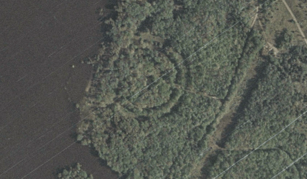
Located in a dense forested area at the confluence of the Ottawa and Carp rivers at the foot of Chats Falls, there lies a hidden 400ft diameter wheel aligned with the Summer Solstice. Whether by coincidence or by conscious effort, someone at some point in history has made a remarkable earthen wheel in what has always been a sacred and important place in the Ottawa Valley.
Further investigation into this overgrown “wheel” reveals interesting details that will either prove it to be of a more ancient origin, or perhaps merely a more modern construction that coincidentally aligns its axis with the setting sun on the Summer Solstice.
In order to learn more about the history of the Summer Solstice and its significance throughout history, we must travel back in time to the early Bronze Age.
HISTORY MYSTERIES
The summer solstice has been significant to almost all cultures, celebrating it as a time of re-birth, and fertility. It is a time of renewal as the sun is at its longest time in the sky. Derived from Latin words, “sol” (sun) and “sistere” (to stand still). Solsistre. Or, as we know it “Solstice”.
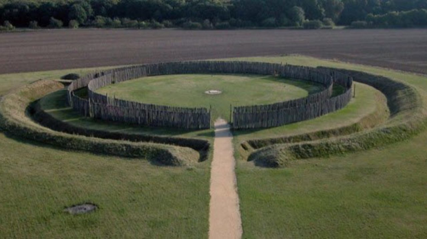
A 7,000-year-old henge with two gates that were aligned with the solstices. The Goseck Circle in Germany is 70 meters (220 ft) in diameter. A circular wooden wall surrounds a narrow ditch.
A sun cross, solar cross, or wheel cross is a solar symbol consisting of an equilateral cross inside a circle. The design is frequently found in the symbolism of prehistoric cultures, particularly during the Neolithic to Bronze Age periods of European prehistory.
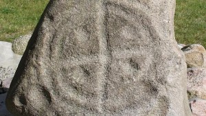
Bronze Age Solar Cross petroglyph in Denmark.
In our current calendar, June 21st marks the day of the annual Summer Solstice. The Christian Church re-branded this special day celebrated by the ancients through pagan ritual as “St. John the Baptist Day”, which occurs 3 days after the solstice event. This date’s relevance harkens back to the pagan practice of sacrifice that occurred on the Summer Solstice. Stonehenge in the United Kingdom is aligned with the summer solstice and to this day thousands gather there to celebrate the dawn on the solstice.
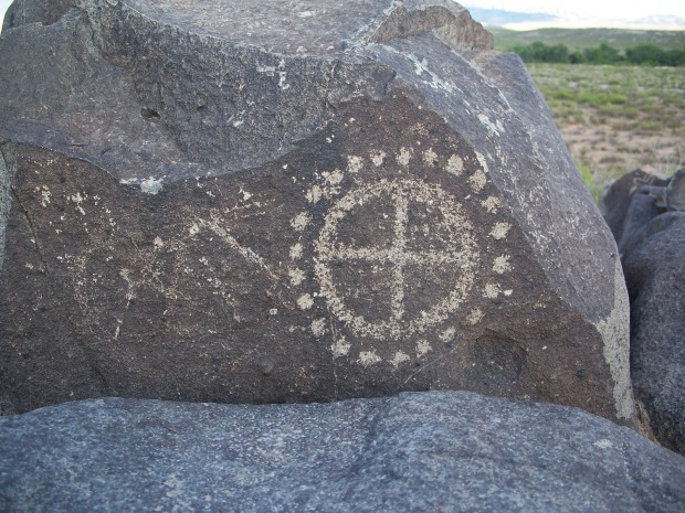
Native American solar cross etched in rock.
Ancient cultures would arrange wood or stones or build earthen mounds in a circular form to coincide with the celestial rotation of the sun. In the Bronze Age, this circle of stones on the landscape would also be illustrated in carved stones with a circle divided into 4 quadrants, denoting the Summer Solstice, the Fall Equinox, The Winter Solstice and then the Spring Equinox. A circle with a cross.
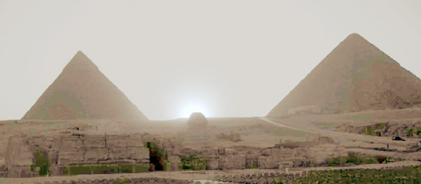
The sun sets perfectly between the two pyramids of Khufu and Khafre on the summer solstice when standing at the Great Sphinx.
The Egyptians built their Great Pyramids in alignment with the equinoxes and solstices as did many other cultures such as the Maya and even North American native cultures.
In North America, this worship of the sun was done using a built structure called a “medicine wheel”.
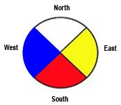
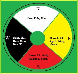
Medicine wheels are used to mark the geographical directions and astronomical events of the sun, moon, some stars, and some planets in relation to the Earth’s horizon at that location. These rock sites were also used for important ceremonies, teachings, and as sacred places to give thanks to the Creator, Gitchi Manitou or Great Spirit. Other North American indigenous peoples also made these circle petroforms (arrangement of stones).
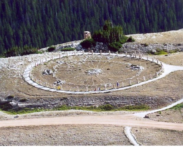
A North American Medicine Wheel.
INVESTIGATION ON THE OTTAWA RIVER
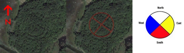
Noticed while examining aerial imagery of the historically significant Chats Falls, it is a place that has been an important confluence for generations of peoples on the Ottawa River. A “wheel shape” that seemed to have a cross, or axis lines within.
Chats Falls has always been a significant area traversed by nomadic tribes of the First Nations for thousands of years to transport goods and copper from Lake Superior east along the Ottawa River, or “Great River” as it was known then. A strategic and cultural area, there is even a native burying ground across from the wheel structure at “Indian Point”. 
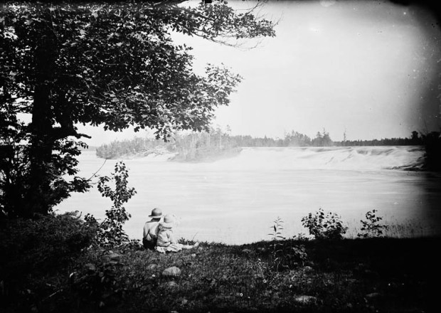
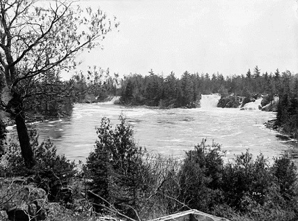
The original, natural Chats Falls before being dammed up for a hydro station in 1930.
So it seems likely that there could have been a concerted effort to build a large structure in this area, and with another ancient Solstice Mound on Rice Lake near Peterborough, it would not be out of the ordinary that something similar would be built on the important Ottawa River.
DETAILS
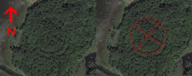
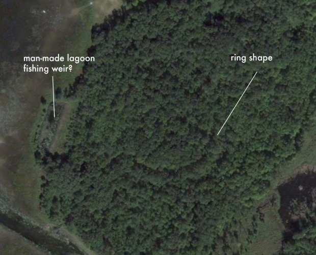
Studying aerial imagery, there is a definite outline of something circular in the forest where the Carp River meets the Ottawa River within Fitzroy Provincial Park. Placing overlays of known “medicine wheels” and “Solar Cross” shapes, they do align with the calculated setting sun axis on the Summer Solstice.
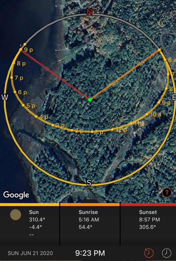
Sun Surveyor showing the axis of one spoke is in alignment with the setting sun on the Summer Solstice (Red Line)
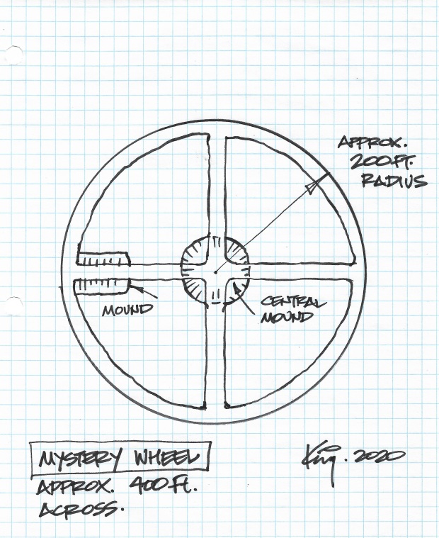
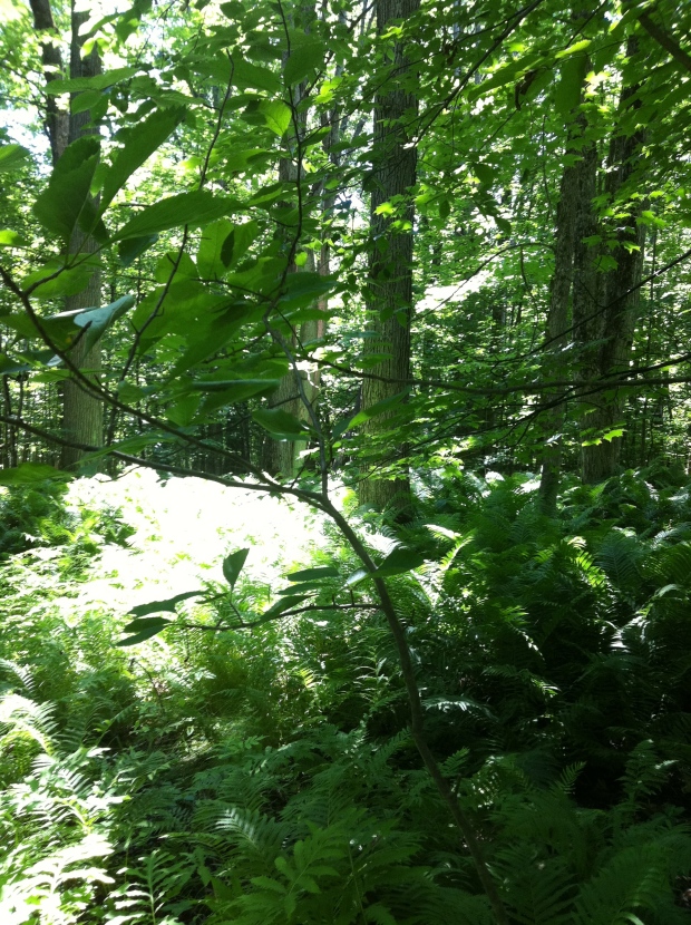
I went to investigate and see this structure in person to examine this anomaly up close and study its details. The area is situated in very dense forest and is in a very swampy, fern covered, low lying area that is likely flooded in the spring. Wet, and damp, there is a definite mounding of earth to create four spokes that converge at a central mound “hub”.
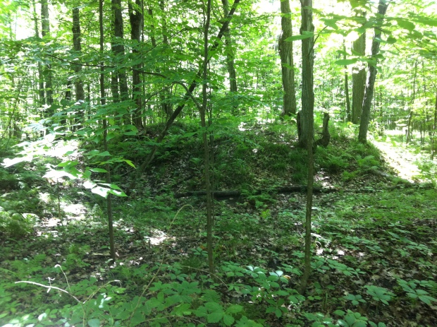
Central mound at centre of the “wheel”

Low lying fern covered grounds around the structure.
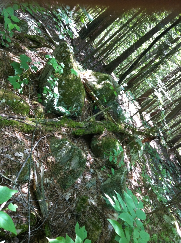
Odd piles of stones were noticeable within the wheel structure.
Another pronounced mound is noticeable on the western spoke edge. Using Sun Surveyor to calculate the position of the sun on the Summer Solstice, one of the spokes is aligned with the setting sun on the June 20-21st solstice event if you were staying on the central mound. It also matches known First Nations Medicine wheels in orientation, and their inherent quadrants of celestial significance.
Also on the nearby shoreline there looks to be a stone weir, purpose unknown. Was this a native fishing camp and the stone weir was used to catch fish as they used to do centuries ago or another modern park feature?
The whole structure is quite peculiar as there are piles of rocks that have been carefully placed in key positions around the wheel in the middle of this dense forest. I have no idea what else it could be except for some provincial park structure from decades ago that has overgrown since. It is quite inaccessible however, and would be an odd park feature for visitors. There are also some substantial sized trees that are quite old.
CONCLUSION
Whether created by an ancient culture during the Bronze Age, or another time to mark the Summer Solstice and other celestial events, or just a weird Provincial Park feature in the middle of a dense forest made just a few years ago, there is giant 400ft diameter earthen and stone wheel on the shore of the Ottawa River at Chats Falls. Perhaps some readers have knowledge of what it was, or is, maybe it is merely an abandoned park dump or something quite logical. But for now, it seems we can safely call it the MYSTERY OF THE SOLAR WHEEL.
Andrew King, June 2020

Andrew, you never fail to stir my interest, great job thank you.
This is fascinating. What scientific investigations have been done?
Fascinating but could this have existed before the dam was built if today the area is flooded in spring?
No idea!
Hi Andrew,
How did you learn of the place? What’s happened since? Do the Algonquins know about it and have they investigated?
It was definitely built before. The dam went in in the 50s. The whole terrain of the park and river were drastically changed with the dam. This area in the photo was actually the entrance to the provincial park before-and campsites. If you walk through there’s still fire grates etc. I own the property directly beside this-our house is in the photos. That man made “weir” is actually the swimming lagoon that the park put in when the primary park beach was at the mouth of the carp-the entrance to the park used to be down stubble road and up our driveway. Funny as I literally walk this area daily and have seen aerial views-never saw this before. Neat aerial photos
Sorry I think maybe I misread your comment… When you said this” I thought you meant the circles… If you’re talking about the lagoon that was put in by the provincial park probably before the damn went in and wind that was the main public beach
If the area is flooded now in spring, what would it have been like before the dam was built?
Really great read, thank you for sharing!
Thanks Ben!
Oh I love stuff like this. thank you for posting it.
thatednks so much for this!
i have discovered extensive stoneworks arranged in a large circle on my wilderness property in quebec. also, a large pyramid mound made up of quartz. i believe these all are ancient and may be related.
https://www.leterrain.land/ancient-ruins-of-leterrain
Neat stuff! Thanks for the link!
As an Algonquin-Metis person, and the author of the book, That Native Thing: Exploring the Medicine Wheel, (Borealis Press, Ottawa, 2010) I would truly love more information about this potential site. I am indeed going to go to Fitzroy Provincial Park to check this area out for myself. If you would please email me back that would be great so I can get more information. When was this area first noticed? Was it by you, yourself, or did others bring it to your attention?
I found out about it on a recent camping trip and checked it out then. Thanks for reading!
The best analysis would be the circle forts as found in Scandinavia. The measurement in diameter seems to be identical. Perhaps the Norse as they explored The Atlantic coast and into the St. Lawrence Seaway could have erected this structure as protection from raiders.
Could you please clarify the timelines you are referring to as there was no Bronze Age in eastern North America.
Hi Liam, the European Bronze Age, which, if you Google it, will reveal it is 3200–600 BC
Aside from the general shape; what would lead you to believe this is a Medicine Wheel? I’m not saying it’s not but my experience leads me to understand that the wheels (especially stone ones) were uncommon east of Saskatchewan.
It was a comparison to one, not saying it could be one…history is constantly evolving and we now know the ancient cultures made celestial aligned monuments in North America.
Have you tried getting old park maps and overlying it? This area was the original camping sites if the park…I wonder if the campsites were laid out this way? As I said-stubble road and my driveway (seen in your photos) was the old entrance to the park. Stones might have been moved out if there’s for paths/sites.
Thanks for the note! I was told the circle was a parking area used by the park…but the mounds are quite steep..not sure how it was used a parking lot.
Hi Andrew,
I read your article and recently read your book on the Serpent mound in Keene, Ontario which I also loved. I live in the Harbour and have studied some of Fitzroy Harbours past. I did an archaeology project on Munroe Island (next to the park) in University a few years ago and have heard that there was been field work done with pottery discovered along the Carp river that meets the Ottawa river. This interesting geological feature came to my attention by Rick Blanchard of the Fitzroy Harbour Historical Society who would be a great resource to find out more. The park holds more secrets! If you ever decide to come back for a future study or have more inquiries, please let me know as I would love to join and share what I know with you. My email is zackaryrobillard7@gmail.com.
Regards,
Zack
Very cool! It had a palpable energy feel to it when I visited…echoing a greater history than I know. Thanks for the note.
Excellent article, anyone interested in trying to protect it?
We have some good LIDAR that I have enhanced. It shows 2 concentric circles to the south and the tongue of rock. Many burial mounds.