The year is 1854 and eight years prior, The Smithsonian Institution was formed in 1846 as a group of museums, education and research centres, created by the U.S. government “for the increase and diffusion of knowledge”. It still operates as a trust instrumentality and is not formally a part of any of the three branches of the federal government.

A representative from the Smithsonian, a Mr. Guest is sent to Canada, specifically Prescott, Ontario to investigate what seems to be a large earthworks formation resembling an ancient fort. Mr. Guest arrives from Ogdensburg, NY. He describes the first site as being “eight miles and a half northwest of Prescott” and containing “mounds and embankments.” He then mentions the presence of four mounds arranged in a rectangle formation, which contain between one and two acres of ground. He says the mounds were up to four feet high. Guest sketched the formation:
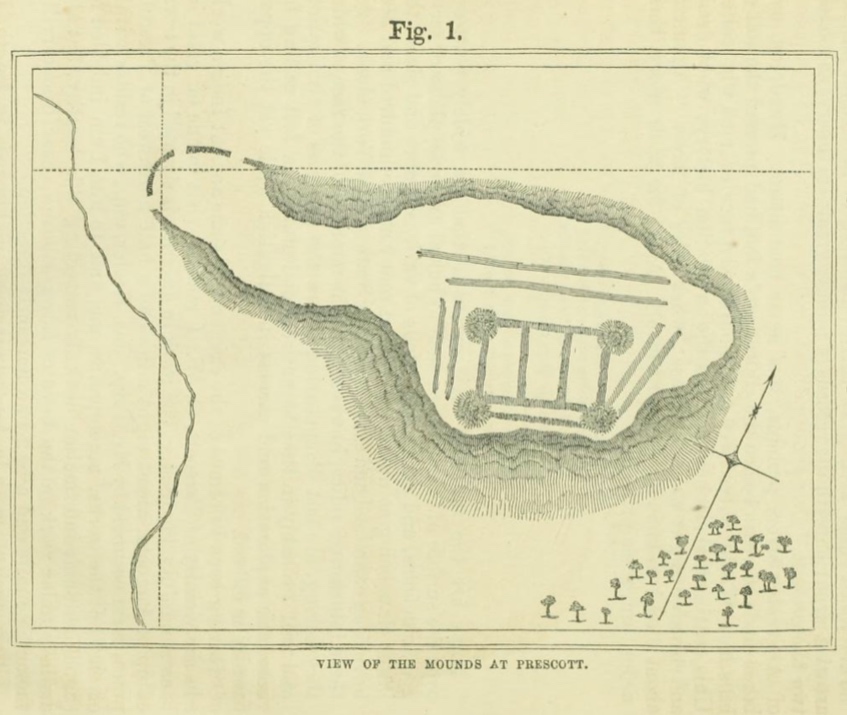
Guest’s map shows what he describes as “a half moon embankment, extending some ten rods across a neck of land, terminating to the north in a swamp, and to the southwest near the edge of a creek. It has three openings, which are from twenty to twenty-five feet wide.
Guest believes the entire “island” of land was artificially constructed out of sand and notices charcoal and ashes; and human bones, pointed bones from the leg of the deer, horns and skulls of the same animals, human skulls and bones of the beaver” as well as: A walrus tooth pendant. Curious, because the Prescott area is not known for its walruses…

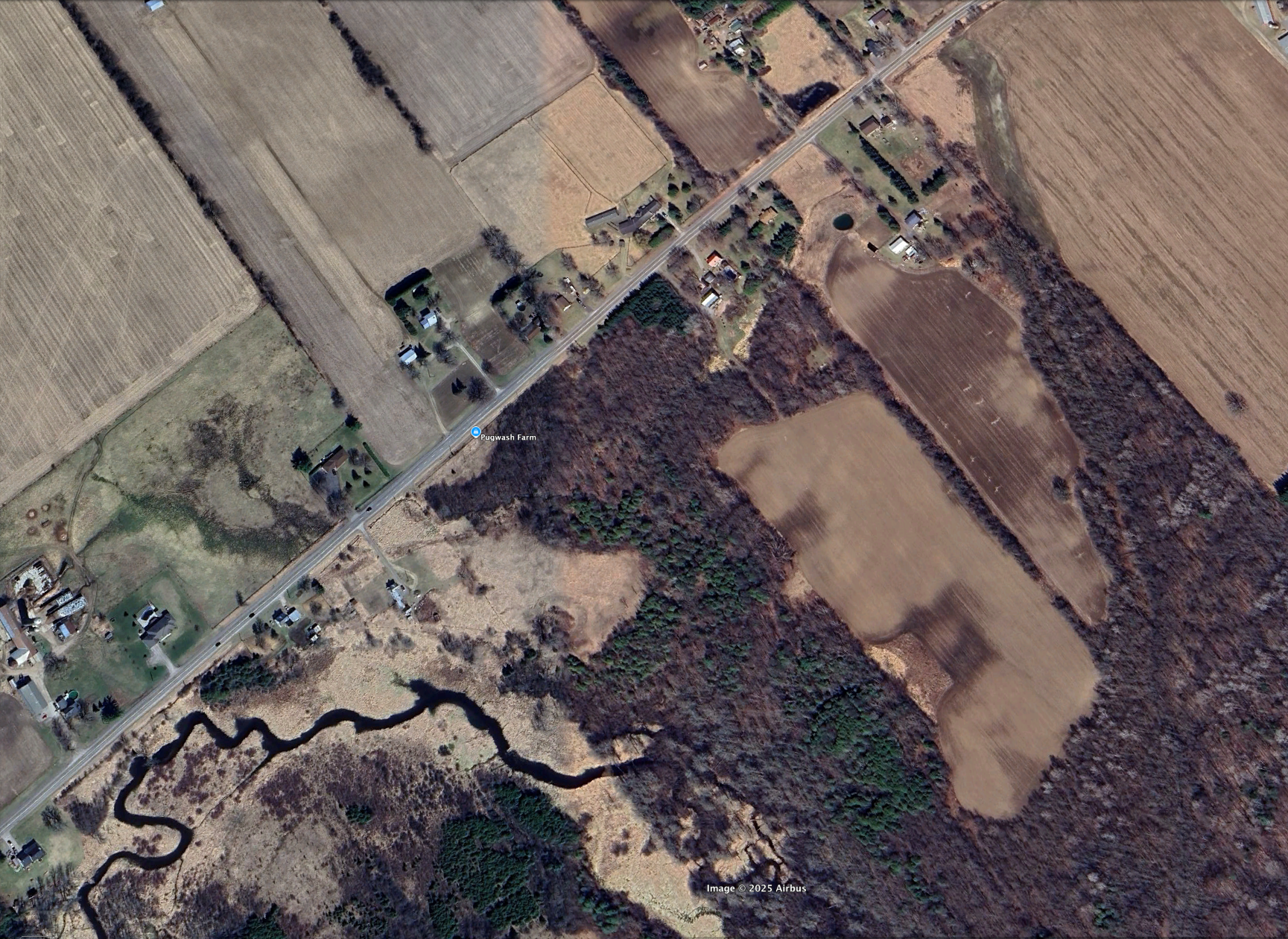
So where exactly is this earthworks formation that the Smithsonian sent Mr.Guest to investigate in 1854? Well, taking the distance Guest mentioned of 8.5miles NW of Prescott, we can set up a general vicinity.
This is remarkably close to another curious site that turned up an unusual European made 15th-16th century bone needle case back in a 1912 archeological dig.

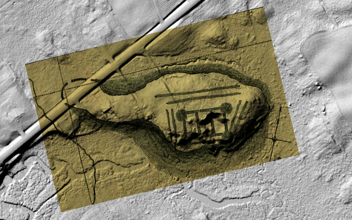
I was able to access the LiDar imagery data of that particular area and transform the map to a surface detail map to see what kind of topography exists and if anything resembles the “island fort” Guest discovered.
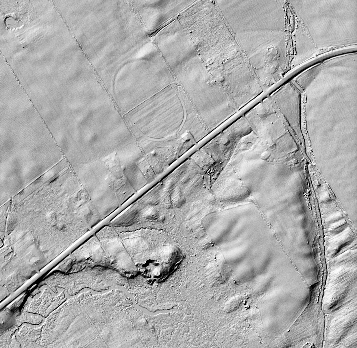
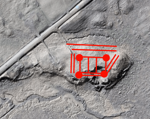
Studying that area Lidar imagery it appears we have a very close match to Guest’s 1854 investigation map, although a modern road has been constructed through its western arm:


To confirm this was the site investigated by Guest, I overlaid a ghost image of the fortress sketch on top of the Lidar image… It’s a pretty good match…
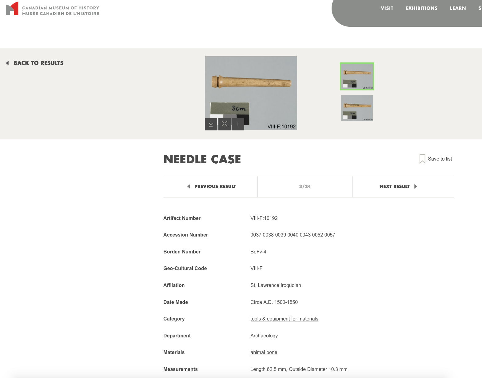
Ok, so we have some kind of earthworks here to investigate…I am familiar with this site, having been introduced to an unusual archeological find here discovered in 1912. An archeologist by the name of Mr. Wintemberg discovered a piece of “carved bone,” that he described as “suspiciously European.” This suspiciously Out Of Place Artifact was then stored away in the Museum of History warehouse where its origin remained a mystery…and its research data has since been removed from the museum database.

Luckily I don’t rely on the Internet for everything and I have acquired the original 1912 archeological report:

And using this report we can get a sense of where and what was found here… Burials. Objects. I can even trace back to 1912 photographs of the site and the massive excavation of this earthworks…


So what was this unusual structure and who built it? It seems the 1912 report doesn’t really know, but attributes it to the St.Lawrence Iroquois. “AGE OF THE SITE The age of the site is unknown and there is no positive evidence pointing to its great antiquity”

I saved the recent report about the European bone needle case found there in 1912, which states that according to former Curator of Central Archaeology at the Canadian Museum of History, Jean-Luc Pilon, the curious bone object was studied in detail and using a small sample taken from the odd cylindrical object & was carbon dated with an accelerator and mass spectrometer. The final results of the dating put the oddity at a date of between 1499 and 1578…and was determined to be a European machine lathed bone needle case for metal sewing needles. Wait, how did a European lathed bone metal needle case get into these earthworks far before Europeans were in the area?
One answer could be that the object was traded between tribes and made its way from the East Coast of North America in the 1500s all the way to this site south of Ottawa. Another theory is that a new European visitor made their way to the site, maybe a lost a castaway from a European expedition, or perhaps an expeditionary group using smaller boats came into the area and left behind objects of their making. The object was found among other dated Iroquois objects of the time which ruled out it was dropped there at a later time. Whatever the “case” may be, literally and figuratively, this object is truly an Out Of Place Artifact, as the indigenous people of that time had neither lathes or metal needles.
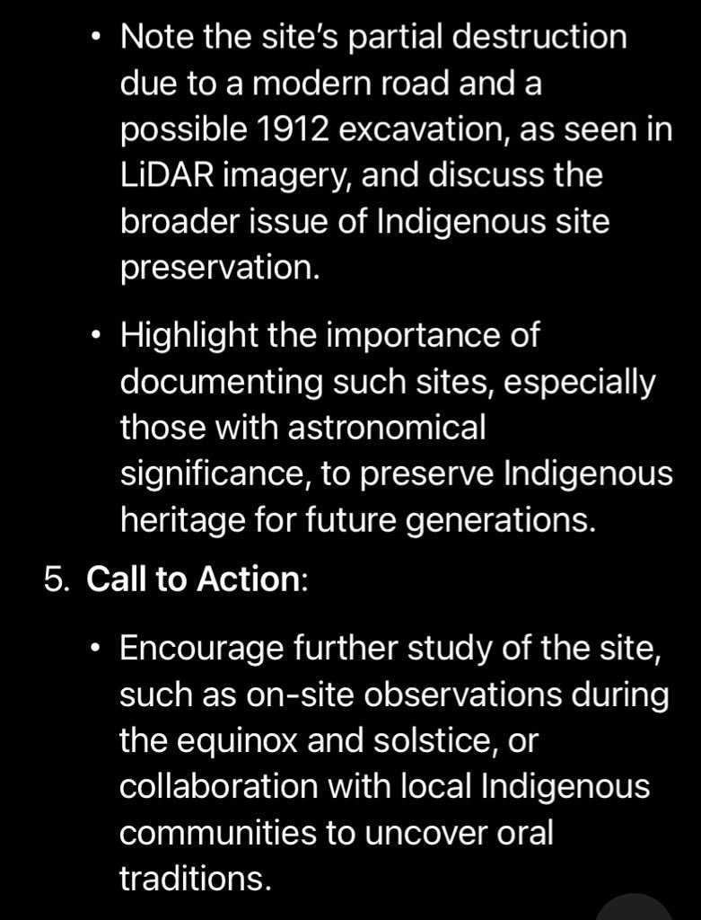
Further examination of the Lidar imagery shows that the original earthworks formation studied by the Smithsonian’s representative, Mr. Guest has been partially destroyed. (Note the crater at bottom) Perhaps from the 1912 excavation?

ANCIENT EARTHWORKS A CELESTIAL OBSERVATION STRUCTURE?
Was this structure an Archaeoastronomical Complex…?
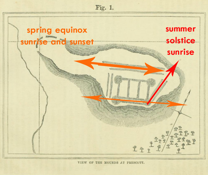
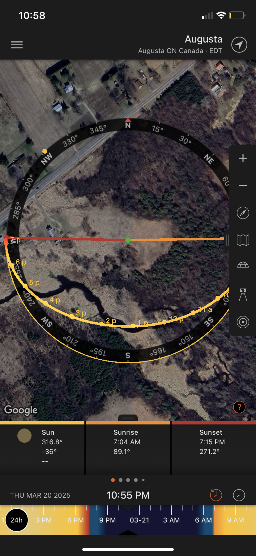
The unusual layout and odd diagonal embankments reminded me of other ancient structures aligned with the Spring Equinox and Summer Solstice…like the ancient mounds in Ohio and the Serpent Mounds. I applied the Sun Surveyor app to the structure and it seems to lean in that direction. The embankments of lines in straight and diagonal positions seem to align with the Spring Equinox and Solstice Sunrise…the circular mounds as observation points.

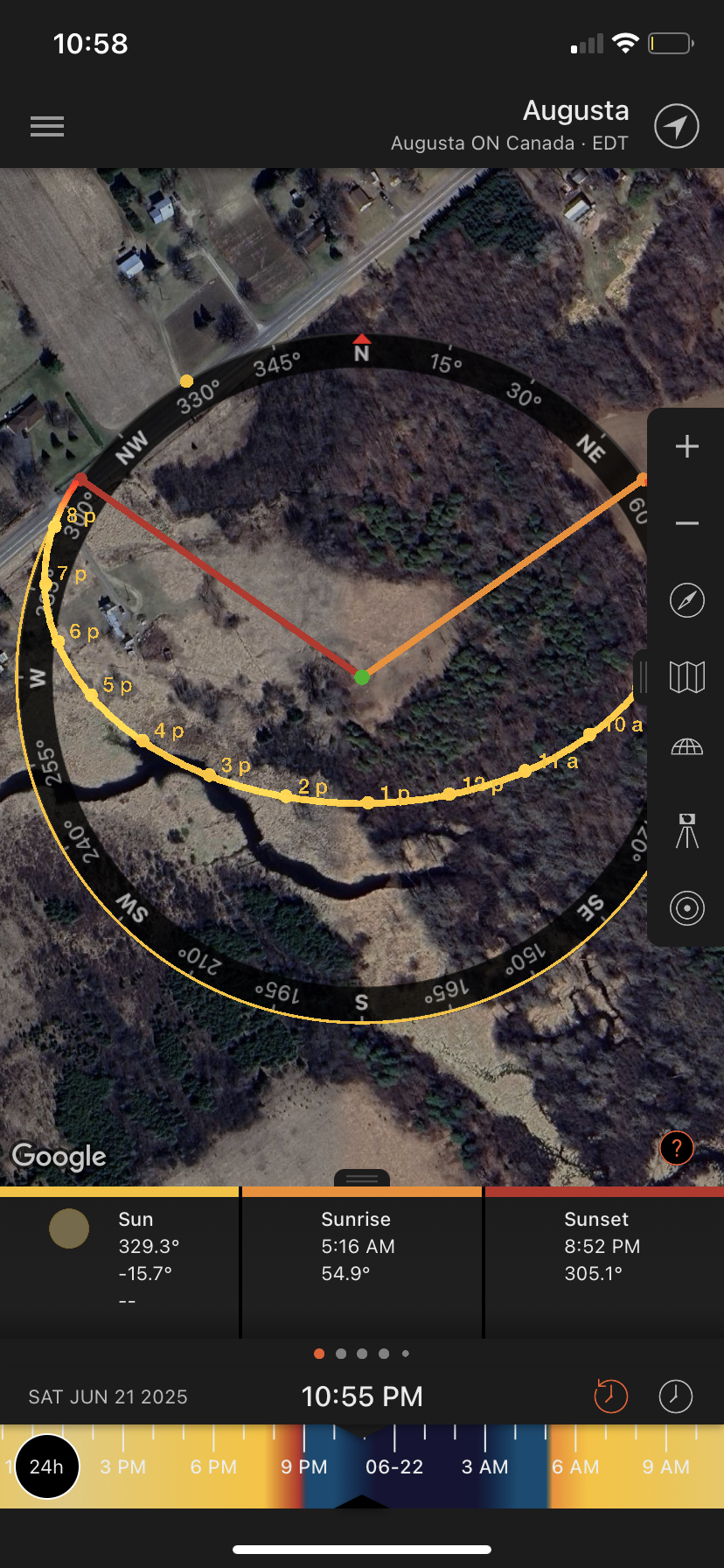
To analyze the data for further confirmation I made an input of the data to Ai Grok to make an analysis. Seems the theory is correct:
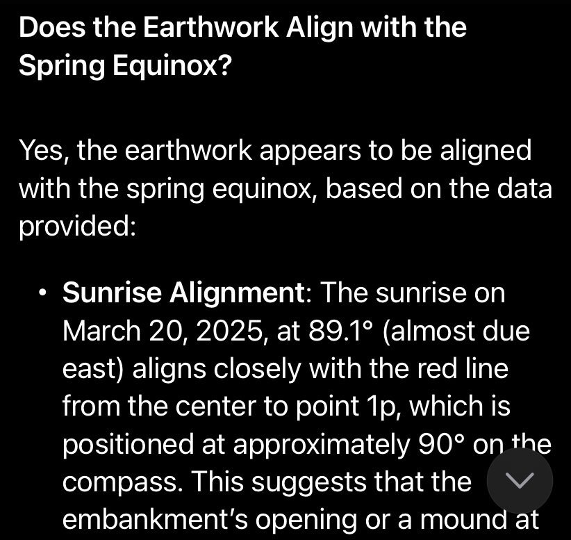
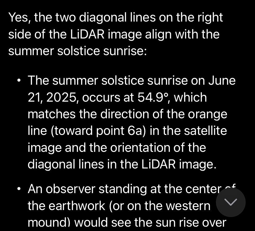
So, it seems that there is an ancient earthworks that was built south of Ottawa that was specifically designed and built to recognize celestial alignments on the equinox and solstice. Grok Ai analysis thinks this warrants further archeological investigation.
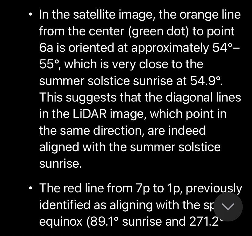
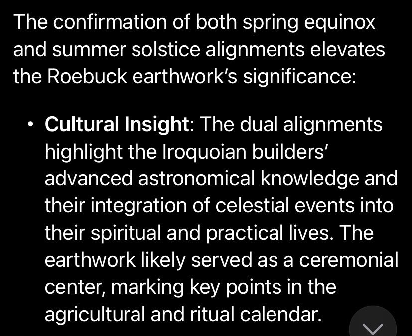
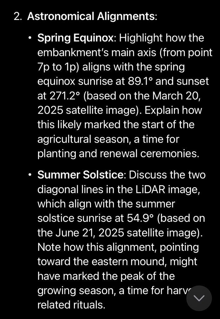
The Ai analysis seems to confirm that the structure was some kind of Celestial Alignment structure that corresponds to the Spring Equinox and Summer Solstice Sunrise.
Whatever the case may be here, there was a highly unusual earthworks formation, made by either ancient Hopewell Mound Builders, or advanced St.Lawrence Iroquois even though they were not known for mound building practices. So who built it? The Ancient Hopewell Mound people of the Adena culture? A local history mystery that deserves further investigation…
Will anyone in the Canadian Govt or its agencies take notice? Will it be ignored and forgotten? Likely, but this is why I am making a record of this data and information to record it for any future prospects. Perhaps someone somewhere will take an interest in what I think was an unusual ancient mound structure that was likely built to observe key moments in our celestial calendar.
Andrew King, March 2025
My thanks to Shane for the map & tip, the Smithsonian, the Govt Of Canada Lidar Mapping, the Museum of History. And Google Maps.

Very interesting,I can imagine this site being used as a ceremonial place marking a seasonal change in hunting patterns , rights of passage and rituals. I wish the government would rebuild and protect some of these interesting sites
Get Outlook for Androidhttps://aka.ms/AAb9ysg
Thanks for reading! -AK
Andrew, this is fascinating work. It is intriguing to speculate about possible contact between Iroquois and Hopewell people. Could a Hopewell tribe have settled in the Prescott region? It would be straightforward to travel there by lake and river from the Ohio Valley. If that is so, there will be other artefacts of theirs to be found. I wonder if Iroquois oral traditions include mention of such a group.
Thanks for a great start to my day.
Eleanor Thomas
Thanks for reading….the Hopewell Mound Builders likely came much earlier than the Iroquois so I’m not sure if they had contact. -AK
Dear Mr. King; Fun article ! I’ve come to believe that somewhere along the ancient Champlain Sea there had to be migration of the early peoples of the Great Lakes Lowlands. I believe as the Sea drained we should be able to find evidence of culture along ancient shore lines. I’m thinking about 7 or 8 thousand bce. and this site has potential in that it could sit at the edge of an ancient inlet. This would account for the middle of nowhere site. Any way–thank you for all the work.. JR.
Thanks very much, the ancient shorelines indeed provide a good explanation for these random places, such as around Rideau Lakes. -AK
Your article on the Earthworks is fascinating! I’m working on the problem of North American topographic data dating to 4-5 KABP which appears on 16th and 17th century European maps. Also trying to trace a canon/swivel gun, excavated from the banks of the Albany River in the 1950’s by Cree hunters and delivered by air to Moosonee for transport to Ottawa, I have not been able to trace that weapon. If you have knowledge of it, the casting marks may be useful in dating and sourcing that gun.
Regards, Carl G. Schuster Chief Pilot The Port Nelson & Shanghai Navigation Company Expeditions 1-212-799-6473
Thanks for reading, I do not have any info on the swivel gun you mention…keep me posted if you find out more! -AK