PART 2 of a two part series examining the mystery of Norse settlements in Canada
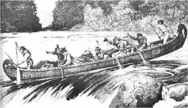
The idea of Norsemen exploring towards the interior of Canada is probably met with the same scepticism as the idea of them once crossing the Atlantic Ocean. Yet that idea was finally proven fact by the Ingstads in the 1960s after what was I’m sure was much controversy. The Ingstads hard work and determination paid off and legend soon became fact. The excavation of the ruins at L’Anse Aux Meadows proved that it was not a permanent settlement, but rather a staging ground for further ventures elsewhere and the out-of-province butternut illustrates something was indeed happening. Whether the butternut was from a far distant land and arrived through trade with the indigenous peoples or that the Norse brought it back with them after a another trip elsewhere into Canada illustrates a deeper interaction within our country than first thought.
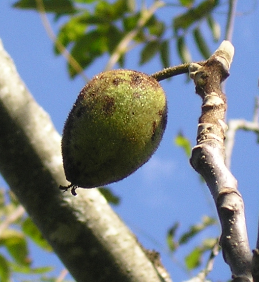
A butternut like the one found at L’Anse Aux Meadows.
The earliest Canadian document I could find exploring the idea of further Norse exploration was Dr. George Lawson’s article from 1884. (see previous post: PART 1) Lawson concluded that the wild grapes that could describe “Vinland” were present on the shores of Lake Ontario west of Kingston (Prince Edward County, currently a popular wine region) the banks of the St. Lawrence in the 1000 islands up to Trois Riviere, QC and the St.John River region in New Brunswick. (we will talk more about the grape regions later)

Dr. George Lawson describes the northern extent of wild grapes in Canada for Norwegian scholars in 1884.


A 2011 map showing extent of wild grapes in Canada.
STONE COLD
In 1812, a stone weighing almost 600 pounds was discovered by a Dr. Fletcher on his property at the mouth of Yarmouth harbour Nova Scotia. Inscribed on the stone were odd carvings that resembled old Norse runic writing. The stone was found near the ruins of an old stone dock and moved to a hotel, then the local library. Then stone then was taken to Norway before WW1 to be admired by the descendants of the stone’s author, later stored in a warehouse in London, England as it was deemed too unsafe to travel across the ocean with it during wartime. After the war ended it returned to Yarmouth where it was put in the local library and later moved to the local Yarmouth Museum where it remains today. It sits in the little museum and it remains to be studied further as authentic evidence the Norse made their way to Yarmouth, Nova Scotia.
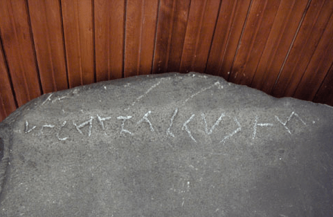
The Yarmouth Stone found in 1812 inscribed in what is thought to be Norse runes. (photo posted with permission of Yarmouth County Museum and Archives)

I contacted the Curator of the museum in Yarmouth to ask permission to publish photos of the rune stone, which they have graciously allowed and it is shown above. Nadine Gates, the Director/Curator of Yarmouth County Museum and Archives (direct link HERE ) emphasized that the museum remains neutral on the stone’s authenticity and states “Please understand that this is NOT a confirmed “Viking” stone. This is but one of several theories surrounding the rune stone found by Dr. Fletcher in 1812.” The stone currently remains in the county museum and has yet to be verified as authentic evidence of Norse visitation to the region.
SPEAR OF DESTINY
In 1929 the owner of a summer home near Sodus Bay, NY was repairing his breakwater after a heavy storm washed away some of his property and was trying to find a suitable place to rebuild his boathouse. The property owner, Augustus Hoffman, was excavating his land and unearthed an object found about twenty feet from shore.

Location of where an authentic Norse spearhead was found. (Bing Maps)

Hoffman picked up the iron object that he assumed was an old Indian tool and tossed it aside. A year later Hoffman showed the iron object to a friend who in turn contacted the Royal Ontario Museum in Toronto across the Lake Ontario. The object was confirmed to be an authentic Norse iron spearhead with an age that ranged from the ninth century to the fourteenth century. The Norse spearhead now resides in the Museum of Wayne County History, NY where it rests as an authentic Viking spear with its reasons for being there unknown.
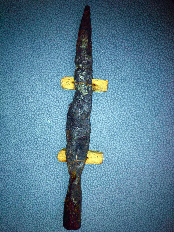
The iron spear head of Norse origin dated to 9th-14th century now in Wayne County Museum

Sodus Bay (red) due south of Prince Edward County on the shore of Lake Ontario where the spear was found.
Was it a lost relic from a a Norse exploration party who traversed the St. Lawrence river into Lake Ontario to Sodus Bay on the south shore? Or was it a traded item through indigenous tribes that somehow made it all the way from LAM? Its location is almost due south of Prince Edward County.
MORE BEARDS
Almost at the same time as the Sodus Spear discovery, James Dodd, a CNR trainman in Port Arthur was prospecting near Beardmore, ON and uncovered something that continues to be a controversial piece of Viking lore . While prospecting for gold in 1931 Dodd claims he unearthed some old metal and like Hoffman of Sodus Bay, thought they were some “old Indian relics” and took them home where they sat for five years. Dodd later contacted the Royal Ontario Museum and the curator at the time took a closer look at them with great interest as they resembled not ‘Indian” relics” but that of the Norse. The curator, Charles Currelly bought the items for $500 off of Dodd and sent photos of the relics to Europe for analysis to see if they resembled anything from the Norse culture. They were indeed authenticated as genuine Norse articatcts: A Viking Sword, A Viking axe and a Viking Shield handle. 100% legitimate Norse artifacts.
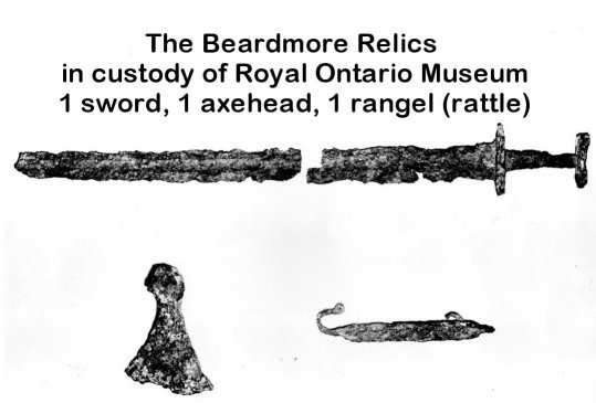
The museum proudly displayed them soon afterwards as genuine proof of Vikings visiting Ontario but soon academics and archeologists questioned the provenance of the artefacts and accused Dodd of planting the objects. The museum, in an effort to avoid controversy removed the Viking relics from their display and put them in storage for almost 30 years. No one was allowed to photograph them. Dodd’s son, Walter, later was told to give a sworn statement in 1957 that the objects were planted by his father and they remained in storage until about the 1990s when they reappeared in the museum with no mention of their checkered past. They remain in the museum to this day in the “weapons” wing, and last winter I had an opportunity to see them in person. They are indeed heavily corroded iron artifacts on display without any of the history behind them, but using previously published photos of the relics I was able to identify them in the display case. They are shown below.

The Beardmore relics are displayed in ROM without mention of their discovery or how they got there.

The actual Beardmore Viking Sword as displayed at ROM. No mention of its illustrious past described, marked only with “Distinctive Norwegian Blade 775-900AD”

The Viking axe from the Beardmore relics on display with mention of its past noticably absent.

Description of the Beardmore axe in the ROM display case.
1950s FINDS
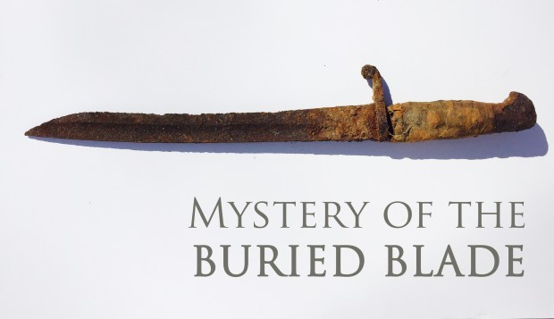
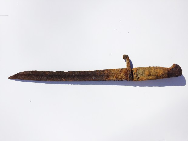
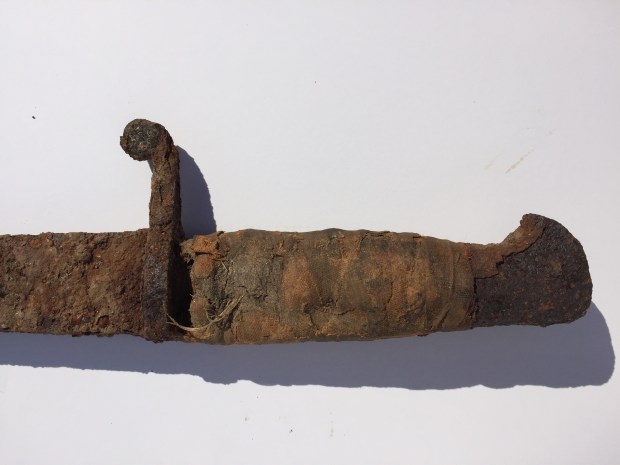
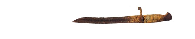
Another Norse discovery was made in Aillik, Labrador when a Viking sword was found in a remote outpost on the coast of Labrador in 1953. A newspaper article of the time reports the find but I have been unable to determine what happened to the sword and whether or not it was authenticated. Perhaps it still lies in storage somewhere.
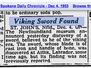
Newspaper article describing a Viking sword found in Aillik, Labrador.
A few years later in 1957 Guy Mellgren, a local resident and amateur archaeologist, found a coin on August 18, 1957 in Brooklin, Maine. At first, like the previous finds, it was not thought to be Norse. It was thought to be a British penny from the 12th century. In 1978, experts from London considered that it might be of Norse origin. Today the identity of the Maine Penny was been authenticated by Kolbjorn Skaare of the University of Oslo who determined the coin had been minted between 1065 and 1080 AD. The penny was discovered with a hole in it that indicates it was probably used as a pendant of some sort, most likely by the indigenous people of Maine at the time it was being circulated by the Norse. The Norse penny currently resides in the Maine State Museum.
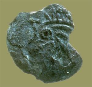
The Maine Penny. (photo Maine State Museum)
The Norse coin is thought to have ended up in Maine through native trading channels, coming down the coast from the Norse settlement at LAM. No Norse pennies have ever been found at LAM.
MOUNDS OF MYSTERY
In the same year the Maine Penny was discovered an archeologist from ROM travelled to Rainy Lake, Onatrio where he excavated a series of unusual mounds. Walter Kenyon visited the mounds and I was able to acquire his complete report on the 1957 excavation of the mounds that are located 250 km west of Thunder Bay on the border of Minnesota and Ontario. Of particular interest is Kenyon’s excavation of a large mound structure on Oak Point Island. Kenyon in his report on the find explains the mound showed evidence of intrusive burials, that is, someone had dug into an existing mound and put their own own bodies and items into it. As Kenyon unearthed the mound he discovered large angular rocks positioned with two burials and a number of items that present a curious collection of artefacts.
 Kenyon uncovered an iron axe, that was used as a hammer at some point, its head being distorted. Also uncovered were a finger ring, a twisted strand copper bracelet, thirteen thimbles, a copper spring, metal “ornaments” and a variety of other artifacts that included glass beads of various designs. Kenyon photographed and documented each item which was included in the archeological report but he gives no indication of their origin or why they are in a mound other than the fact there were a number of skeletal remains also discovered within. With the L’anse Aux Meadows site yet to be discovered, perhaps Kenyon wanted to play it safe and not make any speculation.
Examining these artifacts Kenyon unearthed I noticed some odd similatires to artifacts I had seen while visiting the Viking exhibit at the Museum Of History. There were strikingly similar details so I have placed them side by side in comparison for you to review for yourself and come to your own conclusions. This could be pure coincidence, and represent items from a different time period. It is also unknown where these artifacts are today. Do they rest in some storage container in the ROM warehouse, shoved away to never again be displayed for the public to see? It would seem logical to try and date these items and figure out their origins. Until then, we will have to settle for the accepted view that they are of native origin or from a much later date.


Kenyon also includes in his report a mention of the mounds in Prince Edward County discovered and studied by Thomas Wallbridge in 1860. Acquiring a copy of Wallbridge’s 1860 report on his findings of odd mounds in “The Canadian Journal Of Industry, Science and Art- 1860″ as part of the Smithsonian Institution collection, Wallbridge notes that before the native Iroquois that once roamed the region, there were “traces of a more ancient race”.

The 1860 archeological report describing Wallbridge’s examination of unusual mounds in Prince Edward County.
The fascinating entry in the journal remarks on how some “race” had erected works in Prince Edward County unnoticed, which became the subject of the first documented archaeological report in Ontario. Wallbridge noted that 100 mounds existed in Prince Edward County, and they occurred in groups of two on the shores of water. Upon excavating one of the mounds Wallbridge discovered a limestone box made up of flat stones, within which skeletons were found sitting in an upright position with folded arms.


Viking burial mounds in Scandanavia as shown at the Viking exhibit at the Museum Of History.
Wallbridge concludes his report by saying “Whatever be the origin of these remains, it is clear that the Massassaga Indians were not the builders of the works which they are entombed, since this tribe, it is well known, buried their dead in wrapped birch bark, and laid them at full length a few inches beneath the surface of the soil,” Wallbridge is perplexed at the whole series of mounds, and insists “the skeletons found in the sitting posture belong to some other and far earlier race.”

Wallbridge’s sketches of his examination of the ancient mounds in Prince Edward County.
Curious to view these mounds that lie within a short distance of my family’s home, I visited the Prince Edward County site to see for myself what characteristics they may have to give up some possible clues as to their purpose. The Ontario Archeology Report, 2001, Number 72, Page 38 has a thorough analysis of the mounds and striking similarities between those in PEC and mounds in Europe are given along with a comprehensive look at their possible function. Mapping out where the mounds may be located, I indeed came across the unusual mounds and recorded my finds. They are situated in close proximity to the shore of Lake Ontario facing east in groups of two. The mounds are about 20-ft in diameter and are about 8ft in height. The pair of mounds with their centre points connected with a line align to the rising sun in the east. Without permission or proper tools to investigate the mounds further, no other evidence was uncovered but these fascinating ancient structures demand further investigation by the proper institutions of historical research.

I explored the area Wallbridge described the mounds to be located in PEC and came across unusual mound shapes.
Kenyon then concludes his report on the mounds he found in an almost similar tone, noting most of the mounds were near water, the same situation in western Europe. Burial mounds in Europe were arranged around fjords or bays on high ground with views of the sea. The mounds found in Ontario share the same characteristics with Bronze Age burial mounds in Europe and those on the Orkney Islands off the United Kingdom. Is it pure coincidence that two entirely different cultures shared an almost identical mound building practice separated by the Atlantic Ocean? Perhaps they met and exchanged cultural practices that carried on for generations to come. It remains a curious mystery that the mounds generally contain another type of inner burial chamber with an outer indigenous intrusive burial on the top layer of the mound. One wonders if visitors of a different race at a different time as Wallbridge speculates first built the mounds and then they were later used for other burials practices by a future society. Again, without proper analysis that seems to be absent this can never be determined.
CURRENT DISCOVERIES
With most of the aforementioned Viking and related remnants having been discovered in the mid 20th century, it seems the whole Norse exploration mystery has remained on a simmering back burner for years. As our attention turns towards a more colonial French and Bristish occupation history of early Canada, these earlier visitations seem to go unnoticed and lack any further investigation. More recently the discovery of the butternut at LAM again opened the debate that Norse visitors ventured elsewhere in Canada and in 2012 the National Geographic published an article about the Norse in Canada after the curator of Arctic archeology at The Canadian Museum Of History (then called the Canadian Museum of Civilization) Patricia Sutherland discovered what is thought to be a Norse outpost on Baffin Island. Sutherland was abruptly fired for what was stated to be “harassment issues” in April 2012, (Ottawa Citizen article HERE) just months before her Arctic research was featured in National Geographic magazine, but her research is still available for viewing on the museum website HERE.
Another National Geographic Magazine article describes scientists found more than 80 living Icelanders with a genetic variation similar to one found mostly in Native Americans after analyzing a type of DNA passed only from mother to child. This would mean that a Native American joined someone from Iceland in North America, hopped aboard their ship and returned with them to procreate within Iceland. Brigitta Wallace who has written much about the Norse in Canada and is an archaeologist for Parks Canada has said that in the The Saga of Erik the Red four Skraeling boys (a Norse term for Native Americans) were captured by an Icelandic expedition and taken back to Greenland. This does not make it implausible a female was also brought back with the Vikings on their expeditions into Canada and has resulted in a DNA variation that combines Native American with Icelandic genes. It is interesting to note that no Inuit DNA shares any Norse DNA.
BUTTERNUTS AND BOOZE
With evidence mounting that Norse explorers ventured elsewhere in Canada other than LAM, we can start to piece together a picture of what may have happened and the possible routes they may have taken. Compiling the locations of known relics (hoaxes or not) and the known areas where butternuts and wild grapes do indeed grow and have grown, we can create a map of possible exploration by our Norse visitors.

Range of butternuts.

Extent of butternuts along the St. Lawrence River and Lake Ontario.

Butternuts also occur along the St. John river in New Brunswick.
With butternuts occurring along the southern part of the St. Lawrence River and into the shore regions of Lake Ontario as well as the interior of New Brunswick along the St. John River, and matching that with the area of wild grapes, a map of possibilities can be constructed. With projected exploration areas outlined, we can then “connect the dots” on certain routes and plot them out to determine where, if any, remains of Viking outposts or visitations may lie.

Possible Norse exploration routes.
This narrows down the areas to either be in New Brusnwick or along the St. Lawrence River, areas where the Norse acquired the butternuts and grapes they took back to LAM. The existence of authentic Norse artifacts can not be denied, it is just figuring out how they got there that remains a mystery. trading with the indigenous tribes of the time is the accepted theory, but it seems odd these Norse items would make their way inland while none of these same items were ever found at LAM. It is not common practice for the Vikings to trade their weapon items with the native population, so how would they acquire them? Through conflict? Norse visitors may have come into Ontario further than we had thought possible. It is hard to request an investigation into these areas unknown without concrete evidence but if we look back on the speculation of the Ingstads in 1960 they proved to the world that legend can indeed be fact. Perhaps with the directed research and investigation into these projected areas we can prove once again an important part of Canadian, and ultimately, world history.


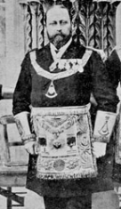
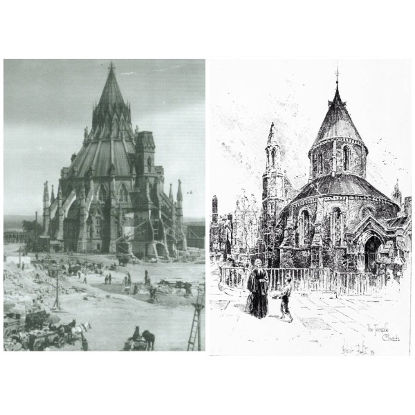
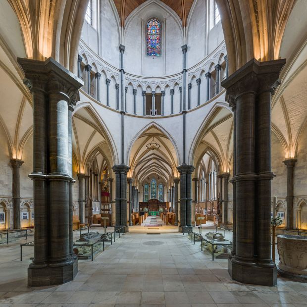
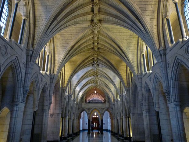
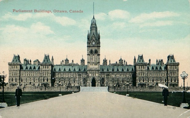
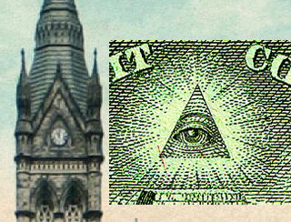
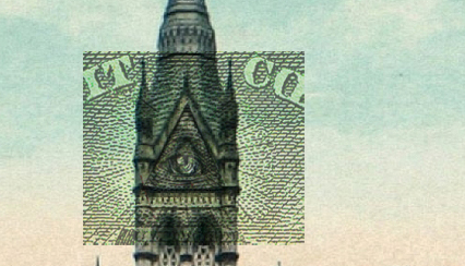
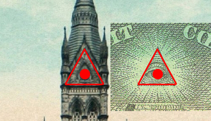
 Today marks the 100th Anniversary of Canada’s original Parliament Buildings being destroyed in a fire that swept through the structure on February 3 1916. All that remains today of the original Parliament structure is the Library of Parliament, a unique round building at the rear of the current Centre Block. Designed by Thomas Fuller, an architect and member of the Freemasons, the original buildings have a unique connection to an ancient Order and their secret symbology.