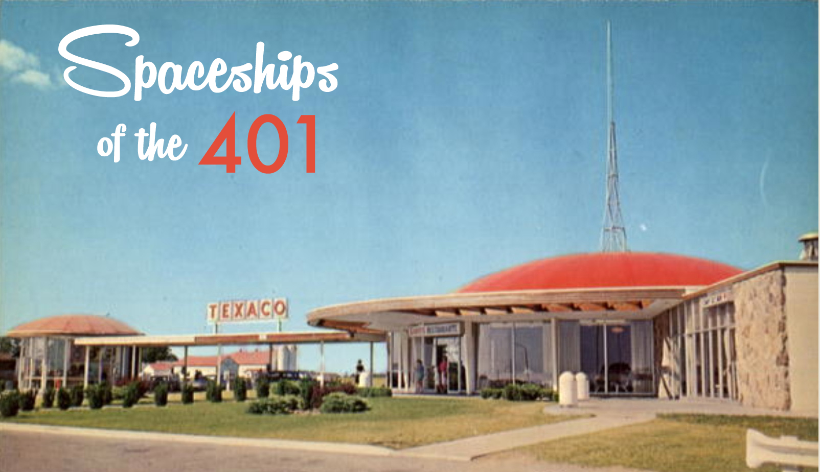
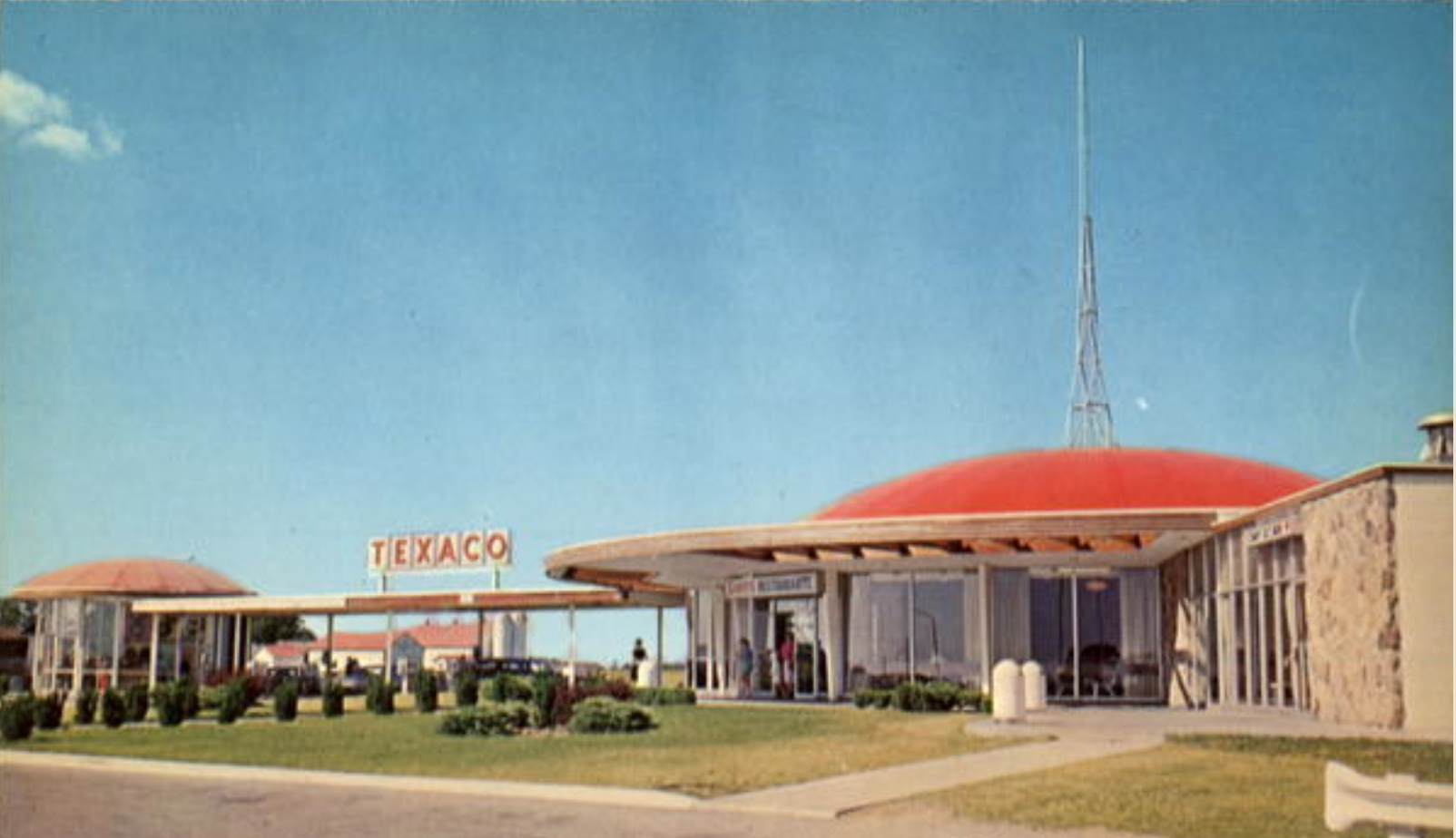
A recent drive back to my hometown along the 401 highway brought back memories of the same trip 30 years earlier with my family in our little Volkswagen Beetle. Like most family road trips in the late 1970s we’d stop in at one of the rest stops along the 401 to go to the bathroom, grab a bite to eat and fuel up the tank. Spending less than few minutes at these rest stops, I now think I took for granted what was a remarkable piece of lost architecture.
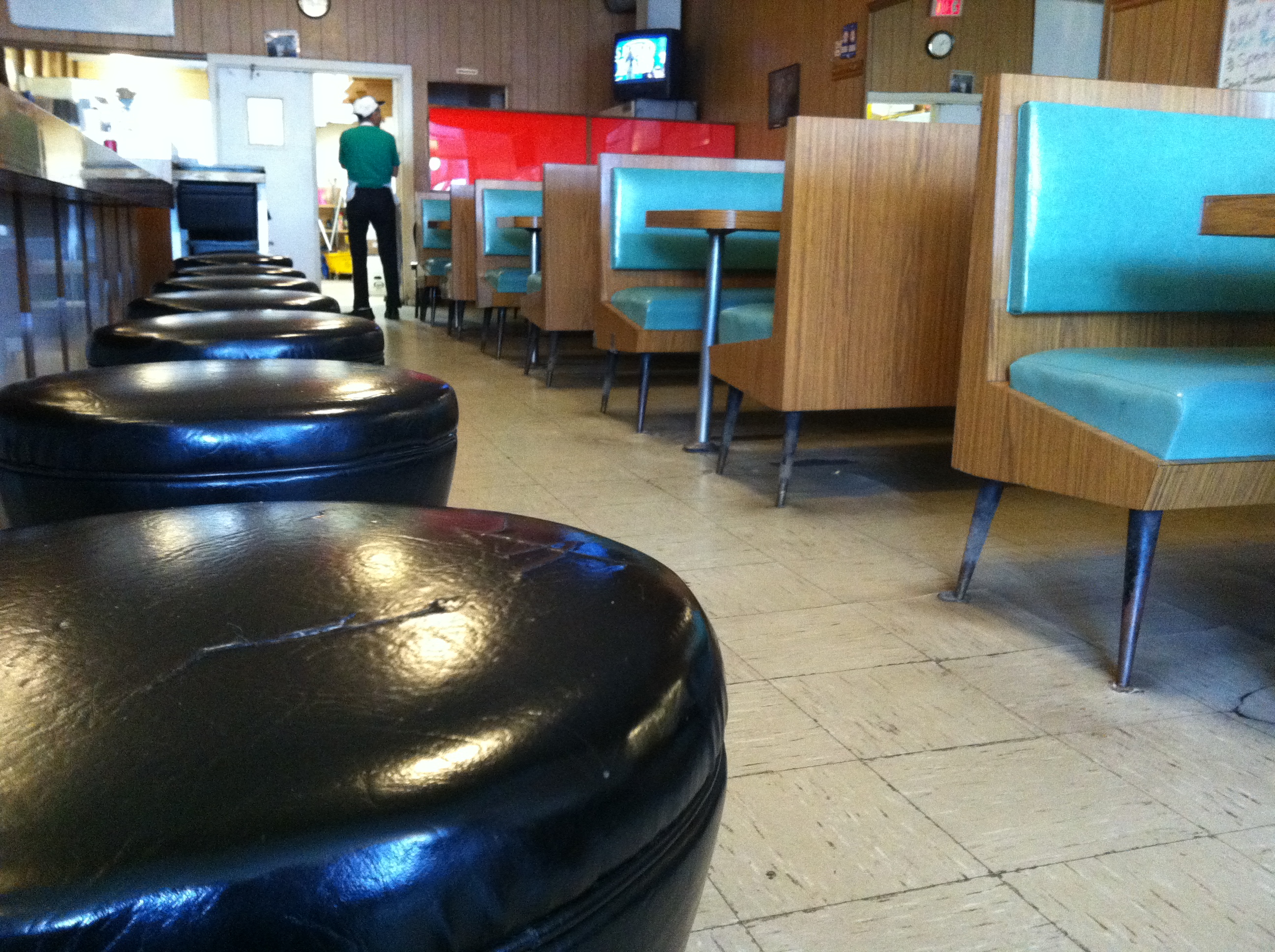
My re-collection of these rest stops was of a unique dome shape that I distinctly remember as a 10 year old kid. Of course, the ten year old me could care less about the architecture at the time, my thoughts were more focused on the green Jello in the glass display cases housed underneath this great domed 401 oasis. With fond memories of these restaurants with their vinyl clad fake wood panelled booths and smell of sizzling burgers, I hoped to re-visit one of these places, but unfortunately they have all been recently demolished and replaced with the new, modern “On Route” rest stops.
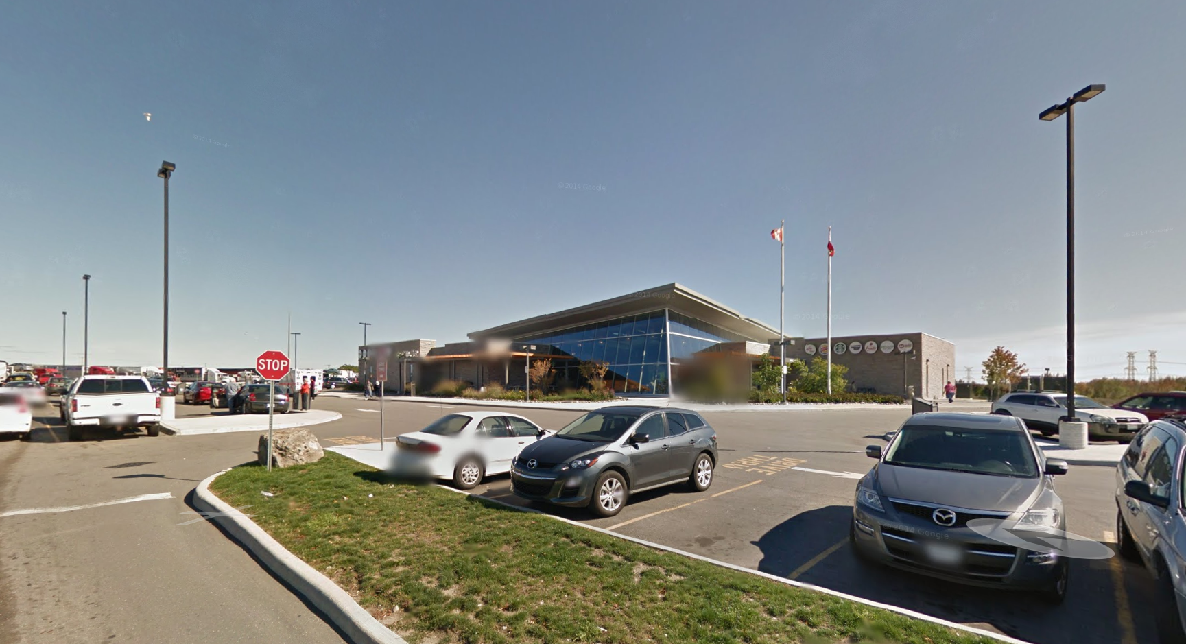
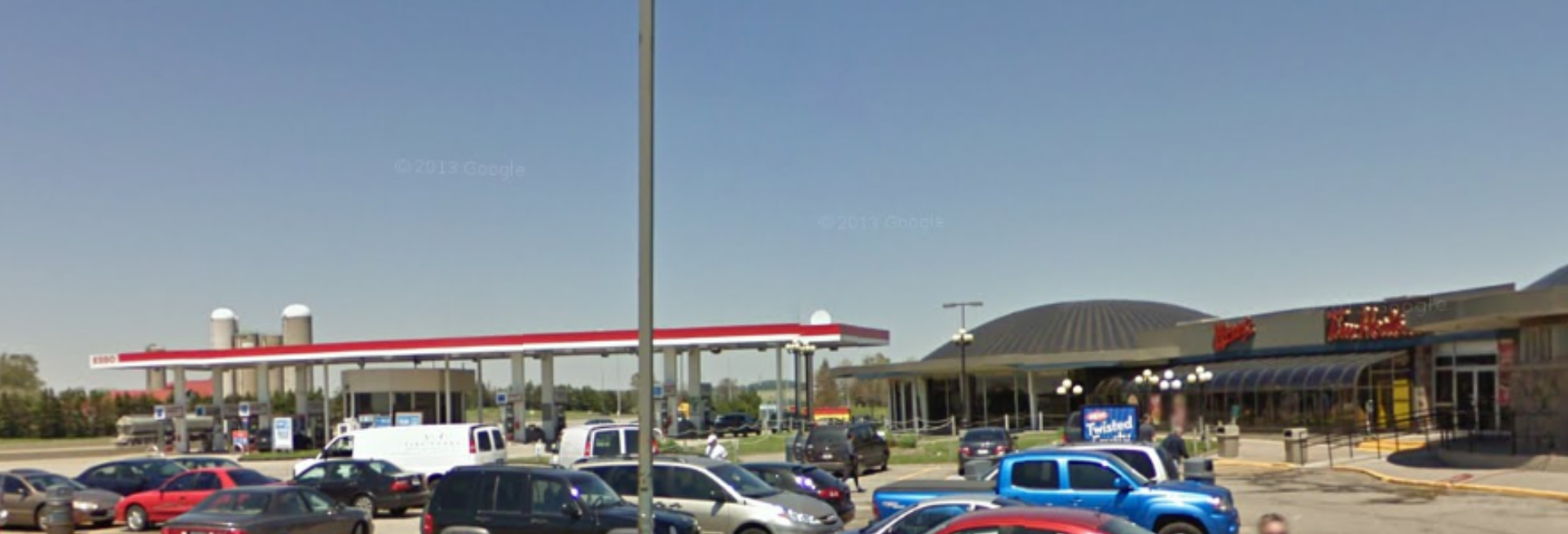
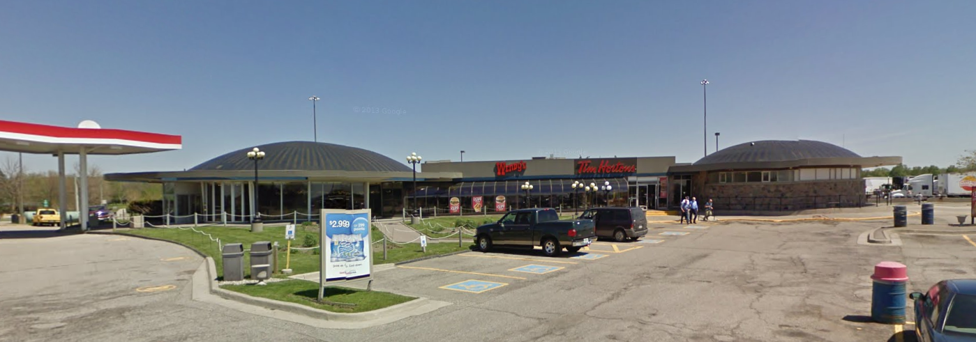
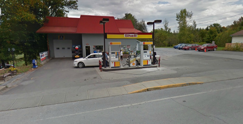
This new OnRoute rest stop in Port Hope replaces the original domed “spaceship” design that was demolished at this location. (photo: Google Streetview)
There is little record of these once grand domed rest stops, but I did manage to find some background info on what I think was an important part of our Canadian culture and a unique architectural icon.
These unusual rest stops, looking somewhat like a landed UFO, were designed by a Toronto architect by the name of Harry B. Kohl. Kohl was one of the premiere architects of the 1960s, having designed cutting edge pre-fab model homes for the National Home Show. After graduating from University of Toronto in 1947 Kohl designed a number of homes, apartment towers and eventually, the Millhaven Maximum Security Penitentiary . Kohl died in 1973, but many of his designs still live on in the Greater Toronto Area.
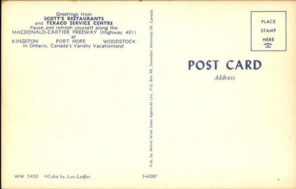
A 1960s postcard of a Kohl’s rest stop describes locations in Kingston, Port Hope and Woodstock.
Kohl was into the use of architectural geodesic domes, of which he incorporated into his design for the 401 rest stops that he was awarded in the early 1960s when the newly built 401 highway system was opened. Kohl believed circular shapes accommodated the circulation of people better than square shapes, and his designs, including the 401 rest stops, reflect this theory.
A 1960’s postcard of Kohl’s domed spaceship rest stop in Woodstock, On
The same rest stop, drastically altered from the original. Note same farm in background. (photo: Google Streetview)
A closer view of the 2009 version of Kohl’s rest stop. (photo: Google Streetview)
Built of wood and stone in typical mid-century modern fashion, Kohl designed his 401 rest stops in a unique shape with a domed red roof that included a tall spire to catch the attention of passing motorists. Teaming up with the Texaco Oil Company, Kohl’s rest stops were completed in 1962 and usually contained a restaurant that was either an independent diner with typical 1960s decor, or a Scott’s Chicken Villa Kentucky Fried Chicken, as the case was at the Kingston, Port Hope and Woodstock locations.
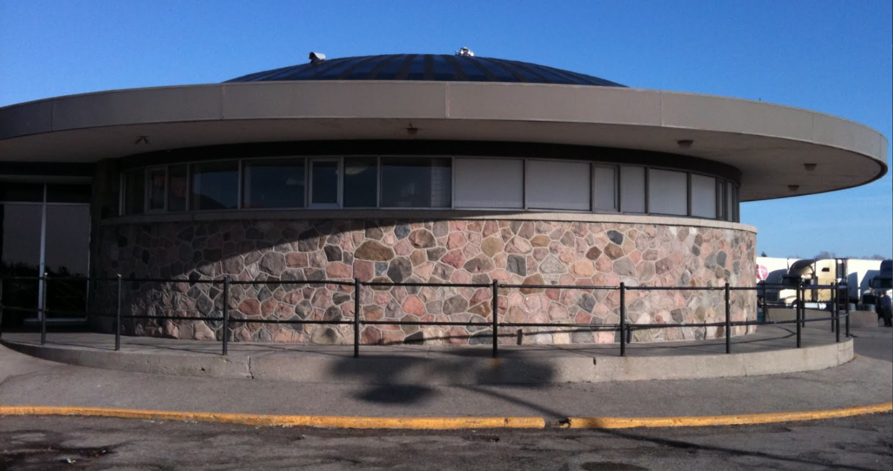
Detail of stonework on Kohl’s rest stop. (photo: Google StreetView)
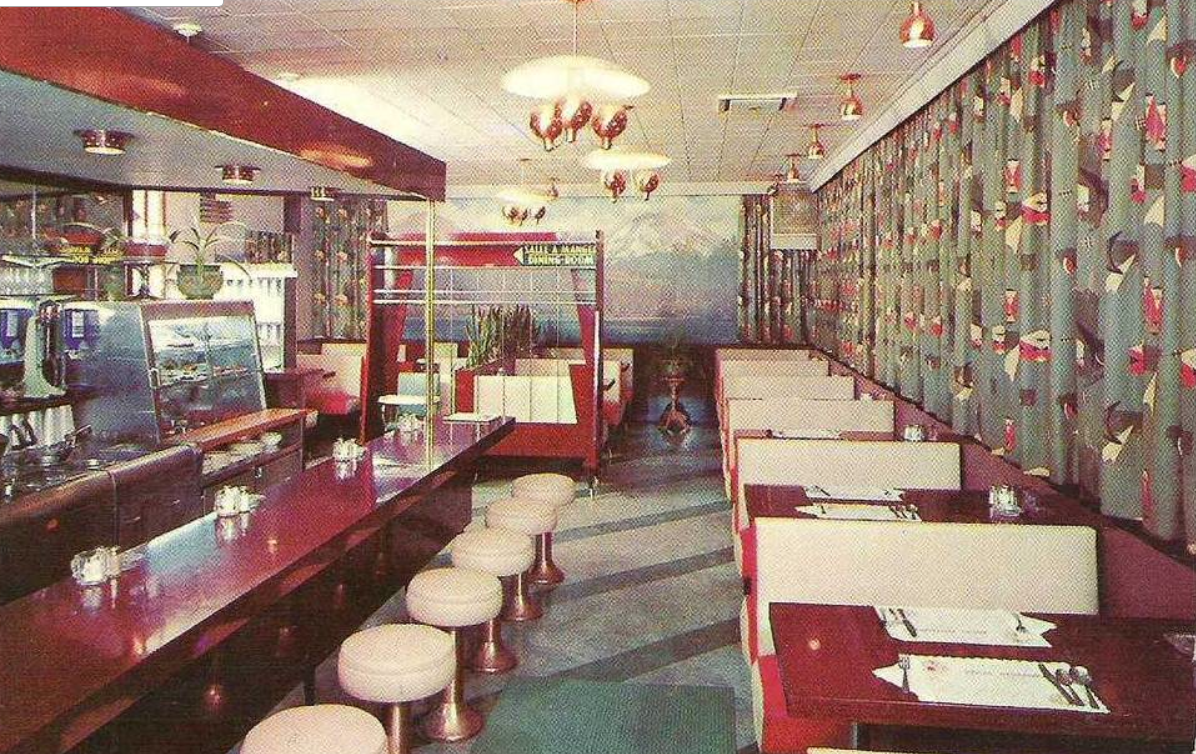
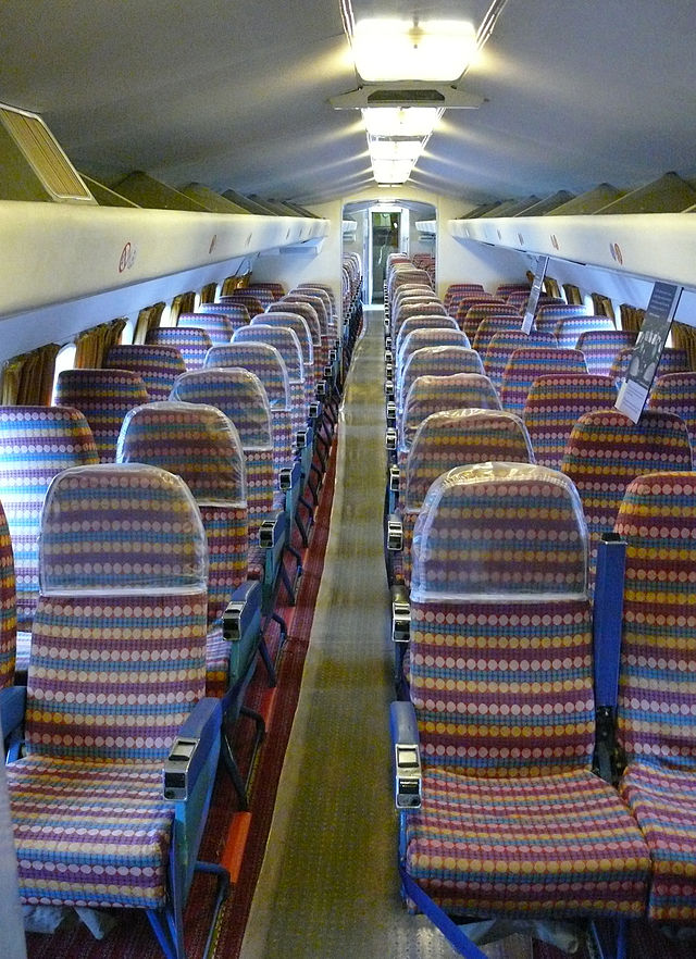
The decor in 1962 inside the rest stop restaurant was very similar to this.
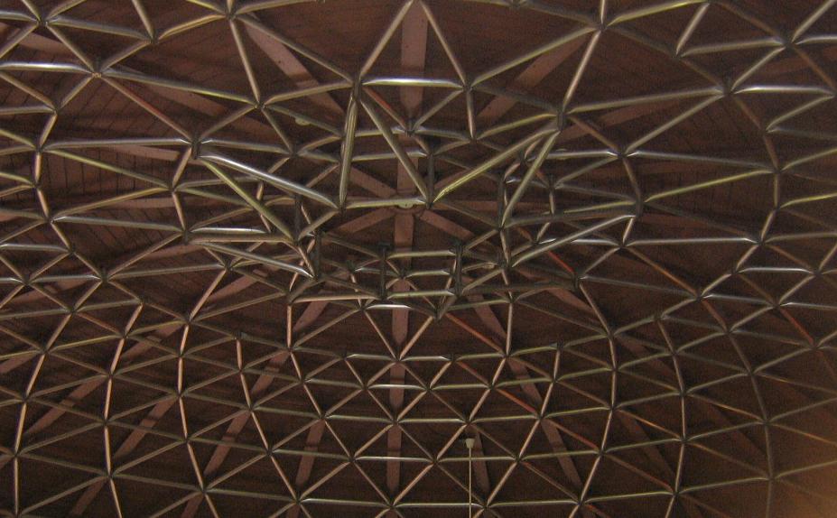
Detail of the exposed geodesic dome Kohl used for the rest stop roof. (photo: Alan McLeod)
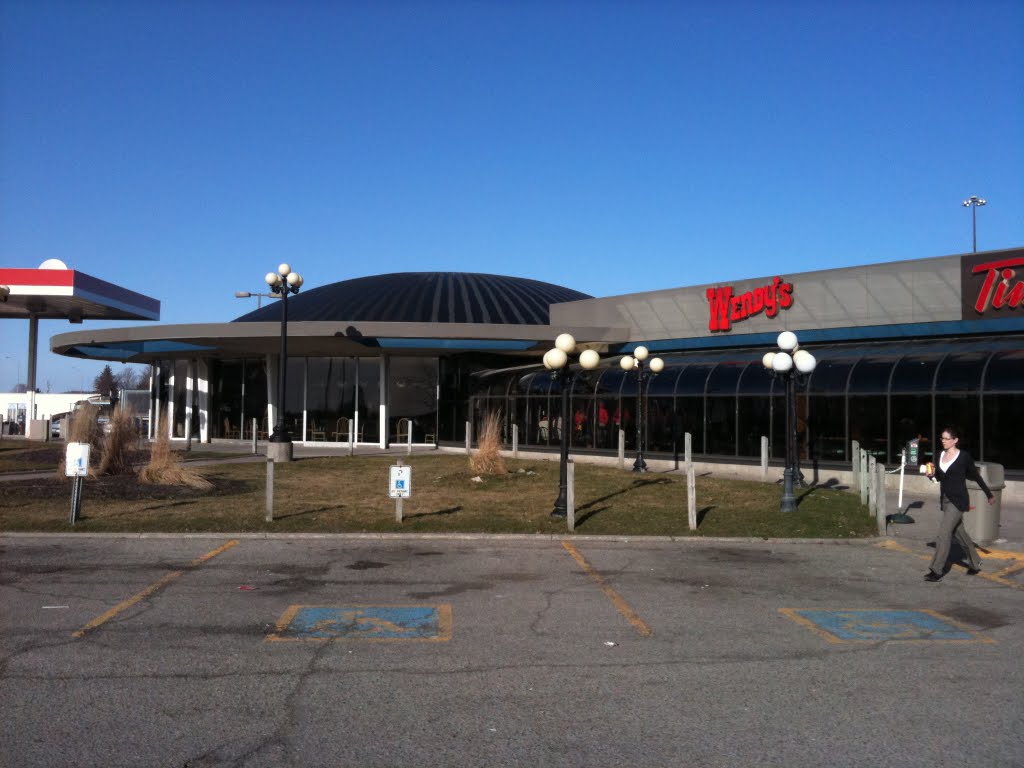
I remember vividly pulling up to Kohl’s domed masterpieces as a kid in the back of the car and being in awe of the futuristic space age design and its fascinating exposed geodesic dome above the restaurant as I ate my Jello and greasy burger. As a I grew up and moved to Ottawa, I still stopped into these domed stations on my way home or on road trips, but they evolved over time and were drastically altered to try and keep up with current, more modern design trends. The original spires were removed, the dome was painted brown, the covered breezeway from the gas station removed, and the independent restaurants were replaced with typical fast food chains.
Drastically altered and with fast food chain restaurants, this 2009 photo of the Kohl rest stop looks nothing like its original 1962 incarnation. (photo: Google Streetview)
Location of now demolished Kohl 401 rest stop in Odessa, On.
Eventually, the Kohl stations slowly began to be demolished in the early 2000’s to make way for new “On Route” stations, until all of them eventually disappeared. Google Streetviews still show the Kohl rest stops from their 2009 streetview photo collection, which is possibly the only remaining record of these Ontario icons. None remain, all traces of them wiped off the 401. They will remain for me a valuable part of my childhood memories and continue to be a rest stop in my mind when I daydream of days gone by.
NOTE: This article originally appeared in the Ottawa Citizen, Friday October 10. Click here to see the complete original article.
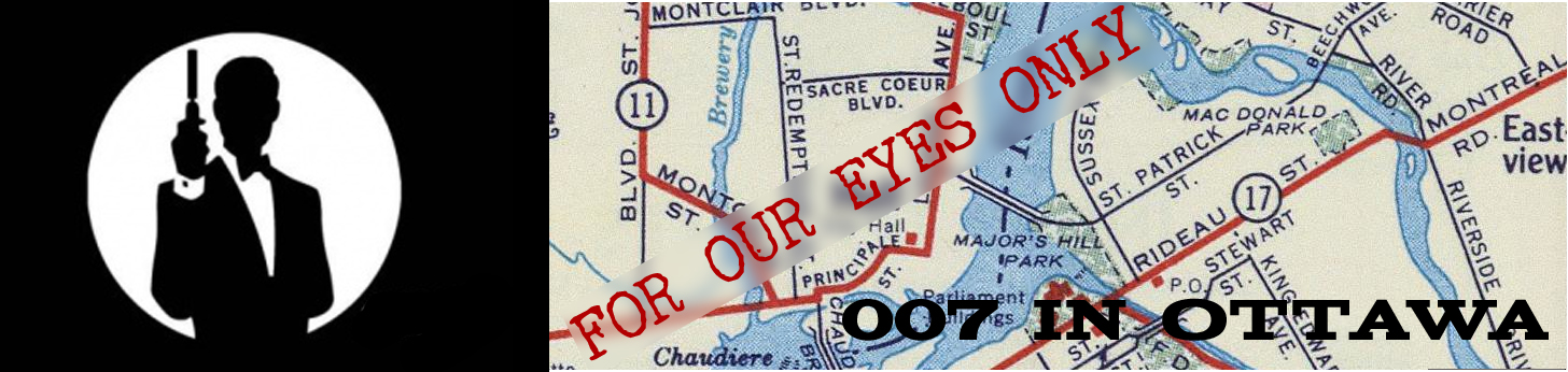
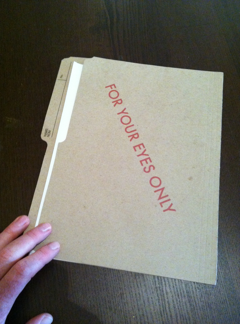
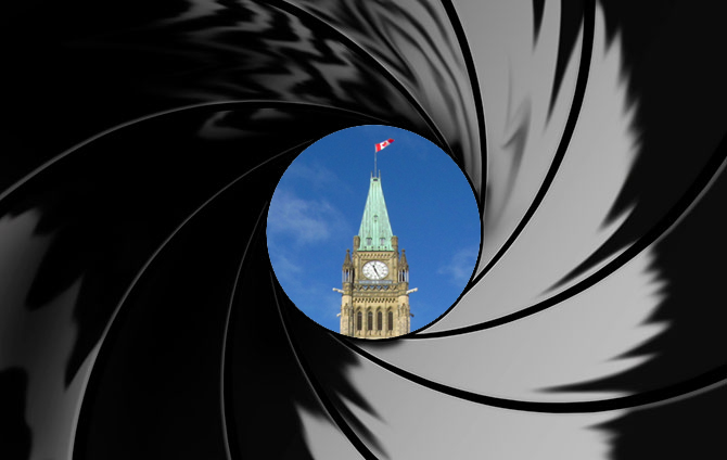
In 1960 author Ian Fleming published his eighth novel featuring the fictional British Secret Service agent, James Bond. The novel was called For Your Eyes Only and it was a collection of five short stories based on script outlines he had created for a failed CBS Bond television series. For Your Eyes Only later became the basis of the 1981 film of the same name starring Roger Moore, but like many of Fleming’s Bond novels, there is little reference to the original story in the film adaptation and For Your Eyes Only is no exception since most of the original novel takes place right here in Ottawa.
The original book version uses locations in Canada and Vermont, most notably in Ottawa as he prepares for a mission to execute an ex-World War 2 Gestapo agent, Von Hammerstein, of whom Fleming based on the actual General Baron Kurt Von Hammerstein-Equord of Hitler’s Third Reich.
Fleming characteristically writes his Bond novels in great detail, using his own experiences as a British operative during the Second World War to give his stories an element of realism. In For your Eyes Only, Bond’s exploits throughout Ottawa and Quebec are thus carefully outlined in researched detail by Fleming which allows us to re-trace Bond’s mission exactly as it would have happened in the Nation’s Capital in 1959 by visiting the very same places as they exist today.
Follow Bond as we recreate his mission in Ottawa through images referenced to the original Ian Fleming story, For Your Eyes Only.
BOND IN OTTAWA
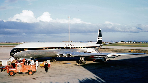
Bond’s mission to Canada begins in London when he boards a new 1959 “Jetliner” BOAC DeHavilland Comet, of which he dislikes because it is less relaxing than the old prop planes.
Bond’s Comet lands in Montreal since Ottawa’s Uplands airport would not be open to jetliner traffic until the following year, 1960.
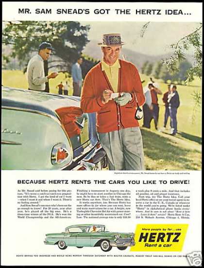
Commander James Bond has to rent a car for the two hour drive to Ottawa. He does so from Hertz Car Rental at the Montreal Airport. This is an authentic 1959 Hertz car rental ad.
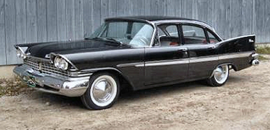
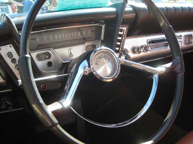
Bond rents a 1959 Plymouth 4 door sedan for his drive to Ottawa.
Behind the wheel of his rented Plymouth, Bond drives out of Montreal and onto Highway 17 to Ottawa. The 417 did not exist in 1959.
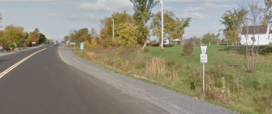
Bond remarks on the “broad highway 17 to Ottawa”. This is a section of the old highway 17 Bond wouid have travelled on.
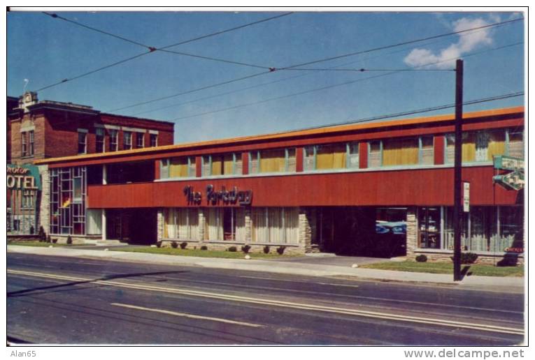
It is not mentioned in the novel, but Fleming often puts Bond in motels when he travels within North America. Entering Ottawa, Bond most likely would have checked into “The Parkway” motel on Montreal Road (Hwy17) that was popular in the 1950s.
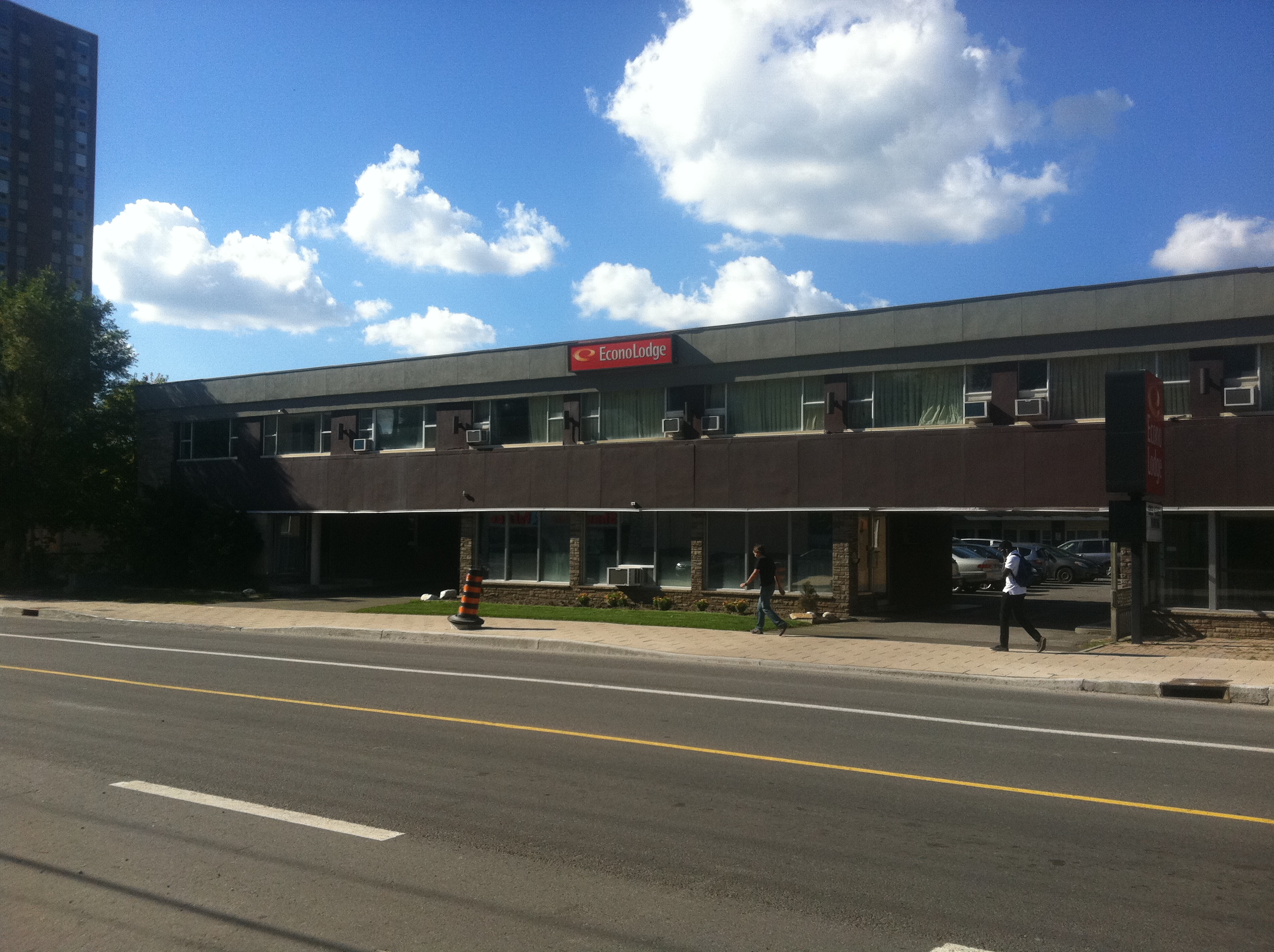
The Parkway Motel still exists, but is drastically altered from its original 1959 appearance. It is now an Econolodge.
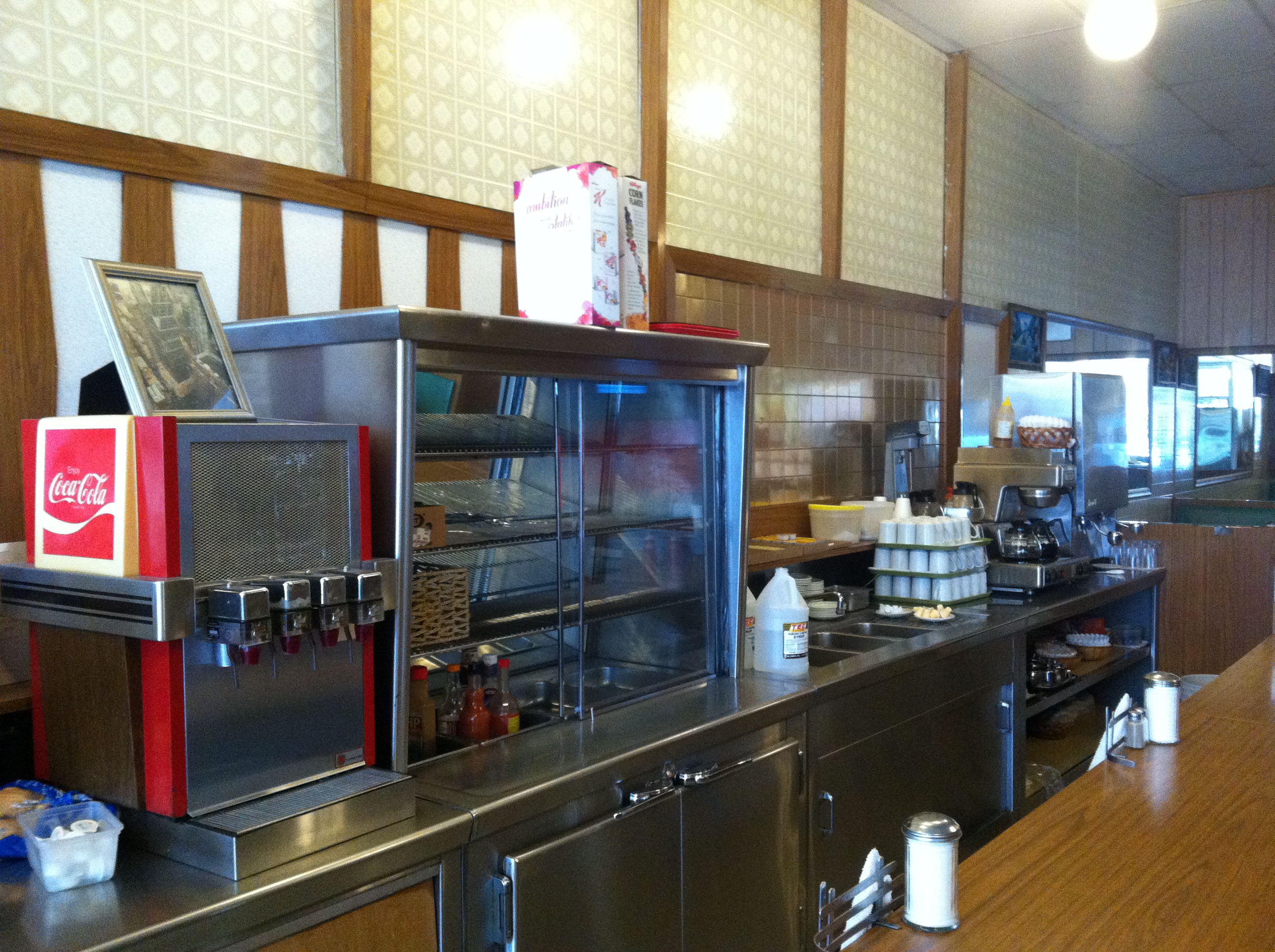
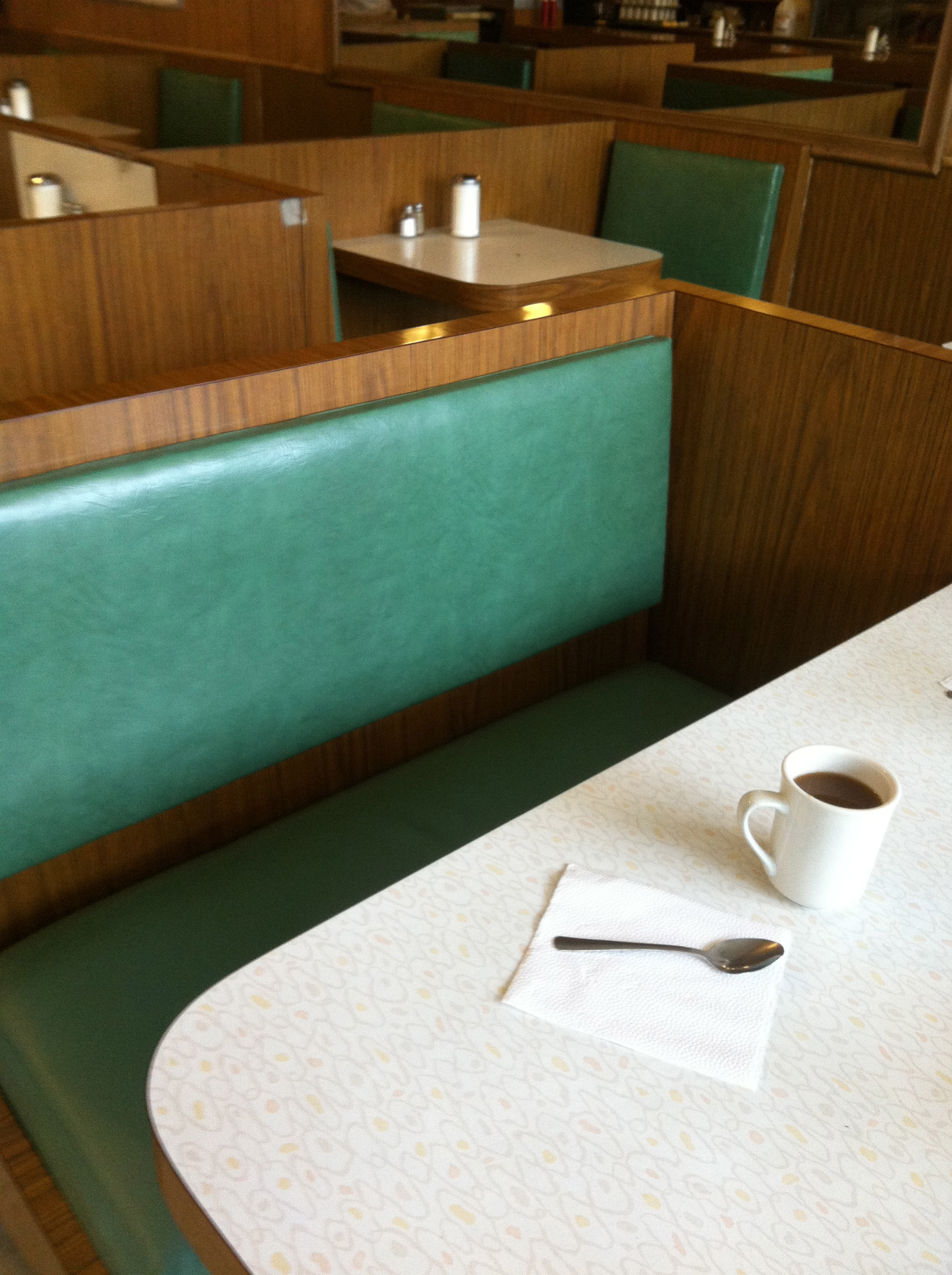
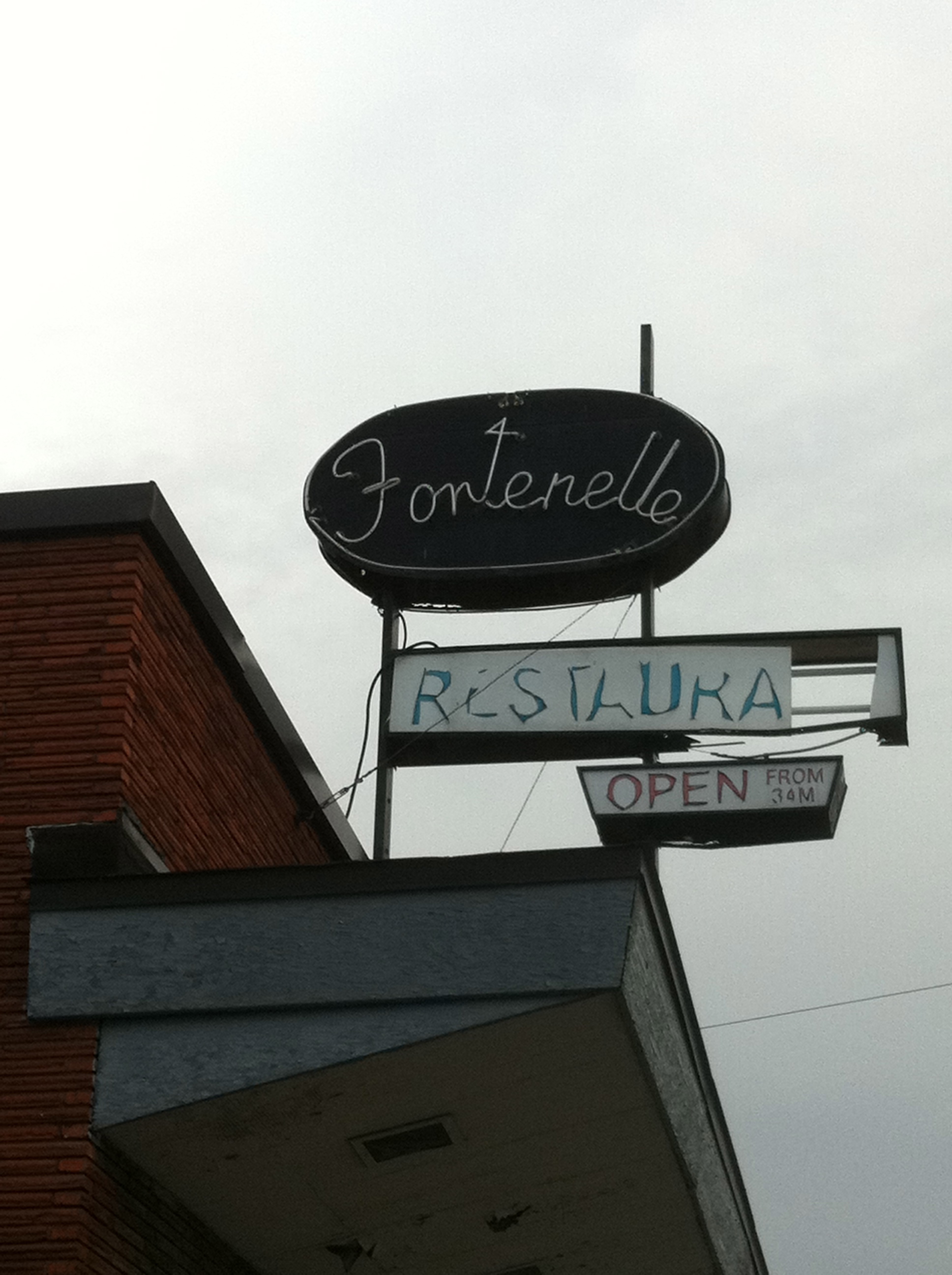
After a restful sleep at The Parkway Motel, Bond probably went down Montreal Rd. and grabbed breakfast at the nearby restaurant, The Fontenelle, originally built in 1949, which is still there today.
The Fontenelle is truly a time capsule restaurant, with original booths and decor. Bond would have slipped in for a quick meal here before his meeting at RCMP HQ downtown.
Bond most likely enjoyed a coffee before his mission briefing downtown.
The original Fontenelle sign as it appears today.
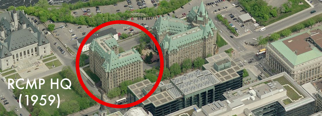
Bond then had to meet with the RCMP Commissioner at their headquarters, which in 1959, was a building across from the Parliament Buildings.
“The Headquarters of the Royal Canadian Mounted Police are in the Department of Justice alongside Parliament Buildings in Ottawa. Like most Canadian public buildings, the Department of Justice is a massive block of grey masonry built to look stodgily important and to withstand the long and hard winters.” -Bond
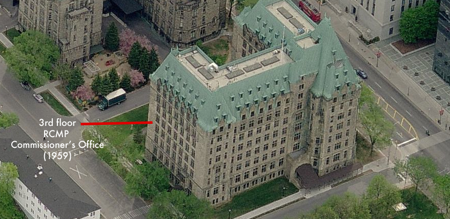
“Bond had been told to ask at the front desk for the Commissioner and to give his name as ‘Mr James’. He did so, and a young fresh-faced RCMP corporal, who looked as if he did not like being kept indoors on a warm sunny day, took him up in the lift to the third floor…” – FLEMING
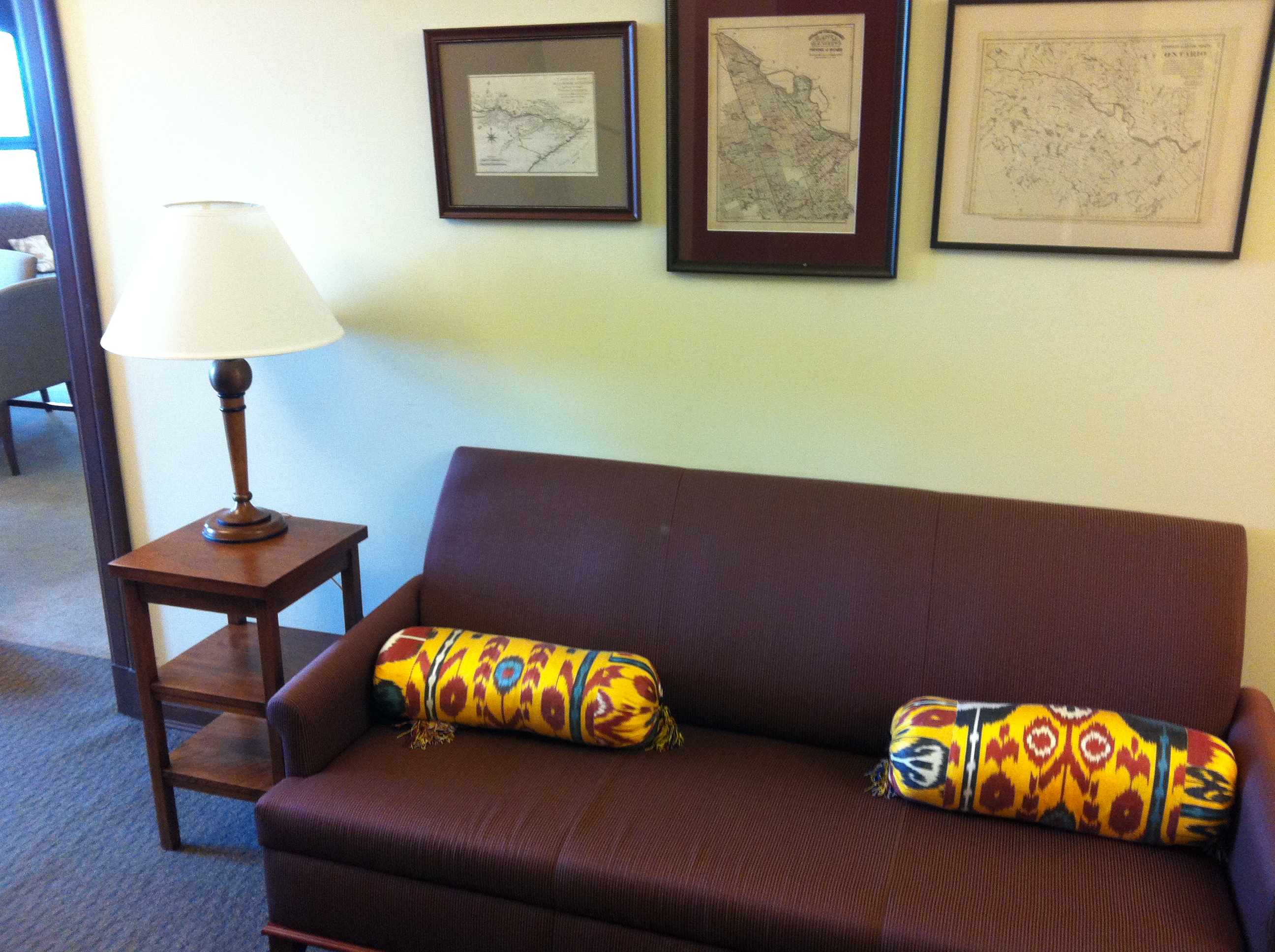
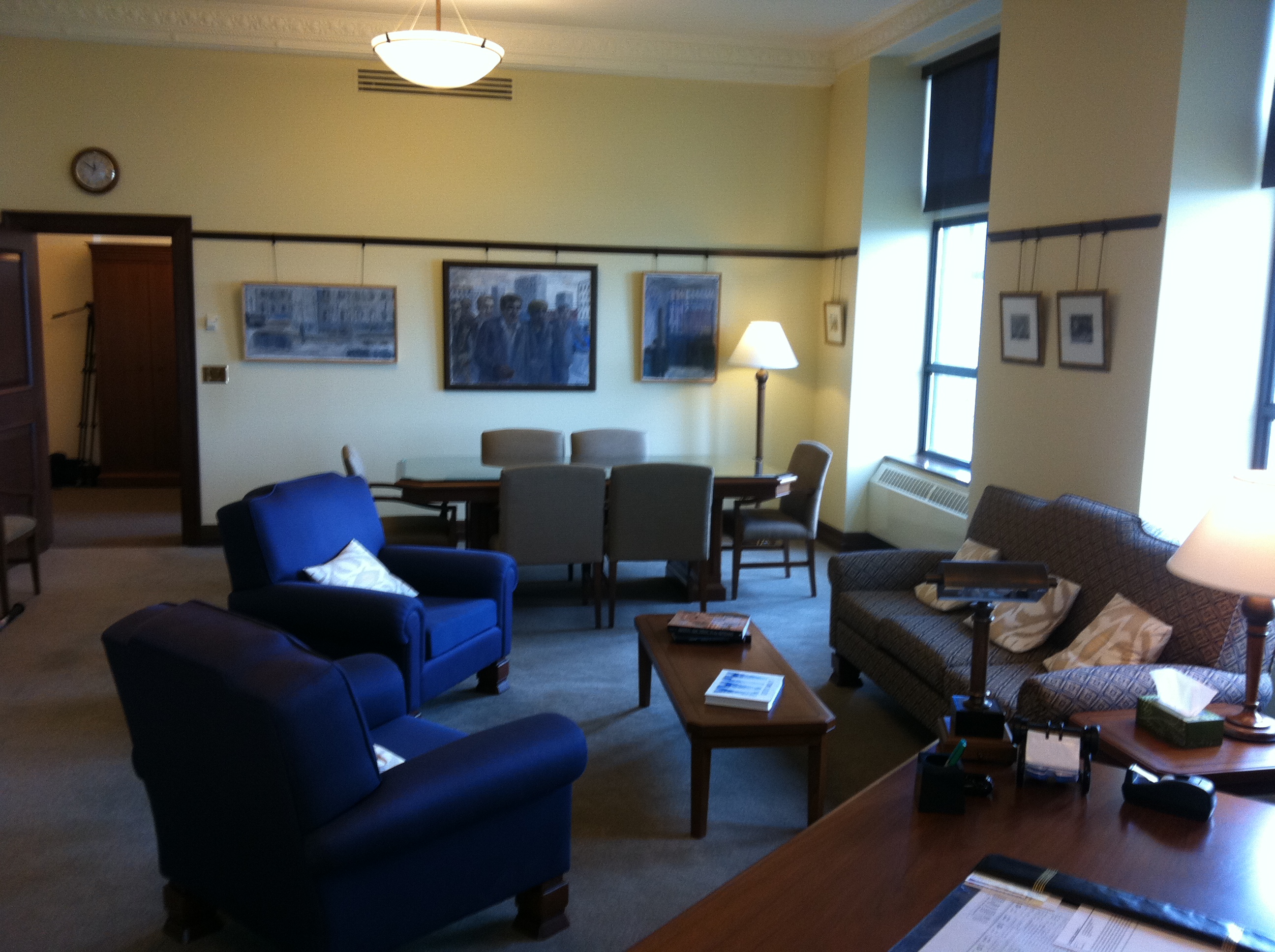
Through special permission, I was able to visit the old RCMP Commissioner’s office, which has since been converted into an MP office . This is the waiting room Bond would have sat in before his meeting..Fleming describes it as “a large tidy office which contained two girl secretaries and a lot of heavy furniture. The sergeant spoke on an intercom and there was a ten minutes’ delay during which Bond smoked and read a recruiting pamphlet..”
“When he was shown in through the connecting door a tall youngish man in a dark blue suit, white shirt and black tie turned away from the window and came towards him.”
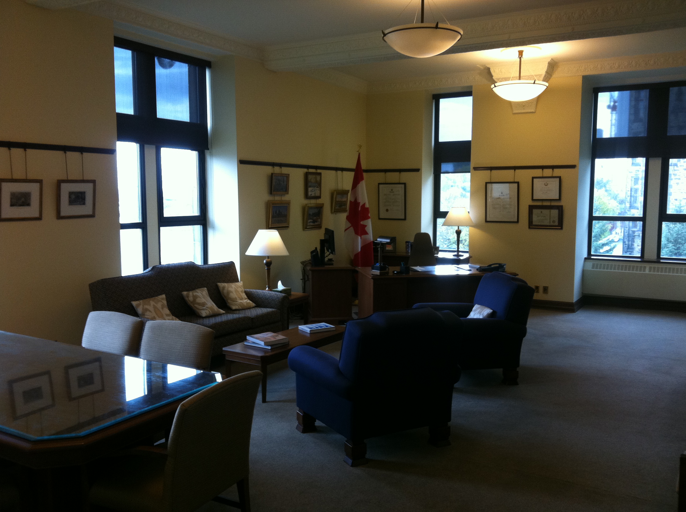
This is the old RCMP Commissiner’s office as it looks today where Fleming described Bond being briefed on his mission to execute Von Hammerstein.
“Colonel Johns opened a drawer in the desk and took out a bulging file and opened it.”
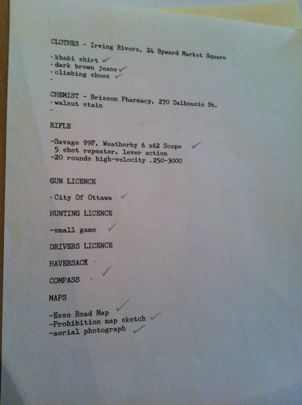
“The top document was a list. He put his pencil on the first item and looked across at Bond. He ran his eye over Bond’s old black and white hound’s-tooth tweed suit and white shirt and thin black tie. He said: “Clothes.” He unclipped a plain sheet paper from the file and slid it across the desk. “This is a list of what I reckon you’ll need and the address of a big second-hand clothing store here in the city. “
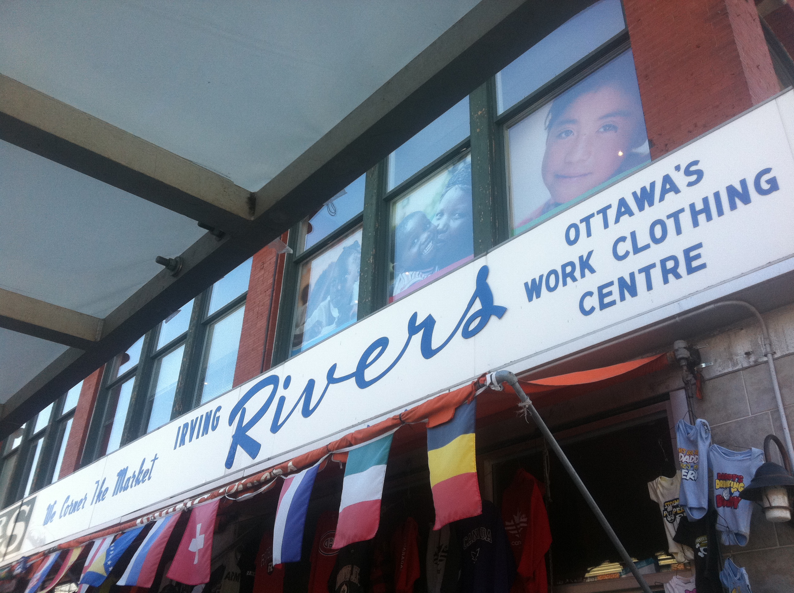
in 1959, the used clothing/surplus store Bond would get his mission clothing items was most likely Irving Rivers, which opened in 1950 and was just down the street from the RCMP HQ.
“…khaki shirt, dark brown jeans, good climbing boots or shoes. See they’re comfortable.”
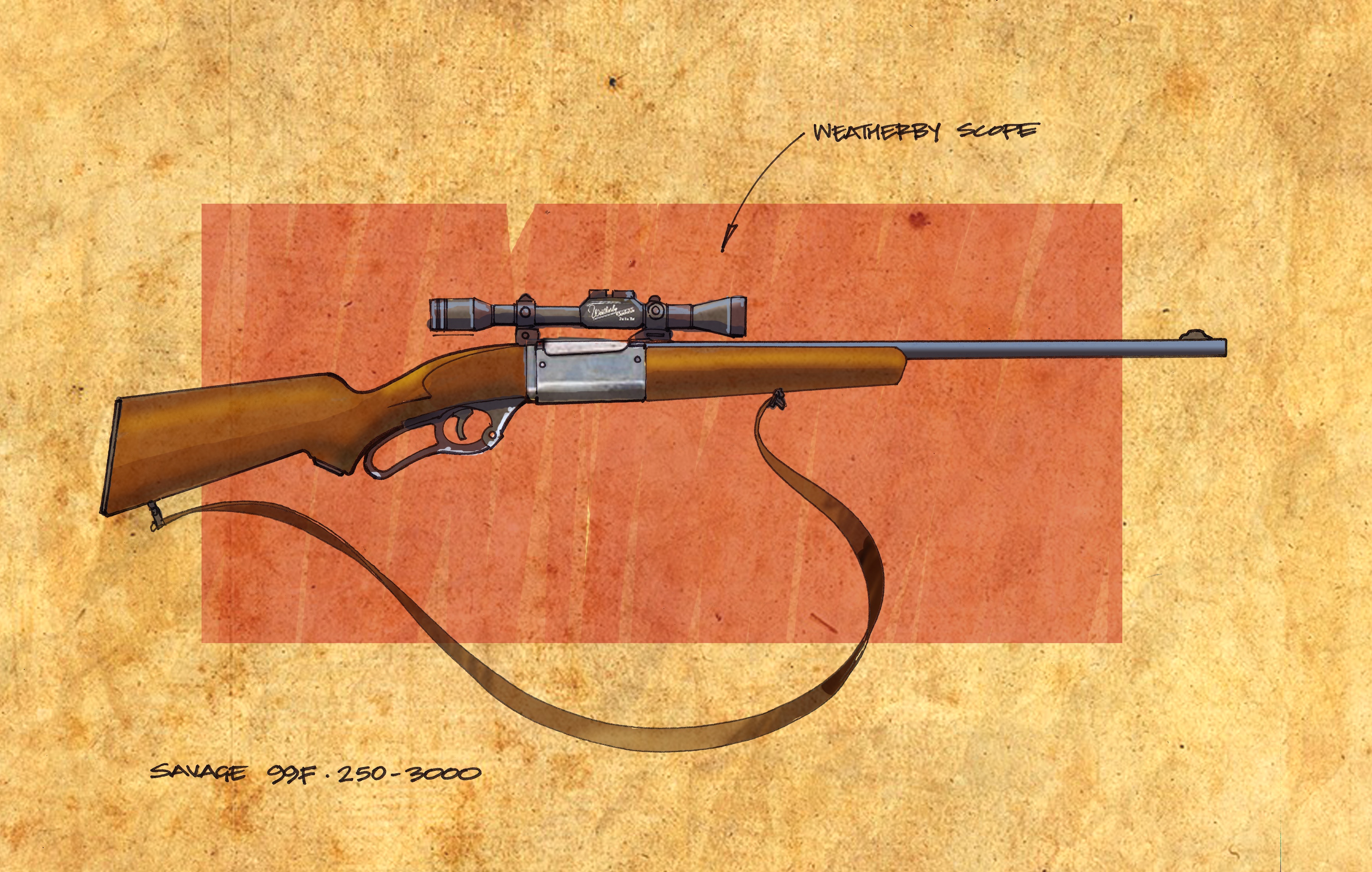
“Rifle. Went down myself and put it in the boot of your Plymouth while you were waiting. One of the new Savage 99Fs, Weatherby 6 x 62 ‘scope, five-shot repeater with twenty rounds of high-velocity .250-3000.”
“Now then, maps. Here’s a local Esso map that’s all you need to get you to the area.” -This is an actual 1959 Esso roadmap that Bond would have used.
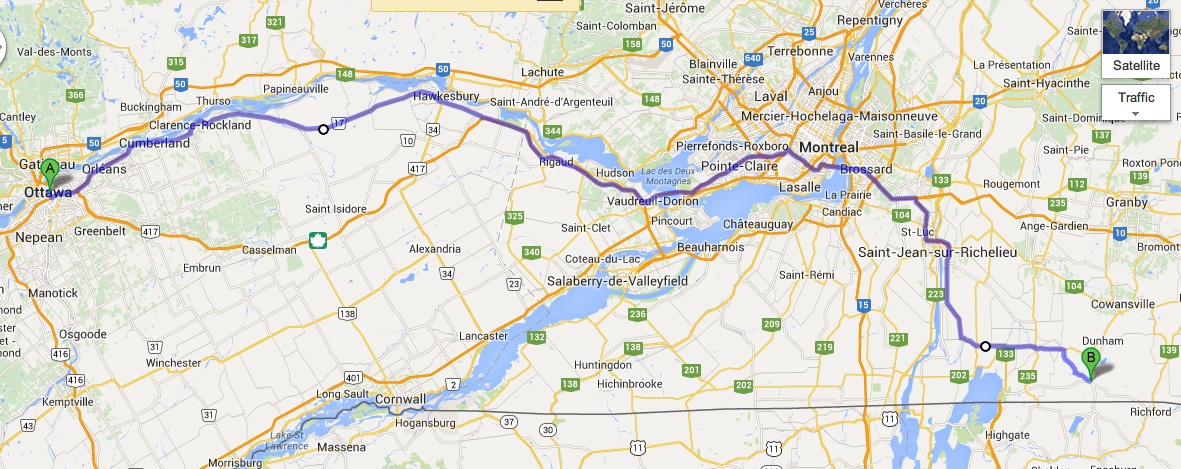
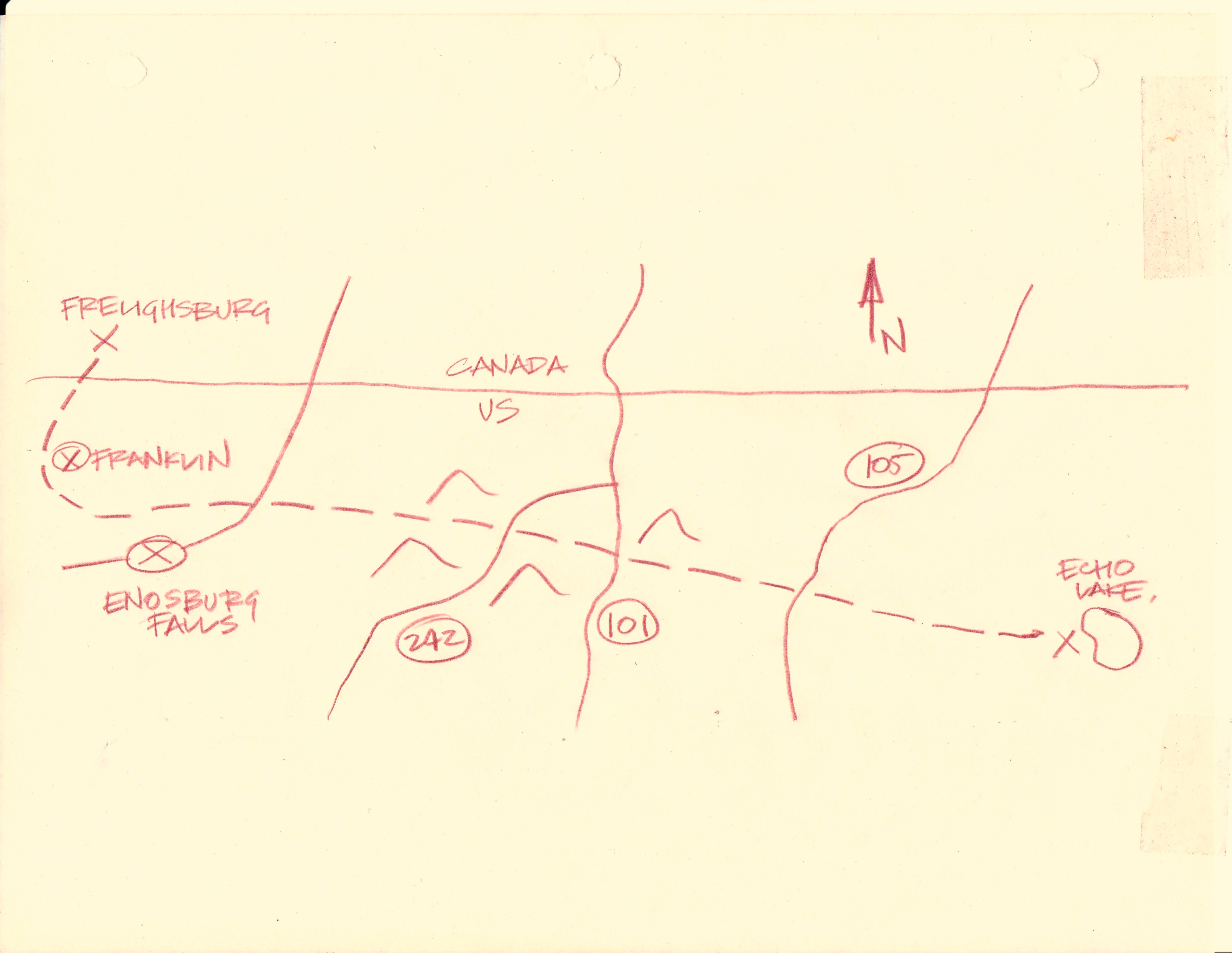
“You take this route 17 back to Montreal, get on to 37 over the bridge at St Anne’s and then over the river again on to 7. Follow 7 on down to Pike River. Get on 52 at Stanbridge. Turn right in Stanbridge for Frelighsburg and leave the car in a garage there.” – Google map of the exact same route accurately described by Fleming.
Sketched map of Prohibition smuggling path across from Canada into the United States. “Colonel Johns went back to his chair and took two more pieces of paper off the file. The first was a scrap of pencilled map, the other a section of aerial photograph. “
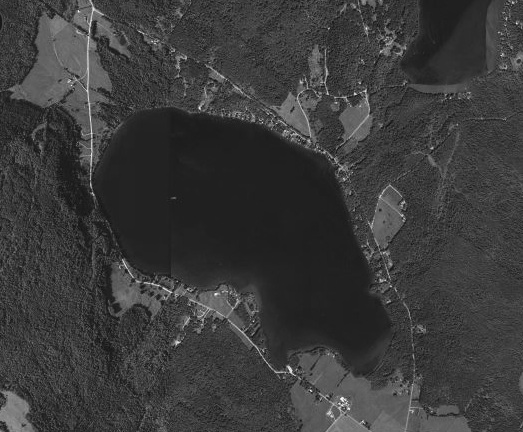
Echo Lake that Fleming refers to in For Your Eyes Only actually does exist, right where he says it is in Vermont. Here is a current Google aerial image of it.
“He passed the day looking to his equipment and wearing in the soft ripple rubber climbing boots he had bought in Ottawa. He bought glucose tablets and some smoked ham and bread from which he made himself sandwiches. He also bought a large aluminium flask and filled this with three-quarters Bourbon and a quarter coffee.” -Fleming
Bond then leaves Ottawa and drives to Frelighsburg, QC. There he parks his car at a gas station. This is the gas station in Frelighsburgh as shown on Google streetview where Bond probably parked his rented Plymouth before heading to Echo Lake.
Bond then completes his mission of killing Von Hammerstein at Echo Lake with the supplies and information he got in Ottawa. With his mission complete, he returns to Canada.
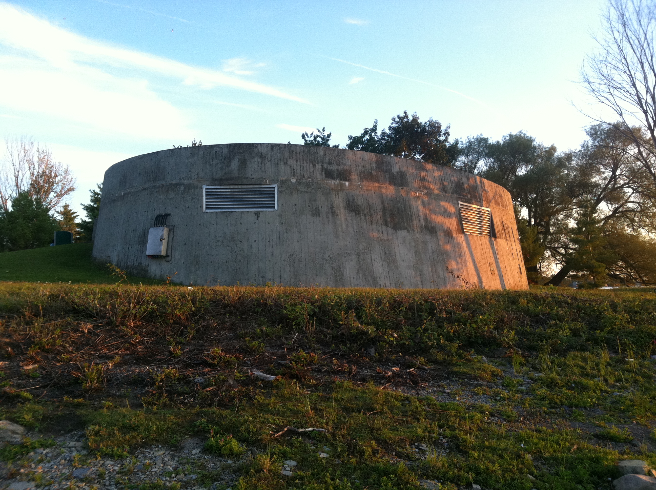
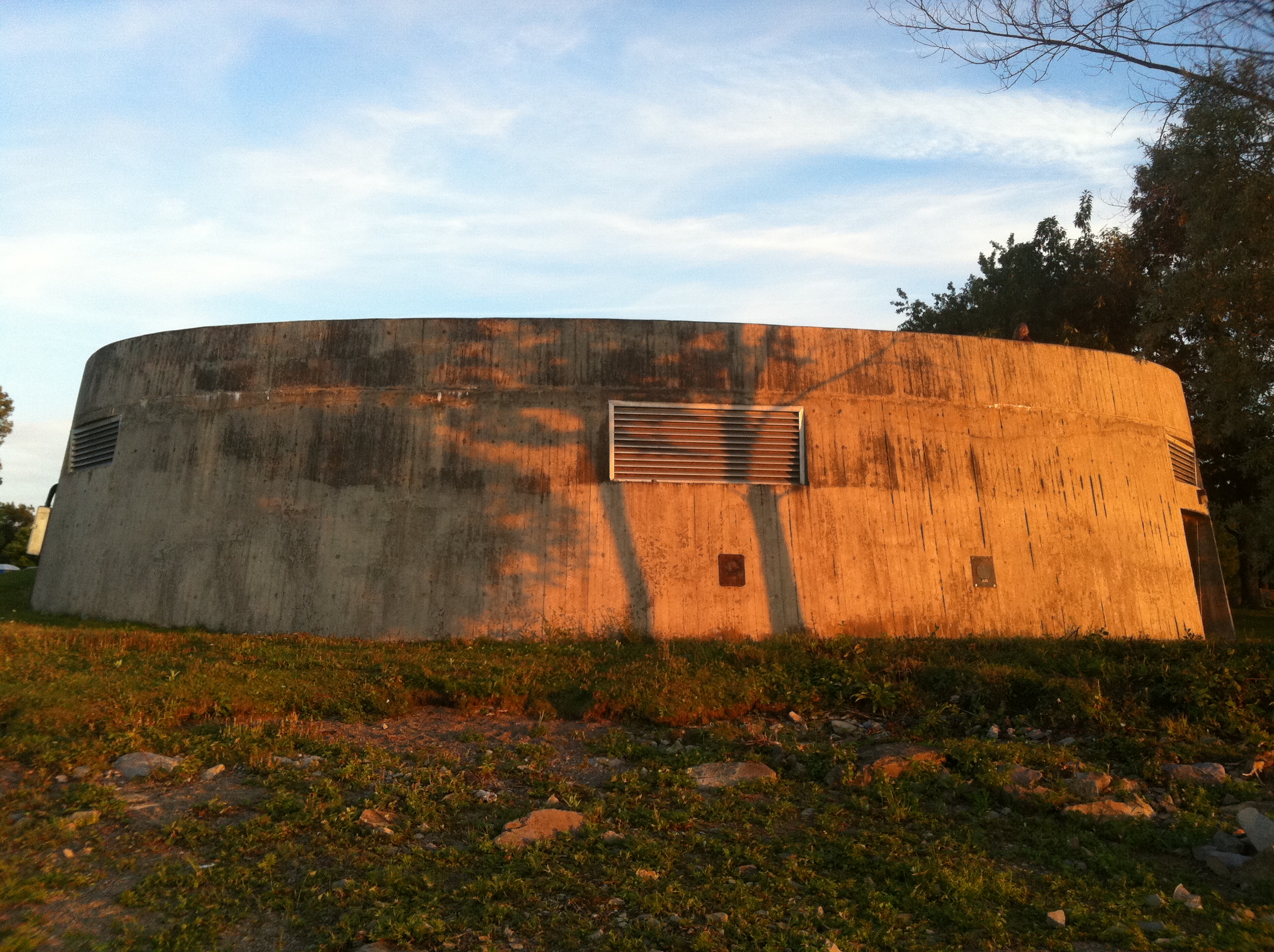
The mysterious concrete bunker at Remic Rapids has perplexed many a passerby.
A familiar sight to many Ottawa residents enjoying the river-front path along the Ottawa River, the concrete bunker at Remic Rapids has been a mystery to many, myself included. Having lived nearby for over 20 years, I have always been curious as to what purpose this odd concrete structure had situated on the picturesque shoreline of the Ottawa River.
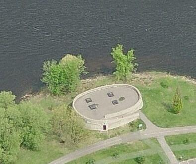
Aerial view of the concrete structure at Remic Rapids.
Once and for all I thought I’d get to the bottom of what this architectural oddity was, and find out what purpose it had, or still has. What was revealed was a fascinating hidden history that includes the fact that Ottawa once had a NUCLEAR REACTOR.
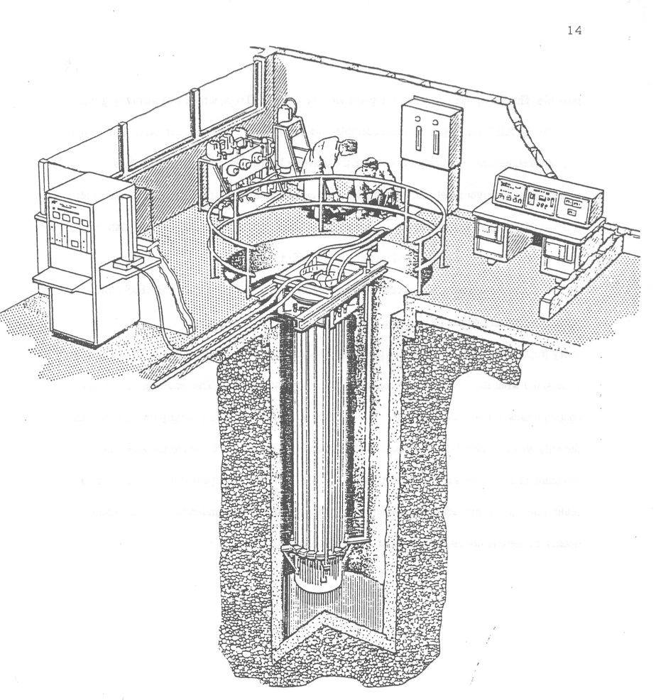
The year was 1970 and the Atomic Energy Canada Limited, or AECL, was placing a SLOWPOKE-2 class nuclear reactor at Tunney’s Pasture. According to The Canadian Society For Mechanical Engineers documents, this nuclear reactor was installed in Tunney’s Pasture at 20 Goldenrod Avenue. It was constructed as a commercial testing reactor to determine its feasibility. This nuclear reactor was in full operation after it reached critical mass in 1971 until 1984 when it was then moved to another test site located in Kanata, later decommissioned in 1992.
Sketch from The Canadian Society For Mechanical Engineers document of what the Tunney’s Pasture nuclear reactor looked like.
The reactor, nicknamed SLOWPOKE, (an acronym for Safe LOW-POwer Kritical Experiment) which used 93% enriched uranium. The reactor core sits in a pool of regular light-water, 2.5 m diameter by 18 feet deep, which provided cooling. The reactor built at Tunney’s Pasture achieved “Critical Mass” or the point at which a nuclear reaction is self-sustaining on May 1 1971 and continued operating until 1984.
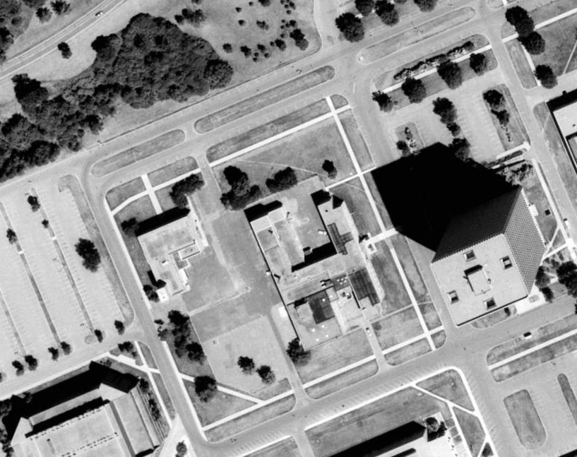
Atomic Energy of Canada Limited Buildings located on the Tunney’s Pature Complex that housed the SLOWPOKE nuclear reactor 1971-84.
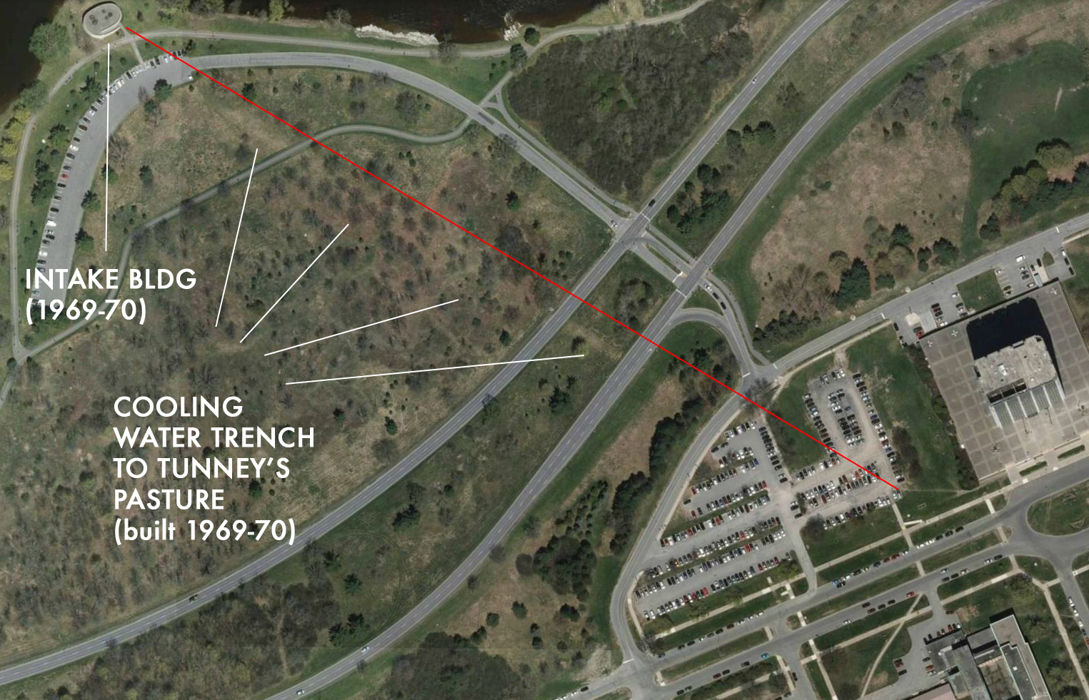
The concrete bunker that remains on the shore of the Ottawa River directly opposite the old nuclear reactor site was built at the same time as the reactor in 1969-70. It was built to facilitate the increased “cooling” needs of Tunney’s Pasture, one of them you could speculate being the addition of a small nuclear reactor.
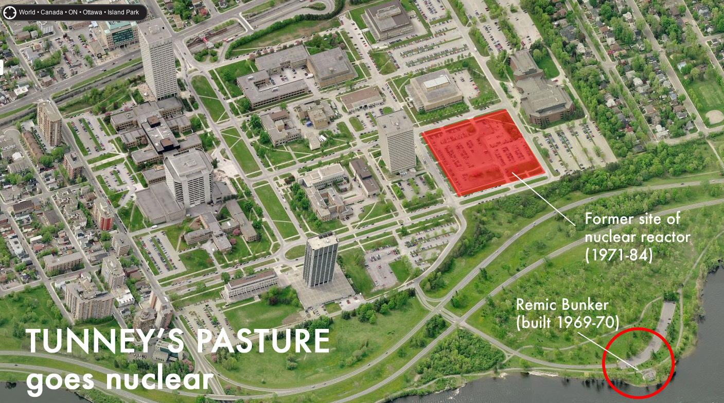
Aerial image showing the proximity of the Remic Bunker to the Tunney’s Pasture Nuclear Reactor site.
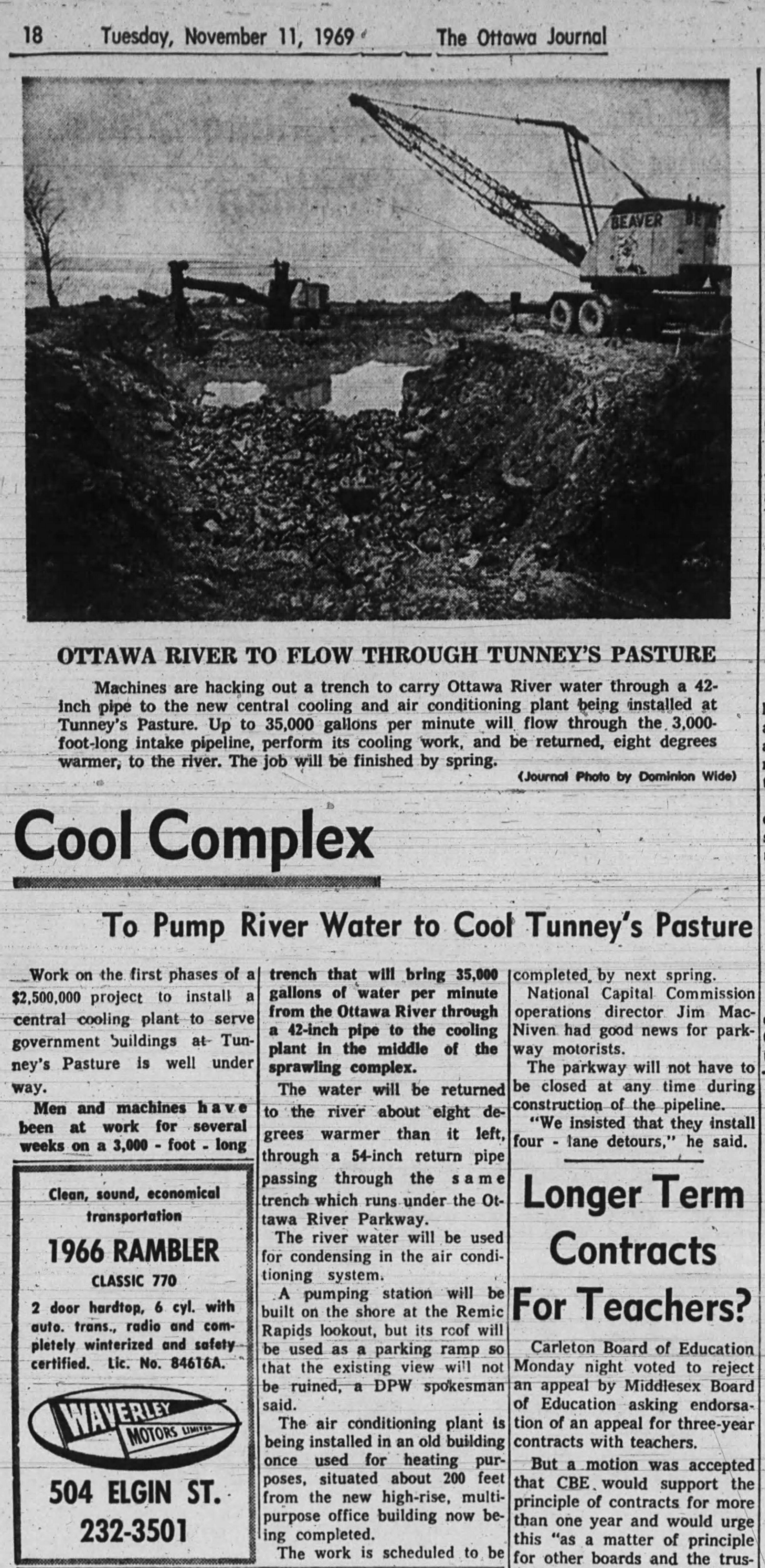
A 1969 November 11 Ottawa Journal article describes in detail the construction of the bunker and a trench used to contain a pipeline to provide this cooling water to Tunney’s Pasture. A 3,000 foot long pipeline was placed in an underground trench that ran from the Ottawa River bunker building to Tunney’s Pasture to provide, as the article states: “river water which will be used for condensing in the air conditioning system.”
The concrete bunker built in 1970, just before the nuclear reactor began operation, housed a pumping station that provided a 35,000 gallons per minute water intake from the Ottawa River through a 42 inch diameter pipe underneath the Parkway over to Tunney’s Pasture. A current satellite image of the area clearly shows the trench line from the bunker to Tunney’s Pasture.
The pipeline would then return used water back to the Ottawa River at a temperature 8 degrees warmer. The pumping station concrete structure and the pipeline was built at a cost of $2.5million and was constructed in co-operation with the NCC who owned the land the project was built on. The NCC at the time re-assured Ottawa motorists the construction of the bunker and pipeline would not disrupt traffic as it crossed the Parkway saying “We Insisted that they install four lane detours,”
Four years after they were completed in 1976, the Remic Bunker and Nuclear Reactor site.
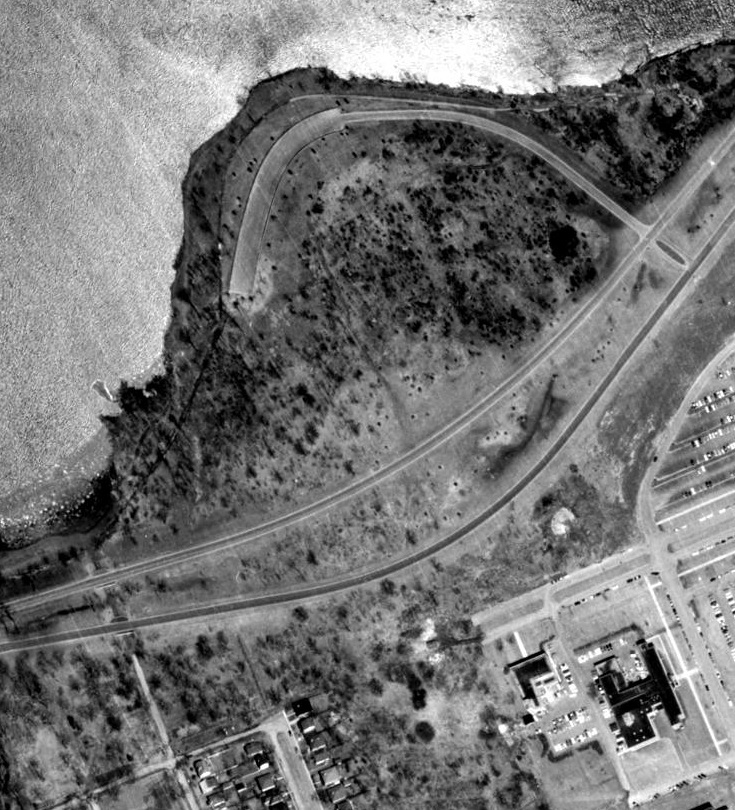
A 1965 aerial image showing the Atomic Energy Canada Buildings at Tunney’s Pasture and the area of land where the bunker and cooling water pipeline have yet to be built.
The pumping station bunker and pipeline were finished in 1970 and the reactor began operating a year later. Whether or not the bunker pipeline bringing cooling water to Tunney’s Pasture was directly related to the addition of a nuclear reactor remains speculation but it is interesting to note the proximity and similar timeline of both projects.
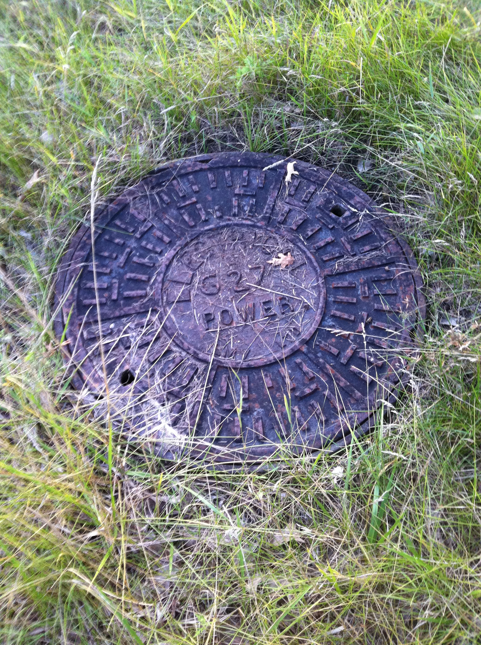
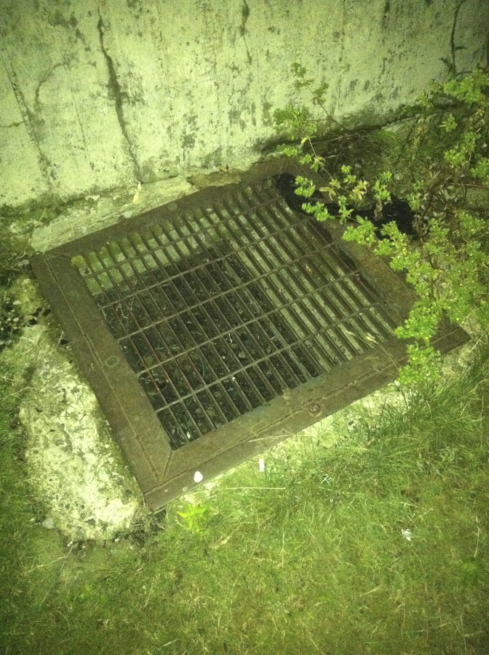
One of the access hatches in the field along the 1970 pipeline from the bunker to Tunney’s Pasture.
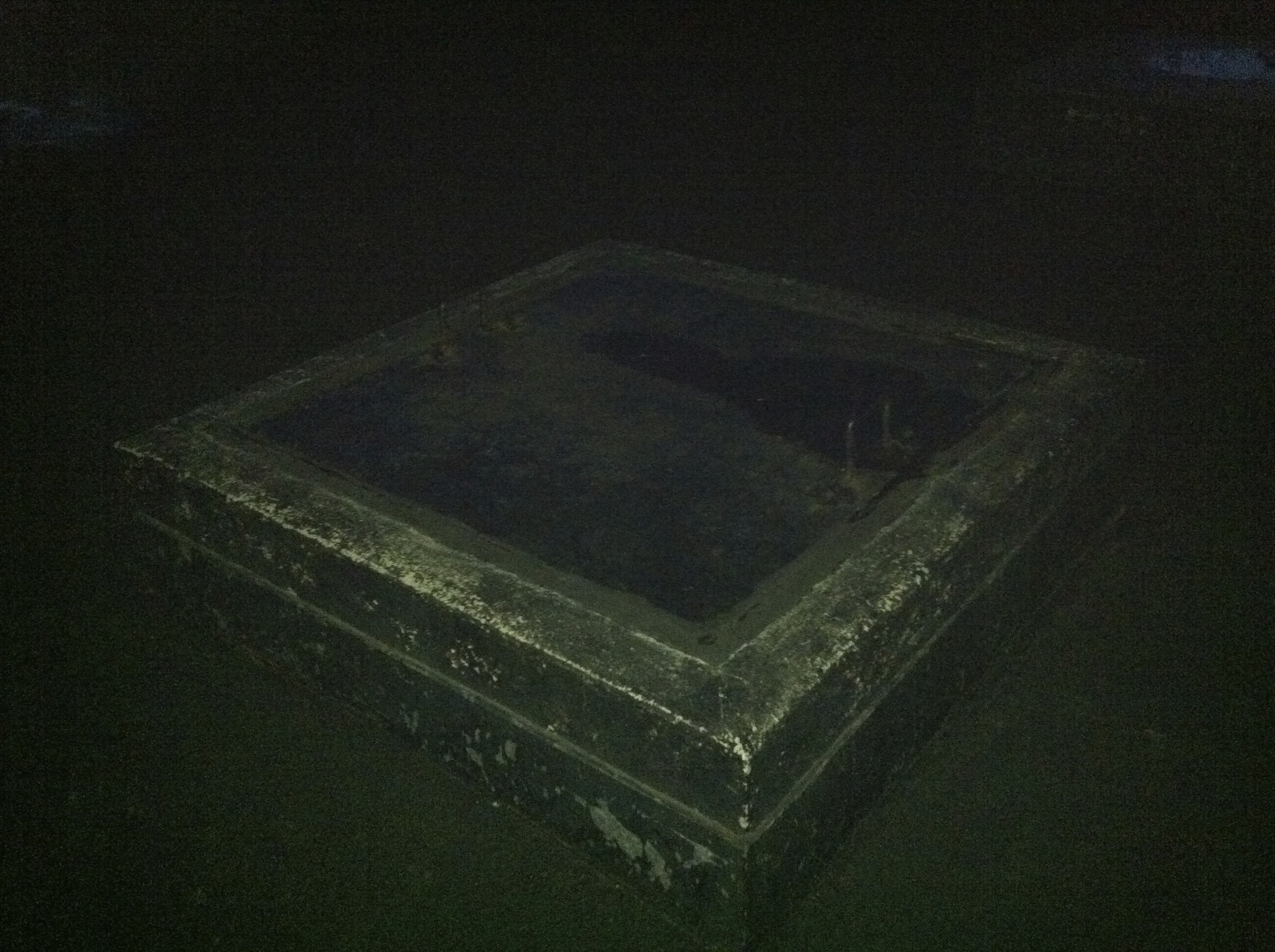
One of four hatches on the roof of the bunker.
This ground level vent spews a lot of hot air.
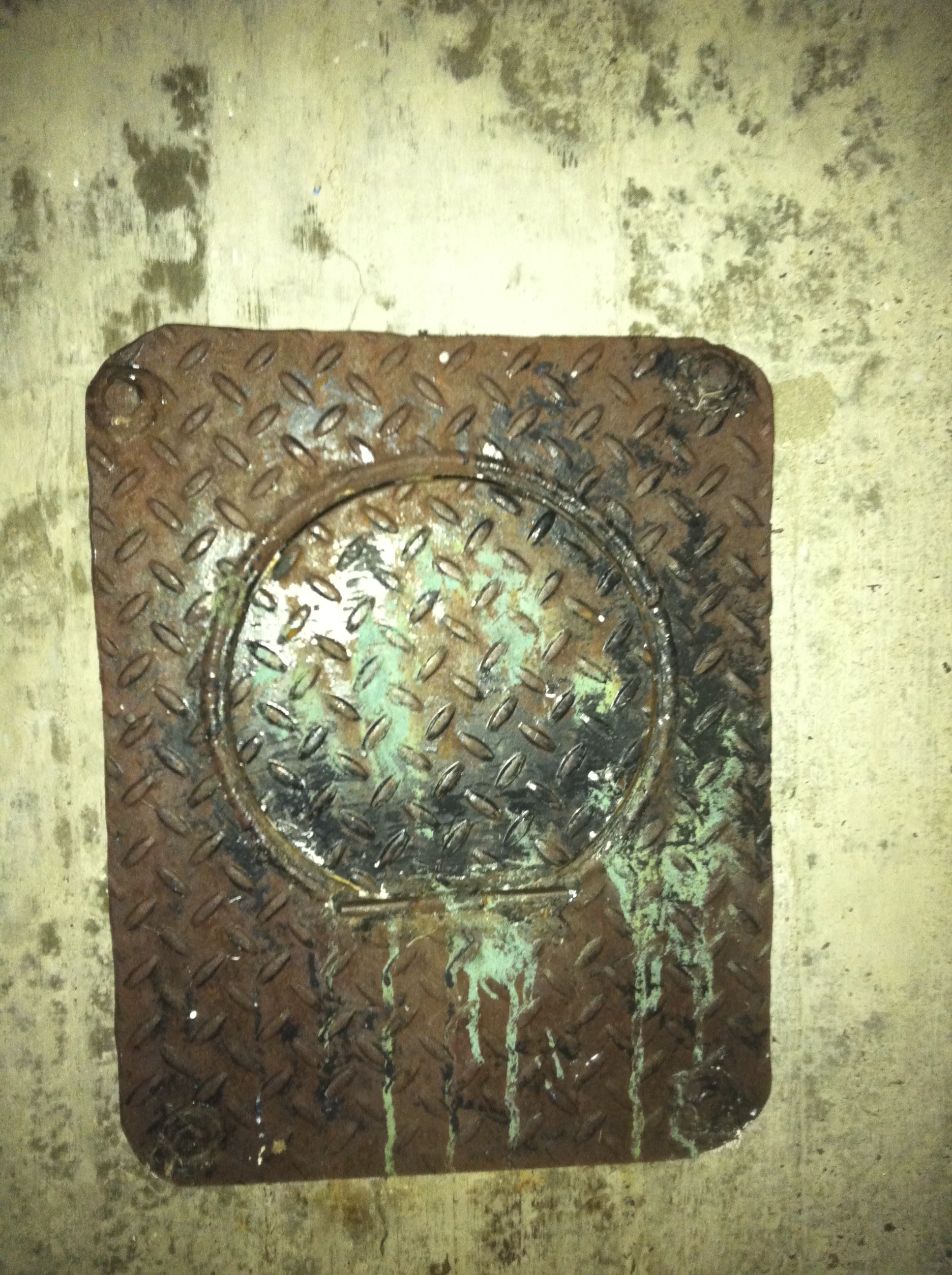
One of the many odd hatches on the bunker.
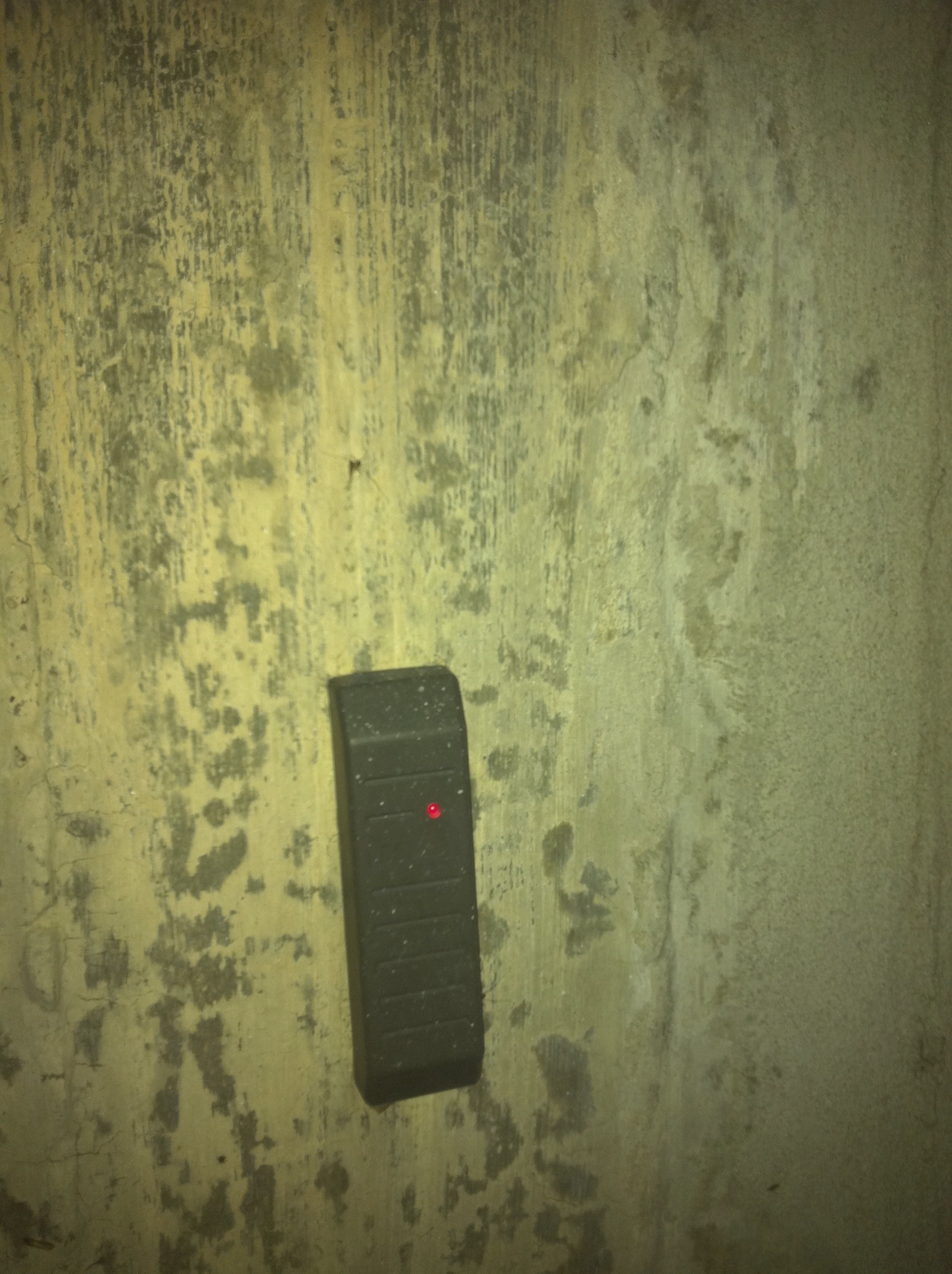
Built in 1970, the bunker has been updated with modern security features.
The SLOWPOKE reactor was shut down in 1984 and the building it was housed in has since been demolished and is now a parking lot. However, the bunker at Remic Rapids is still there, and you crawl on top of its roof and listen to the hum of machinery working away below almost 45 years later, still bringing cooling waters from the Ottawa River through a 3,000 foot pipeline over to cool the hot air being generated at Tunney’s Pasture.
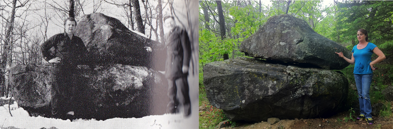
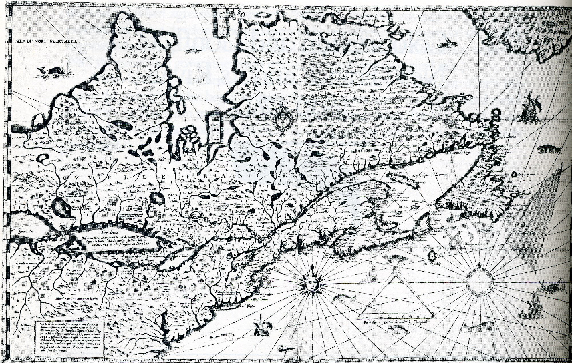
In 1953 two men discovered a large rock near Renfrew inscribed with an apparently 400 year old message from Samuel deChamplain. We found the rock this summer and studied it more closely…
Over 400 years ago the famous explorer and geographer Samuel de Champlain mapped out a course through the uncharted territory of the Ottawa Valley in an effort to reach the Northern Sea. His journey up the Ottawa River in 1613 lead him through what is now Ottawa, the Chaudiere Falls, Lac Deschenes, Chats Falls and portaged lands beyond. Champlain’s quest up the Ottawa River took him as far as Pembroke where his journey ended and he turned back. This journey was documented by Champlain in his journal and later mapped out by him in 1632. This famous “Champlain Trail” was later substantiated when a French astrolabe, presumably Champlain’s, was found near Cobden in 1867, which is now on exhibit in the Canadian Museum Of History. Then in 1953 two men discovered a large glacial erratic stone on top of a hill near Renfrew with a large stone near its peak with an inscription carved into a flat side of the imposing rock. The carved letters spelled out “CHAMPLAIN JUIN 7 1613” .
The Champlain Stone and the two men who discovered it in 1953. (photo from “The UpperOttawa Valley” by Clyde C.Kennedy)
The stone was later deemed a hoax because 17th century French placed the number date ahead of the month, and used an “I” as the first letter of the month instead of a “j”. It was thus deemed a mysterious hoax, with no one ever confessing how or why they made it. The Champlain Stone was soon forgotten and it once again became lost in the deep woods from whence it was found. It is this mysterious stone of Champlain that I sought out to find once again, and examine it myself in more detail, hopefully shedding more light on this remarkable piece of Canadian folklore.
FINDING THE STONE
The stone was originally found in 1953 near Renfrew on top of hill located off the Ottawa River. Using a map from the excellent 1970 book “The Upper Ottawa Valley” by Clyde C. Kennedy from where I read about the Champlain Stone, I was able to overlay the 1970 map on a current map of the area to get a rough idea of where the stone was located.
Packing a rucksack and camera my girlfriend and I headed into the forest and began our climb through this terribly mosquito infested forest. Using the 1953 photograph of the Champlain Stone discovery, I had an idea of what it may look like, but was prepared for years of vegetation to conceal our prize. After about an hour of fruitless searching and 200 mosquito bites, I finally came across a rock that resembled the one in the 1953 photo. Holding the photo up to the rock, it was determined to be a match. We had found the mysterious Champlain Stone.
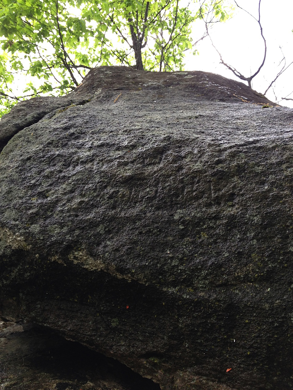
The inscription on the stone is obscured by lichen and is hardly legible.
An initial inspection of this large stone revealed a definite carved inscription on one of the flat sides of the glacial erratic. Covered in lichen, it was impossible to make out what exactly it said, but pouring a bottle of water over the rock inscription brought out the detail in the lettering more clearly which was then photographed and studied. Measurements were made and we returned back through the forest to our car.
ANALYSIS OF THE CHAMPLAIN STONE
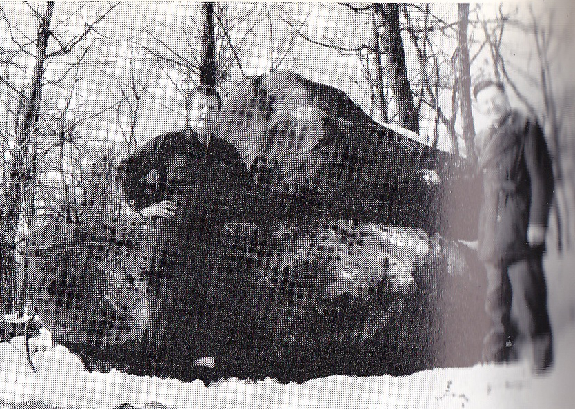
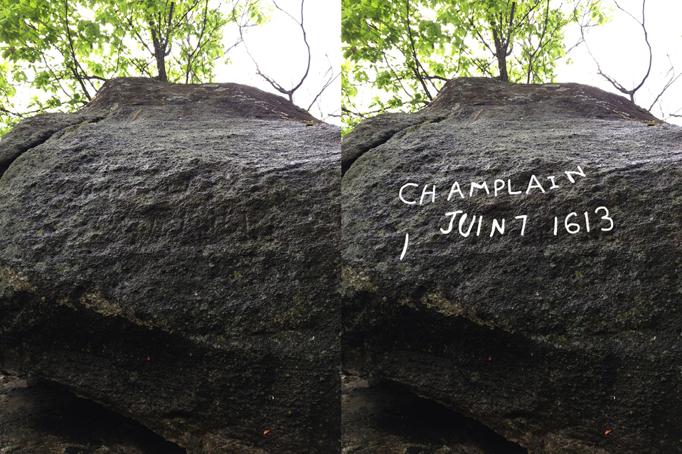
The Champlain Stone is an impressively large pair of boulders that balance on top of one another. It is a unique rock formation that stands out among the other nearby forest features. It is about ten feet in length and 8 feet tall. The inscription was made on the flat surface on the top stone. If you had no idea it was carved with lettering, you would not notice the inscription as it is covered in years of lichen growth. It was only when water was poured over the lettering did the letters become visible. Photographs did not pick up the lettering as well as viewed in person, so I have used Photoshop to overlay what I saw on the stone.
The inscription was hard to read, but using the outlines in the rock I have enhanced what was carved into the rock.
CHAMPLAIN’S ACTUAL JOURNEY
If we are to prove this Champlain Stone as a hoax, we must look at the actual documented journey of Champlain for comparison. His journey through the Renfrew area is a recorded and documented fact that occured in June of 1613. Champlain later mapped his journey along the Ottawa River and his portage to Pembroke on a map he made in 1632.
Champlain’s 1632 map of his explorations in the New World.
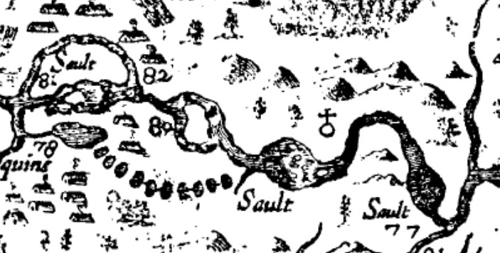
It is this 1632 map of Champlain’s that we will study and compare to the actual existing geography of the region. Leaving the Chaudiere Falls in Ottawa on June 4 1613, Champlain made his way up the Ottawa River with his canoes and native guides, making it as far as Chats Falls near Fitzroy Harbour. Here they portaged around the falls and made it to the Chenaux Rapids where they decided to portage west, through an area just north of Renfrew.
Close-up of the 1632 map showing the area of The Ottawa River.
Specific landmarks are noticeable on Champlain’s 1632 map, such as Chats Falls and the islands.
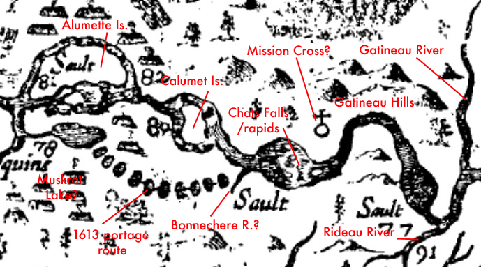
Comparing the 1632 map to a current aerial map, we can distinguish and use certain landmarks to establish Champlain’s route in 1613. Colours correspond to matching areas on each map.
It is at this point that details fade, and Champlain’s exact route is unknown. What is known, is that Champlain left the Ottawa River in an area called Brown’s Bay on June 6 to traverse overland following a string of lakes up to Pembroke. His journal makes account of travelling west: “Thus after having passed four small ponds and walking two and one half leagues, we were so tired that we could go no further…therefore we stayed by the edge of a pond, which was pleasant enough, and made a fire to drive away the mosquitoes which molested us greatly.” Champlain on the next day June 7, states in his journal entry “We passed this pond, which may have been a league long” and carried onwards towards Pembroke, losing his astrolabe near Cobden as he travered the difficult terrain. Studying Champlain’s 1632 map, I made some observations in relation to his journal entries. The map is actually a fairly accurate representation of the land and indicates prominent landmarks when compared to a modern satellite map of the same area (see diagrams) After overlaying his route with current maps, it is actually plausible that Champlain did indeed travel near the Champlain Stone on his portage, and the stone does actually in fact lie very near the shore of a large pond.
Champlain’s route in 1613 with points of interest marked.
THE CHAMPLAIN STONE QUESTIONED
If the Champlain Stone is indeed a hoax, then why was it made and who did it? Comparing the map route of Champlain, it does put him in the area where the stone was found. It does lie on the shore of a pond that is mentioned in Champlain’s journal. It is a unique rock formation that stands out and would make a good landmark if one wanted to leave a record of your travels past it. The date inscribed on the stone is June 7, which also matches the date he would have been in that exact area according to his journal entries. If the stone is not authentic, then why would someone make a stone with an inscription in the deep woods with the hopes that someday someone would find it? How did the potential hoaxer know so much about Champlain and his journey to write the date of June 7 that exactly matches Champlain’s journal entry?
The Champlain Stone was never studied further or analyzed for authenticity, so it is unsure how long ago the letters were carved into the rock. Were they carved 400 years ago or were they carved 60 years ago? Without further study, we can not definitively prove its age. The Champlain Stone remains a mystery as to why and who would make an inscription on a rock deep in the Renfrew woods. Possibly some day someone will come forward with more information on this oddity, but until then, it sits silently forgotten, slowly being enveloped by the woods from where it was discovered. It remains a piece of an Ottawa puzzle that may never be solved.
SOURCES
The Upper Ottawa Valley: A Glimpse Of History Clyde C. Kennedy 1970
Another landmark and rare sign in Ottawa was removed this month.
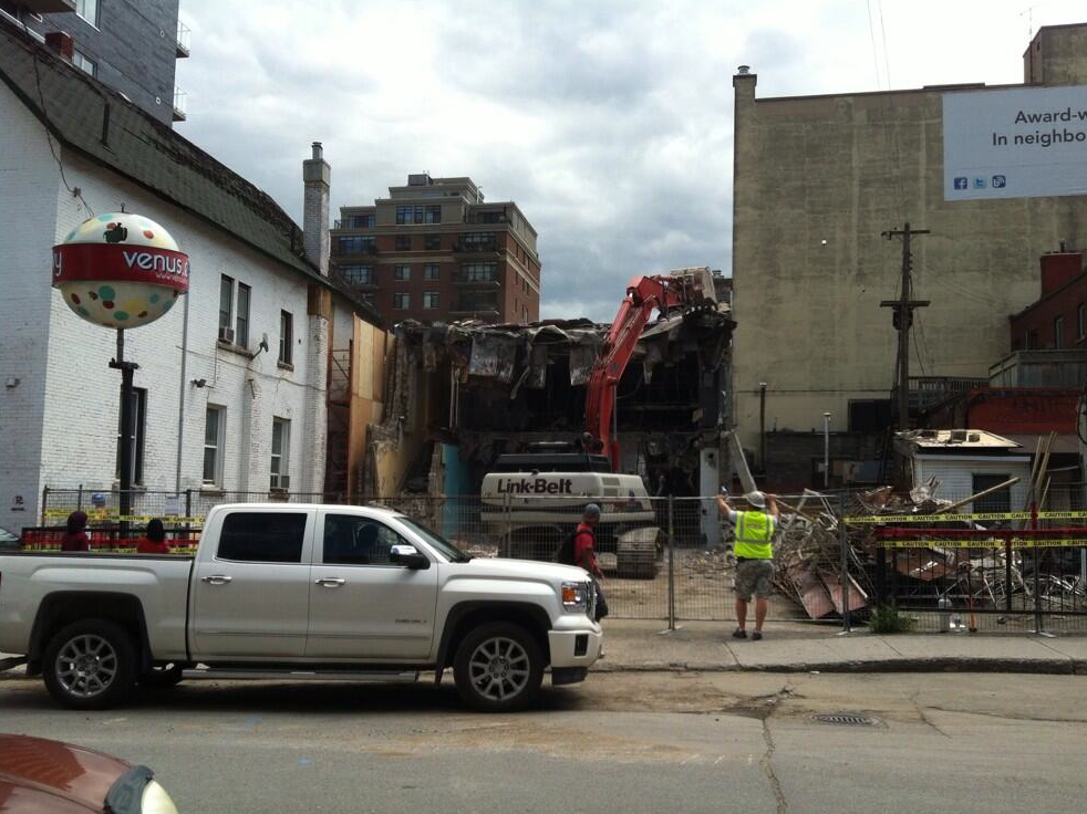
I have been keeping my eye on a special piece of Ottawa history at risk and thankfully the owner of the property at 320 Lisgar St. recognized the importance of the landmark sign on his property and saved this Ottawa icon. According to to a new Ottawa Citizen article, Arthur Loeb saved the sign after the building on his property was slated for demolition.
On July 4th demolition crews demolished the building at 320 Lisgar St, a former laundromat and more recently, home to Venus Envy, a business that has since moved from that location. Now the building itself was nothing special, a typical late 1960s concrete and glass structure. But it was not the building that was special, it was what was outside it that was: THE NORGE BALL. A complete and detailed look at this unique sign can be found here at RoadSideArchitecture.com
On July 4th the old Norge Village Laundromat and former Venus Envy store was demolished but the rare and iconic “Norge Ball” was saved (photo via Twitter @venusenvyottawa)
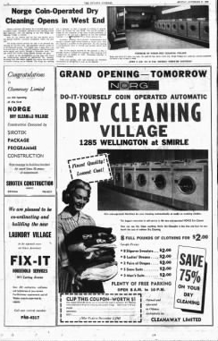
Once part of Norge Village Cleaners, a nationwide laundromat chain out of Chicago, these signs were a unique aesthetic. Norge developed these plastic, polka-dotted ball signs, appropriately nicknamed “Norge Balls” during the 1960s as their corporate signage. Approximately four feet in diameter, these rare signs would be illuminated and rotated on a fixed pole.
Ottawa had a few locations across the city and ads of the time boasted that the user could do “personal dry cleaning similar to a coin-operated washer. You simply open a glass door, toss in an arm load of clothes, insert quarters, and the machine whirls gently and quietly through a 50-minute cycle.”
Original Norge Village Laundry ad in the 1961 Ottawa Journal.
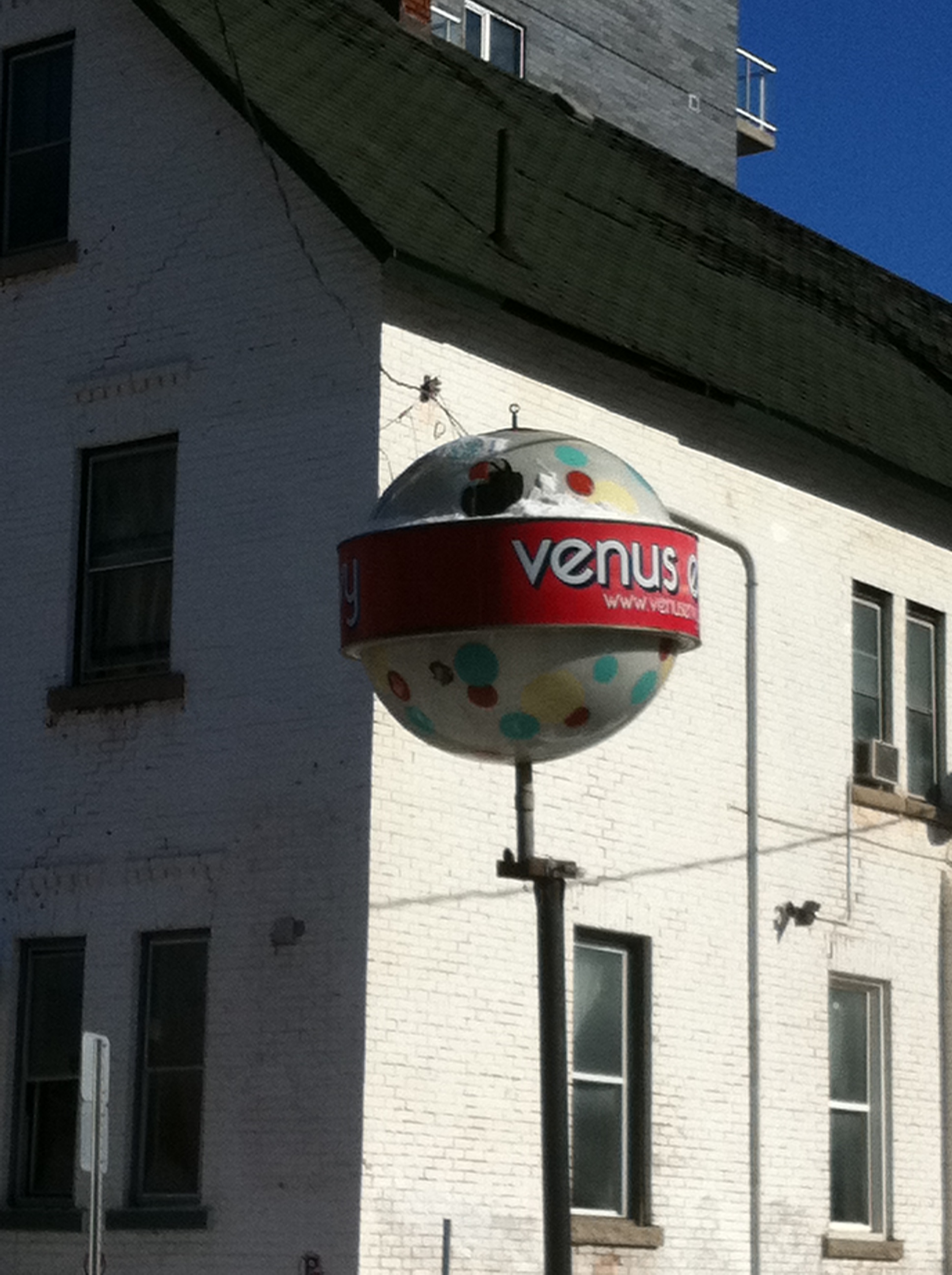
A popular landmark in the city for anyone that passed it off Bank St. this polka-dotted elevated orb elevated on a metal pole was a unique piece of history that has been removed like many other classic signs in Ottawa. It reminded us of a time when signs were carefully designed and built, adding to the unique visual streetscape of our city.
The Ottawa Norge Ball sign is one of only about 60 known to still exist out of an original 3,400 made. It was reportedly the only one to exist in Canada.
Of the 3,400 original Norge Balls made, only 60 are known to exist, with Ottawa having the only one known to still exist in Canada. A rare sign whose fate is thankfully safe from destruction. So many of these classic Ottawa signs are lost and I’m very grateful to Loeb that the sign has been thoughtfully removed and stored for possible future use. I have been working with a local business over the last few months designing their new signage and we have discussed how we would like to re-purpose and restore this sign and bring it back to its former glory so residents can continue to enjoy this rare and unique Ottawa icon.
Farewell to an Ottawa icon, the Norge Ball off Bank St. on Lisgar St. was one of the few remaining Norge Balls known to exist in North America.
With info from http://www.agilitynut.com/signs/norge.html
A look at how an adandoned 1950s railway to Ottawa’s Airport could solve some traffic problems…
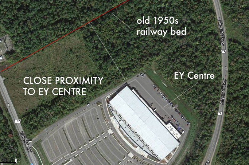
Being the Nation’s Capital, Ottawa is host to many conventions and events at the newly constructed Ernst & Young Centre, a marvellous convention space located at the Ottawa Airport. It is widely used and attended by thousands of people each year but unfortunately it can only be easily accessed by the Airport Parkway and Uplands Drive, which undoubtedly causes traffic woes when an event at the EY Centre is taking place. Compound this with air travellers trying to catch their flights at the airport and you now have people missing flights because of convention traffic if they don’t allow for the delays. This problem will get worse as our city grows and more people use the convention facility. A solution may be to resurrect a long forgotten 1950’s railway spur that used to connect the still operating O-train/CP line to the airport.
A LOOK BACK
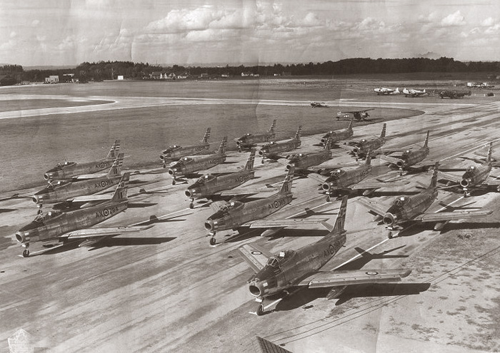
Ottawa’s Upland Air Force Base in the 1950s. The railway to the airport was built to carry construction equipment used to expand the new air base. (photo Vintage Wings Of Canada)
When the Ottawa Airport was a World War Two training base, it was called Uplands Air Base, or No.8 Service Flying Training School. It trained pilots for service as fighter pilots during the war, but when the Second World War ended, Uplands became home to the jet age, and CF-86 Sabre fighter jets were stationed there as well as many other military aircraft. This called for a massive extension of the old airport with new runways and hangers having to be built. To accommodate the large scale construction, materials had to be brought in on a massive scale, so a rail spur line from the existing Canadian Pacific railway was built. Materials for the new air base construction could now be easily transported into the airport from the St. Lawrence river docks at Prescott.
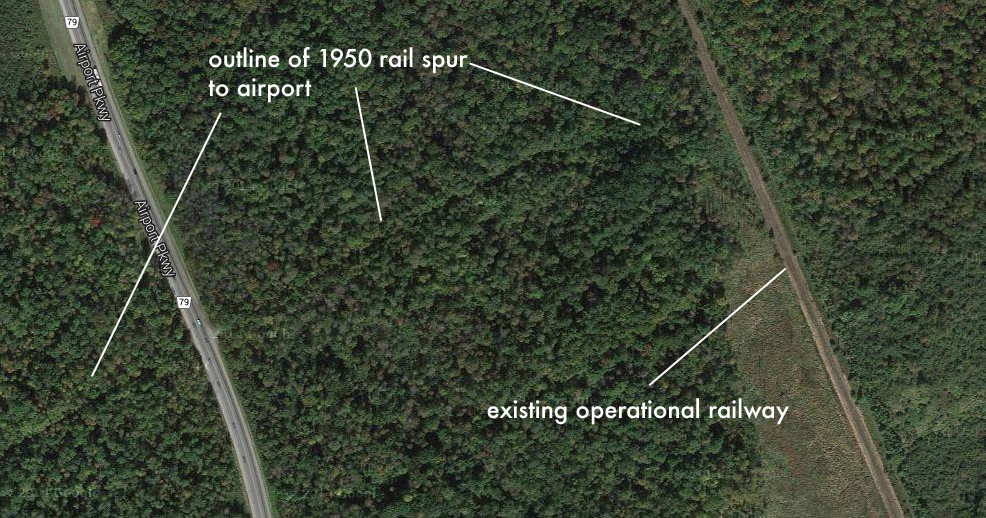
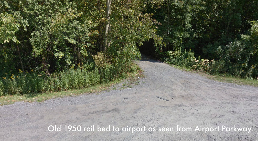
The 1950s rail spur line curved west from the CP line and crossed the current Airport Parkway where it terminated over by the airport hangers and terminal. It was used to bring in munitions, equipment and other material during the busy Cold War days of Uplands Air Force Base. The rail line was abandoned sometime later when the base closed and the railway was no longer needed. The tracks were pulled up, but the the gravel rail bed still exists and remnants of it can be seen today.
USING IT TODAY
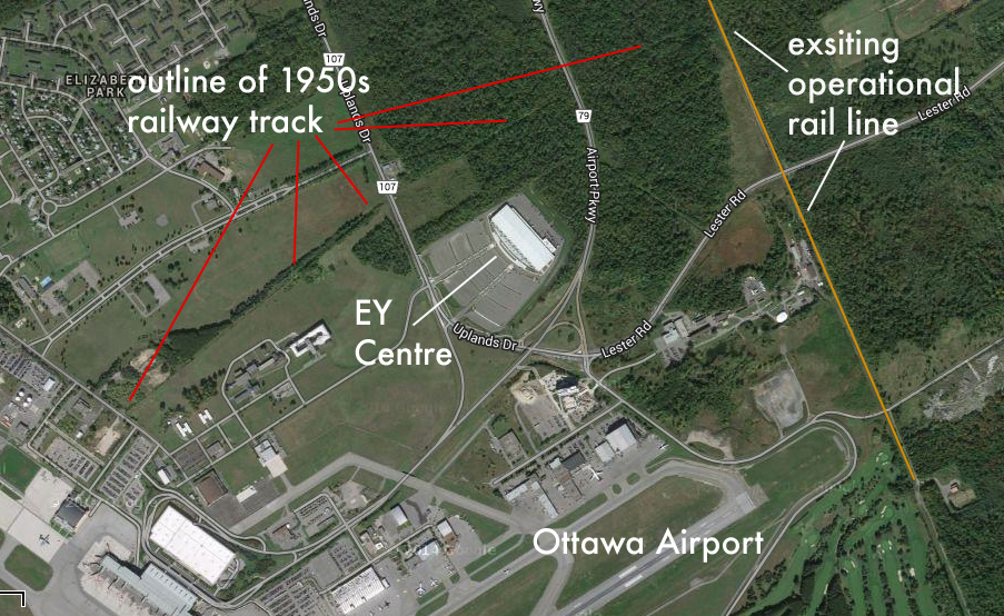
With the O-train currently using the existing CP track, an extension spur could possibly be resurrected using this old 1950s rail bed. The old railway passes very close to the new EY Centre and with a station there, it could be used to bring visitors to the convention centre from the downtown with ease and also ease car traffic congestion that seems to be a growing problem. The line could then continue west right over to the airport terminal, giving air travellers a swift, efficient option of entering and departing our airport.
The old Uplands ghost train could be brought back to life by placing new tracks on the old railbed and in the long term, provide our fine city with the airport train service it needs and deserves.
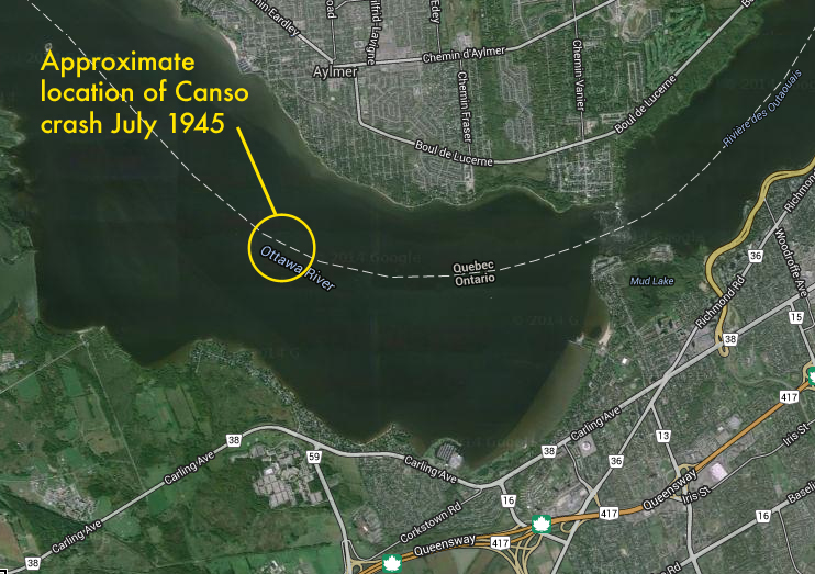
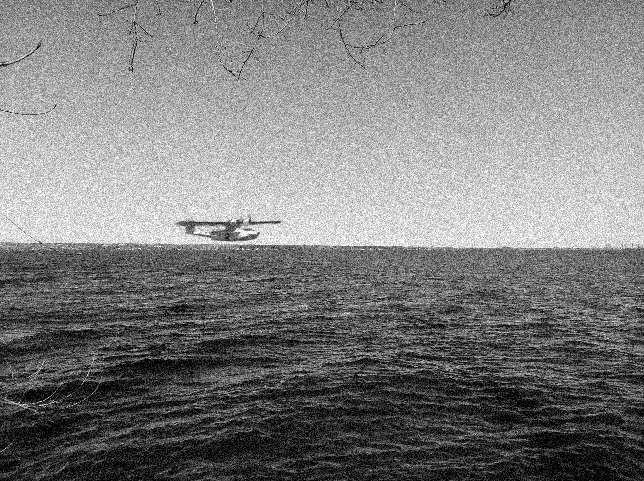
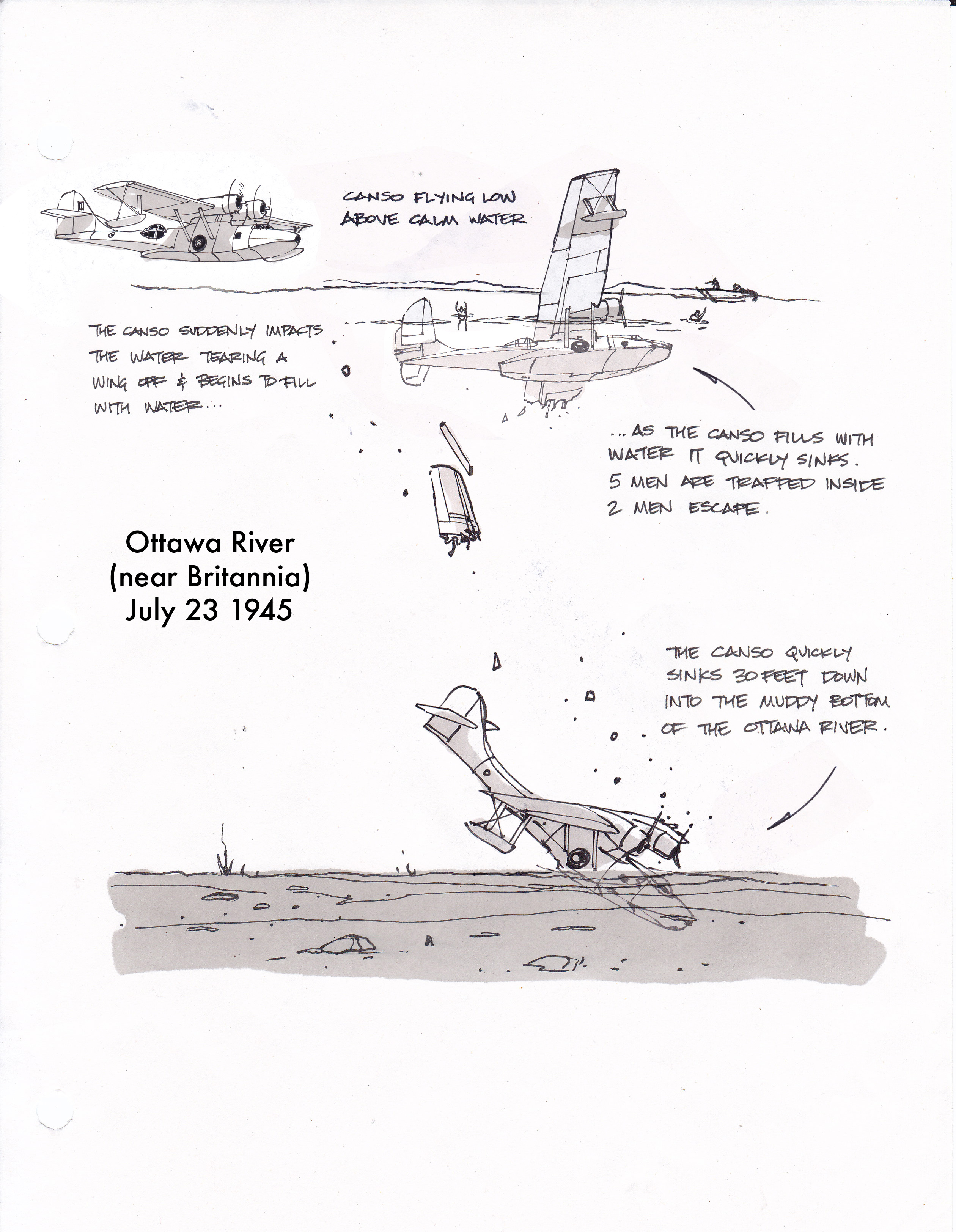
As cottagers sipped lemonade on the shores of the Ottawa River near Britannia on a hot July afternoon, relaxation turned to terror as they witnessed the tragic crash and sinking of a 100 foot flying boat. Five of the seven man crew perished that warm summer day as their flying boat quickly sank under the glassy surface of Britannia Bay. Trapped inside the sinking hulk of the Consolidated PBY-5A Canso, it would only take five minutes for the men inside to be taken to their watery grave at the bottom of the Ottawa River.
Map showing approximate crash site of the PBY Canso July 23 1945.
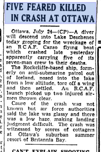
Original 1945 Toronto Star newspaper article reporting the tragic crash near Britannia.
WHAT HAPPENED?
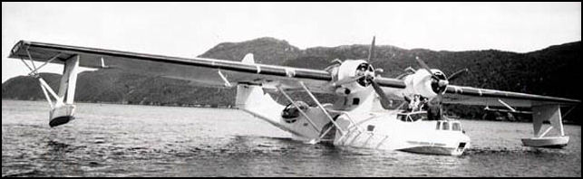
It was just after 3 o’clock on a hot, calm July 23 in the year 1945 and the waters of the Ottawa River were as smooth as glass. Having just returned from active duty in Iceland patrolling for German U-boats during the last months of WW2, the giant PBY Canso flying boat, serial number 11023, was now part of the Rockcliffe based No.162 Squadron which specialized in photo reconnaissance. Originally built in Montreal in 1943 at the Vickers Canada factory, the 100 foot wingspan radial twin-engined flying boat was conducting practice take-off and landings in Lake Deschenes, a body of water that stretches north upriver from Britannia Bay.
The amphibious PBY-Canso sitting in the water showing its large stature.
A concept image showing the section of the Ottawa River and the Canso that was flying over it in 1945 (looking east from Shirley’s Bay shore line)
The still, calm waters may have seemed pleasant for the many boaters and swimmers in the area, but proved deadly for the floatplane since the surface can be like smooth cement at high speed. This is thought to have contributed to what happened next. The plane took off without incident near the shores of Aylmer and circled over Shirley’s Bay, dropping low to land heading towards Britannia Beach. Suddenly the still, glassy water caught the plane in a disastrous manner, tearing off part of the wing, flipping the aircraft over and tearing a gaping hole into the hull.
Listing to one side with 5 of the 7 man crew still inside and 2 men thrown clear of the aircraft, the plane quickly filled with water. Shocked cottagers watching the incident from their lawn chairs quickly jumped into their boats and sped towards the crash to assist in retrieving survivors from the wreckage. Within a minute the hull had slipped sideways into the depths of the river, tipping the 100 foot wing on end, like a massive sail sticking straight up out of the water. Two men trapped inside desperately tried to free themselves from the sinking wreck, but within minutes the aircraft submerged, taking all those still aboard with it. Two of the crew were pulled from the water into waiting boats as an RCAF crew member in a nearby boat courageously jumped into the water trying to reach the submerging plane in a desperate attempt to free those trapped underwater. AC Nightingale would later be awarded a medal for his bravery trying to save the doomed crew members. The plane quickly dropped into the murky depths and sadly no one else could be saved. The wreckage of the Canso settled and sank into the muddy bottom of the river where it would remain for several days.
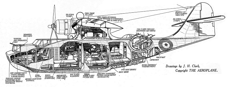
Cutaway of the Canso showing the various crew compartments.
Pieces of the plane, equipment, fuel, oil, log books and other remnants floated to the surface as well as a few of the dead crew members. Divers tried to recover the remains of the crew members still inside but were hampered by the muddy silt now enveloping the plane. A tug boat was hired to attach cables and chains to pull what was left of the Canso to shore in Aylmer where it was hauled out of the water.
The salvaged remains of the once mighty flying boat were then transported to Trenton, ON No.6 Repair Depot where records show it was catalogued as “scrap” and never heard from again. Does Canso 11023 still exist in a scrapyard somewhere? Is this tragic piece of history sitting in a junkyard, its story slowly becoming lost in time? It is unclear if the remaining underwater wreckage of the ill-fated Canso were ever recovered from the depths of Britannia Bay. If the plane broke apart upon impact it is likely that pieces still remain on the bottom today, covered in almost 70 years of silt and mud.
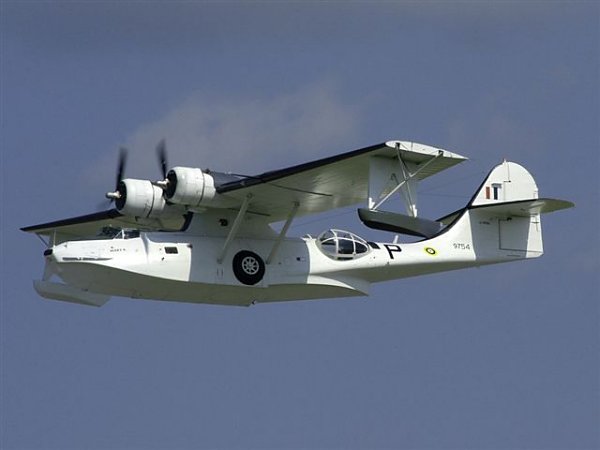
The Canadian Warplane Heritage has a flying example of the Canso that operates out of Hamilton, ON.
The Canadian Aviation and Space Museum here in Ottawa has a complete un-restored example of this unique flying boat in their collection and the Canadian Warplane Heritage in Hamilton, ON has a flying example of this famous U-boat hunter that once patrolled the waters of the North Atlantic. Perhaps one day we will search below the waters off Britannia and recognize the plane and the crew that slipped below the calm waters of the Ottawa River on that hot summer’s day in 1945.
The history of Canada’s National Capital Region is always filled with stories of endurance and perseverance, of overcoming great obstacles in an undeveloped land consisting of forest and swamps. The first settlers in the Ottawa region came to an area inhabited by nomadic native Algonquin tribes with no real permanent structures, a land that was a clean and fresh piece of Canadian wilderness. So what was the first permanent structure to be built in our Nation’s Capital, who built it and where was it? Maybe an even bigger question can be asked: why is it not marked as a significant historical landmark in our capital region?
THE SEARCH BEGINS
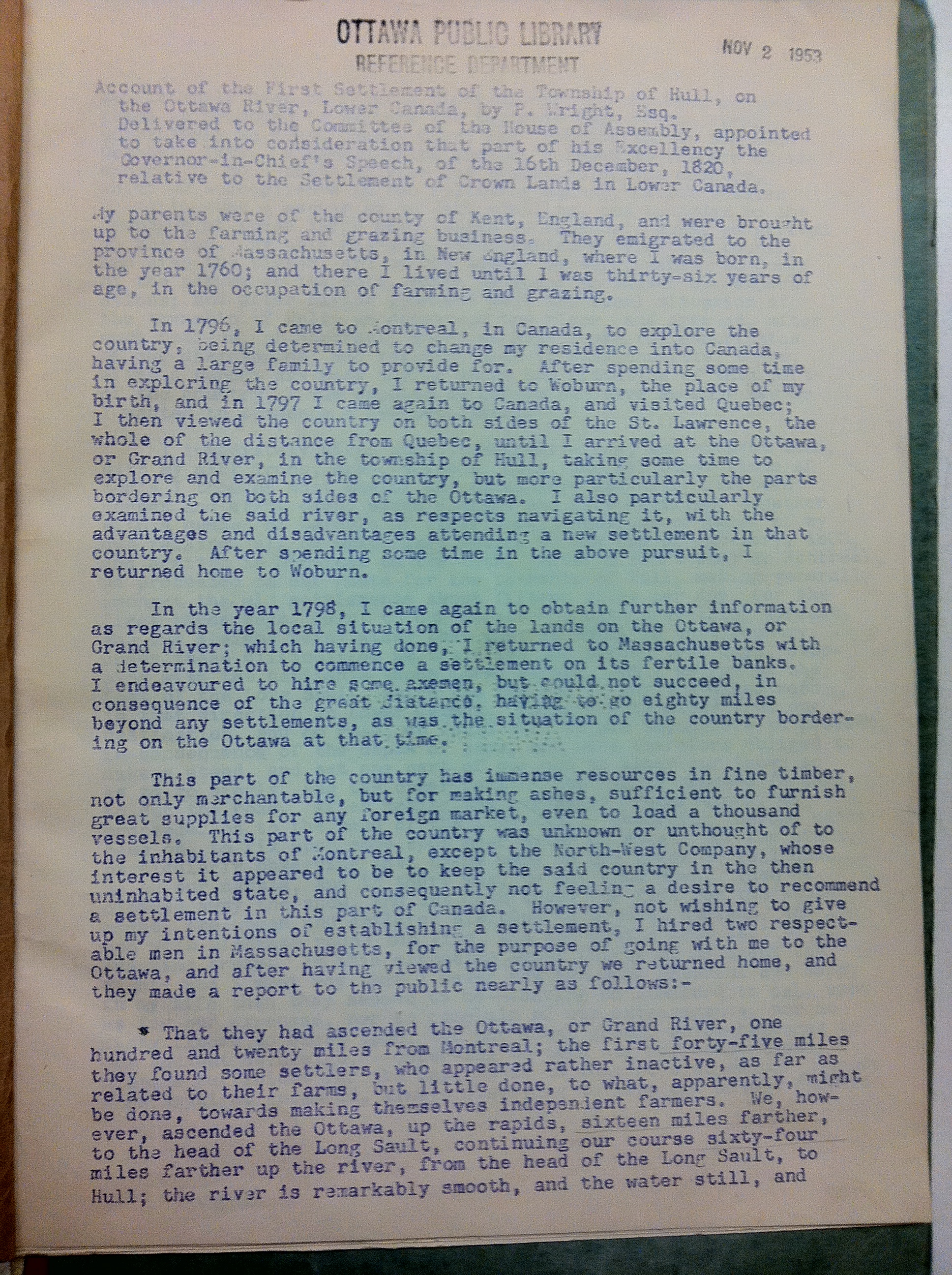
History tells us that the first non-native settler to set up permanent residence was a fellow by the name of Philemon Wright. With most of Canada being settled by the French and British, it only seems logical that the first settlement in the Nation’s Capital would be built by someone from either of those nationalities. Surprisingly, that is not the case. The first permanent settlement in Canada’s Capital was built by an AMERICAN.
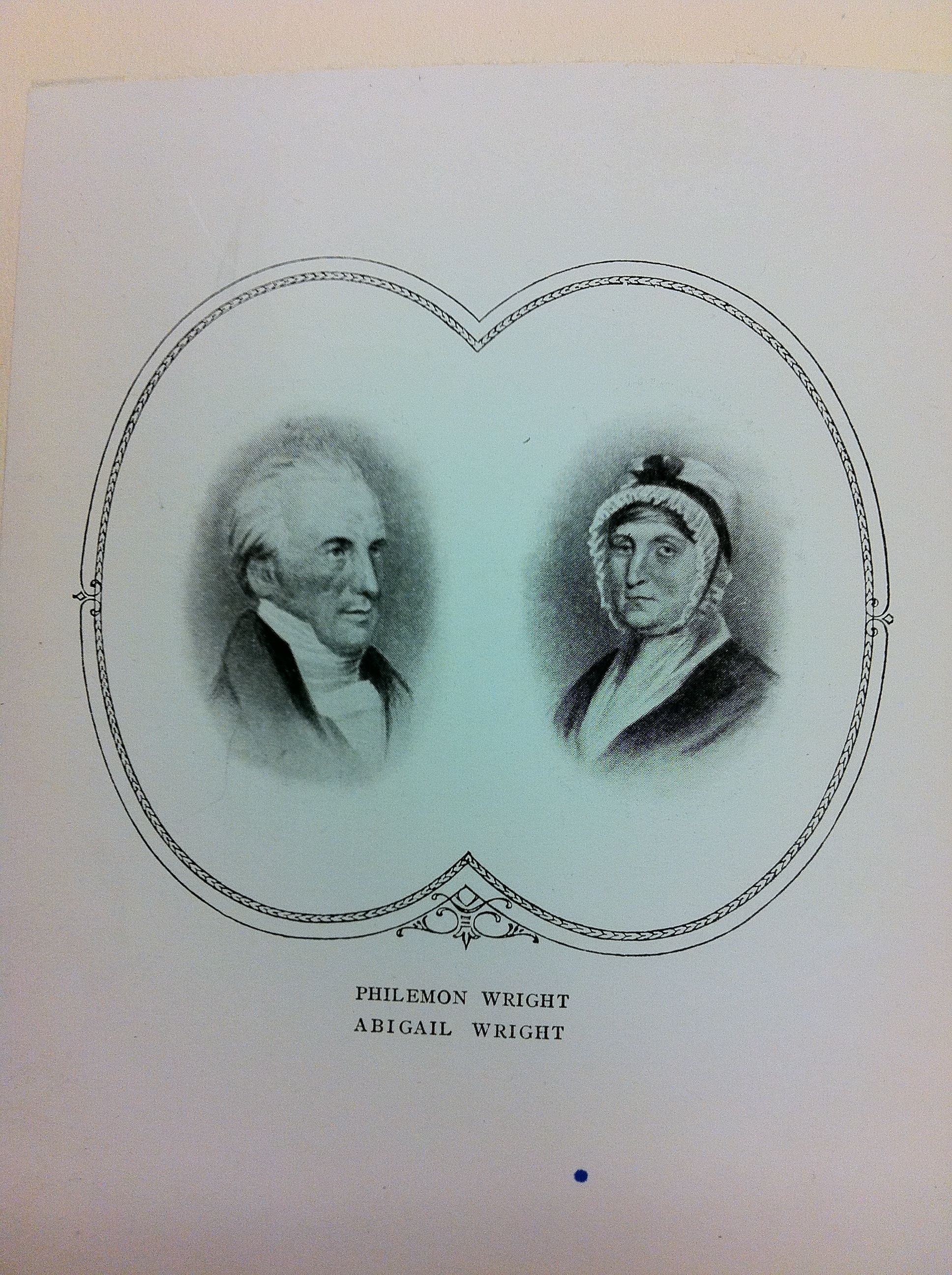
American ex-patriot Philemon Wright left Woburn, Mass. in 1800 with his wife, children and 45 others to settle what is now the National Capital Region.
Philemon Wright was an American who lived in Woburn, Massachusetts and dreamed of leaving the growing suburb of Boston for a new land, to create a prosperous new life in a fresh, untouched part of the continent. That part of the continent was the the unsettled land of Ottawa/Hull, a land that was being divided and given to men who would make it what it is today. Having fought against the British during the American Revolution, Wright knew it would not be an easy task to secure land now under British control.
Lucky for Wright, British authorities at the time were seeking to populate the vast new lands of their colonies. They arranged a program to have group settlements in the wilds of Canada. Interim land grants were given to leaders and associates, then the associates would hand over portions of their land grants to the leader as payment to the leader who did the exploration and surveying. One of these leaders was Philemon Wright, who visited Lower Canada often, specifically the area of Ottawa/Hull. After numerous visits to this area, he applied for a land grant to the British Empire. They approved his grant for a land settlement in this unknown land west of Montreal under one condition: Every adult male in his settlement must swear an oath of allegiance to the His Majesty, the King of the British Empire.
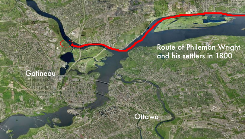
Wright’s 1800 journey northward from Massachusetts to Ottawa.
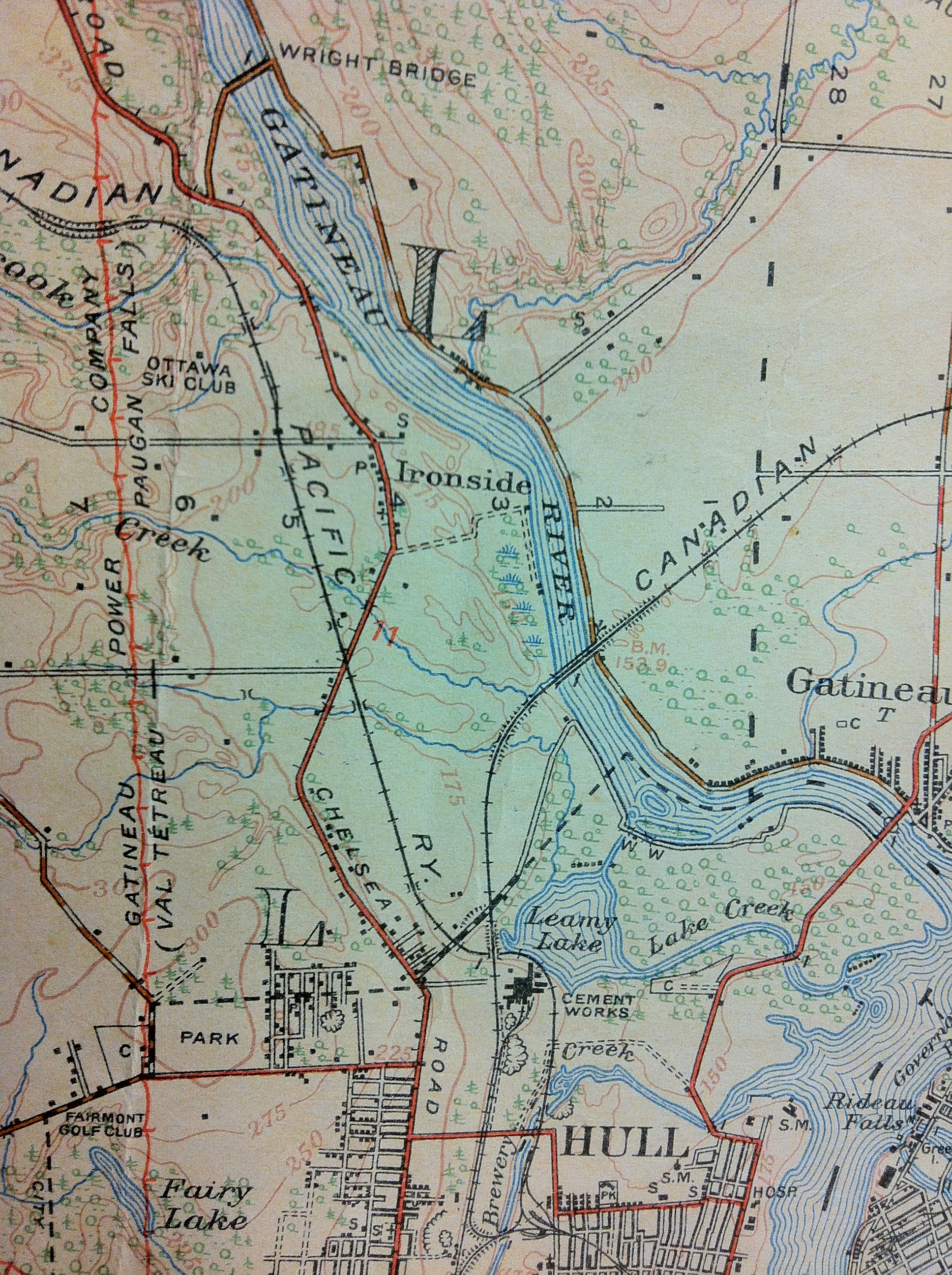
He convinced a number of his Woburn neighbours and family members to sign over their land grants to him, and join him as “associates” on a journey north to settle a land no other European had settled. With 50 men, women and children, labourers and axemen, Wright set off in horse-drawn sleighs in February of 1800 for Montreal. Arriving in Montreal in March, Wright and his men swore allegiance to the King Of England and received their land grant for an area where three rivers met, the Ottawa, the Rideau and the Gatineau. His land was to become what is now Lac Leamy Park.
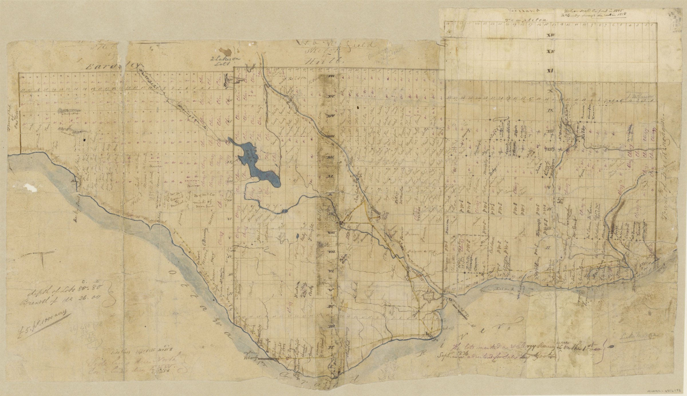
A map from 1836 that shows Philemon Wright’s land grant.
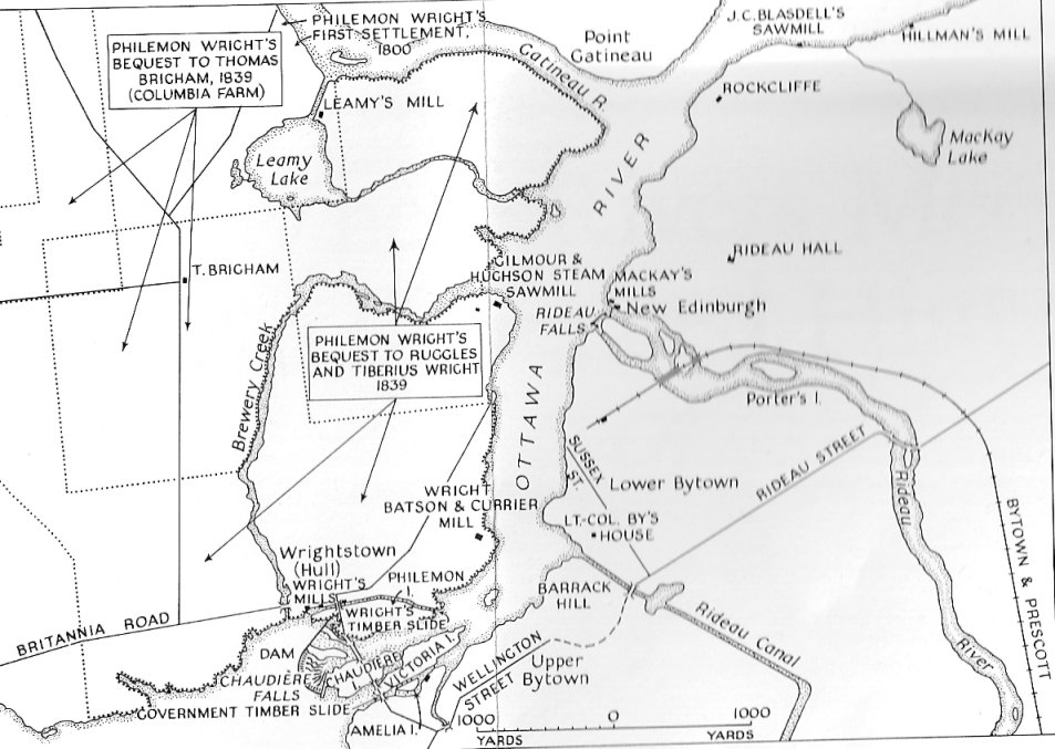
Crossing the frozen waters of the Ottawa River, Wright and his settlers arrived on the shores of the Gatineau with the aid of an Algonquin guide, who showed them safely to their new home. Philemon and his crew went up the steep embankment 20 feet from the shore and began to clear the area of trees, using felled logs to construct what would become the very first permanent home in the National Capital Region. Wright had soon cleared the land and built a farm, and also a road to the Chaudiere Falls where he built the first mill and began a logging empire that continued for over a hundred years. Wright moved from his log cabin to a new home he built in Wrightstown, the town named after him that sprung up around his mill at Chaudiere Falls that would later be re-named Hull. In 1835 he sold his original home and farm, which he called Columbia Farm, to Andrew Leamy, which the area and lake are currently named after.
A map showing both Wright’s and Leamy’s properties.
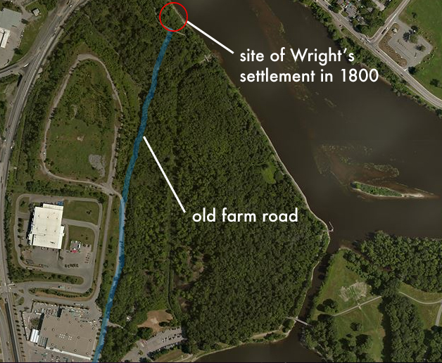
LET’S GO THERE NOW
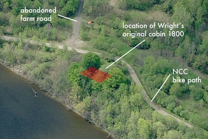
So now that we know where Wright landed and built his log cabin, what is left, if anything, of this original settlement? Old maps show his land and Columbia farm, and the original farm road is still in existence, although abandoned. The majority of Wright’s settlement is on NCC land at Lac Leamy Park in what is now Gatineau. The original Wright farm road, which led from his original log house to his prosperous mill over by Chaudiere Falls partially remains, but what of the original cabin from which the road led to?
Looking at old maps from the Ottawa Public Library, Wright’s personal memoirs of the first settlement, and researching various NCC and historical information about the area, we can put together a pretty good picture of what was and is there now.
1820 personal account by Philemon Wright of his first settlement twenty years earlier.
A log building that was still standing in 1884 on Leamy’s farm was probably Wright’s first home. The Wright family called that home “The Wigwam”, and it is referenced numerous times in many historical accounts. The house itself was built as Wright says in his memoirs: “…built of undressed tamarac logs in true rustic shanty fashion. The chinks between the logs and scoops of the roof were caulked with mass, driven in with a thin pointed handspike, over which a rude plaster of blue clay was daubed. The chimney was very wide and low, and was built above a huge boulder which formed the back of the fireplace. There was no upper story to the rude dwelling, which was partitioned off into bedrooms at each end, with a large living room, kitchen, dining room all in one, in the centre.”  
A similar style log cabin to the one Wright built on the banks of the Gatineau River in 1800.
    
Unless the cabin was maintained and restored frequently, the chances of this original building remaining today are very slim. One account says the original cabin was moved in the 1950s to some unknown location within the city of Hull. Has anyone seen a log cabin in Hull? Please let me know if so! Whatever remains of it would not be much, so locating the site would be difficult. This is where the maps come in… MAPPING HOUSE ONE
Using old maps we can see a variety of structures and the general area where Wright’s cabin could be located. NCC archeological documents identify a Wright dig site that was examined as file Name “Bi-Fw-24”. Using that code name, we can zero in on documents that reference that name. Recent STO transit studies that converted the nearby train tracks into a RapidBus transitway had an archeological assessment done and they identify the Wright home in their report.
An NCC website proclaims they found the original site of Wright’s home, but no other recognition is given: “While stabilizing the shoreline of the river, the NCC conducted archaeological salvage excavations at the site of Wright’s original house. A wealth of domestic items were found, including earthenware pots and dishes, cutlery, buttons, religious medallions, combs and dolls.”
And: “It was the conclusion of another archeological dig at that site that the foundations of that house dated from the early 19th century. The location was reburied for preservation and protection and the NCC has plans for future commemoration of the site.”
That NCC archeological investigation was in 2006. No marker, plaque or commemoration has been displayed since.
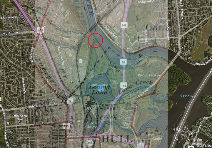
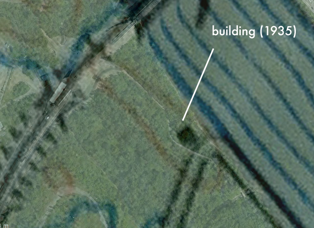
A Department Of Defence map from 1935 shows a structure, most likely the Wright cabin or a building from his homestead, at the end of the original farm road. Ghosting images together of these old maps with current aerial imagery provides us with accurate locations from which to investigate possible remains of Wright’s cabin.
1935 Department of Defence map showing building at the end of the Wright farm road.
Ghosted 1935 map over current aerial map. (Wright building circled in red)
Close-up of 1935 map ghosted over current map.
FIELD INVESTIGATION
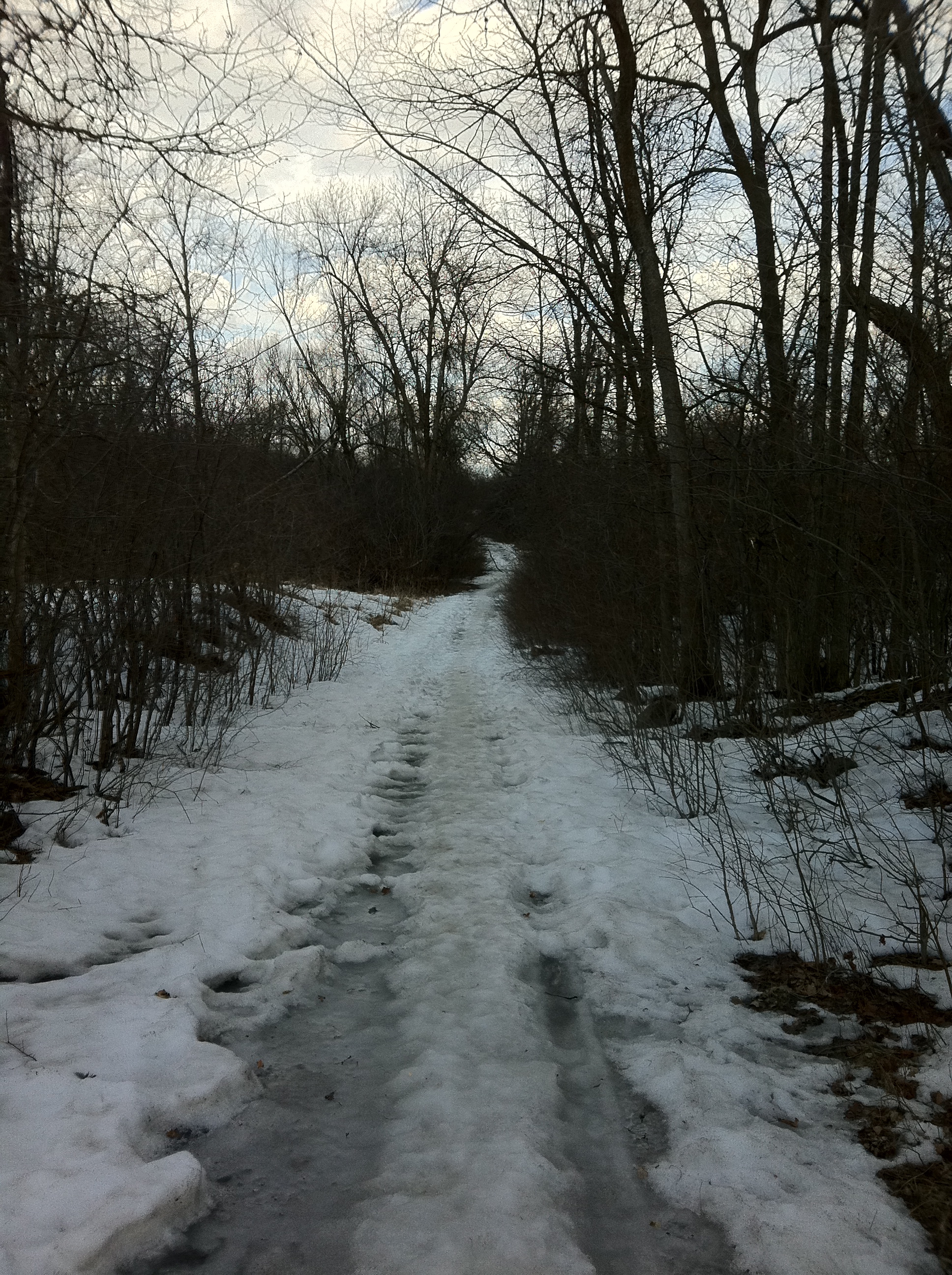
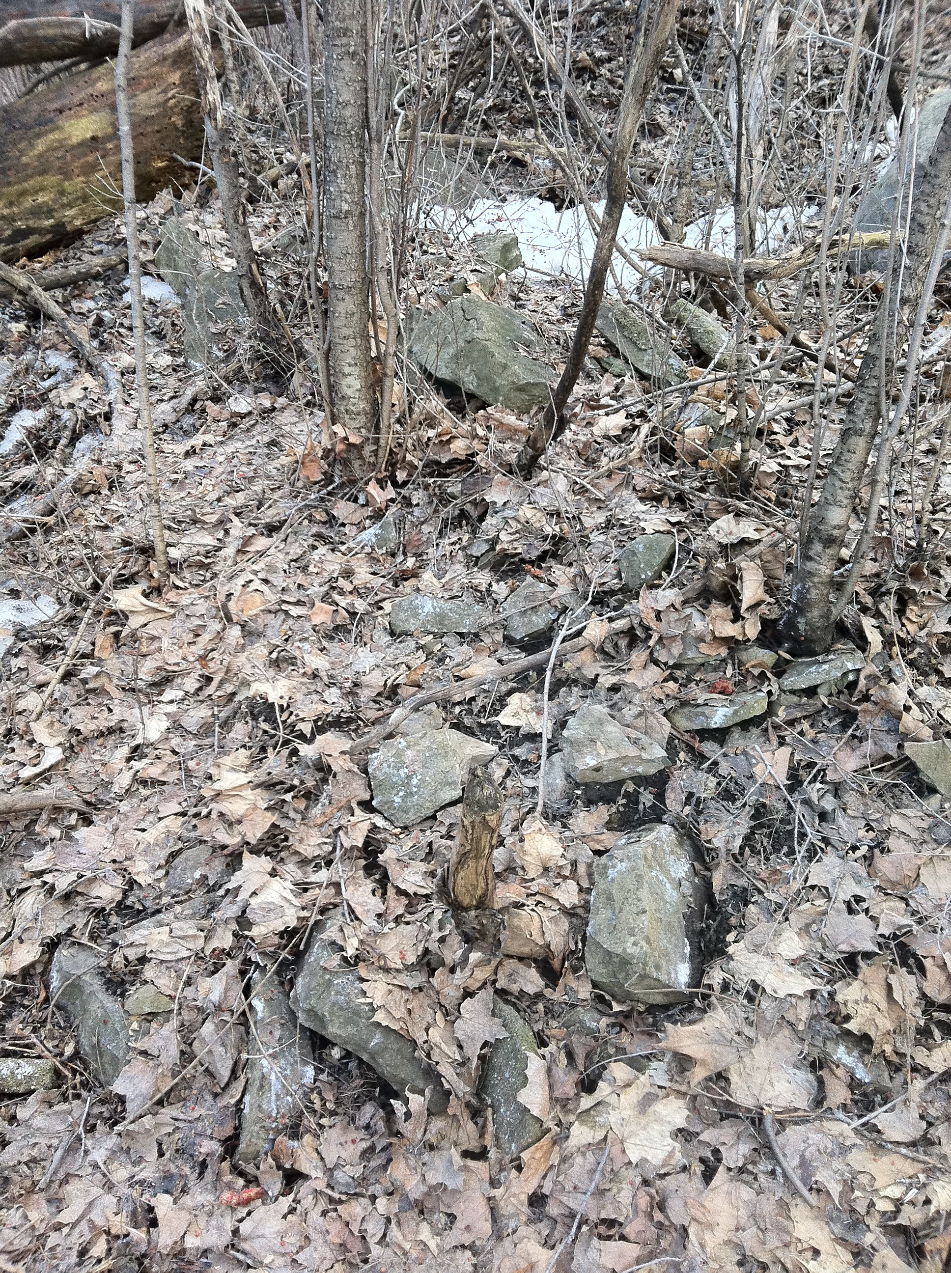
Packing a camera and a GPS, I was determined to locate this incredibly important piece of Canadian history. Joined by fellow history buff and friend Glen Gower, we headed out to see what we could find. The original old farm road, which is likely one of the oldest roads in the region, was easily located and traversed.
Using GPS coordinates from the map research, the location of Wright’s landing settlement was established and a survey of the area was conducted. The farm road ended at what is most likely the site of Wright’s house. The area was searched and some clues were found.
The abandoned Wright farm road leading to the site of his original cabin, possibly the oldest in the Capital Region.
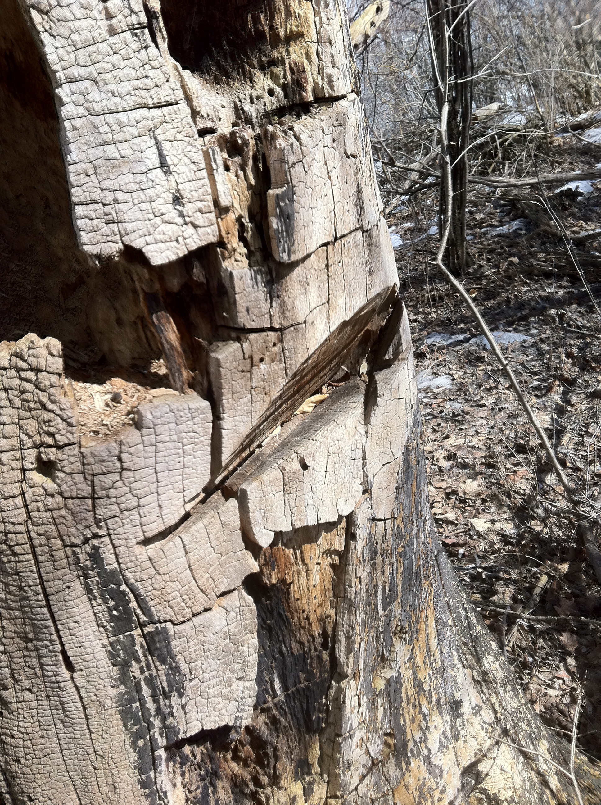
An overgrown trench had been previously dug across the area, which is a common archeological technique when investigating a site. Axe marks were found on large, dead trees in the vicinity. Whether these are from 1800 when Wright’s axemen were clearing the land, or recent chainsaw marks has yet to be determined.
1800 axe marks or chainsaw on this old dead tree?
A mass of tumbled stones on the site could be remnants from the first settlement.
A mass of stones tumbled over an area of about 8-10 feet were discovered. This could possible be fireplace or foundation remains from the original cabin. Also noted was a deep pit dug into the ground nearby that may have been the outhouse latrine or a well.
In comparing the site to Wright’s notes, the area is indeed set back 20 feet from the shoreline of the Gatineau River, atop a steep embankment as he described.
Wright’s description of the initial landing on a steep bank of the Gatineau River.
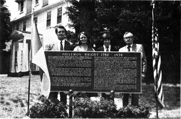
Considering these clues, the maps, the archeological reports, and comparing to Wright’s own memoirs about the site, I can almost certainly conclude this site, a barren, overgrown, area off an NCC bike path, is the resting place of the very first home built in the National Capital Region. If not exactly there, it is very near by. It seems a shame that no marker or plaque commemorates the spot where our Capital was born.What’s even more bizarre is the fact that in 1980, the NCC and US State representatives erected what was the largest free-standing cast plaque in North America commemorating Wright’s settlement on the site of Wright’s original home….IN WOBURN, MASSACHUSETTS. The founder of Ottawa, Hull and Gatineau lies buried in a simple grave a few kilometeres away from his original home, but no plaque marks the inception point of what was to become Canada’s Capital Region.
In 1980 a plaque, the largest free standing cast plaque in North America, was unveiled by the NCC and US State representative’s in Wright’s hometown of Woburn, Mass.
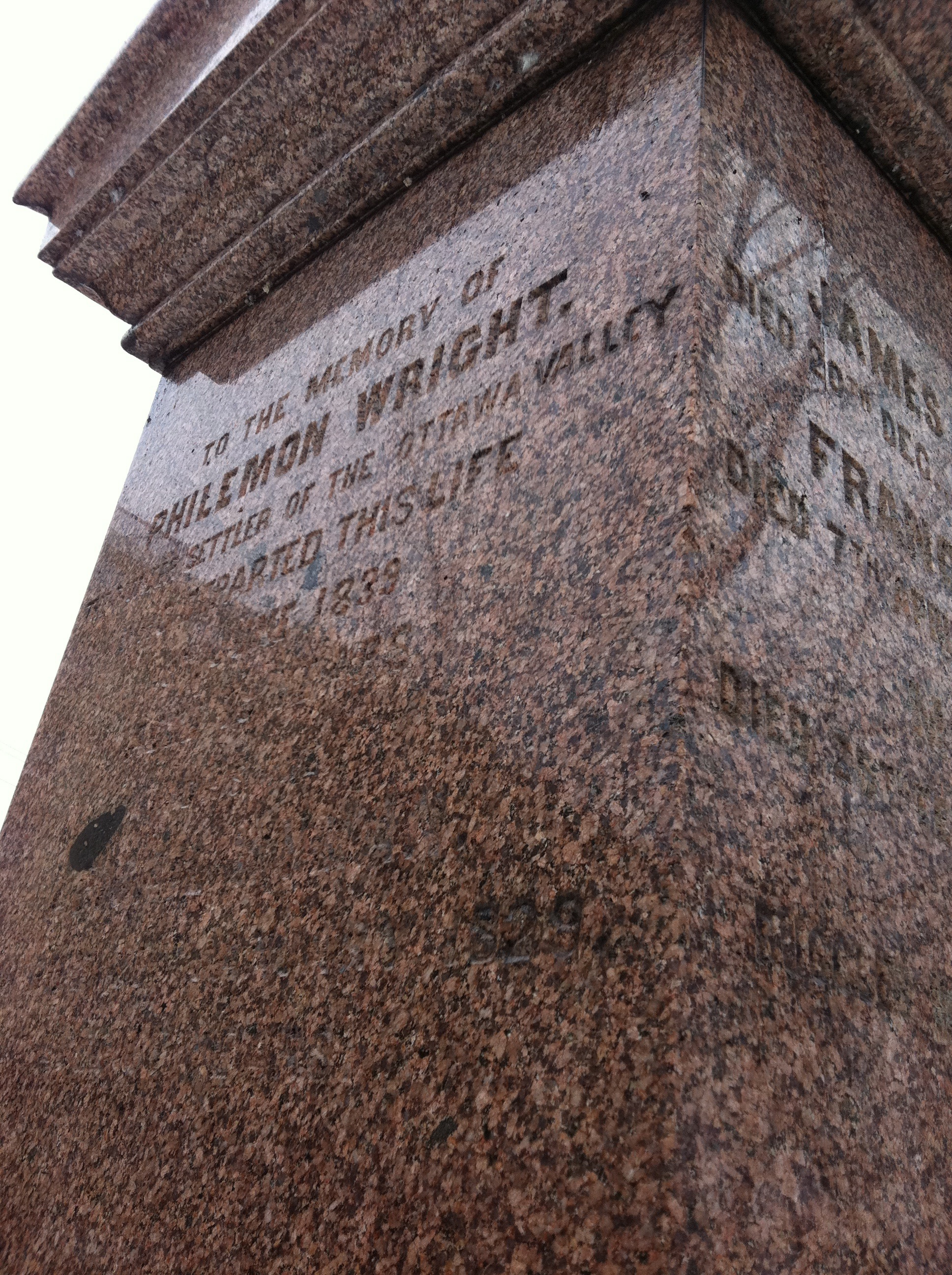
Gravestone of Philemon Wright, just west of the Chaudiere Bridge.
For whatever reason there is no plaque or any other indication of where Wright founded our city at the site. Whether or not it is because Wright was neither French nor British, but an American ex-patriot who founded the cradle of Canada’s Capital, this place is historically special and needs to be recognized. As a resident of this area I was saddened to stand on the spot where the man worked so hard to create a life for himself, who created a place that we call the National Capital Region, had nothing there to commemorate his efforts. Maybe because it is too remote, just a piece of overgrown NCC land in Gatineau, away from the downtown core, it remains ignored and forgotten. I would like to think that the legacy of Wright and what was our area’s first home, House One, will one day be made a place for all of us to visit, enjoy and remember in the years to come.
SOURCES
“Account Of The First Settlement Of The Township Of Hull, On The Ottawa River, Lower Canada”. By Philemon Wright, 1820. Ottawa Public Library.
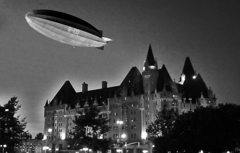
How the R100 may have looked as it hovered over the Chateau Laurier on the night of August 10 1930.
One summer’s eve in 1930, the warm night air became filled with the roar of engines as a colossal object hovered over the downtown Ottawa skyline. Cars stopped in their tracks, thousands of people ran from their homes, restaurants and movie theatres, staring skywards at a massive shape that was slowly filling the night sky…it was the Night Of The Zeppelin.
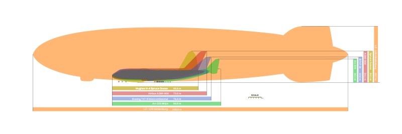
The age of the mighty airship arrived in Canada in the summer of 1930 when the newly constructed R100 completed its maiden voyage across the Atlantic Ocean from Britain to Montreal. Built as part of the Imperial Airship scheme to have a fleet of giant airships that could reach all corners of the British Empire around the globe, the 720 foot R100 was powered by six V12 Rolls Royce Condor engines housed in three gondolas. Each gondola contained two engines, one for pushing and one for pulling propulsion to give the R100 a maximum speed of 80mph or 130kmh.
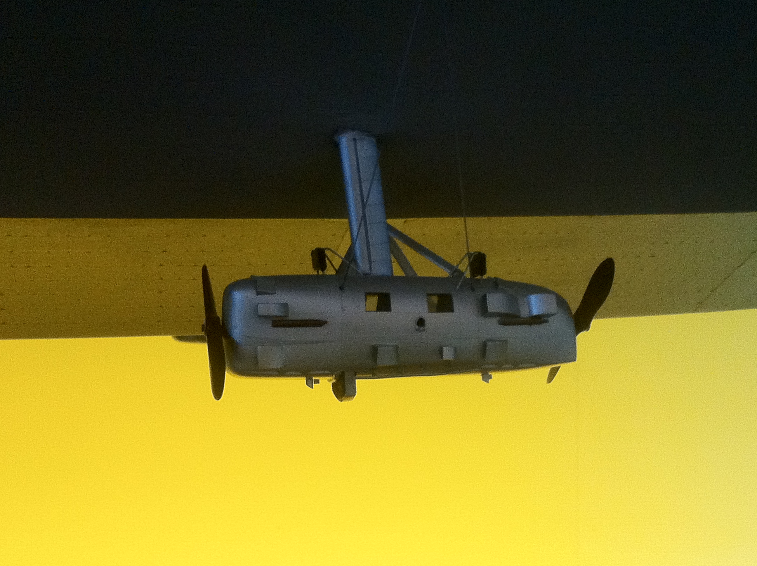
Close-up of one of the R100 engine gondolas that contained two V12 Rolls Royce engines (model Aviation and Space Museum)
Constructed of a lightweight aluminum rigid airframe and filled with hydrogen gasbags, the outer skin of the R100 was made of an aluminum dope coated linen. Completed in 1929, the R100 made a number of test flights before it was decided Her Majesty’s Airship would prove her airworthiness to the world by completing a trans-Atlantic journey to Canada in 1930. Two years earlier the Germans had successfully crossed the Atlantic to the United States in their Graf Zeppelin, and now it was Britain’s turn.
Size comparison showing how large the Zeppelins were compared to modern day jet airliners.
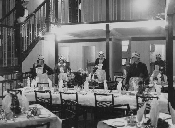
With a crew of 37 and a passenger capacity of 100 guests, accommodation was arranged on three decks inside the ship. The first decks were crew quarters, the second deck housed the dining room, which doubled as the passenger lounge, plus the kitchen, 18 four-berth passenger cabins and a gallery on either side for passengers to enjoy the view through the windows built into the skin. The third deck consisted of a gallery running around the dining-room and 14 two-berth cabins.
The R100 dining room and staff ready to make your Zeppelin voyage an enjoyable one.
The R100 control cabin and passenger decks above with ample windows. (model Aviation Museum)
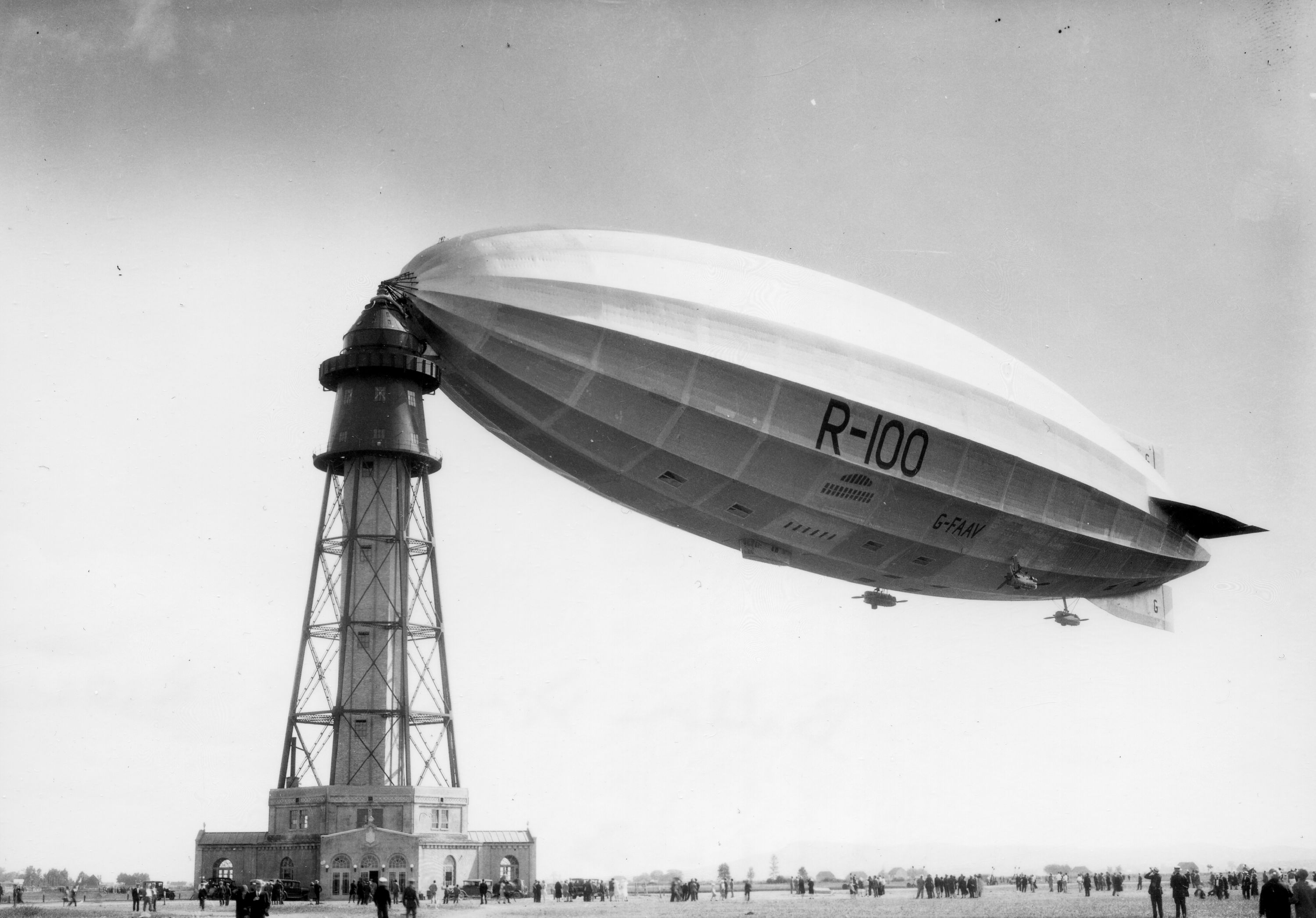
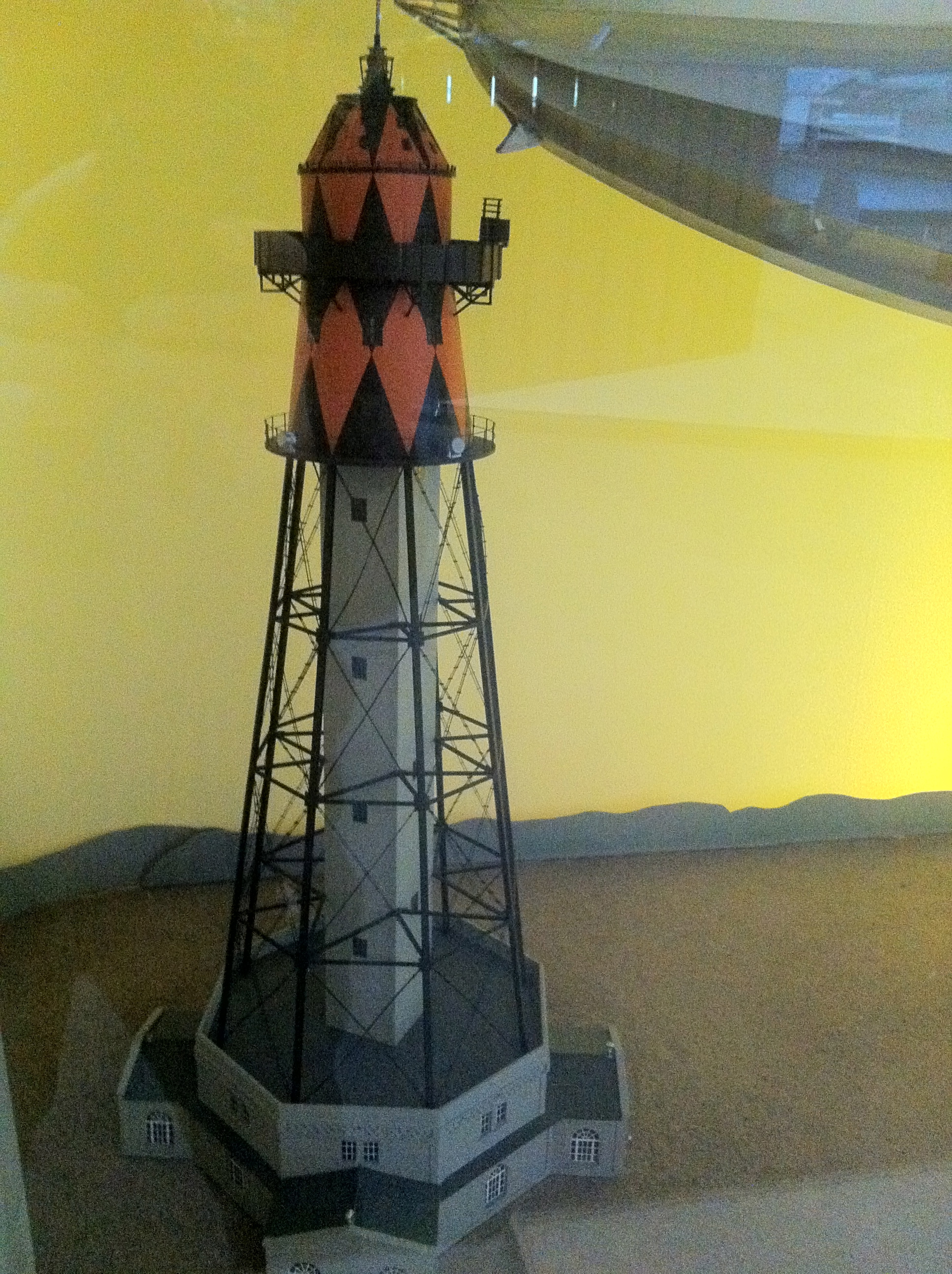
After leaving England on July 29 1930, the R100 successfully crossed the Atlantic and arrived in Montreal in just 78 hours at an average speed of 68kmh. A special mooring 200 foot Art Deco mast was built specifically for the giant airship’s arrival, the only one of its kind in the world outside of England. Docking at the new mooring mast at an airfield in St. Hubert, over 100,000 people a day rushed to view the future in Zeppelin transportation.
The specially built mooring mast tower for the R100 at St. Hubert airfield just outside Montreal.
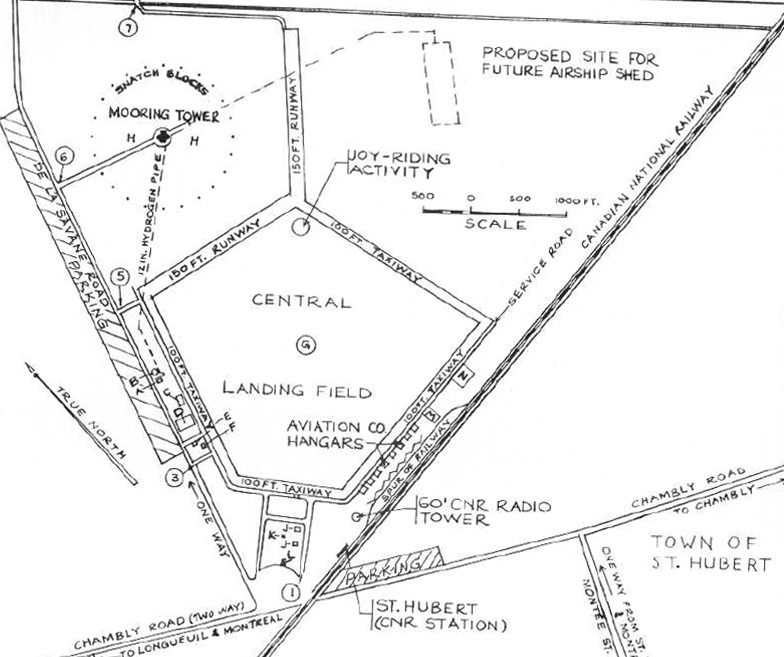
Original map showing the St. Hubert airfield with the location of the airship mooring mast and hopeful future hanger.
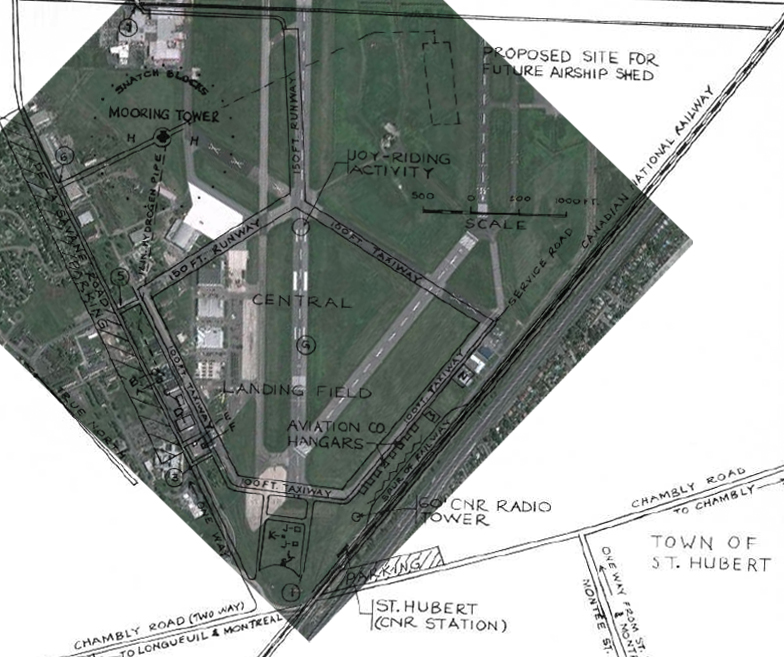
The same map overlaid on a current map of the St. Hubert airport. Note the tower has since been demolished.
Location as it looks today of where the airship mooring mast would have been located.
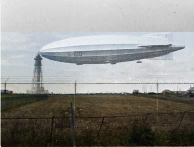
Long since destroyed, a composite image showing the R100 and the mooring tower ghosted over the same view today.
OVER OTTAWA
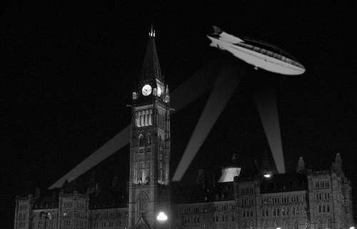
The majestic airship, three times the size of a modern 747 jet, soon left Montreal with VIPs from Ottawa and headed out for a 24 hour tour of Ontario. Departing Montreal the R100 sailed west and under a bright moon, hovering quietly over the Nation’s Capital, arriving at approximately 9:50pm. The entire city was swept up in “Zeppelin-mania”, with thousands rushing out of their homes, restaurants, and even abandoning cars in the middle of the streets to catch a glimpse of Her Majesty’s massive airship now over Ottawa. With the Peace Tower carillon playing “O Canada” and powerful searchlights targeting the R100 in the night sky, the R100 passed low over Parliament, The Chateau Laurier, and then sailed on towards Carleton Place and Smiths Falls. The age of the airship had arrived. (Sadly, no photos are readily available of this momentous visit to the Nation’s Capital due to the photographic technology of the time that limited proper night-time photography.)
Rendition of how the R100 may have looked hovering over the Parliament Buildings with searchlights on it as it passed over Ottawa August 10 1930.
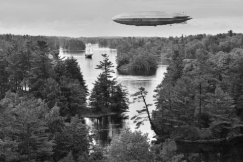
Continuing its silent passage through the night skies, the R100 reached Toronto at 5am the next day, passing over St. Catherine’s and even Niagara Falls. It made a brief appearance over the Thousand Islands and into New York State, before making the necessary preparations for a return to England.
Guests aboard the R100 would enjoy the finest in airship travel, as seen here in the lounge.
Rendition of how the R100 may have looked crossing over the Thousand Islands.
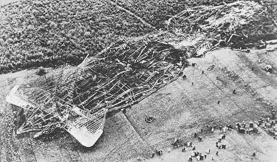
After a successful return flight across the Atlantic back to its base in Cardington, the British Air Ministry was confident their airships were ready to travel the world. The R100 had a sister ship the R101, that was outfitted with heavier, but safer diesel burning engines geared for tropical travel. Orders were given to send the R101 to India, to show the world they were the new Zeppelin masters of the world and that the Imperial Fleet was capable of reaching any destination they choose. Unfortunately, the hasty and over confident orders resulted in disaster. Just weeks after the R100 arrived safely back in England, the R101 left for India outfitted with its heavier diesel engines, but soon faced a violent storm over northern France and for reasons unknown, hit the ground, igniting its volatile hydrogen gas, exploding into a ball of flames killing 48 of the 54 people aboard. Humiliated and now unsure of the great Imperial Airship Fleet, the British Air Ministry ordered the remaining R100 grounded. After a year of contemplation it was decided the age of the airship was over for the British Empire, and in 1931, the once majestic symbol of a new era in aeronautics was pulled from her hanger in Cardington into a field where it was unceremoniously destroyed, flattened by a steam roller into a pile of aluminum that was later sold for the scrap metal value of around $1,200.
The R101 destroyed after its fiery crash in France just weeks after the R100’s successful voyage to Canada.
Hoping other countries like Germany and the United States would bring their continuing airship programs to Montreal, the St. Hubert airfield maintained their Art Deco mooring mast, expecting one day a visiting airship would once again return. No other airship ever returned to Canadian skies, and now just a sad reminder of a once romantic period in aeronautics, the airport demolished the 200 foot tower in 1938, bringing an end to the age of the airship in Canada.
The 200 foot Art Deco designed airship mooring tower in St. Hubert, Quebec, demolished in 1938 (model Aviation Museum)
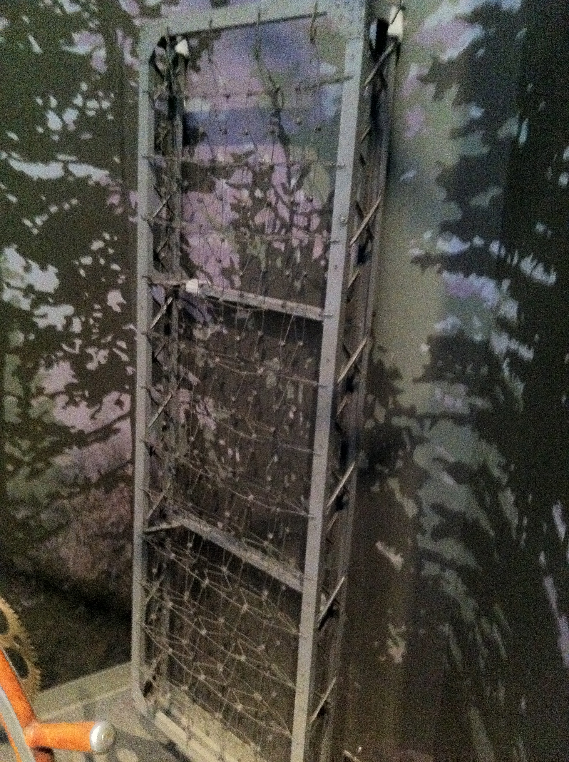
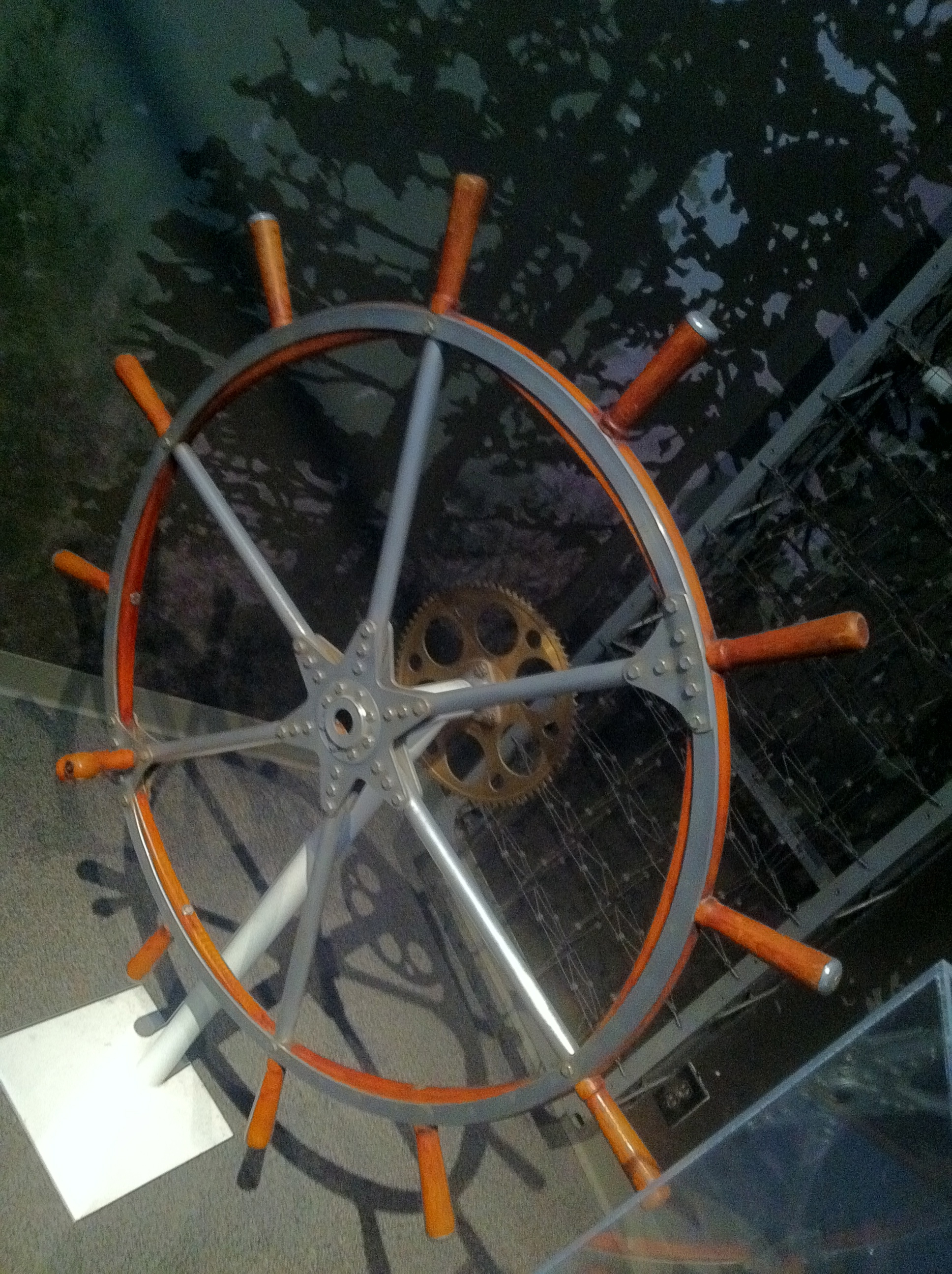
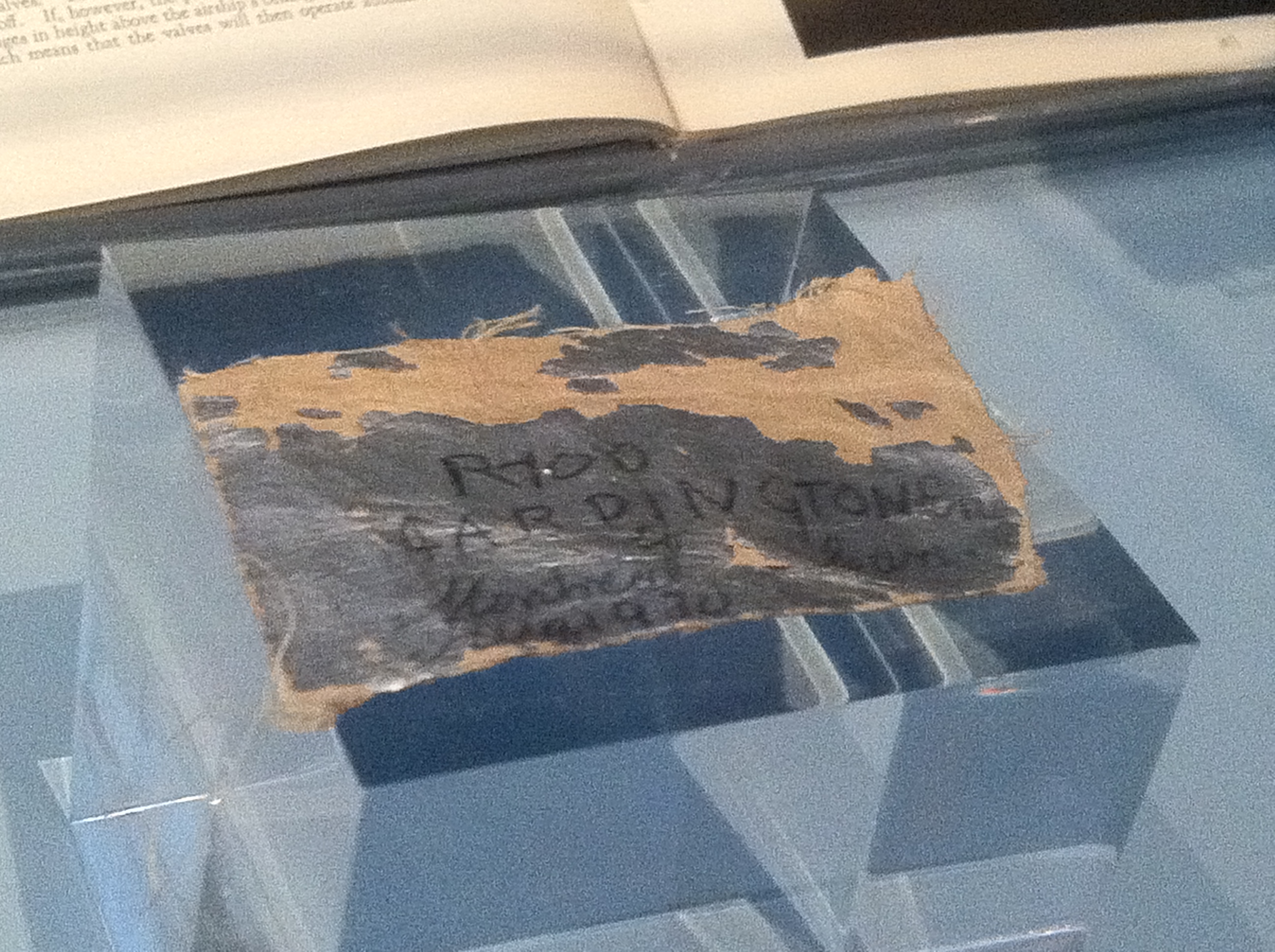
All that remains of the R100 today are few items on display in the Aviation & Space Museum in Ottawa, including the original control steering wheel, a bed frame, and a fragment of its outer linen covering. Some other components and the original airship hangers remain in Cardington, England.
A lightweight aluminium bed frame from the R100 airship on display at the Aviation Museum.
One of the original R100 control steering wheels on display at the Aviation Museum.
Fragment of linen covering from the R100 at the Aviation Museum.
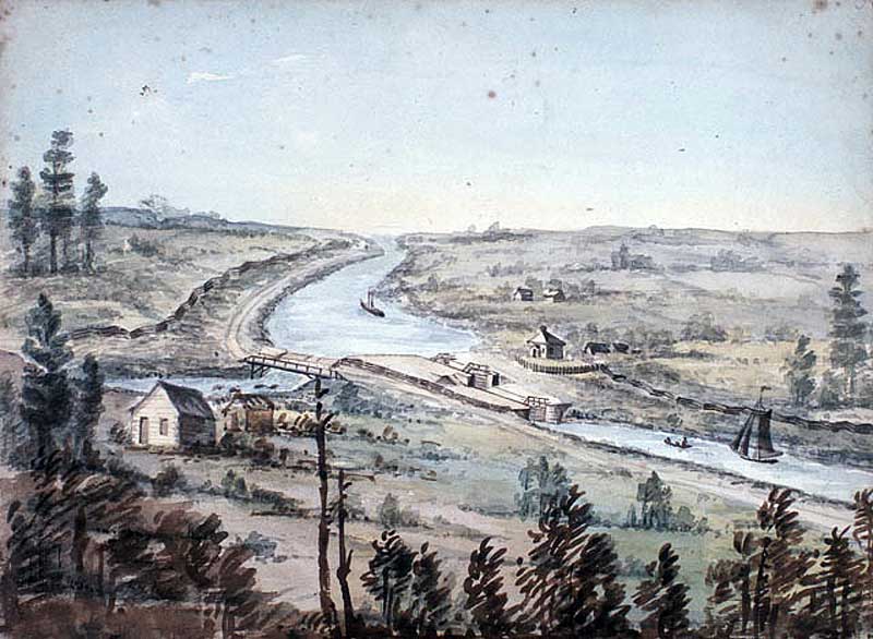
A sketch of Hartwells Locks as it may have appeared in 1845.
The Lost Silver Of Hartwells Locks
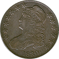
A Yankee Silver Half Dollar used to pay labourers of the Rideau Canal. Current value of a single coin is $200-600
During the construction of the Rideau Canal from Ottawa to Kingston in 1826-1832, thousands of workers employed by the British to build this massive feat of engineering were paid in Yankee Silver Half Dollars, part of the war indemnity paid by the United States to Great Britain after the War of 1812. This money was sent to the canal district in kegs from Montreal.
These vast amounts of silver coins were transported in barrels to paymasters cabins along the canal route, one being at Jones Falls, another at Smiths Falls, and another one at Hartwells Locks. Hartwells Locks lies just on the southern end of Dow’s Lake in Ottawa near Carleton University.
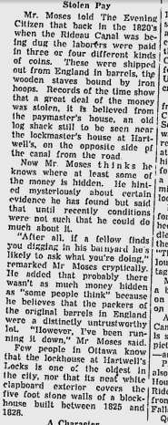
The paymasters cabins were storage facilities and dispensaries for wages, and due to some “untrustworthy” men among the ranks of the paymasters and those that delivered the silver, coins mysteriously vanished and were apparently buried to be recovered later by the persons who hid them. This legend was substantiated by a retiring Hartwells lockmaster in 1953, Alan Moses, who claimed “a great deal of money was stolen from the paymasters house, an old log cabin across the canal from the lockmasters house”.
Article from a 1956 Ottawa Citizen outlining the legend of the buried silver at Hartwells Locks
He claimed he was going to find the lost silver after his retirement from the locks. No one knows if he ever found the silver or if it lies there still waiting to be discovered. Currently a single Yankee Half Dollar from the 1820s is worth about $200-$600 and contains 90% pure silver.
A sketch of Hartwells Locks from 1845 showing the paymaster cabins in the foreground, across the canal from the lockmaster’s house.
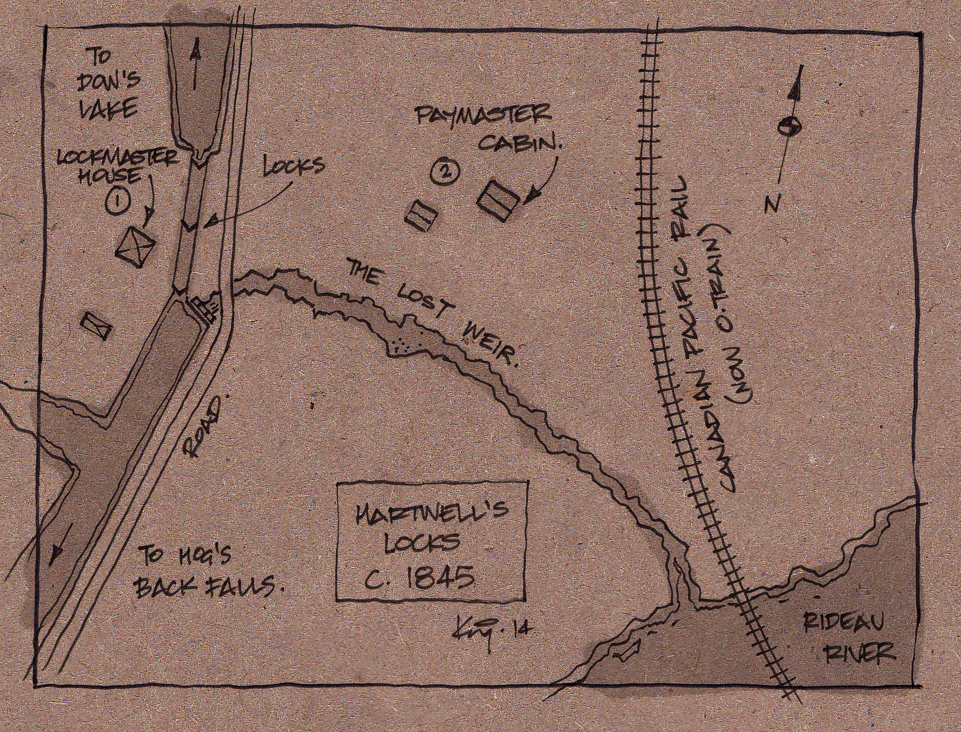
Using an old sketch painting of the area from 1845 that shows the lockmasters house and the paymaster cabins, I was able to sketch out how the area may have looked in 1845 compared to a present day Bing Maps aerial image. You can see where the Paymaster cabins would have been and what is there now. It seems the Engineering Buildings of the University have since covered the area and a new building has been constructed nearby. It is unclear if any archeological discoveries were made during the excavation of these buildings.
Composite map of Hartwells area showing the original paymaster cabins and what is there now.
The Lockmaster’s house, which still stands at Hartwells Locks, is one of the oldest buildings in Ottawa and is a concealed fortress structure. Built around 1826 when the canal started construction, this two story building was made out of stone as a defensive structure to protect the locks in case of attack. The stone fort was later covered in clapboard siding to protect it from the elements and is how it looks today.
Original stone Lockmaster’s House now covered in clapboard siding.
Along with the tales of the buried silver dollars and a concealed stone fort, Hartwells Locks also had a bywash to carry overflow water to the Rideau River across what is now Carleton University. Originally built as a weir to carry water out of the locks during operation, the channel was an open creek that cut across the land to the east of the locks and emptied into the nearby river.
Map sketch of the area in 1845. Note bywash weir.
“Ghost” map showing the original 1845 map and a current aerial map.
A sluice gate was used at the side of the locks that regulated the weir waters, and is still visible to this day. The open weir was still in operation into the 1950s but was later adapted to run underground and diverted with culverts when the campus of Carleton University took over and developed the land in the early 1960s.
Original sluice gate as it looks today that connects to the now underground weir.
Does the lost silver of Hartwells locks still lie underground waiting to be uncovered or did the retired lockmaster find it and quietly retire to a villa in the Bahamas with what he found? Whatever the case, there is still the concealed stone fort and an underground channel that remains a hidden reminder of the fascinating canal history of the area known as Hartwells Locks.