history

MAYHEM OVER MANOTICK

THE TRAGIC CRASH OF A WW-2 BOMBER IN A MANOTICK FARM FIELD

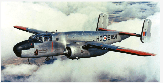
After World War Two ended in 1945, many of the aircraft that were in service moved on to other roles in the 1950s. This included the North American B-25 Mitchell, an American medium bomber that was introduced in 1941 and used by many Allied air forces during the war. The B-25 served in every theatre of World War II, and many remained in service in the post-war period.

A B-25J similar to the one that exploded over Manotick in 1957. (SilverHawk.com)

One such B-25 was number 5215 in service with the Central Experimental and Proving Establishment, or CEPE, which was formed in 1951 by amalgamating Ottawa operations at Rockcliffe, the Winter Experimental Establishment in Edmonton, and the R.C.A.F. (National Research Council) Unit in Arnprior. Headquarters of CEPE were at Rockcliffe in Ottawa, with detachments at several sites across Canada. In 1957 CEPE was moved to RCAF Station Uplands also in Ottawa, a move necessitated by the longer runways required for testing new jet aircraft.

A B-25 at Rockcliffe Air base in Ottawa. (SilverHawk.com)

The CEPE tested captured German rocket planes like the Messerschmitt 163 KOMET in Arnprior which was covered in a previous article here. It would be in the same year that the CEPE was moved to Uplands that a tragic and still unsolved crash killed 8 people aboard the B-25J in Manotick, Ontario.

A B-25 in RCAF service like the one that crashed in Manotick. (SilverHawk.com)

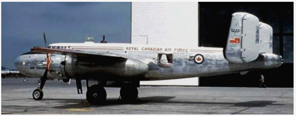
On March 1st, 1957 B-25J 5215 that had been modified to carry passengers instead bombs was completing a flight from Churchill, Manitoba to Ottawa with a fuel stop in North Bay, ON. Previously, the aircraft was part of the United States Air Force, built in 1944 during World War 2 with serial number 44-30485. Received from the USAF at Mobile, Alabama it went into storage with Training Command at RCAF Station Saskatoon, Saskatchewan in December of 1951. It then went to Advanced Flying School
at Saskatoon in January 1952, then to North West Industries in Edmonton, Alberta for modifications in 1952/53. The modifications made included avionics upgrades but there is no mention of engine modifications that may have led to its demise.

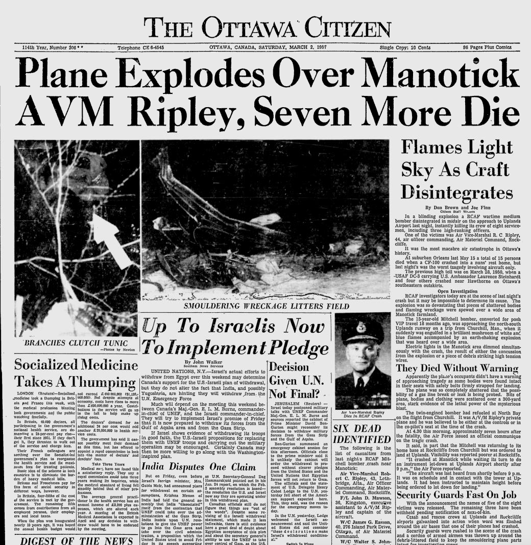
With bad weather engulfing the Ottawa area that night, the B-25 was advised to land at Uplands instead of Rockcliffe. As the plane made its descent to land at Uplands, it suddenly and unexpectedly exploded in mid-air, with a blinding white light flashing over the small village of Manotick southwest of Uplands airfield.

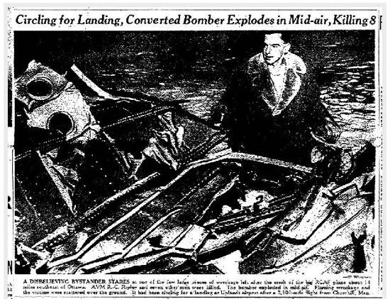
Witnesses in Manotick said that the plane was sputtering and then in blinding flash, exploded in mid-air, hurtling to the ground and exploding in a second fireball that rained aircraft fragments throughout the farm field where the tragedy occurred. Eight people aboard died that fateful night in 1957, including Air Vice Marshal Robert Ripley, Commander of the Air Material Command. Also lost that night in the explosion were:

RCAF Leading Aircraftman Kenneth Oliver Doerksen
RCAF Wing Commander James Garvin Easson DFC
RCAF Corporal Ronald Wesley Faulkner
RCAF Leading Aircraftman Joseph Maurice Gauthier
RCAF Wing Commander Walter Sherwood Johnson
RCAF Flight Lieutenant John Douglas Mawson DFC

Lt. Commander Henry F. Utting, Naval Testing Detachment

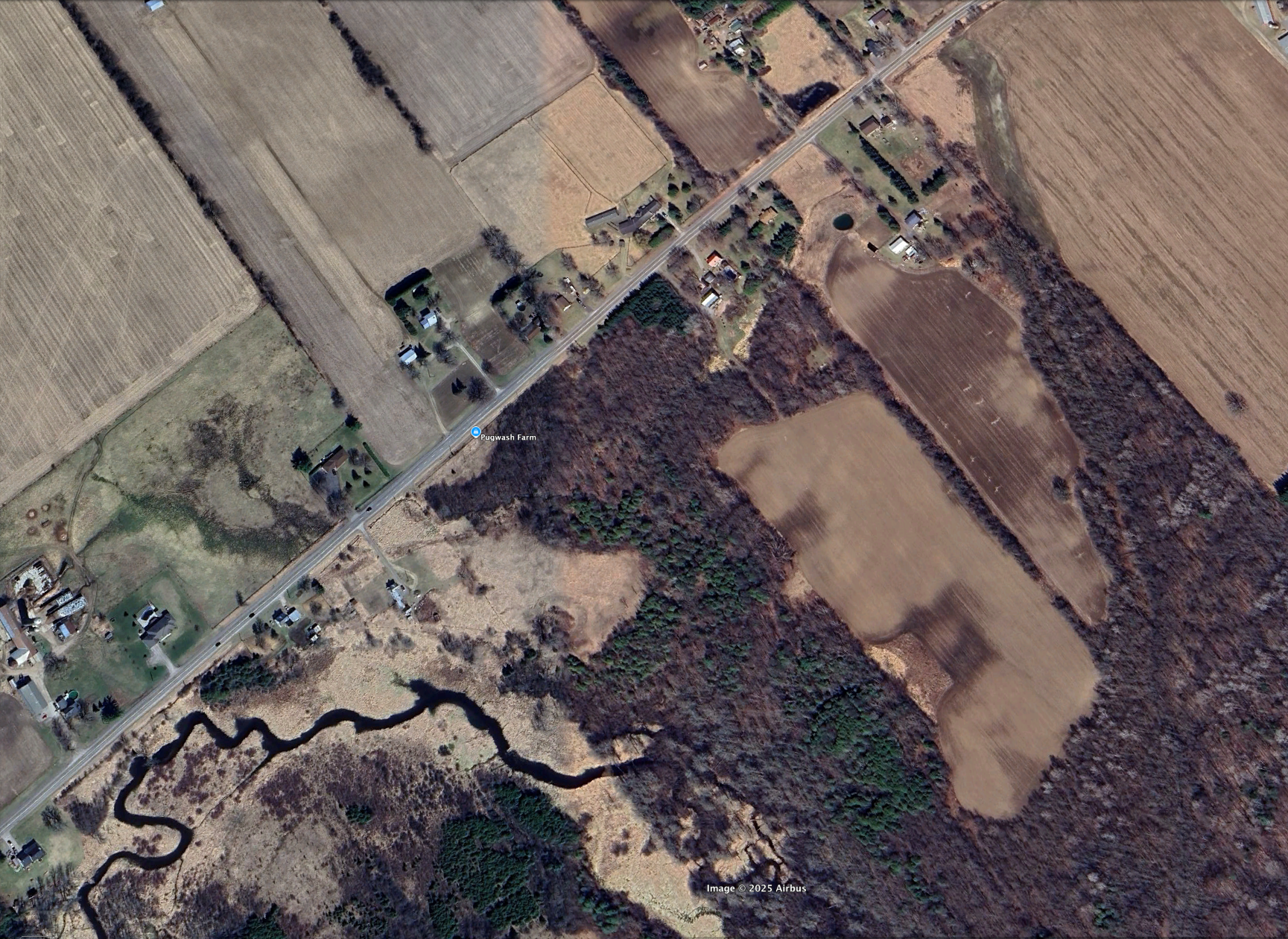
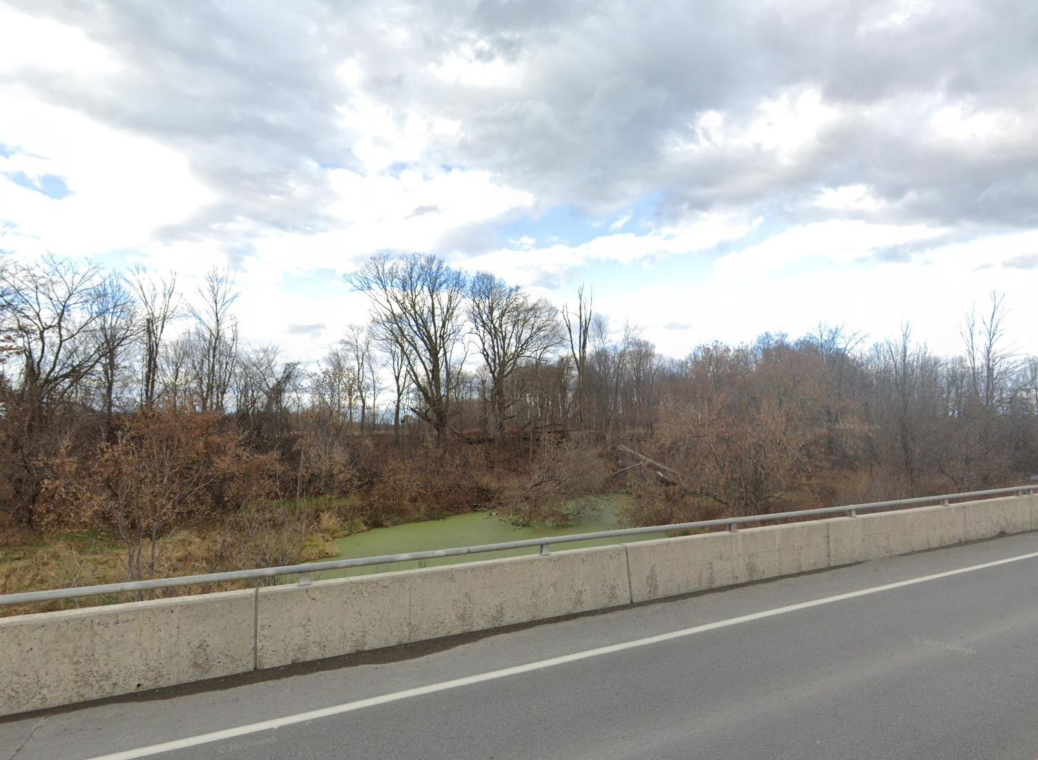
The aircraft explosion sent wreckage across the farm field of Thomas Watts, whose field was on Bankfield Road across from the Rona that is there now. The violent force of the explosion sent parts flying into the powerlines of Manotick causing a brief power outage, but of the utmost macabre was the fact that the body parts of the crew members were found all throughout the farm field and in the trees along the nearby creek.

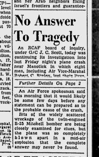
The flaming wreckage set fire to the trees and soon RCAF officials arrived to contain the chaotic scene. Plane parts were imbedded into tree trunks, the creek bed strewn with wreckage. Investigators into the crash could not determine the cause of the tragic explosion, and it is not known to this day why it exploded into a ball of white light on approach to Uplands Air Base.

WHAT’S LEFT?

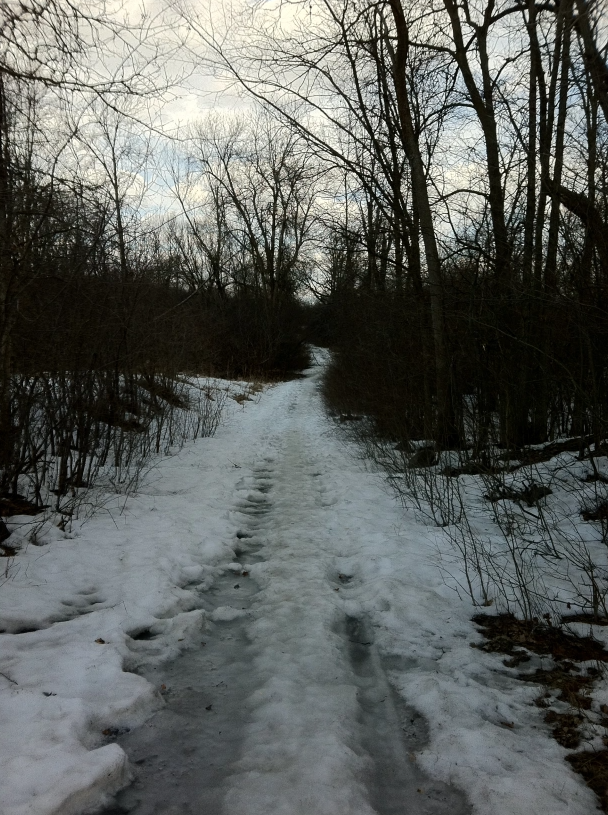
Sixty eight years after the tragedy, nothing marks the spot where eight men lost their lives, no plaque or any indication of what exploded over Bankfield Road that fateful night. A quick Google Maps search reveals the exact location of the crash site, but does anything remain from the B-25 bomber in the ground or in the creek where it happened?

The location of the 1957 B-25 crash site. (Apple Maps)

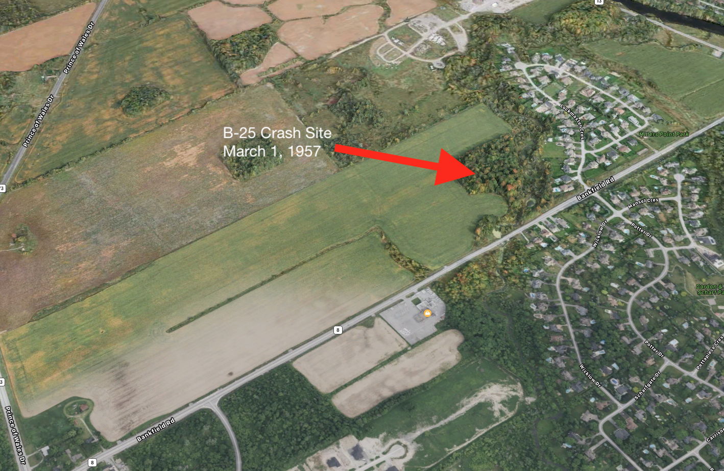
A search and sweep with a metal dectector might turn up pieces of the plane and other relics of this lost aircraft. A quick walk around the site definitely provided an assessment of the dense wooded area and creek where the aircraft wreckage was said to have crashed.

The crash site off Bankfield Rd. near Manotick.

FURTHER INVESTIGATION

Without permission from the land owner whose property may contain lost wreckage from the B-25 bomber, it will be difficult to venture forth with a metal detector to see what, if anything, lies buried in the ground from this crash. With the 70th anniversary of the tragic incident approaching in 2027, it might be time to now pursue possible further investigation, or at least get the ball rolling on a commemorative plaque possibly being placed nearby as a memorial to the eight souls that perished that terrible night in 1957.

The B-25J currently in flying condition with the Canadian Warplane Heritage.

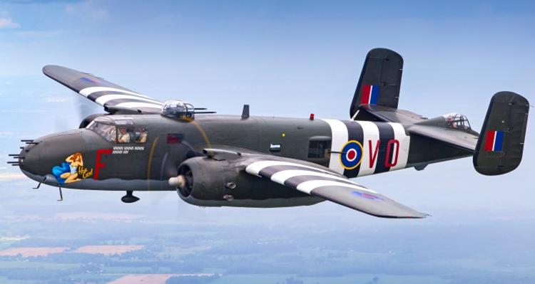
I would like to call upon the City Of Ottawa, the RCAF, The Local Manotick Brach of the Legion and maybe the Canada Air and Space Museum to assist in an investigation to recover and respectfully remember the B-25 crew lost that night. I would also like to advise the Canadian Warplane Heritage Museum that operates a flying condition B-25J to possibly consider doing a commemorative flypast over the site in 2027 to mark the 70th anniversary of what I would call the….Mayhem Over Manotick.

Andrew King, April 2025

SOURCES:

https://asn.flightsafety.org/wikibase/170117

https://www.veterans.gc.ca/en/remembrance/memorials/canadian-virtual-war-memorial/detail/80002496?Robert%20Campbell%20Ripley

https://caspir.warplane.com/personnel/unit-search/p/600017105

https://www.silverhawkauthor.com/post/canadian-warplanes-3-north-american-b-25-mitchell

GOOGLE MAPS

AN ANCIENT SOLSTICE MONUMENT SOUTH OF OTTAWA?

The year is 1854 and eight years prior, The Smithsonian Institution was formed in 1846 as a group of museums, education and research centres, created by the U.S. government “for the increase and diffusion of knowledge”. It still operates as a trust instrumentality and is not formally a part of any of the three branches of the federal government.

The Smithsonian Institution “Castle” built in 1849.

A representative from the Smithsonian, a Mr. Guest is sent to Canada, specifically Prescott, Ontario to investigate what seems to be a large earthworks formation resembling an ancient fort. Mr. Guest arrives from Ogdensburg, NY. He describes the first site as being “eight miles and a half northwest of Prescott” and containing “mounds and embankments.” He then mentions the presence of four mounds arranged in a rectangle formation, which contain between one and two acres of ground. He says the mounds were up to four feet high. Guest sketched the formation:

Mr. Guest’s 1854 map sketch of the formation.

Guest’s map shows what he describes as “a half moon embankment, extending some ten rods across a neck of land, terminating to the north in a swamp, and to the southwest near the edge of a creek. It has three openings, which are from twenty to twenty-five feet wide.

Guest believes the entire “island” of land was artificially constructed out of sand and notices charcoal and ashes; and human bones, pointed bones from the leg of the deer, horns and skulls of the same animals, human skulls and bones of the beaver” as well as: A walrus tooth pendant. Curious, because the Prescott area is not known for its walruses…

A Walrus Tooth Pendant, similar to the one found by Mr. Guest.

So where exactly is this earthworks formation that the Smithsonian sent Mr.Guest to investigate in 1854? Well, taking the distance Guest mentioned of 8.5miles NW of Prescott, we can set up a general vicinity.

The general area that Guest describes northwest of Prescott.

This is remarkably close to another curious site that turned up an unusual European made 15th-16th century bone needle case back in a 1912 archeological dig.

A machined bone needle case of European manufacture found near this site in 1912. (Canadian Museum of History)

I was able to access the LiDar imagery data of that particular area and transform the map to a surface detail map to see what kind of topography exists and if anything resembles the “island fort” Guest discovered.


Studying that area Lidar imagery it appears we have a very close match to Guest’s 1854 investigation map, although a modern road has been constructed through its western arm:

To confirm this was the site investigated by Guest, I overlaid a ghost image of the fortress sketch on top of the Lidar image… It’s a pretty good match…

Ok, so we have some kind of earthworks here to investigate…I am familiar with this site, having been introduced to an unusual archeological find here discovered in 1912. An archeologist by the name of Mr. Wintemberg discovered a piece of “carved bone,” that he described as “suspiciously European.” This suspiciously Out Of Place Artifact was then stored away in the Museum of History warehouse where its origin remained a mystery…and its research data has since been removed from the museum database.

Luckily I don’t rely on the Internet for everything and I have acquired the original 1912 archeological report:

And using this report we can get a sense of where and what was found here… Burials. Objects. I can even trace back to 1912 photographs of the site and the massive excavation of this earthworks…

Objects recovered in the 1912 archeological dig. (Wintemberg report)


So what was this unusual structure and who built it? It seems the 1912 report doesn’t really know, but attributes it to the St.Lawrence Iroquois. “AGE OF THE SITE The age of the site is unknown and there is no positive evidence pointing to its great antiquity”

Site excavations in 1912. (Museum of History)

I saved the recent report about the European bone needle case found there in 1912, which states that according to former Curator of Central Archaeology at the Canadian Museum of History, Jean-Luc Pilon, the curious bone object was studied in detail and using a small sample taken from the odd cylindrical object & was carbon dated with an accelerator and mass spectrometer. The final results of the dating put the oddity at a date of between 1499 and 1578…and was determined to be a European machine lathed bone needle case for metal sewing needles. Wait, how did a European lathed bone metal needle case get into these earthworks far before Europeans were in the area?

Screenshot of Museum Of History website catalogue.

One answer could be that the object was traded between tribes and made its way from the East Coast of North America in the 1500s all the way to this site south of Ottawa. Another theory is that a new European visitor made their way to the site, maybe a lost a castaway from a European expedition, or perhaps an expeditionary group using smaller boats came into the area and left behind objects of their making. The object was found among other dated Iroquois objects of the time which ruled out it was dropped there at a later time. Whatever the “case” may be, literally and figuratively, this object is truly an Out Of Place Artifact, as the indigenous people of that time had neither lathes or metal needles.

Further examination of the Lidar imagery shows that the original earthworks formation studied by the Smithsonian’s representative, Mr. Guest has been partially destroyed. (Note the crater at bottom) Perhaps from the 1912 excavation?

ANCIENT EARTHWORKS A CELESTIAL OBSERVATION STRUCTURE?

Was this structure an Archaeoastronomical Complex…?

The unusual layout and odd diagonal embankments reminded me of other ancient structures aligned with the Spring Equinox and Summer Solstice…like the ancient mounds in Ohio and the Serpent Mounds. I applied the Sun Surveyor app to the structure and it seems to lean in that direction. The embankments of lines in straight and diagonal positions seem to align with the Spring Equinox and Solstice Sunrise…the circular mounds as observation points.

Screenshot

To analyze the data for further confirmation I made an input of the data to Ai Grok to make an analysis. Seems the theory is correct:

So, it seems that there is an ancient earthworks that was built south of Ottawa that was specifically designed and built to recognize celestial alignments on the equinox and solstice. Grok Ai analysis thinks this warrants further archeological investigation.

The Ai analysis seems to confirm that the structure was some kind of Celestial Alignment structure that corresponds to the Spring Equinox and Summer Solstice Sunrise.

The structure alignments.

Whatever the case may be here, there was a highly unusual earthworks formation, made by either ancient Hopewell Mound Builders, or advanced St.Lawrence Iroquois even though they were not known for mound building practices. So who built it? The Ancient Hopewell Mound people of the Adena culture? A local history mystery that deserves further investigation…

Will anyone in the Canadian Govt or its agencies take notice? Will it be ignored and forgotten? Likely, but this is why I am making a record of this data and information to record it for any future prospects. Perhaps someone somewhere will take an interest in what I think was an unusual ancient mound structure that was likely built to observe key moments in our celestial calendar.

Andrew King, March 2025

My thanks to Shane for the map & tip, the Smithsonian, the Govt Of Canada Lidar Mapping, the Museum of History. And Google Maps.

THE WRIGHT STUFF: On the 225th Anniversary, Finding The First Permanent House in Canada’s Capital Region…(gasp! built by an American?!)

There is no replica structure, no plaque, not even a flagpole or an engraved rock. It does not appear on current maps and has been omitted from the tour books. Yet, for such an important historical marker in the National Capital’s history, you would think they would put *something* to mark the spot the first permanently constructed home in the Capital Region. The first to build a cabin in this area’s wilderness, the first to farm the land, the first to essentially build and pave the way for what would become the National Capital Region of Canada. As we approach the 225th Anniversary of this intrepid adventurer’s arrival and construction of the first house, nothing will likely be mentioned elsewhere, so I thought it would be fun to find out where exactly this pioneer homestead would have been. Maybe then those that pass by it will appreciate the history that lies before them. Perhaps this odd elusiveness of recognition is because this first homesteader was neither French, nor British, but an AMERICAN and the shame is too great to admit. His name was Philomen Wright and this is the quest to find his home from 225 years ago.

The American Philomen Wright and his wife, Abigail, who built the first permanent home in the National Capital Region in 1800

The first to arrive in the Ottawa region 225 years ago came to an area inhabited by nomadic native Algonquin tribes for centuries without any known permanent structures, a land that was a clean and fresh piece of Canadian wilderness. This person was Philemon Wright who was an American from Woburn, Massachusetts and dreamed of leaving the Boston outskirts for a new land, to create a prosperous new life in a fresh, untouched part of the continent. That part of the continent was the the unsettled land we now know as Ottawa/Hull, a land that was being divided and given to men who would turn it into the National Capital Region. Having fought against the British during the American Revolution just a few years earlier in 1776, Wright knew it would not be an easy task to secure his new land now under British control.

Lucky enough for Wright, British authorities at the time were seeking to populate the vast new lands of their colonies. They arranged a program to have group settlements in the wilds of Canada. Interim land grants were given to leaders and associates, then the associates would hand over portions of their land grants to the leader as payment to the leader who did the exploration and surveying. One of these leaders was Philemon Wright, who visited Lower Canada often, specifically the area of Ottawa/Hull. After numerous visits to this area in the late 1700s, he applied for a land grant to the British Empire. They approved his grant for a land settlement in this barren land under one condition: Every adult male in his settlement must swear an oath of allegiance to the His Majesty, the King of the British Empire.

He convinced a number of his Boston neighbours and family members to sign over their land grants to him, and join him as “associates” on a journey north to settle a land no other European descendent had settled. So with 50 men, women and children, labourers and axemen, Wright set off in horse-drawn sleighs in February of 1800 for Montreal. Arriving in Montreal in March of 1800, Wright and his men swore allegiance to the King Of England and received their land grant for an area where three rivers met, the Ottawa, the Rideau and the Gatineau. His land grant and home was to become what is now Lac Leamy Park.

The land Philomen Wright settled on to build his cabin and future lumber empire…from an 1855 painting.

Traversing the frozen waters of the Ottawa River in March of 1800, Wright and his settlers arrived on the shores of the Gatineau with the aid of an Algonquin guide, who showed them safely to their new land. Philemon and his crew climbed up the embankment 20 feet from the shore and began to clear the area of trees, using felled logs to construct what would become the very first permanent home in the National Capital Region. 

Wright’s account of his arrival written 20yrs after, in 1820. Ottawa Public Library special collection.

Wright had soon cleared the land and built a farm, and also built a road to the thundering and raw Chaudiere Falls where he built the first mill and began a logging empire that continued for over a century. After his empire began to blossom, Wright moved from his simple log cabin to a new home he built in Wrightstown, the town named after him that sprung up around his mill at Chaudiere Falls that would later become Hull, Quebec. In 1835 he sold his original cabin and farm, which he called Columbia Farm, to Andrew Leamy, which the area and lake are currently named after.

FINDING THE ORIGINAL CABIN

So now that we know the rough area where Wright landed and built his log cabin, what is left, if anything, of this original settlement?  The original Wright farm road, which led from his original log house to his prosperous mill over by Chaudiere Falls partially remains, but where was the original cabin?

I walked down what would be the Ottawa Valley’s oldest road to see what I could find out…

The oldest road in the Ottawa Valley built 225 years ago by Philomen Wright in 1800 still exists.

Looking at old maps from the Ottawa Public Library, Wright’s personal memoirs of the first settlement, and researching various NCC and historical information about the area, we can put together a pretty good picture of where it might be.

The Wright family called that home “The Wigwam”, and it is referenced numerous times in many historical accounts. The house itself was built as Wright says in his memoirs that I found at the Ottawa Public Libray:

“…built of undressed tamarac logs in true rustic shanty fashion. The chinks between the logs and scoops of the roof were caulked with moss, driven in with a thin pointed handspike, over which a rude plaster of blue clay was daubed. The chimney was very wide and low, and was built above a huge boulder which formed the back of the fireplace. There was no upper story to the rude dwelling, which was partitioned off into bedrooms at each end, with a large living room, kitchen, dining room all in one, in the centre.”

A similar, American style log cabin from 1800 that likely would have resembled Wright’s original homestead.

Searching the database from the Library and Archives of Canada, an old map from 1884 shows the lands owned by Wright and some buildings marked on it, including something called “Old House”. (MIKAN Item number
4133993)

I would assume this “old house” in 1884 was the original Wright cabin from 84 years prior, as the later Leamy residence is marked on the same map further north of this structure. Using this as a focal target point, I can then import that map and overlay it on a modern Google Map to pinpoint the exact location of the 225 year old cabin.

Ghosting the 1884 map over the current Google Map we can see where the cabin would have been located and go to Streetview level to investigate what is there…and absolutely nothing. Buried under a metre of snow right now in February of 2025, a visit to the site would turn up nothing, so we will have to wait til spring to see what remains, if anything. Unfortunately it looks like they paved a bike path right over the spot where Wright’s original cabin home would have been, potentially sealing up any remains beneath it.

The location of Wright’s original 1800 cabin is devoid of any indication of its past presence there..just a paved bike path now…(Google Maps)

Perhaps the large boulder used as the fireplace mentioned in Wright’s account still remains at the site…or is that now the boulder that now rests in front of Philomen Wright Highschool? Anyone know?

Is the boulder in front of Philomen Wright High School the same boulder he mentioned in his account of building the cabin fireplace?

Will the NCC (National Capital Commision) that owns the land ever recognize this spot with a commemorative plaque on the 225th anniversary of the founding of the very place the agency is named after? Maybe a replica cabin? Something?

AMERICAN PRIDE

Despite the Canadian lack of recognition, it seems the Americans went full out with their commemoration of Philomen Wright’s founding of Canada’s Capital Region. In fact, back in 1980, the NCC and US State representatives erected what was the largest free-standing cast plaque in North America commemorating Wright’s settlement on the site of Wright’s original home….IN MASSACHUSETTS.

The Americans with their NCC partnered plaque no where near the site but rather in Wright’s hometown of Woburn, MA.

I found the final resting place of the founder of Canada’s Capital Region who lies buried in a simple grave a few kilometres away from where he originally landed 225 years ago. For whatever reason there is no marker or indication of where Wright built the first permanent home in the NCR, perhaps because he happened to be an American who would create the cradle of Canada’s Capital.

It seems sad to stand on the spot where a man worked so hard to create a life for himself with nothing there to commemorate his efforts. It remains ignored and forgotten, but I would like to think that the legacy of Wright and his cabin, the first of its kind in the Ottawa Valley, will one day be recognized for its historical importance and a place for all of us to visit, enjoy, and reflect upon in the years to come.

Andrew King, February 2025

SOURCES

“Account Of The First Settlement Of The Township Of Hull, On The Ottawa River, Lower Canada”. By Philemon Wright, 1820. Ottawa Public Library.

http://en.wikipedia.org/wiki/Philemon_Wright

http://en.wikipedia.org/wiki/Andrew_Leamy

http://www.westquebecers.ca/?action=show&lid=11D7E-GQVKL-29AZ7&mid=32

http://www.gvhs.ca/publications/utga-memorial.html

http://www.ncc-ccn.gc.ca/property-management/what-we-manage/archaeological-investigations-ncc-lands

http://www.bytown.net/wrightpm.htm

Google Maps

McRelic: Ottawa McDonald’s Sign The Oldest In Canada?

The McDonald’s sign in Bells Corners could be the only original surviving example in Canada. (Google Streetview)

As the capital city of Canada, Ottawa contains a number of historical artifacts, and it may contain a historical relic beyond the scope of museums: The Oldest Original McDonald’s sign in Canada.

BACKSTORY

Back in the 1980s I visited my aunt in Kanata and we would often visit Bells Corners and pass by a McDonald’s that always seemed like a magical wonderland with its colourful Party Caboose and its huge Golden Arches. I never thought much about it until recently when I was passing by it reminiscing about the carefree times as a kid in the 80s and noticed something unusual about it. The Golden Arches seem to grow right out of the ground, unlike any other McDonald’s sign I’ve ever seen. This took me on a assignment to uncover why it was so different, with the result being that this could very well be the oldest surviving McDonald’s sign in Canada.

History Of McDonald’s In Canada

Canada’s first McDonald’s in Richmond BC opened in 1967. Note the “Big M” sign. (City of Richmond Archives Photograph 1987 61 3.)

In 1940 Richard and Maurice McDonald opened the first McDonald’s in San Bernardino, California and by 1961, McDonald’s filed for a U.S. trademark on the name “McDonald’s”. Under the guidance of Ray Kroc, they filed for a trademark on a new logo—an overlapping, double-arched “M” symbol. Although the “Golden Arches” logo appeared in various forms, the present version was not used until November 18, 1968, when the company was granted a U.S. trademark.

The 1968 Golden Arches logo design.

In Canada, the first McDonald’s opened in Richmond, British Columbia in 1967 by future Keg founder George Tidball. A year later in 1968 the first McDonald’s in Ontario opened at 520 Oxford Street West in London.

The first McDonald’s in Ontario, opened in in London in 1968. The original building exists, but the sign is the later 1970s pedestal sign.

George Cohon headed an operation of opening other franchises in Eastern Ontario, notably at 344 Queen Street East in Brampton, which was the first in the Greater Toronto Area. In 1971, Western and Eastern Canada operations merged to create McDonald’s Canada with Cohon in charge.

The first McDonald’s to open in the Toronto area, in Brampton. Sign is later pedestal type.

It would thus be in the years of 1968-71 that we would start seeing the “Big M”, a massive golden-arch sign design used until the mid-1970s when it was replaced with the now familiar, and still used, smaller McDonald’s sign attached to a towering pole.

“The Big M” sign design used from the 1960s to the mid 1970s.

This later 1970s sign was part of a new “look” promoting the mansard-roofed, brick-covered restaurants of that era we all knew and loved as kids in the 80s.

The “new look” McDonald’s of the 1970s with the brown brick, mansard roof and pedestal sign.

Surviving examples of the original Big M sign are increasingly rare, with only a handful still surviving in the United States, and as far as I can determine, only two exist in Canada…a restored new version at the first McDonald’s in Canada, and the one in Bells Corners.

THE SIGN

The Bells Corners McDonald’s sign is original to the restaurant that likely opened in 1970/1 as determined by an old Ottawa Citizen ad from June 4, 1971.

The Bells Corners McDonald’s sign as seen in the 1970s. Note “Hamburgers” on the sign.
An ad in the Ottawa Citizen from 1971 showing 4 locations.
The new Bells Corners McDonald’s mentioned in 1971.

That location joined three other “first” Ottawa McDonald’s that opened around the same time.

-1880 Carling Avenue (store still exists, has later pedestal sign)

McDonald’s at 1880 Carling with the later 70s pedestal sign.


-622 St. Joseph Bld. Hull (non-existent)
-1675 Merivale Rd. (original BIG M sign removed sometime after 2006, currently a new pedestal sign)

McDonald’s at 1675 Merivale with original “Big M” in 2006. Note the maple leaf in centre is missing denoting its the original. (photo Steve Brandon, Flikr)
McDonald’s on Merivale after renovations. The original “Big M” sign gone replaced with a pedestal sign. (Google Streetview)

The very first mcDonald’s in Canada, the one in Richmond, has a Big M sign, BUT it has a newer restoration of the original when the location was remodelled in 2017.

The first 1967 McDonald’s in Richmond with original Big M sign. Note maple leaf missing in centre of arches.
The Richmond McDonald’s with a new building and a maple leaf is now in the centre of the sign’s arches.
The Richmond McDonald’s today, with the newer, re-done sign.
Close up of the Richmond “new/old” sign with a new hanging LCD screen below.

You can tell the Bells Corners sign is the original by the separate plastic sections that make up the yellow arches with the edges trimmed in aluminum edging.

The Bells Corners sign has the original aluminum edging around the arches. Also note the lack of the maple leaf in the centre that was indicative of the first signs in Canada.

What is ultra interesting, is that the Bells Corners sign is missing its maple leaf, like the original 1967 one in Richmond, BC. It was only later in the 1970s that the maple leaf was added to the centre of the Golden Arches to denote the Canadian franchises.

The Bells Corners “Big M” sign has had its centre insert replaced with a newer red shield that denotes a “drive-thru” and PlayPlace that replaced the “Hamburgers” insert from the original, as shown below.

I researched all the original Toronto locations as well and all of them no longer have the original Big M sign either. I also searched other cities throughout Eastern Ontario to see if any other original location McDonald’s still had the original Big M signage. None that I could find, but perhaps there is one still out there waiting to be discovered that I missed. Please let me know if you find one. I reached out to McDonald’s Canada to confirm with them but have yet to hear back after a month.

The Caboose

In addition to the Big M sign, the McDonald’s in Bells Corners also had a “Party Caboose”. These were placed in McDonald’s across North America in the 1970s and took real, old railway cabooses and converted them into birthday party playhouses. Used for children’s birthday party celebrations, the caboose usually featured such magical amenities as lip-staining Orange Drink from a plastic drum, a birthday cake and of course Happy Meals for every kid in attendance.

The Bells Corners McDonald’s in 1991 in a GeoOttawa aerial image showing the Party Caboose in the back, and the shadow of the Big M sign out front.

Ottawa had two Party Cabooses, one in Bells Corners and one at the St.Laurent McDonald’sThe one on St.Laurent was a 1913 CP rail caboose, 436534

The St. Laurent McDonald’s showing the Party Caboose out back and the 70s pedestal sign out front. (image via Lost Ottawa)

The one in Bells Corners removed in the 1990s could now be the one that is now on Bentley Ave. which used to be at the Stittisville Flea Market, CN 78948 c.1918

The caboose now on Bentley Avenue that could be the Bells Corners McDonald’s Party Caboose.

Using the records from the Bytown Railway Society, I traced the two cabooses, and tracked the St.Laurent McDonalds Caboose to where it is now, in a field near Balderson, Ontario.

The St. Laurent McDonald’s Party Caboose in a field near Balderson, On.

You can visit it in the fall as it is a working apple orchard. As for the Bells Corners McDonald’s Party Caboose, it’s either missing in action, or is the one that now lies at the Carleton Iron Works on Bentley Ave. off Merivale.

END OF AN ERA

From a time when burger joints of the 1970s/80s were marketed towards kids, the remnants of this bygone era disappeared with a push away from junk food in the early 2000’s.

However, one relic remains, standing tall as it has done for 54 years in Bells Corners. The Big M Golden Arches are a testament to a time when large, eye catching signs were carefully designed and incorporated into architecture to boost traffic and remain ingrained in our memories.

The original Big M still standing tall and bright after 54 years in Bells Corners. (image from Google Maps)

Possibly being the last, original McDonald’s sign in Canada it might be time we recognize its significance and place it under Heritage Destination by the City Of Ottawa like the one in Richmond, BC.

The Big M sign in Richmond is designated a heritage structure.

It is a lasting symbol of a time when design and signage were an important and integral part of mid-century marketing.

Until then, next time you drive through Bells Corners, pass a glance at what is likely the last remaining truly original McDonald’s sign in Canada.

Andrew King, April 18th, 2024

SOURCES

https://en.wikipedia.org/wiki/McDonald%27s

https://www.mcdonalds.com/ca/en-ca/about-us/our-history.html

https://en.wikipedia.org/wiki/Golden_Arches

https://www.newswire.ca/news-releases/first-ever-mcdonalds-in-canada-celebrates-re-opening-with-original-golden-arches-629894473.html

https://www.richmond-news.com/local-news/golden-arches-on-no-3-road-are-heritage-item-city-3044334

https://dailyhive.com/vancouver/first-mcdonalds-canada-richmond-grand-reopening-2017

GeoOttawa

Google Maps