For millennia the Ottawa River has tumbled along into the St. Lawrence River, carrying vessels containing trade items such as ancient copper from Lake Superior, New World explorers, missionaries, furs, and thousands of logs. It has been an important conduit of trade used by the indigenous population to carry goods and themselves back and forth for centuries, portaging along paths they made to circumvent around its many waterfalls and rapids.

A map from the book “The Upper Ottawa Valley” by Clyde Kennedy shows the ancient native copper trade route using the Ottawa River.
It was these same paths that the early explorers such as Champlain and the fur trading voyageurs would later follow. One such ancient path exists just steps from downtown Ottawa on a path called the “Voyageurs Pathway” on NCC property.

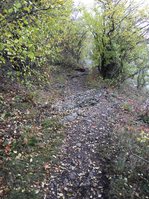
The original path as it appears on the north side of the Ottawa River.
This path still exists much as it did hundreds of years ago, cut through the vegetation along the north shore of the Ottawa River skirting around the tumultuous Chaudiere Falls and the the rough rapids just upstream from it. It sits quietly concealed, sadly vandalized with graffiti with its former commemorative plaques now missing. It is unfortunate that it seems neglected despite its historical importance in Canadian history.
On a more positive note, the ancient path is in an area that has surprisingly not been touched by development and retaining many of its original characteristics. Situated so close to the downtown core, you’d think the whole area would have been turned into federal office buildings or some sprawling residential development. However to the contrary, it sits as it has for thousands of years, the many unique features, both natural and manmade, waiting to be explored and enjoyed like the people before us once did so many years ago.
THE MISSION
I decided to retrace the same steps of the people that once used the path centuries ago, following in the footsteps of people like Samuel de Champlain, the fur trading Voyageurs, indigenous people and the Jesuit missionaries of the the 1600’s. They used this exact same path to go around the falls and rapids, and I have to say it was remarkable to experience the same adventures they encountered.
THE TRAIL
The trail begins at the NCC owned Brebeuf Park off the main road near the entrance to Gatineau Park. Here there is a statue of Father Jean de Brebeuf, a Jesuit missionary who travelled up the Ottawa River in 1634 to meet the Huron people where he later set up his missionary work before being tortured and killed by the Iroquois. An impressive bronze statue erected in 1930 to commemorate the journey of Brebeuf almost 400 years ago has had its descriptive plaque I’m guessing ripped off by scrap metal thieves, but no information is now present to tell you about the statue.
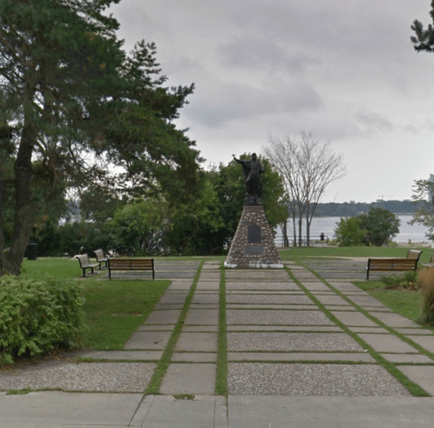
The statue of Brebeuf as it appeared in 2015 with its bronze plaque in place. (Google Streetview)

The Brebeuf statue as it currently appears with its plaque now missing.

Missing plaque.
Travelling east on the manicured path there is a rough cut trail that follows the shoreline of the river, and you can see rough cut stone steps used by former portaging travellers centuries before. It was quite amazing to literally take the same steps as Champlain and the other adventurers who stepped off their canoes here.

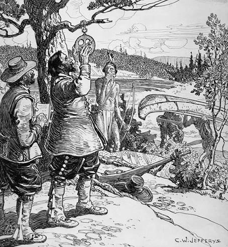
Champlain portaging on the Ottawa River c.1613 (CW Jefferys, Library and Archives Canada)
Inspiring views of the river I have never experienced before met my eye in addition to unusual rock formations, although I was saddened to come across yet another missing plaque that would have explained the path’s historical significance.

Another missing plaque that would have described the historical importance of the path.
The ancient rocks where native people and European explorers once docked their craft to portage the falls now lie covered in spray painted graffiti and trash. Not a fitting tribute for such an important and rare original piece of history.

A rock shelf where people portaged from for centuries now covered in graffiti.
Moving on, I imagined Samuel deChamplain in 1613 with his Algonquin guides in their birch bark canoes, lifting them up here to traverse the same trail I was on and came across an unusual rock formation like a giant stone amphitheatre that I’m sure has some archeological relics in it, but thought it best left to the professionals to study someday.

This large “bowl” depression off the path was probably used for some ancient camp.
There were more unusual formations, which were a combination of man made and natural features, some of which I’m sure are very old and pre-date any European contact. Again, I am sure someday the proper individuals will study these further if they haven’t already.

An unusually large boulder with rocks piled on the south side of it.
Next I came across a huge bay of water marked “Squaw Bay” on the map. Again, unusual rock formations, and traces of some kind of man made structures abound and I would later learn from a study done in 1901 by TW Edwin Sowter, that this was indeed an ancient campground:
“To all appearance, it seems as if this spot had been a landing place at the foot of an old Indian carrying-path, which led up to the head of that break in the canoe route of the Ottawa River caused by the little Chaudière Rapids…the western shore is strewn more or less, throughout its entire length, with fragments of worked flint, just as we meet with them at similar places… There is no doubt that, in prehistoric times, there were periods of tribal inactivity, during which an Indian community may have lived in such peace and comparative security, at Squaw Bay, as to have led even its younger members to indulge in the contemplation of making old bones ; but the situation of the dwelling sites of these palaeolithic people.” -Sowter, 1901, The Ottawa Naturalist, Vol. XV, No.6: 141-151
Sowter seems correct in saying this place was a former native encampment because there are countless ledges and areas of steep stone that makes a natural fortress with its high cliffs and moat like waters. Again, I defer to the professional archeologists and academics to study this intriguing area further.

The large bay and cliffs of Squaw Bay where an ancient camp once was.
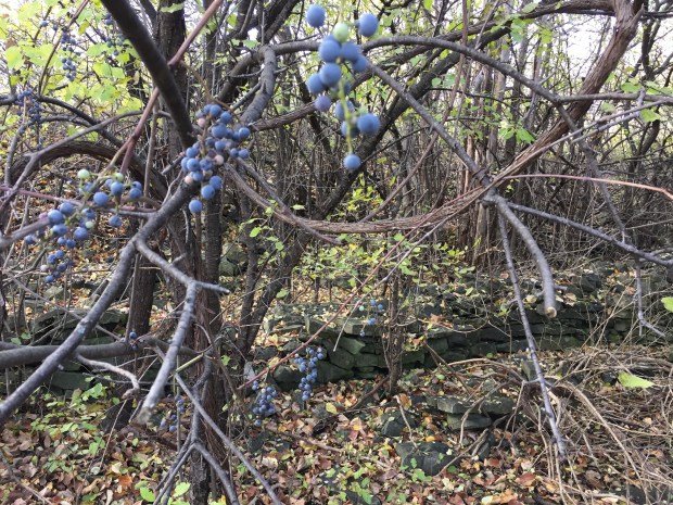
After making my way around Squaw Bay, I headed to where the now barricaded Prince Of Wales railway bridge hits the Gatineau shore, and there, off the path lies a a curious stone wall that seems to pre-date the railway which was built there in 1880. The railway embankment here cuts into this old stone wall which makes it look like it was built earlier. The wall is approximately 80 feet in length, 3 feet high, and 2.5feet wide. It is constructed in the ancient drystone masonry technique, but why it is lying tangled in wild grape vines surrounded by swampland is beyond me.

An old drystone wall.
Perhaps it was an old farming wall used to contain livestock from the Philomen Wright days of Hull in the early 1800’s, but the land is rocky and swampy making it inappropriate for farming or grazing. Without further study of this fascinating old wall overlooking the river, we may never know its purpose.
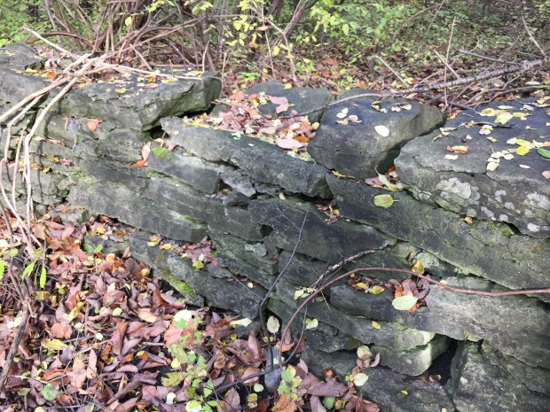
The old stone wall tangled in wild grape vines overlooking the Ottawa River, purpose unknown.
At this point I turned back, retracing the steps of ancient travellers, famous explorers, adventurers, and warriors who used this very same path, virtually unaltered from its original state. (minus the vandals and graffiti). It seems a shame that such an important trail has been neglected, with informative plaques lost to the prying hands of scrap metal thieves. With Canada’s upcoming 150th anniversary in 2017 perhaps the NCC as caretakers of this important piece of Canadian history will consider replacing the plaques and maintaining this concealed pathway through time, giving it the respect it has duly earned over the years.
Andrew King, November 2016
SOURCES
Google Maps
https://en.wikipedia.org/wiki/Jean_de_Brébeuf
http://www.historymuseum.ca/cmc/exhibitions/archeo/sowter/1901/sowter1901e.shtml

Love all of your stories Andrew.I would happily participate in any of your walks.This is so close to home and I would love to walk this path myself.Do you ever do any organized walks with groups?
Hi Catherine, thanks for reading and I appreciate the kind words. I do not do any organized walks since I’m busy with other job.
~~Thank you so very much, Andrew for this so informative Report !! I find it so inspiring that I must take to “The Trail” myself again, this week, and gather photos for my hunger for such wonderful examples of our interesting History !!
I made the treck in 1968, to see the Trail, but without camera in hand. I was retailing my Pen & Inks at the Bytown Museum that year, and doing my ‘Caricaturing’ on Canada Day, outside it’s eastern doors.
I hope to repeat my connection with the oldest building in Ottawa this coming Spring, and enjoy contributing to this great Museum.
Thank you again, for your Report I enjoy immensely your ventures into our History !!
Regards,..John (Jack) A.W. Cullen
Website: http://www.ipernity.com/crowquiller
Thanks Jack for your encouraging words…glad to know you are following along…more adventures to come!
I remember some years ago the City Council of Gatineau announcing a plan to promote this trail etc. Nothing came of it, no money. It is sad to see so much neglect and vandalism on a site such as this one. Tourism wise this could be such a great thing. Hopefully the NCC may do something.
Too bad! A great site!
How exciting to consider retracing the path.
Thanks for reading!
With regard to the drystone wall, it runs along both sides of the rail embankment, and there are portions of a similar wall on the west side up on the higher embankment where the upper track crosses over the lower one coming off of the bridge. It disappears under the power corridor, but may cross under the bike path and run down toward the river. All this suggests strongly to me that it must be related to the railway somehow, though I can’t quite imagine how.
Always enjoy your articles, and they always get me looking and poking around.
This is great…Thanks Jeff…I appreciate your comments and I’m glad you enjoy some follow ups. The rock wall is intriguing, and I also thought it had something to do with the railway, but it seems out of place near the embankment. An old farm wall perhaps that was cut through by the train?
Thanks for promoting the restoration of this trail. Stephen Hume in his book…Simon Fraser… writes about the various landings and portages along this section where brutal weights of goods were carried. He retraced on foot this part. I think he mentioned how the water levels/volumes used to much greater.
Quite a traversing path..a lot more rugged than I had imagined…people were hardy folks back in the day!
….used to be much greater.
Hello Andrew,
Several years ago I walked the portage trail and took a picture of the large plaque on the trail and am so glad that I did. It was installed October 1955 and told of its instillation by; I need to read it again and refresh my memory.
Regards Helen Cooper.