
All that remains of Ottawa’s oldest structure. (Google Streetview)
Recently I was passenger in a car driving west along Riverside Drive and noticed something out my window as traffic dragged to a halt at the intersection of Riverside and Bank streets. There, at the side of the road was a wall of old stone. A faded plaque was mounted on it, but the light turned green and we sped away, the mysterious stone wall of unknown origin left behind. What was this puzzling old wall that lies obscurely at the side of a road passed by thousands of motorists each day? A quick Google Streetview visit reveals it is a “Frankensteined” wall hobbled together by the NCC made up of the ruins of a cabin built by one of Ottawa’s oldest settler’s to the region: Braddish Billings. These are the ruins of Ottawa’s oldest remaining structure.
BILLINGS BOOM

A photo from the late 1800s of Braddish Billings cabin, the chimney of stone being what the wall currently at the side of the road is made from. (Image: “Bytown: the Early Days of Ottawa”)
After the nomadic indigenous people harmoniously lived in the region of the Nation’s Capital for centuries, the first to build a permanent structure here was an American by the name of Philomen Wright, who in 1800 built a cabin over in Gatineau (ruins are on NCC property, unmarked…that story here). Next to arise was a shanty trading post operated by Jehiel Collins near the Chaudiere Falls in 1809. Nothing remains of this cabin, property now owned by the NCC. In 1810 Ira Honeywell built a log cabin in Nepean. Nothing remains of this cabin either, just an NCC plaque hidden off Woodroffe Ave. near the Ottawa River that vaguely tells us of Honeywell’s cabin nearby. Next to arrive was Braddish Billings who built his place in 1812 at what is now the intersection of Bank St. and Riverside Drive. A cabin was built by Billings along with some farm buildings. These would become the first permanent structures built in Ottawa after the Collins and Honeywell cabins.

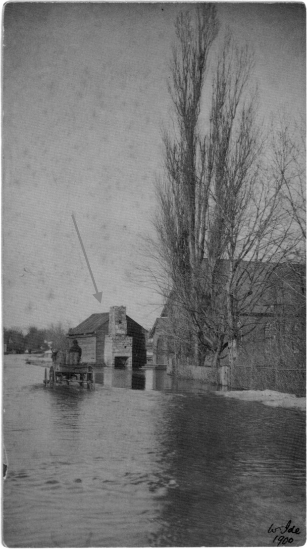
The early Billings cabin with stone chimney that was later made into a wall at the side of Riverside Dr. seen during a 1900 flood on the Rideau River. Methodist church beside it. (Image: Library and Archives Canada)
Billings made his cabin of round logs with no windows with an opening without a door. Billings was likely attracted to the riverfront site because of its close proximity to the Rideau River, its abundant timber, its creek, and its fertile soil. Along with building a sawmill, he began clearing the land and planted potatoes, hay, corn, and turnips. He also continued lumbering for Philemon Wright. His ventures proved successful and in 1829 he built a substantial estate on the hill above his original cabin, what we now know as the Billings Estate Museum, owned and operated by the City Of Ottawa.

The location of the Methodist Church in 1912 and the Billings cabin that would have been beside it (Image: Ottawa Fire Insurance Plans, Carleton University)
With his new big estate house, the original cabin structures Billings built in 1812 fell into disrepair, neglected and falling to ruin. A Methodist church was constructed next to one of Billings cabins, a wooden structure, that one book says is Billings first house, with a stone chimney that remained on site until 1960 when the NCC demolished it, and the church, for a new Riverside Drive. Taking stones from this old cabin, they built a small wall out of it, which is what we now see at the side of the road.

A 1928 aerial image shows the Methodist church and chimney ruins (circled in red) IMAGE: geoOttawa
The Ruins
With such few remains of Ottawa’s first permanent structures, I find it odd the NCC would demolish our oldest structure to build a wall out of it. Why not keep the original chimney and build a replica cabin around it, instead of a sad wall? I guess in 1960 the history of Ottawa was not as important as we view it today, but still, it seems unfortunate the original chimney of Billings first structures that lasted so long was demolished and made into an obscure wall at the side of the road.
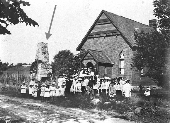
A photo from 1890 of the Methodist church shows the old 1814 ruins of the Billings cabin. (Photo: City of Ottawa)
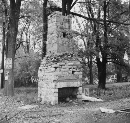
The 1814 stone ruins of the chimney that was demolished in 1960 and made into the current side-of-the-road wall. (Image: City of Ottawa)
Being the Nation’s Capital we have very few reminders of our inception, nothing remains of the Collins’ or Honeywell’s cabins. Yet, at the side of the road near Riverside and Bank we have some pieced together stones from our past.


If you pass along Riverside heading west, (you can’t see it if you are heading east) or, if you are travelling on the path along the east bank of the river, take a moment to observe what remains of one of Ottawa’s oldest structures.
Andrew King, February 2018
SOURCES
Library and Archives Canada
“Bytown” The Early Days of Ottawa, Nick and Helma Mika, Mika Publishing Co. 1982
https://www.oldottawasouth.ca/stories/item/3842-billings-estate-commemorative-wall

Awesome (unknown) history! Thank you for this!
Thanks for researching this. I’ve never noticed that structure, but will make a bike trip over there to see it for myself once the snow melts.
It’s unfortunate that the city saw no sognificance to this and other historical buildings at the time it was demolished.
Thank you, good article. The NCC does a terrible job of managing the precious assets it’s mandate is to manage, another example is the green belt where that they could encourage sustainable farming to help feed the region, instead they allow dozens of properties to languish and fall into disrepair. What a shame. Just more unelected bureaucrats enjoying life at the trough.
Always another interesting bit of Ottawa history to learn about.At least NCC kept the stones and made a plaque to mark the first settler Billings’ cabin.
Ottawa city council and the NCC haven’t improved much since 1960. They are still more than happy to allow Ottawa’s brief history to be demolished in the name of “progress”.
I am grateful that someone decided to build that wall and slap a plaque on it. It’s better than nothing. Oh and thanks for naming that mall after me.
Braddish! You’ve aged well!
…Richmond was the first group settlement in 1818 . It is currently celebrating its 200th. Anniversary .
yes! An old town…what is the oldest remaining building there?
That is an interesting piece!
Hi Andrew, thanks for your research. Since I work right there and walk near that wall, I have a question about the maps and photos and the location of Sawmill Creek. Presently, the creek is just east of the stone wall where BB’s log house was built. But on the map of 1912 showing the Methodist church, there is a creek farther south. The bridge is built over an island (Clifford Allen Island?) but that is not the case for the current bridge. I know it was washed out, but Bank Street looks to be the same as it is now. So are we looking at inaccurate maps? Or did Sawmill Creek change? Did the roads, Bank or Metcalfe Road, change? Anyway, just pointing out some inconsistencies with the location of the bridge island, and Sawmill Creek.
Hello Richard, thanks for the note and interest in that post. You are very perceptive and indeed the maps and creeks do not match as you noted! There is a reason for this….The NCC when they made the new “Riverside Drive” and demolished the stone ruins, they also diverted the creek! They took it from its original course and re-routed the creek to empty out on the east side of Bank St! You can clearly see the change if you visit the amazing GeoOttawa maps. geoOttawa.com
Thanks for your query and I hope that answers your very thoughtful question! Try that GEoOttawa map link, it reveals a lot of history!
AK
Thank you again, very interesting about the creek. I imagine BB’s sawmill location might have become lost with the redirection and NCC work. I tried the site geoOttawa.com but it no longer exists or is experiencing a domain issue. I will check other maps and Lost Ottawa for the island associated with the bridge and the sawmill location. I love your site!
I have seen that structure 1000 times and did not know what it was …..Typical Ottawa doing something like this. They stifle it or dump huge amounts on other obscure sites. Thank you for clearing up “the wall”.
Absolutely love finding these gem posts about Ottawa’s historical past. Thank you so much for writing it and sharing it with us. I would suggest that they took down the chimney and built the low wall to minimize the toppling-on-a-person-and-have-them-sue-the-City risk. Of course, they didn’t seem to have that concern on the grounds of the MacKenzie King Estate.
Thanks for reading, and you are probably correct!