STRANGE THINGS: Old native trails once marked by bent trees.

IMG_9612

BENT TREES MARKERS OF THE PAST

A hike through an undisturbed forest is something of a treat, one can clamber over rocks and fauna that has never been traversed by others, providing an escape from the crowds and busy roads of the city. These days it is not easy to get lost in the woods with cell phone apps and GPS to guide our way…but something I recently stumbled upon revealed someone long ago had also trekked the same woods, using not a GPS to guide them, but a strangely bent tree…

THE MYSTERY OF THE CROOKED TREE

Before a network of highways and roads guided us across this country and even before the arrival of Europeans in North America, a network of trails and paths used by native people took them from place to place. What existed was a roadmap of trails, a series of marked paths to guide travelers on a safe route across the wilderness.

MAP1847

The first record of trail marker trees appeared in a document called “Map of Ouilmette Reservation with its Indian Reminders dated 1828–1844”. This map shows actual drawings and locations of existing trail marker trees.

These ancient trail routes were later used by European settlers to build rudimentary carriage roads that would later become the paved asphalt roads we use today. Back then, there were no signposts, rest stops or tourist info centres to point us in the right direction. Instead these native trail blazers built “trail marker trees”, unique bent trees that pointed the passer by in the right direction. These bent tree markers resemble strange oddities of nature if you can find one, markers of the old trail travellers. Once sapling trees bent with rawhide or vines, they now give us mysteriously shaped trees in the forest.

THE BENT TREE SYSTEM

Trail_Marker_Tree_located_on_the_border_of_Mettawa_and_West_Lake_Forest_IL-lead-image

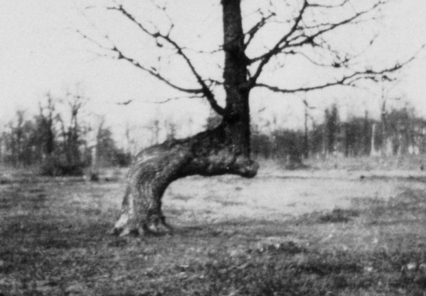
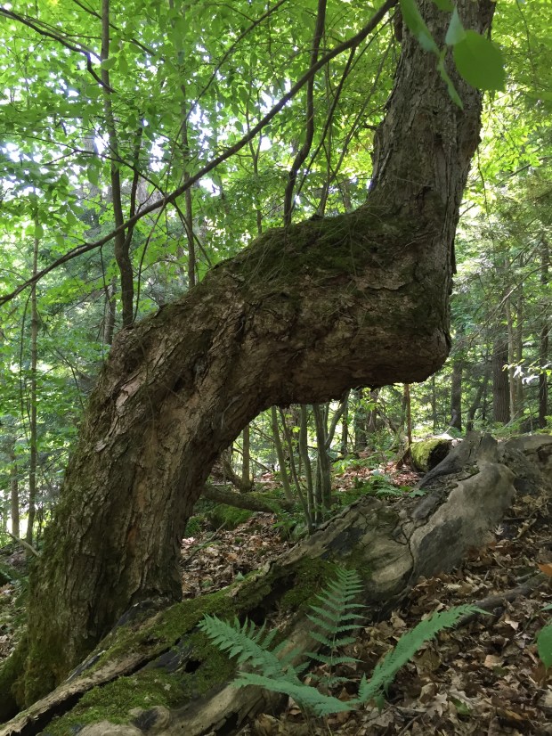
A bent tree trail marker in Illinois. (Source IndianCountry Today Media)

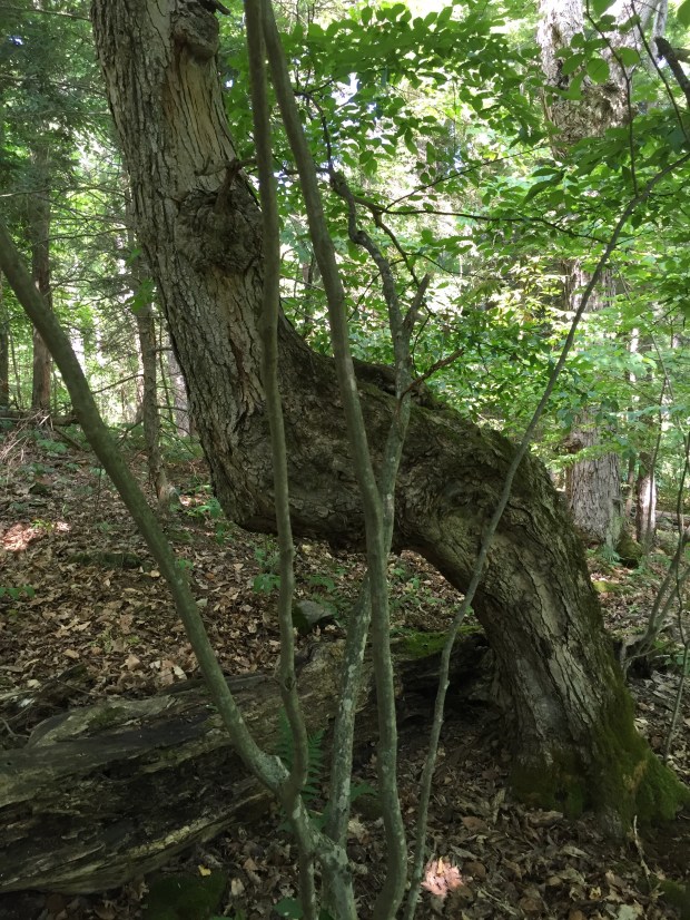
A while ago a friend told me about the bent tree trail markers, but I was skeptical of their existence since nature can behave strangely, giving us oddities that seemingly defy any natural explanation. I thought bent trees were just another one of these natural anomalies until I came across one last week. There, high up on a high rocky ridge was the definite shape of a bent tree, its presence caught my eye much like it would have to a forest traveler many years ago. Upon closer inspection, it became clear that this might not be natural, and could very well be one of the old bent tree trail markers from long ago.

IMG_9610

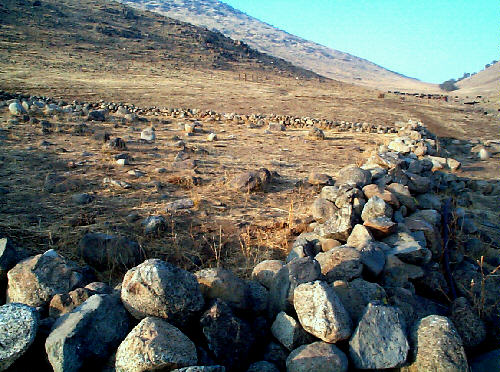
Discovering the strange bent tree on a rocky high ground near Opinicon Lake. (tree on left)

In the 2011 Field Botanists Of Ontario Newsletter, an article written by Paul O’Hara explains in great detail the strange but fascinating “bent tree” markers made by indigenous people in the Toronto area hundreds of years ago. You can read that piece here Also of interest was an informative piece written by William McClain of the University of Illinois piece written by William McClain of the University of Illinois who explains how and why these odd bent trees were formed. Trail-marker trees were important to the indigenous tribes who used used them while traveling, using their own methods to make them. Generally, oak saplings were bent and tied to stakes or rocks using animal skin or wild vines. The direction the tree was bent would indicate the proper course to the traveler. These bent marker trees were usually placed on high ground for visibility and would usually point towards a waterway, a settlement or a lake, the route best taken to find these places.

In 1965 archaeologist, Robert E. Ritzenthaler, wrote an article about the bent tree trail markers that appeared in the Wisconsin Archeologist, Volume 46, Number 3, 1965, claiming any trees 200 years of age or younger would have to have been made by pioneers with early Europeans quick to copy this practice of Native Americans. The practice was widespread throughout North America, and Raymond E. Janssen, in the February 1940 issue of Natural History magazine, mentions their distribution into the Great Lakes region.

Dennis Downes, President and Founder of the Great Lakes Trail Marker Tree Society explains “Some of these trees would have brought them to fresh water springs, the preferred source of water used by the Native Americans and settlers alike. Other Trail Marker Trees would have guided them to areas with exposed stone and copper deposits needed for their adornments, hunting implements, and everyday tools. Yet, others would lead them to the areas where they could gather medicinal plants as well as plants used to make their dyes and paints. The Trail Marker Trees would have taken them to ceremonial sites and occasionally the burial sites of their ancestors. Also, in relation to the rivers, these trees would indicate areas of portage and safe crossing.” Downes continues to research and document the bent trees of the Great Lakes, and his impressive amount of work on these trees can be viewed here.

Indian Country Today Media Network, which covers Native American and First Nations of Canada culture, sat down in 2013 with Don Wells, author of “Mystery Of The Trees” and discussed the history of these strange trees. Wells explains that back in the 1600s and 1700s, when natives were traveling from the Atlantic to the Pacific, and from Canada to Mexico, there were trails all over North America. “They didn’t have GPS or a map, so to find their way from A to B and back home again, they had marker trees, or trail trees, or a signal tree or a yoke tree”. explained Wells, who also produced a documentary about these fascinating historic trees. “These trees would be bent as saplings, when they were about ¾-inch in size, and tied down. They would be left that way for a year and lock into that position. They used them to mark trails, crossing points on streams, springs to find water and medicinal sites where they would get plants.

Read more of their info on bent trees here.

HOW BENT TREES WERE MADE

trail tree

How a bent tree trail marker would have been made. (Sketch by author)

A sapling of either oak, maple, elm or other hardwood that could bend easily would have been staked down, pointing in the direction of interest. As the sapling grew, its side branch would grow upwards, and later form the main trunk of the tree. (see sketch)

The bend of the tree would be a few feet off the ground so the horizontal trunk could still be seen in the deep snow of winter. Sometimes there would be a hollow made in the bend to leave message sticks or other parcels.

DISCOVERING THE BENT TREE

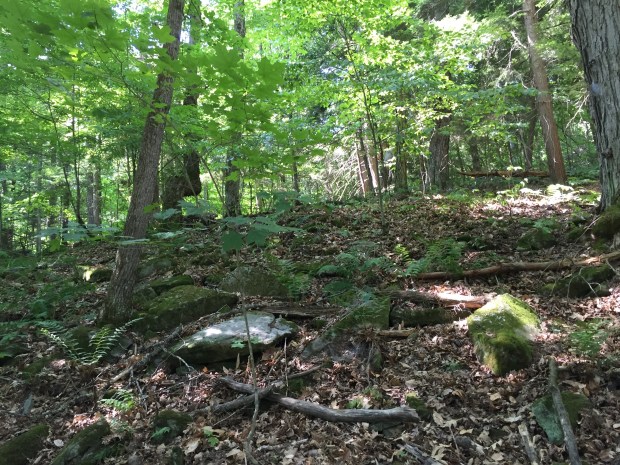
On a recent trip to Opinicon Lake we traveled down an old road that was previously used to transport rocks quarried from nearby Elgin used in the construction of the Rideau Canal locks. This winding, narrow road led from the main road of Highway 15 to the Rideau system at Davis Lock. I noticed high up on a rock cliff an unusual tree that matched the description of the “marker trees” my friend had once told me about. I grabbed some gear and hiked through the forest to inspect the tree in closer detail and sure enough it was a strange bent tree, pointing in the direction of Opinicon Lake and the connection between two lakes. Upon further inspection it was revealed that another bent tree was also on another area of high ground. It seemed to be consistent with the old bent tree practice: on high ground, bent towards a place of interest, along a very old old road that was most likely once a trail.

IMG_9617

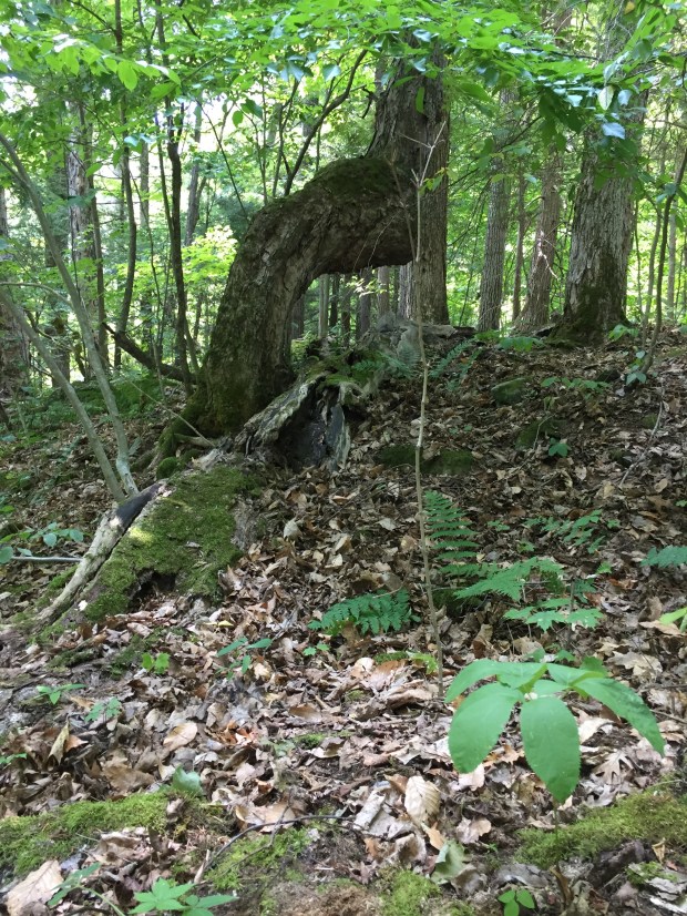
Bent tree pointing towards Opinicon Lake.

In McClain’s article it is also mentioned that the settling pioneers also adopted the bending of trees method to mark a path, so it is likely that perhaps the one I found was made by one of the early settlers to the area before, or during construction of the Rideau Canal system. Perhaps the trail was marked by natives as away to the waterfalls of Opinicon Lake (Which is a native word for “potato”).

BentreeOpinicon

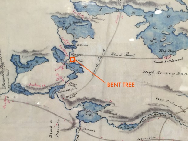
Map by Col.John By from 1830 showing the route of his proposed Rideau Canal system. The bent tree was found near Davis Lock. Note lack of roads and former name of Opinicon Lake was “Mosquito Lake”.

The Rideau system was once an important route used by the First Nations people to travel between Kingston and Ottawa, so finding a trail marker tree along it is not unusual. The tree also contained a hollowed out area in the bend, as mentioned before for leaving message sticks. It was fascinating to see one up close and in person, its location a once prominent point of land for a traveler long ago. I will not dismiss the possibility that it is or natural origin but the evidence and research seems to prove otherwise.

ARE THERE MORE OUT THERE?

Many of these unique bent tress have been lost to road construction, development, logging, or just uncertainty as to what they were. When an original trail was later made into a road, many were most likely lost, yet they may remain as the last living piece of history connecting us with our first nations people and their unique way of life.

IMG_9611


As with any historical mystery, some will continue to debate their origins and deem them as natural phenomena, but with so much evidence proving otherwise, it seems unlikely these mysterious trees are the product of natural mutation. These unique markers to our past have been with us for centuries yet they remain largely forgotten in the unexplored wilderness of our region. Who knows how many more are out there waiting to be found, lost markers to the past, silently awaiting their next visitor.

Andrew King, August 2016

OttawaRewind.com

SOURCES

https://en.wikipedia.org/wiki/Trail_trees

http://www.greatlakestrailtreesociety.org/index.html

https://web.extension.illinois.edu/illinoissteward/openarticle.cfm?ArticleID=26&Page=2

http://indiancountrytodaymedianetwork.com/2013/05/03/groups-quest-find-and-save-indian-trail-trees-149169


Sea Monster in the Ottawa River


800px-Sea_serpent

For hundreds of years sightings of unclassified marine creatures have filled the log books of ships, menacing creatures that lurk beneath the waves. Often called “sea serpents”, these elusive creatures often appear on old maps as fanciful drawings of sea faring monsters with great teeth, devouring entire ships.

Screen shot 2016-07-05 at 9.20.38 AM

1550 map of Canada showing sea monsters off the coast. 

Scientists currently believe these sightings can be best explained as documented creatures such as the lungfish, oarfish or even eels. Yet there is one sighting of a sea serpent that goes beyond just a visual interpretation, an incident that involved one being captured. Not on the ocean, but right here in the Ottawa River.

OTTAWA RIVER SEA SERPENT

Along the Ottawa River near Arnprior the waters widen as they stretch north, resembling more of a lake than a river, hence it being given the name Chats Lake. It reaches from the once mighty Chats Falls, now dammed for a hydro station, northwards to more rapids at Portage Du Fort near Renfrew. Bookended by these two waterfalls, this 30km long lake was the scene of much logging and timber transport during Ottawa’s lumber boom of the mid to late 1800s.

IMG_9147

1831 map of Chats Lake, stretching 30km from Chats Falls near Arnprior to Renfrew.

At that time, large volumes of lumber was being transported downriver to the busy mills of Bytown. Many steamships were employed to carry both crews and supplies, as well as to tow logs to various points along the river.

During this period of increased steamship travel on Chats Lake a number of these ships began to spot an unusual water creature of immense proportions in the lake. Described as a large serpentine creature, a well respected Arnprior citizen by the name of Robert Young related to the local newspaper his glimpse of an aquatic monster in Chats Lake, which he described as “being of enormous size and proportions”. Soon, those on the water in boats and those that swam in its cooling waters grew fearful of what sounded to be a large serpent creature in Chats Lake.

Below Chats Falls, an 1880 newspaper article relates the story of a boy in a canoe encountering a serpent creature “about the size of an ordinary telegraph pole” and explains how an unknown serpent creature lurks in the Ottawa River, witnessed by many.

Screen Shot 2016-07-06 at 10.33.41 AM

1880 newspaper article describing the Ottawa River monster.

A few years after Young’s sighting, and also near Arnprior, Captain Brown of the steamship Alliance, saw a creature of the same description. Large. Serpentine. Fast.

With summer in full swing, and like something from a Spielbergian film, the legend of the sea serpent in Chats Lake reached epic proportions. Then, one hot summer day in 1882 the creature was spotted again, but this time there was no escape for the Chats Lake Monster.

steamer

In 1882 a steamship Levi Young, similar to the one pictured above, encountered the frightful beast of the river. Later its crew captured and killed it. 

Announced in the Arnprior Chronicle on August 26, 1882, the elusive sea serpent of Chats Lake had been captured. Having struck terror in the hearts of superstitious lumber men of the time, superstition became reality when the steamship Levi Young encountered the legendary creature of the lake. Departing the Snow Rapids, near present day Castleford where the Bonnechere River empties into the Ottawa River, the crew of the LeviYoung noticed a huge serpent creature swimming ahead of the boat. The newspaper article states that “Mr. John Durgan, chief engineer, and a deck hand, named Shaw, jumped into a boat and started in pursuit of the reptile. They succeeded in getting within striking distance of the serpent when Mr. Durgan struck it a blow over the head with his oar.” This in turn enraged the creature who churned the water into a furious froth, attacking the boat and the men inside. An oar was used to lay a powerful blow to the creature’s neck where it writhed to rest and was then towed back to the steamship.

serpentscale

Once back at the ship, the crew heaved the lifeless serpent aboard the deck of the Levi Young where it was laid out for inspection. Aboard the ship lay dead a serpent creature measuring 11 feet in length and more than a foot in thickness. The jaws of the creature were pried open and measured a span of half a foot.

No further records of the creature have been found, and the whatever happened to the carcass of the Chats Lake creature remains unknown. Was it some sort of ancient fish trapped between the falls on either end of the lake after the prehistoric Champlain Sea receded? Was it an abnormally large snake, catfish or eel? It is unclear as to what exactly plied the waters of the Ottawa River those years in the late 1800’s, but there is one thing for certain, a large serpent creature was indeed captured. So as we lazily splash around at our cottages this summer without fear of sharks or jellyfish, remember there was once another type of creature lurking in the dark waters of the Ottawa River, a creature that could still very well be out there, and possibly very hungry.

Andrew King, July 2016

SOURCES

Giant Serpent Killed?

The Quebec Daily Telegraph, August 4, 1880

The Upper Ottawa Valley: A Glimpse of History, by Clyde Kennedy


Canadian Boat History For Sale…in America


Miss-Canada-IV-Returns-to-Muskoka_0001Former Speed Record Holder Miss Canada IV listed for sale on Antique Boat America

In what could be another unfortunate example of our country’s oversight in preserving our own history, a signifigant piece of it appears for sale in an American classified ad. Antique Boat America recently listed speedboat record holder Miss Canada IV on their website for $775,000 US dollars. Peter Mellon from Antique Boat America does mention though that
they are the only Antique and Classic Boat Broker in North America with a Canadian presence / office and full time staff. They are working hard to make sure this piece of Canadian history remains in Canada. Mellon states they are “working diligently to keep this boat in Canada as it is an iconic piece of Canadian race boat history.”
Miss Canada IV is a late 1940’s Unlimited class race boat originally owned and driven by Harold & Lorna Wilson who, on Sunday, October 2, 1949 took Miss Canada IV into the history books. The result was a North American speed boat record of 138.865 m.p.h., which exceeded the best American boat by 12 m.p.h. Miss Canada IV was built by Greavette boats in Gravenhurst, ON and powered by a 3,000 HP Rolls Royce Griffon engine, the largest aero engine in the world at that time. The powerplant was still on the British classified list when British authorities allowed it to be brought to Canada to challenge the Americans for the coveted Harmsworth Trophy. The Harmsworth Trophy was the pinnacle of international speedboat racing with each boat entered having to be entirely from the country of which it represented. The Rolls Royce Griffon engine was a 37 litre, V-12, liquid-cooled airplane engine designed and built for WW2 use, mainly in Shackleton bombers, and in Spitfire fighters near the end of the war.

IMG_6145

The WW2 era Rolls Royce V12 Griffon engine that powers Miss Canada IV.

In 1950, the Americans grew wary of this new speedboat marvel from Canada, and the Harmsworth Trophy was where their concerns were put to the test. Unfortunately, in the first heat of the race, Miss Canada IV suffered serious steering and hull damage and had to be pulled from competition. She was later taken to Picton, ON where she attempted to break the World Speed Record in the Bay Of Quinte but suffered a gearbox blowout nearing 200MPH. The Wilsons sold the boat to Gord and Jim Thompson, who raced her under the Miss Supertest name before retiring her to build their own boats.

miss_canada_iv_record_run

Attempting to reach the World Speed Record in the Bay of Quinte near Picton, ON (Photo lesliefield.com)

Apparently lost in a fire, Miss Canada IV was found years later decaying in a farmer’s field sometime in the 1980s near Windsor, ON. Harold & Charles Mistele bought her and restored her before it was placed in the Ingersoll Cheese & Agricultural Museum. In the 2000s it was acquired by Bobby Genovese of Lake Rosseau in Muskoka where it was completely restored and unveiled at the Gravenhurst Boat Show. I was in attendance and had the pleasure of being rumbled awake by the sound of its V12 engine one morning.

IMG_7831 (2)

Miss Canada IV unveiled after restoration in Gravenhurst, On in 2013.

Miss Canada IV appeared in Picton last year where I got to see her up close again as she attempted to break the speed record on the same waters she once plied in 1950. Yet those efforts were thwarted once again when bizarre winds and weather prevented Miss Canada IV from performing.

IMG_6140

Keeping an eye on this Canadian boating marvel, I recently noticed this important part of our nation’s history ironically appear on the Antique Boat America classified ads. These are good people at Antique Boat America having dealt with them in the past, and I know they would like nothing more than this boat to remain in Canada. We just need someone to make this happen…like our Canadian Museums. Yet, I fear due to “budgets” and whatever other excuses, this will be an unlikely outcome. Here is the ad with live link to it below:

Screen Shot 2016-06-07 at 10.14.07 AM

http://www.antiqueboatamerica.com/ab_list_boatNew.asp?Left=&Type=ViewBoat&BoatId=37213

Her proud Canadian heritage all up for grabs to anyone with $775,000 USD. To have such an important piece of Canadian history end up anywhere else than in a Canadian museum would be a tragic fate that this country would regret. I hope someone will please take notice and make sure Miss Canada IV remains in Canada.

Thank you.

Andrew King 2016

WHEN HELL FELL FROM THE SKY: Fighter jet slammed into convent 60 years ago


convent

60 years ago on May15 1956 a fighter jet screamed into an Orleans convent burning alive 11 nuns and a priest. (photo: City of Ottawa Archives)

Sixty years ago to this day the flames of hell consumed the souls of 11 nuns and two airmen when a fighter jet screamed down from the heavens and exploded into a remote Ottawa convent in the fields of Orleans. On this 60th Anniversary of what is called The Convent Crash, let’s take a closer look at the events and aftermath of this gruesome chapter in Ottawa’s history.

Rocket_train_moo-sb_item660_55_moo1-1p3_

Here is an Ottawa Uplands air base CF-100 being loaded with fuel tanks, the same jet that would have slammed into the convent

On the evening of May 15, 1956 two CF-100s were scrambled from their base at RCAF Station, 445 Squadron Uplands to intercept an Unidentified Flying Object heading towards Montréal. The time was 10:37pm and the Canadian built CF-100 Canucks quickly reached their target which turned out to be a RCAF North Star flying from Resolute Bay to Dorval Airport. The two planes then decided to ascend to to 33,000 feet to practice interception techniques and burn off excess fuel before returning to base.

445-26

Ottawa’s 445 Squadron markings on the CF-100 that slammed into the convent.

One of the planes then landed but the other jet reported they were going to continue flying, burning off their excess fuel. This was to be the last communication received from the aircraft.

445-cf-100-formation

CF-100s from Ottawa’s Uplands base flying in formation.

The plane was piloted by F/O William J. Schmidt (age 25) and F/O Kenneth D. Thomas (age 20), two young men who would soon scream downwards and take eleven nuns and a covent into a fireball from hell. No one is quite sure what happened at 33,000 feet that night sixty years ago, but one explanation says that the oxygen masks of the two crewmen malfunctioned and they lost consciousness, sending the jet into a death dive. (Here is a short video of a real CF-100 fighter jet I filmed at RMC Kingston.)

tarling1958yow

a CF-100 pilot prepares for a mission.

Below, on the outskirts of Ottawa, The Sisters of Villa St. Louis were getting ready for bed in their convent located on the shores of the Ottawa River. In the heavens above, a fighter jet was screaming down at 680mph and slammed into the remote convent, ironically one of the few buildings in the area at the time.

map

The convent is the the unmarked building complex near the shore of the Ottawa River.

Upon impact, the jet exploded into a ball of flames, igniting the jet fuel and weapons munitions aboard the plane, vapourizing the three storey, 70 room building, and instantly killing the airmen. What happened next was a scene from hell as burning nuns jumped from windows, while others screamed as they were trapped and frantically trying to open windows. Those unable to escape their rooms died of smoke inhalation.

jetheadline

Headlines in the Ottawa Citizen report the grisly scene of the scorched earth scenario in Orleans.

Nearby neighbours rushed to help at the gruesome scene, but little could be done to save the trapped nuns inside. When the flames were finally extinguished, 25 people had made it out alive, but 11 nuns, a priest, a servant, and the jet crew perished. In what was one of the worst air disasters in Ottawa’s history, the RCAF began an investigation into the disaster but could not determine what had happened. The jet’s crew had given no indication that they were in any trouble, and there was no attempt to eject from the aircraft. The plane could have easily hit the vacant fields or the empty waters of the Ottawa River, but for some ironic reason it slammed into the nuns convent like a godforsaken curse.

pilots1

The two airmen killed in the crash (Ottawa Citizen)

The RCAF cleaned up the site and today the Bruyere Centre Saint Louis sits on the scene of crash. A memorial marks the location where 15 souls lost their lives the night hell fell from the skies.

Andrew King, May 2016

SOURCES

https://en.wikipedia.org/wiki/Convent_Crash

http://ottawa.ca/en/jet-crash-villa-st-louis

Google Maps

http://www.canaero.ca/subpages/Article%20content/cf-100rocketspage1_Rocket%20podsa.html


GUNFIGHT AT THE STONE CORRAL: Wild West Outlaw was from Ottawa

splashpageThe era of Hollywood Western film reached its peak in the 1960s and 70s with film and television productions depicting the gripping adventures of the Wild West. Mostly fictional tales, these Westerns created some of the most memorable moments in cinematic history, from the classic “The Magnificent Seven” to Clint Eastwood’s collection of Westerns. Yet the greatest Western story yet to be told is not from the Wild West, but from the fields of west Ottawa…

GUNFIGHT AT THE STONE CORRAL: California’s greatest outlaw from Bells Corners

If you drive south on Greenbank Road past Hunt Club into the NCC Greenbelt, there is a parcel of land that stretches west towards Cedarview Road. It’s a flat field owned by the NCC with an annual crop growing up from its soil but nothing else marks its place in history, a place where something else grew, the Biggest Outlaw In California History, a man by the name of Chris Evans.

Screen Shot 2016-03-18 at 6.15.59 PM

Screen Shot 2016-03-18 at 6.16.32 PM

This parcel of NCC property off Greenbank Road was once home to the most hunted outlaw of the Wild West.

Thomas and Mary Ann Evans, residents of Bells Corners brought their son Chris into the world on February 19th 1847. One of their many children, Tom and Mary Ann raised Chris to work the farmland they owned between Cedarview and Greenbank roads, just southeast of Bells Corners, the same property now owned by the NCC.

BC1880marked

Finding a map of the Bells Corners area from the 1880s I was able to locate the Evans farm and superimpose it over a current Google map to find their property.

BCnowmarked

I3704;I4018

Chris Evans parents who raised him in Bells Corners.

Here young Chris worked on his parents farm until the age of sixteen, at which point he decided that he wanted to “seek out his fortune”. Chris headed south to the United States and soon joined the Union Army fighting against the Confederate forces in the U.S. Civil War.

ARC-526388

Evans served with Custer but deserted him months before his epic ‘Last Stand’ battle.

A natural sharpshooter and good with gun, Chris stayed with the Army as a talented scout after the Civil War ended and served alongside American legend Lt.Col George Custer, of “Custer’s Last Stand” fame, but Evans later deserted the Army and headed to California and the emerging Wild West. Once in California Chris Evans met a girl by the name of Molly Byrd, of whom he married and settled down with on a farm of his own in Visalia, California.

500223_951213f8bwu22l2z332655_C_96x128C

Molly Evans.

Here in the quiet hills of San Joaquin Valley, Evans worked as a miner, teamster, lumberjack and railroad employee. He hired a young man by the John Sontag to work on his own farm, who also worked the railroads with the Southern Pacific Railroad. Sontag was injured on the job, then fired by the company, sharing in Evans contempt for the railroad companies. Evans and Sontag became close friends, even going into a livery business together in Modesto, California. They both shared a dislike of the Southern Pacific Railroad, a sentiment shared by many in the area since the railroad company expropriated many properties under market value. A fire burned down their Modesto business in 1891, leaving them both bankrupt and forcing them to return to Visalia. It was at this time an unusual number of train robberies occurred perpetrated by two masked men.

On August 3 1892, a Southern Pacific Railroad train was held up near Fresno by two bandits who made off with $50,000. Authorities followed the bandits tracks which lead to none other than Visalia. Authorities had grown suspicious of Evans and Sontag and paid a visit to the Evans farm. Two men, Railroad Detective Will Smith and and Deputy Sheriff George Witty approached the Evans residence when Evans and Sontag appeared with shotguns. The two parties engaged in a firefight, with Evans and Sontag blasting their way out, wounding both lawmen and killing another who arrived on the scene. This began the largest manhunt in California’s history.

Screen Shot 2016-03-17 at 8.53.52 PM

An enormous posse hunted Evans and Sontag.


Now on the run, buddies Evans and Sontag had a posse of dozens of lawmen, 300 armed civilians and a score of bounty hunters looking to claim the $10,000 reward for their capture, dead or alive. The pair were well liked in the area by the locals who provided them with the necessary cover and hiding places while the epic manhunt ensued, and they were able to avoid any confrontation for about a month. Then one day in September, a posse tracked Evans and Sontag to a cabin in the mountains. Here the posse approached the fugitive’s cabin but were quickly ambushed by Evans and Sontag who blew out the windows and shot up the approaching posse, killing a Marshal and another member of the posse. An eight hour shootout resulted in Evans and Sontag escaping further into the mountains where they spent the winter camping.

In the spring of 1893 another special posse of lawmen lead by a new marshal, Marshal George E. Gard kept his posse small and secret, stealthily tracking the fugitives and slowly gathering information without being detected by the two outlaws. Marshal Gard soon got a tip that said that Sontag and Evans were planning a visit to Evans’ wife, Molly, who was located at the Evan’s cabin about ten miles northeast of Visalia. Gard and his posse headed to the Stone Corral, next to the Evans home, so they could begin searching the area for the two bandits.

Once at the Stone Corral, the Marshal and his posse of three men, Hiram Lee Rapelje, a deputized bounty hunter, Fred Jackson, a policeman from Nevada and Thomas Burns, holed up in a cabin to wait and watch if Evans and Sontag would pass by. The tip would prove to be correct, since soon afterwards on June 11th, 1893, Evans and Sontag appeared on the hill overlooking the Stone Corral. Evans wanted to fire a few shots into the cabin below to see if anybody was there, but, because the place appeared to be empty and because the cabin was known as a “lover’s rendezvous,” Sontag talked him out of it.

CE1

Sketches depict the epic gunfight at the Stone Corral…Initials of the characters shown. (sketches by author)

CE2

The two men got off their horses and headed down to the cabin where Jackson, the policeman, was keeping watch. Beside a haystack Evans looked down and saw someone in the cabin window and quickly opened fire with his Winchester rifle.

CE3

Jackson hearing the shots, picked up his shotgun from the porch and blasted the pair near the haystack where Evans was hit by the blast.

CE4

The two retreated behind the haystack knowing they were now being ambushed, and lay as flat as possible to avoid the incoming fire from the cabin below. The San Francisco Examiner later interviewed Marshal Gard who gave his account of the gunfight at Stone Corral, who said “I will take Chris, and you take John.” But before I had time to get a line on Sontag’s breast, Fred fired. Evans fell endway, with both hands up. Sontag dived for the straw pile, and I let go as him. Then both of them, from behind the strawstack, turned loose their big Winchesters. Bullets whizzed through the house.”

shootout2shootout1

Enraged at the ambush, Evans and Sontag lead a barrage of angry shots into the cabin, and Jackson, hoping to flank the two from the side ran out the cabin and approached the haystack from the side…Evans caught sight of the approaching policeman and blasted him with his revolver taking out Jackson’s kneecaps and legs. Sontag at some point was hit in the stomach and in the right arm, taking him out of the battle. With night falling, the shootout left the adversaries without visibility.

CE5a

Now dying, Sontag pleaded with his friend to escape in the dark, but Evans refused to leave his friend’s side. In great pain Sontag also begged Evans to shoot him, ending his misery of pain, but again Evans refused. Sontag begged his friend to leave and so obeying his dying wish, Evans grabbed his rifle and began to crawl into the darkness. Spotted by Rapelje trying to crawl away from the haystack, the bounty hunter opened fire and started running towards him. Evans, however jumped to his feet and ran into the darkness without shooting back. He was hit in the face and arm from the blast of the shotgun, yet Evans managed to escape.

stone3

The Stone Corral where the epic gun battle occurred on the outskirts of Visalia, CA (photo: eshomvalley.com)

Now left for dead, Sontag raised his own revolver to his head in an effort to end his misery but the gun missed, injuring the dying outlaw even more. Calling out for water, the posse in the cabin ignored Sontag’s pleas and stayed in the cabin until dawn when reinforcements arrived and the posse rushed the haystack to find Sontag lying there barely alive. A reporter arrived and the posse heaved up Sontag’s almost lifeless body for a photograph in that would soon appear in the San Francisco Examiner. Sontag was hauled away on a wagon to a jail cell in Visalia.

Battle_of_Stone_Corral_1893

Just after the gunfight ended, the posse found the wounded Sontag and propped him for a photo.

Meanwhile, Evans, although badly wounded, walked six miles up Wilcox Canyon to another cabin and begged the owners for help. They bandaged him up but a few days later, they informed the police they had a fugitive in their cabin. A large force of lawmen surrounded the cabin expecting Evans to take them on in another massive shootout, but Evans surrendered without further resistance. He was taken to the jail in Visalia and put in the cell next to the dying Sontag. His friend would later die of his wounds in that jail cell on July 3. Evans own wounds resulted in his left arm having to be amputated and the loss of his right eye. Chris Evans’ trial was held Fresno, CA and on December 13, 1893, he was sentenced to life in Folsom Prison.

chris-evans-page-001

Chris Evans shortly after his capture and arm amputation and right eye removed from the gunfight at Stone Corral.

chris-evans

Chris Evans, outlaw. Mugshot.

Despite the lack of an arm and an eye on December 28th Evans escaped from the Fresno jail with a fellow prisoner leaving a Marshal John D. Morgan wounded. Once again, the Ottawa native returned to Visalia to see his wife and children where he was captured again without incident. Evans was then sent to Folsom and remained there until May 1911 when he was released under the conditions that he would never set foot in California again. With his wife and family he moved to Portland, Oregon, where he read, tended to his garden and cats, living out his remaining days quietly and without incident.

I4026

An elderly armless outlaw now living in Portland, OR, and the subject of the largest manhunt in California history, Chris Evans lived out his quiet life with his cat and wife.

Evans claimed he never did rob a train and he only ever fired his gun in self defense. The boy from Bells Corners died in 1917 and is buried in Mount Calvary Cemetery in Portland, Oregon.

5954269_1005852294

Evans grave as it appears in Portland, OR. (photo: findagrave.com)

His parents, Tom and Mary Ann, died in 1898 and 1893 respectively and their graves can still be seen today in the Union Cemetery in Bells Corners. Chris’ Evans wife, Molly, would spend her last days in Laguna Beach, California where she died in 1944.


I4018-I3704tomb

Chris Evans’ parents are buried in Bells Corners. (photo: Bob Switzer)

The Wild West is full of characters, most notably those that lived an adventure of crime, but for Ottawa’s Chris Evans, the greatest outlaw in the history of California, he always maintained his innocence til death, stating “I am guilty of no crimes. I killed men who were trying to kill me.”

I eagerly await the Hollywood Western film that should be made based on this fantastic tale of the Outlaw From Bells Corners.

Andrew King, May 2016

SOURCES

http://www.switzergenealogy.com/showmedia.php?mediaID=154&medialinkID=281

https://en.wikipedia.org/wiki/Christopher_Evans_(outlaw)

http://www.eshomvalley.com/sontag_evans.html

CHRISTOPHER EVANS (1847-1917) & JOHN SONTAG (1862-1893) Train Robbers

https://books.google.ca/books?id=HjMozd3dBjoC&pg=PA78&lpg=PA78&dq=back+country+adventures+california+chris+evans&source=bl&ots=1Hc2C_rIMC&sig=SvnqoyUqxzHLwfJXZE1FXqjoFUY&hl=en&sa=X&redir_esc=y#v=onepage&q=back%20country%20adventures%20california%20chris%20evans&f=false

http://www.eshomvalley.com/stone.html

Ottawa’s First Pub: Firth Tavern Unearthed

FIRTH1

Sketch of Ottawa’s first tavern, Firth Tavern, as it would have looked during its operations from 1819-1860. 

Once called Bytown, this city had a place of great merriment, a place where thirsty labourers and travelers alike would gather to relax and have fun…it was Ottawa’s first pub, a place called Firth’s Tavern. The Nation’s Capital has all but forgotten where this entertainment mecca was located and if we want to remind oursleves that fun is not forgotten here, maybe we should not forget where fun began. Let’s find where we once  relaxed, partied and had fun…let’s find our Firth Tavern.

c000226k

Sketch from 1830 by Lt.Col. John By of Mrs. Firth’s Tavern (Library and Archives Canada)

Maps and sketches drawn by Colonel John By upon his arrival in this area in the early 1800’s survey this area for his ambitious Rideau Canal project that started in 1826. At the time, Philemon Wright had set up his abode in 1800 across the river in Hull, and Ottawa saw its first settlers on the other side of the river soon after. The once unpopulated wilderness of the area soon saw American Loyalists, retired military personnel, and entrepreneurs staking out properties along with general labourers who built the structures needed for this developing lumber town. Colonel By sketched the Chaudiere Islands and Lebreton Flats area and within his sketches there is a place labelled “Mrs. Firth’s Tavern.

According to the “Journey To Nationhood”, an amazing website devoted to the history of Ottawa, the tavern was originally the “Chaudiere Inn” owned by Miss Dalmahoy, a brazen Scottish woman who soon married Isaac Firth. Together they opened the area’s first watering hole, “Firth’s Tavern” in 1819. Thirsty travelers, fur traders, voyageurs and military personnel of the time all gathered at this new pub where beer and food could be had. Originally a log cabin structure, the Firth’s expanded their tavern operation to include a two storey hotel, stables and barn structures to accommodate the town’s growing population.

firthisaac

Pub co-owner Isaac Firth…(from the collection of Mary Cox and Bytown.net)

Wild nights of partying beside the rushing waters of the nearby Chaudiere Falls entertained a mix of people from all walks of life…decorated military captains drank among grit covered mill workers and soaked raftsmen of the lumber trade. It was a place where stories were told, songs were sung and the vibrancy of what was to become the Nation’s Capital was born.

The pub was almost closed when Lebreton who purchased the lands nearby tried to evict the Firth’s but Governor General Dalhousie, knowing the importance it had in the community, came to the rescue and saved Firth’s Tavern from closing. The Firth’s operated the pub until 1832, but future owners of the tavern stopped serving in 1836. The tavern then closed around 1860 and was soon forgotten as Ottawa’s landscape evolved and development covered any remains of this once important gathering place. So where was the tavern? Is there anything left to remind us of where our ancestors partied?

firth2 copy

Using old maps and Google Maps we can place where the tavern would have been. 

The radical re-development of the Lebreton Flats area wiped clean any visible traces of Firth’s Tavern, but super-imposing old maps onto modern ones we can pinpoint the area where the tavern once stood. This shows that it was located on property that is now the
Canadian War Museum, on the North East end of the building. The current museum was opened in 2005, but before construction would have began, an archeological assessment would have to be completed. A quick check turned up the archeological assessment of the area that indeed was conducted between 2002-2004. The report by Past Recovery Archeological Services Inc. states a foundation was unearthed and labeled as site ‘Bi-Fw-53” …this was Firth’s Tavern. A Stage 4 assessment at the Firth Tavern site (BiFW-53) was completed by Jacques Whitford Environment Ltd. in 2005 and it was found that “remnants included a small part of the original circa 1818- 1819 log tavern building, the stone foundation from a late 1830s addition to the second tavern building constructed in the late 1820s, and the southern portion of a stable or shed to the east of the tavern complex constructed in the early 1830s. The artifact assemblage led the researchers to conclude that the tavern had likely ceased operations sometime in the early 1860s.”

Screen shot 2016-04-22 at 9.16.04 AM

Remains of Firth’s Tavern unearthed in 2002-04 (from Past Recovery Archeological Services Inc.)

Following the investigation of unearthing Firth’s Tavern it was decided that “there were no further concerns for the Firth Tavern site” and it was subsequently reburied and built over. No remains or plaque have yet to be erected on the site to indicate its location or the history of the tavern where Ottawa’s first publicly poured drinks occurred. Today, a garden and concrete path cover the site and it is largely forgotten by most residents who pass by it each day.

Screen Shot 2016-04-21 at 8.10.22 AM

Google Streetview showing where Firth’s Tavern would have been located. 

Using Colonel By’s original map and sketch I was able to recreate an image of how Firth’s Tavern would have looked during its heyday as Ottawa’s party place. The original log cabin tavern of 1819 and the addition of the two-storey hotel and stables are as accurately portrayed to the best of my interpretation of the old maps and knowledge of 1820s architecture allow.

firth2FIRTH1

As we ramp up to our Ottawa 2017 celebrations next year it would only seem fitting if we could somehow once again pour a beer or two and party like our ancestors did at the same spot where we gathered to do so 200 years ago.  Let’s not forget where the city once had fun.


Andrew King, April 27, 2016


SOURCES

Google Maps

Bing Maps

Library and Archives Canada – MIKAN 2837923, C-000226

ByTown.net

Journey To Nationhood, journeytonationhood.com/firths-tavern/

Click to access All_Image%20Referencing_OP%20Amendment%20Application_Image%20Reference_D01-01-16-0005%20STAGE%201%20AND%202%20ARCHAEOLOGICAL.PDF

http://www.passageshistoriques-heritagepassages.ca/ang-eng/communaute-community/bytown_une_ville_tumultueuse-brawling_bytown/la_taverne_firths-firths_tavern#la_taverne_firths-firths_tavern


THE CURIOUS CASE OF RONWAYANA: A Viking Among the Quinte Mohawks

DISCOVERY

A recent archeological dig on the southwest tip of Newfoundland could reveal a possible second North American Norse settlement that has ignited both the imagination and disdain of many. If proven to be authentic it will validate the Vinland Sagas that spoke of Viking age explorers continuing from their first L’Anse Aux Meadows site to venture further into North America. Many are skeptical they went further, and rightly so, as many past Norse finds elsewhere have been proven to either be a hoax or inauthentic.

Some argue that unusual ruins or remains being considered of Norse origin are a misappropriation of Indigenous cultures. There is no question that Indigenous people have left their mark on this land, along with French missionaries and other colonists who may have created these unidentified remains, but without authentic evidence at the site in question, it is difficult to confirm who made them. However, we should be wary of stifling advancements in archaeological studies of possible Norse settlements because they are deemed too far fetched or nothing more than typical accepted history.

MAP1

Map showing places of incident in the account of a Viking in the Bay of Quinte.

It should be noted that it was once thought the ruins at L’Anse aux Meadows were simply “Indian Mounds” and that the idea of them being of Norse origin was outlandish. Questioning these “Indian mounds” and using Vinland Saga source material as their guide along with help from the locals, the mounds were finally excavated by the Norwegians Helge Ingstad and his wife Anne Stine, an archaeologist, who in 1960 found remnants of a  a Viking settlement at L’Anse aux Meadows. It was conclusive proof that the Greenlandic Norsemen had found a way across the Atlantic Ocean to North America, roughly 500 years before Christopher Columbus. The Ingstads proved the site was an authentic Norse settlement with the artifacts to confirm it, and not what it was once accepted to be.

L'AnseAuxMeadowsModel

Diorama replica of how the Norse settlement at L’Anse Aux Meadows looked. (Image: Wikipedia)

The site is now a Parks Canada National Historic site and according to Brigitta Wallace, Senior Archaeologist for Atlantic Service Centre of Parks Canada, the L’Anse Aux Meadows site was merely a stepping stone for the Vikings to explore further. “Archaeology of the L’Anse aux Meadows site shows that many elements of the Vinland sagas are factual, in particular Erik’s Saga’s version of the settlement. The Norse did indeed have a northern base camp. This, in turn, lends plausibility to the claim in the sagas that they had some sort of summer/early fall camp farther south.” says Wallace from her 2003 study The Norse in Newfoundland. It also matches the story as told in the Vinland Sagas that describe a place further south called Vinland where there were grapes, butternuts, wild rice, lumber, and plentiful game.

It has been an ongoing mystery as to where this other Norse settlement of Vinland is located, with some experts placing it along the Atlantic East Coast with others saying it was down the St. Lawrence River, both areas where the described items can be found. A number of artifacts have been found to back up claims for each, but they are said to be either hoaxes or inauthentic.

So how can we determine where Vinland is located without treading into the dangerous waters of Indigenous misappropriation or unfounded speculation? It would seem logical to look into the stories of a time when the Vikings sailed Canadian waters as told by the people who were said to interact with them: The Indigenous People. Perhaps insight can be gained from their oral histories around the time of 1000AD when the Norse were said to be exploring. Stories told by Inuit elders helped researchers locate the lost 1846 shipwreck of Franklin’s doomed arctic expedition, the HMS Erebus which was found in 2014. Louie Kamookak, a historian in Gjoa Haven, the community closest to the Franklin discovery, spent more than 30 years interviewing elders to collect the stories passed down about the Franklin expedition.

kamookak

Louie Kamookak, Inuit historian who helped archeologists locate the lost Franklin ship used stories passed down through oral history to locate its position. (Image: Canadian Geographic)

Kamookak then sat down with Parks Canada in 2008 before the search began and provided them with information as to where the ships would likely be found, leading them to the wreck. Using this same theory of noting native oral history stories could shed light on where Vinland may be located, or at least provide some clues to whether it was real, or just a myth.

We should be able to find evidence in the oral histories of Indigenous tribes that Norse explorers ventured into Canada and interacted with them. According to the Vinland Sagas The Norse called the natives they encountered “skraelings”, of which they at first enjoyed trading with amicably, but over time they both become hostile towards each other. The interaction between the two must have been great since it was recorded as part of the Viking Vinland Sagas, and by that same reasoning, one would assume that it must have had an equal impact on the natives who may have also have also recorded it.

Based on this theory I researched a number of First Nations of the St. Lawrence and Lake Ontario area to see if they had any stories of odd new visitors that may have been recorded. This research led me to the Bay of Quinte region of Lake Ontario, more specifically the Tyendinaga Mohawks who had their oral history recorded in a manuscript by author Wallace Robb. Robb lived among the Mohawks and recorded their rich history and stories of their people on the Bay of Quinte. The manuscript was called “Thunderbird” and within it is the astonishing account of a Viking boy living among the Mohawks called, Ronwayana.

IMG_7900

The oral history and stories passed down of the Bay of Quinte Mohawks were written down in the 1940s in a manuscript called “Thunderbird”.

THUNDERBIRD

Author Wallace Robb was born in 1888 and lived in Belleville with his father William Robb, a higher-level employee of the Grand Trunk Railway Company. The region was then called Kente, later known as Quinte. As a child Robb watched a disturbing incident where he saw “white man pummel and kick a helpless Indian,” according to the Historic Kingston Society records. From that moment on Robb began to study the vanishing legends and history of the native people living on the Tyendinga reserve just east of Belleville. In the 1940s Robb lived with the Mohawks at Tyendinaga and became fascinated with their lore and the stories passed down through oral storytelling and decided to record them on paper. In October 1948, Robb was adopted by blood rite into the Mohawk nation of the Kente and gave him the name of Gon-rah-gon O-don-yoh Go-wa or “Great White Eagle”. The stories were published in 1949 in a book called “Thunderbird”, a copy of which I found in a local antique book store.

1297676341241_ORIGINAL

Author Wallace Robb who documented the stories of the Tyendnaga Mohawks passed down through generations in the Bay of Quinte.

Within the pages of Thunderbird the Mohawks describe in great detail the geography of the Bay of Quinte with astonishing accuracy that I can attest to being correct as I grew up in this same area and have traversed both the waters and lands mentioned in the book. Keeping in mind the stories are part of Mohawk folklore and could have been embellished over time, it was still surprising to read of a Viking boy, a youth with blonde hair and blue eyes they had captured on a hunting trip and taken into the tribe, a story told decades before the Vikings were uncovered in Newfoundland.

IMG_7879

One of the manny accounts of a Viking boy being captured and living among the Mohawks in the Bay of Quinte.

The Mohawks explain they gave him the name Ronwayana, as he had no name when captured from the Algonquins near the Adirondacks. The boy only spoke Algonquin, and the story continues that the Mohawks of the Quinte region knew of such a “white people coming out of the far and unknown seas of salty water.” The Viking boy Ronwayana, aged about 14 years upon capture, recounts how he “lost his father somewhere on the River of the Iroquois down near the sea.” (The River of the Iroquois was the name given to the St. Lawrence River by Indigenous people) which could place the Viking boy and his father near Ile D’Orleans by Quebec City where the river estuary meets the salt water of the sea.

map2

Map showing the various places mentioned in the book.

Ronwayana had with him an iron dagger, which was confiscated but later returned to him that he used to later shave his growing beard which mystified the Mohawks. As the Viking boy grew, he assimilated into the Mohawk tribe and showed them things his father had taught him. With spruce resin, animal fat, wood ash and volatile oils Ronwayana made a superior soap much to the amazement of the Mohawks. As the Viking gained the trust of the tribe he was allowed to venture to a small island across from the village of Kente, which is described as being at the mouth of the Sagonaska, now called the Moira River and the location of present day Belleville. On this island, which is now called Zwick Island, Ronwayana secretly began to build a “hollow raft” with a “kite” of cloth built with cedar and a gum he had perfected which the Mohawks used to repair their canoes. The “Viking lad” as he is called by the Mohawks perfected a “twine and cord and rope such as the tribe had never seen”. He carved soapstone pipes for the elders of the tribe, bowls and platters out of wood and stone, but spent most of his time perfecting a “stout cord from plant fibres, gut, and various things” which had unbelievable strength that Ronwayana also waterproofed and made into fishing nets. (of general interest, Bridgeline Ropes, the largest manufacturer of superior ropes in Canada was located in Deseronto within the Tyiendinaga Mohawk reserve.)

IMG_7886

The Mohawks describe the Viking as someone who created a variety of items for the tribe such as soap, rope, bowls, pipes.

It is remarkable that the account of Ronwayana’s contribution to the tribe is told by the Mohawks themselves, which can not be labelled a misappropriation of their culture since this is their very own story, and it is a story told BEFORE the unearthing of the Norse at L’Anse Aux Meadows.

QUINTE AS VINLAND

It was during my reading of these tales that I received an email from a gentleman in Norway who sent me details about a 1960 research paper by a Professor Corrado Gini whose work covered both the social sciences and statistics. His interests ranged well beyond statistics, including the location of the Viking’s Vinland.

Corrado_Gini_desigualdad_Bases_Científicas_del_Fascismo

Professor Corrado Gini who theorized that the legendary Vinland was in the Bay of Quinte.

In Gini’s 1960 research paper entitled “The Location Of Vinland” Gini theorized the location of Vinland was in the Bay of Quinte. Gini writes that the Bay Of Quinte matches the description given in the Vinland Saga of the exploration of Leif Ericcson who encountered a great shoal of sand at an estuary which Gini says is the same estuary that is near Ile D’Orleans. The saga says the Leif continued down a river until he reached a lake and camped on its shores where he found wild grapes, wild rice, butternuts, trees the Norse called “Mosurr” (oak or maple).

Gini says that the Bay of Quinte is the most logical area that matches Vinland, based on the fact that the terrain, wild rice, wild grape vines, and the other described items lie within here. This of course is pure speculation and could be coincidental, but the stories of a Viking in the area as described by the Mohawks could lend crediblilty to the idea that Norse settlers were possibly in the area. The body of water known locally as Hay Bay was once called O-je-kay-da, or the area “full of wild rice”. The place called O-ga-wa-da, was the place of butternuts, now known as the town of Picton in Prince Edward County. It was a butternut that was found in L’Anse Aux Meadows, not native to Newfoundland that revealed the Norse settlers had ventured elsewhere and brought back such a nut from an area where they do grow. In 1929 an authenticated genuine Norse spearhead was uncovered 70km south of the Bay of Quinte in Sodus Bay, New York.

1929spearhead

Authenticated Norse spearhead found in Sodus Bay, NY, 70km south of the Bay of Quinte.

How it got there remains a mystery, since the Vikings never traded weapons with the native population. Was it lost in battle and traded to the area or were the Norse at that location just south of the Bay of Quinte? When a number of clues like these start to stack up, one has to question why.

Checking with other tribes of the Lake Ontario region, the St. Lawrence Iroquois that inhabited the St. Lawrence River area have stories of being invaded by a nation of men of giant stature, few in number, called Ronongweca, After retreating from them, they gathered a large number of their own men and defeated them, after which they were supposed to be extinct. It is interesting to note that the Viking boy is named Ronwayana, and the name given to the giants are Ronongweca. This story of giants also matches the Vinland Saga story of the Norse first encountering skraelings of whom they attacked and made retreat but later the natives came back in large numbers and made the Vikings themselves flee back to Greenland.

A SAILBOAT

When the great Thunderbird story of the Mohawks concludes, Ronwayana escapes Kente with a beautiful Mohawk girl that he had fallen in love with and the two lovers climb aboard his “raft with a kite” and used the wind to go faster than any of their canoes. The Mohawks also describe the vessel as having ropes and an upright paddle. This seems to describe a sailboat with a mast, sail and a rudder, a boat of which Ronwayana was familiar with in his past life among his family of Norse settlers. The two lovers escape under the guidance of the White Eagle that was a symbol of great importance, never to be seen again as they headed into Lake Ontario. The Mohawk story then advances generations later until the grandson of the Viking and the Mohawk woman, a blonde and blue eyed descendant of the great Ronwayana, returns to Kente where he brings peace and stability to the tribe.

Viking_landing

Did the Mohawks of the Bay of Quinte witness a Viking build a Norse sailboat? (Image: Wikipedia)

OCCAM’S RAZOR

In science, the term Occam’s Razor is a discovery tool to guide researchers in the development of theories rather than using the authority of accepted thought. For each accepted explanation, there may be an extremely large number of possible and more complex alternatives. Simpler theories are preferable to more complex ones because they are more easily researched. Maybe we can apply Occam’s Razor to the theory of Vinland being located either on the St. Lawrence River or in the Bay Of Quinte and not discount the important oral history of the Indigenous Quinte people that recorded in great detail the existence of a Viking in their area. If the academic world is skeptical of conventional Viking finds, perhaps we need to embrace the rich heritage and stories of the people that once lived among them. This could finally solve the enduring mystery of where the Norse travelled and if they really were in the Great Lakes region. In addition, if they were here, it also makes sense they would have taken items from this area back with them to Greenland, as described in the Vinland Sagas. We need to start doing some reverse research and look to Greenland/Iceland for items of Ontario origin that could finally prove whether or not Norse explorers indeed went elsewhere other than Newfoundland, pinpointing Vinland before the Norwegians once again, do it for us.

SOURCES

The New York Times

http://www.nytimes.com/learning/teachers/featured_articles/20000509tuesday.html

The Norse in Newfoundland: L’Anse aux Meadows and Vinland by Birgitta Wallace

https://journals.lib.unb.ca/index.php/nflds/article/view/140/236

The Norse Discovery of America, by A.M Reeves, N.L. Beamish and R.B. Anderson,

http://www.sacred-texts.com/neu/nda/nda06.htm

Nunatsiaq Online

http://www.nunatsiaqonline.ca/stories/article/65674inuit_testimony_led_searchers_to_franklin_shipwreck/

CBC

http://www.cbc.ca/news/canada/north/franklin-find-proves-inuit-oral-history-is-strong-louie-kamookak-1.2761362

“Thunderbird”, by Wallace Robb and the stories of Tyendinaga Mohawks , 1949, Abbey Dawn Press

The Kingston Whig Standard

http://www.thewhig.com/2015/03/17/the-poets-walk-of-abbey-dawn

Kaniatarowanenneh: River of the Iroquois, The Aboriginal History of the St. Lawrence River

http://www.wampumchronicles.com/kaniatarowanenneh.html

Corrado Gini: The Location of Vinland. The Institute of Economics, Papers. No. 13, Bergen 1960

Dug Out of Time

splashtitle

Recent news of a possible second ancient Norse settlement on Canadian soil could add an exciting new chapter to our nation’s history. Sea-faring explorers from Scandinavia traversing the Atlantic in planked ships to Newfoundland further ignites our imagination as to who visited our country over a thousand years ago. At that time, this country would not have seen anything like the Norse ships that reached our shores. I then wondered what watercraft people here would be familiar with thousands of years ago? Some research uncovered an archeological document from 1990 that reveals an ancient vessel inscribed on a stone found south of Ottawa, a vessel that is not a thousand years old, but apparently eight thousand years old.

ANCIENT SAILORS

Just south of the Nation’s Capital lies the tranquil cottage region of Rideau Lakes which comprises of Westport, Perth, Portland and Newboro. This area was once part of an archeological study in the 1980s that uncovered numerous artifacts from a period of time known as the Archaic period. The Archaic period occurred between 8000-800BC, or in other words, a time that was 3,000 to 10,000 years ago. This period of history saw a significant change in climate as the giant glaciers that once covered our region receded and new deciduous trees, animals and fish began to appear in a much warmer environment.

Screen shot 2016-03-21 at 12.34.09 PM

Archeological sites from the Archaic period that uncovered numerous artifacts. (from Watson: Paleo Indian and Archaic Occupations) 

During this time after the glaciers receded, a giant body of water covered most of our region called the Champlain Sea, a vast ocean that contained whales, seals and other creatures, many of whom their remains have been found in local sand quarries. A blue whale skeleton was found in the 1800s in Smith Falls which now lies at McGill University in Montreal, and other ancient whale bones have been found in Pakenham, and even at the Ottawa Airport.

Champlain_Sea

The Champlain Sea showing the extent of its coverage. (image: Wikipedia)

champlain sea

This composite drawing shows where the extent of the Champlain Sea and where it would have covered the region of the Rideau Lakes.

Screen Shot 2015-06-22 at 1.52.14 PM

An ancient whale skull from the Champlain Sea that once covered our area found near Pakenham, On.

Once the Champlain Sea eventually drained, people who once camped on its shore now moved into this new, warmer region and began to use stone tools, grinding and flaking them to assemble weapons for hunting in the bountiful lands that provided game, nuts and berries.

In 1990 an archeologist by the name of Gordon Watson compiled a report on some ancient objects recovered from these people south of Ottawa and determined they were from tribes that had gathered to hunt and fish on the shores of these Rideau lakes around 6000 B.C. (8,000 years ago). Rivers and lakes around here took their present conditions about 2,000 years after the retreat of the Champlain Sea. These ancient people that moved in used stone tools and copper obtained from ancient mines on Lake Superior to fashion weapons and utensils to survive in our region, for hunting and fishing in many of the same lakes we have cottages on today.

dugout

The inscribed rock that apparently shows a watercraft found in the Rideau Lakes area, presumably from the Archaic period. (from Watson: Paleo-Indian and Archaic Occupations)

Of particular interest within these artifacts archaeologists collected in the 1980s was a rock that has an inscription of what appears to be a watercraft with 6 people in it. It was found on the surface of an ancient campsite during this archeological exploration and was discovered along with chipped stone points, ground stone axes, copper projectile points and hooks. Although it cannot be radio carbon dated as it is not an organic material, finding Archaic type ground slate tools alongside it substantiates the idea that these ancient people from 8,000 years ago had a type of watercraft of which they inscribed its image onto a rock.

people4500

middle_archaic

Archaic people would have carved out felled trees into dugout canoes used for fishing and travelling.

They most likely built boats for fishing in these newly formed glacial lakes, canoes dug out of logs from felled trees. Hacked and carved canoes would have been used for traveling the many waterways they used for fishing and trading objects, perhaps traversing great distances to acquire objects from as far away as Ohio and the Gulf Of Mexico. A number of ancient sites near Kingston have turned up salt water exotic sea shells and metals not from this area which shows they either used watercraft to travel extensively, or other people from far away, came here.

What was found on a rock in the 1980s could very well be the first image of a watercraft in Canada, as most other representations of boats in either petroglyph form (carved rock) or pictographs (painted images on rocks) date from 2,000 years or 5,000 years ago respectfully. The current whereabouts of this fascinating 8,000 year old boat inscription is unknown, perhaps it is hidden away with other artifacts on a storage shelf in some museum, or forgotten in a lost storage bin. It would be a shame if it is locked away since it could very well be one of, if not the first, image of a Canadian boat that should be displayed proudly for all to enjoy.


Andrew King, Ottawa Rewind, April 2016

SOURCES

Click to access oa50-1-watson.pdf

http://diggingontario.uwo.ca/Archaic.html

https://en.wikipedia.org/wiki/Champlain_Sea


OPERATION PLOUGH: Top secret vehicle designed in Ottawa to take on Nazis

Ottawa has been home to a number of secret projects throughout history, from bat-like flying wings developed at the National Research Council to the world’s first UFO monitoring station, this city is no stranger to strange projects. At the height of World War 2, the Nation’s Capital was home to National Research Council classified development programs, some we may never hear about again. These classified programs included the development of atomic energy, radar technology and the lesser known development of a classified top secret vehicle to take down snow bound Nazis. Part of an elaborate plan dubbed “OPERATION PLOUGH”, Ottawa staff designed a snow vehicle that would see service in the US Armed Forces, but is rarely acknowledged as such. Here is the story of Ottawa’s top secret WW2 program to develop what is known as the WEASEL.

image

The Sussex Drive National Research Building where secret WW2 projects were developed. (photo: NRC)

During World War 2 the chief industrial threat was the creation of heavy water used in the German atomic weapon research at Rjukan in Norway. In March 1942 an eccentric British inventor by the name of Geoffrey Pyke proposed an idea called Project Plough to Lord Louis Mountbatten, Chief of Combined Operations Headquarters in England. This idea would see Allied commandos be parachuted into Norwegian mountains and establish a base on glaciers for commando attacks against the German army stationed there. These troops would be equipped with a radical new snow vehicle to disarm the Nazis and prevent Hitler from further developing nuclear capabilities. The special forces would require a snow vehicle that would be light enough to be carried in aircraft and dropped by parachute and be durable powerful and able to climb through all types of snow.

6020 M29 Weasel 02

The Ottawa designed WEASEL, as produced by Studebaker in WW2.

The British realized they did not have the industry or capacity to produce a snow vehicle and called upon their US counterparts to devise this special snow vehicle. They in turn decided to call upon another ally with much experience with snow and cold: Canada.

The newly formed National Research Council in Ottawa was commissioned to work on this ambitious project due to their recent research on ski and snow science. Also of value to this special project was an employee of Ottawa’s NRC, George Klein who had developed the special ski science that focused on the interaction of snow and ice with certain materials.

Devbdepos

The classified vehicle developed in Ottawa was to be used by the infamous Devil’s Brigade (1968 film poster)

This top secret snow vehicle project was thus headed by Klein and the NRC in Ottawa for Operation Plough, headed by a crack commando team the “Devil’s Brigade” which comprised of elite Canadian and US personnel.  Klein and his Ottawa team would develop a secret snow vehicle called the WEASEL.

klein-klein_8

George Klein, who developed the WEASEL and would later aid in the development of the Canada Arm for NASA’s space shuttle.

Originally  called code name PLOUGH, the vehicle was developed in Ottawa under the guidance of Mr. Klein, an inventor who would later develop the CanadaArm for NASA’s Space Shuttle, the electric wheelchair and the Canadian CANDU nuclear reactor. In June of 1942 Mr. Pyke from Great Britain came to Ottawa and both he and Klein poured over design ideas at the Chateau Laurier for this new secret snow vehicle. Klein got to work immediately and the vehicle was developed at the NRC labs on Sussex Drive in Ottawa while the Americans put together an operational training force in Montana to train in snow conditions.

Chateau_Laurier_2

Klein and Pyke drew up plans for the classified snow vehicle at the Chateau Laurier in 1942. (photo:Wikipedia)

Canadians were already ahead of the game having their 1st Canadian Special Service Battalion in operation before merging with this new American task force dubbed the Devil’s Brigade. The newly formed  commando unit would require a unique WEASEL vehicle for Operation Plough in the winter of 1942-43 which gave the NRC less than 12 months to come up with a working prototype. Kevin delivered a prototype model from the Ottawa NRC research labs and the US military contracted the Studebaker Corporation to manufacture the vehicle in the numbers needed for Operation Plough. Studebaker used a Model 6-170 Champion engine, a 6 cylinder 169.6 cu in (2,779 cc) cubic inch 4-stroke engine running on 72 octane gasoline delivering 70 bhp at 3,600 rpm.

Screen Shot 2016-03-29 at 8.06.09 PM

Klein’s Ottawa design would have full tracks of rubber instead of the usual half tracks with skis and the use of all rubber wheels and rubber faced sprockets so ice and snow would not jam the mechanisms during cold operations. The Studebaker engineers went with an all metal track against Kein’s wishes and so he developed his own rubber track at the Rubber Labs here in Ottawa. After the prototype WEASELS underwent tests in the Alberta snow, the metal tracks and components iced up and it was realized that Klein’s rubber idea was needed.

cc47Studebakerad-or

US automaker Studebaker manufactured the Ottawa-born WEASEL.

Studebaker then produced 15,000 of the Ottawa born Weasels, but Operation Plough in Norway was cancelled and the unique vehicle was used instead in Normandy invasion, the swamps of the Pacific Theatre and after the war in both Arctic and Antarctic explorations where its uniquely Canadian design abilities to deal with snow and ice were put to good and reliable use.

id_m29_3_full

The WEASEL in its element carrying WW2 troops through snow.

The M29 Weasel was in service with the US Army but it is rarely attributed to being designed here in Ottawa. Perhaps for our 2017 celebrations we can have one drive down Sussex Drive in honour of the Ottawa ingenuity that has been kept modestly quiet behind Ottawa doors for so many years.

Sources

George J. Klein: The Great Inventor
By Richard I. Bourgeois-Doyle, National Research Council Canada, National Research Council Canada. Monograph Publishing Program. 2004


Ottawa’s first public timepiece is North America’s second-oldest sundial

TITLE

North America’s second oldest sundial and Ottawa’s first public timepiece sits largely unnoticed on a corner of Sussex Avenue.

This Sunday March 20th the Northern Hemisphere enters The Vernal (Spring) Equinox, an astronomical event in which the plane of the Earth’s equator passes through the centre of the Sun, which occurs twice a year, once in March and again in September. During this event, both day and night are of equal duration across the globe. Ancient cultures like the Mayans would celebrate the occasion by performing rights of fertility. The Norse would worship Eostre, the Norse goddess of fertility and new beginnings, symbolized by eggs and rabbits, traditional symbols of modern day Easter. In addition to these sun worshippers, Ottawa has its own ancient device that harnesses the sun…an old sundial.

At the corner of Bruyère and Sussex in downtown Ottawa there is an unassuming marking on a building that was constructed in 1851. It is the second oldest sundial on the continent (one from 1773 in Quebec City is the oldest). Ottawa’s unique vertical sundials were built by Father Jean-François Allard, who had come from France and assigned as Chaplain to the Mother House.

Screen Shot 2016-03-16 at 12.53.05 PM

Father Allard built what is now Ottawa’s first public timepiece in 1851. (photo R. T. Bailey & Sister Louise Sequin)

Besides being a spiritual advisor to the nuns, he was a professor of Geography, Geometry and Mathematics with a keen interest in astronomy and the movement of the sun. Allard got to work designing and building the sundials on the southwest corner of the building and completed them on March 29 1851. It became the first public timepiece in Ottawa and the first of its kind in Canada.

dialmarked

After 165 years in the sun, the dial still maintains the correct time as matched to a photo with accompanying time stamp.

The two dials, 7×8 feet on the west side and approximately 7×4 feet on the east side, use black painted iron “gnomons” that capture the shadow of the sun and mark the designated time carefully with Roman numerals. The western dial has hour lines from 10 AM to 7 PM and the eastern dial has hour lines from 7 AM to 3 PM. These dials predate the use of time zones and show local solar time and they have been giving the correct time since 1851.

Celebrating its 165th anniversary this March 29th, the modest timepiece sits quietly unnoticed in downtown Ottawa, continuing to correctly give the time to all citizens who pass by. I think it might be time to dial in some attention to this timepiece, giving it some “time in the sun” so to speak, a recognition it rightfully deserves as being North America’s second oldest sundial and the National Capital’s first public timepiece.

Andrew King, OttawaRewind.com, March 17, 2016

SOURCES

http://sundials.org

http://www.historicplaces.ca/en/rep-reg/place-lieu.aspx?id=15271

“Sisters of Charity of Ottawa Sundials” by R. T. Bailey & Sister Louise Seguin SCO, NASS, St. Louis, Aug 2008