

Just south of Ottawa, before you reach the town of Manotick on River Road, there is a popular Rideau Canal lock station called Long Island Locks. Surrounded by quiet, empty fields of gently swaying long grass, there is a crumbling ruin of an old farmhouse that was the victim of a recent fire. This lone old house was not always in such solitude, but was once surrounded by a bustling village called Long Island.
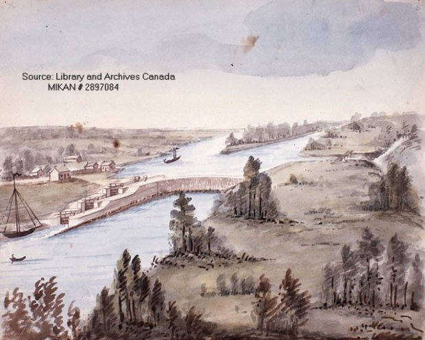
This 19th century painting depicts the area of Long Island and the village can be seen to the left. (IMAGE: Library and Archives Canada)
No trace of this multi-block town can be found today, but streets, a church, hotels and a post office were all part of this community back in the mid 19th century. Where did it go and why did it vanish without a trace? Let’s explore the area of this once-thriving community that seems to have vanished from time and space.
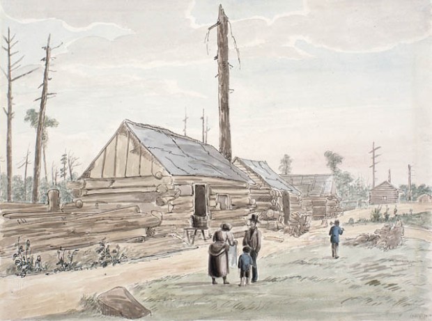
The village of Long Island seemed to comprise of log structures like these depicted in another painting from the 1800s. (Image: Library and Archives Canada)
First settled in the 1830’s during the construction of the Rideau Canal, the village of Long Island seems to be shrouded in obscurity, being difficult to pinpoint as to its exact location. The village at its peak in the mid-1860s contained general stores, two churches and its own post office. However, once a fellow by the name M. K. Dickinson built his stately stone flour mill in Manotick, many of the original settlers moved into Manotick and the village of Long Island went into decline.
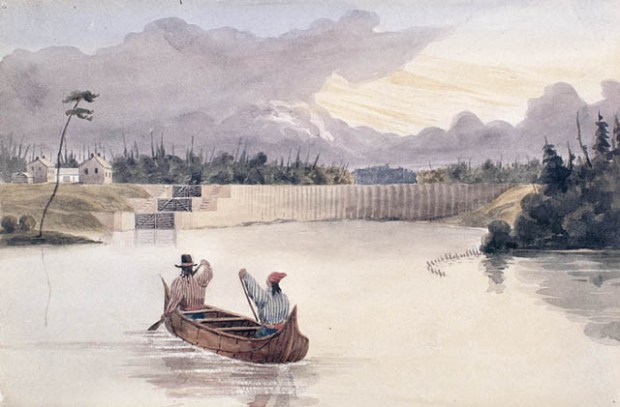
Some travellers by canoe approach the village of Long Island in the 1800s. (Image: Library and Archives Canada)
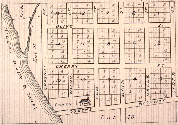
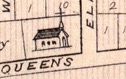
Not much evidence of its existence seems to have survived, just a few sketches and the map of the village as drawn for the County Atlas of 1880. So using that map and overlaying that with current Google Maps, we can pinpoint with accuracy where this ghost village was actually situated.

Map from 1880s showing the spread of the village on River Road.
The village must have gone into decline in the early part of the 20th century, as it seems to have disappeared from maps after that time. Was there a sweeping fire that tragically reduced the village to ash? Did the government expropriate the village and bulldoze it out of history? These details are unknown, but I welcome any feedback as to what happened to this village to make it disappear from both the landscape and map records.


Google Maps with an overlay of the map of the village from 1880s showing the extent of the streets, properties and the churchyard.
Once we overlay the old 1880 map of Long Island village on a current map we can see exactly the location of the ghost town, and many features of the boundaries match up with the current terrain. An investigation of this area would be necessary to search for clues of this lost village and to confirm that this was the right area.
Using map landmarks such as the church and creek, we can use those waypoints to begin our investigation.
INVESTIGATION


A quick search on Google Maps reveals that there is not much left of the vanished village. The map overlays show the general area where the village would have been located, so in order to investigate it properly, an on-site wander was necessary. You’d blink and miss it it if driving by it on River Road, as years of overgrowth and tress have obscured most of the original site. yet, one key element remains: a deserted graveyard in a field.
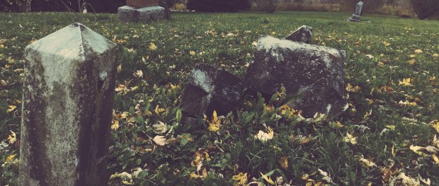
Stone obelisks and toppled gravestones mark the location of the village churchyard.

Toppled tombstones and stone obelisks dot the landscape at the site of what was once the church yard as sketched on the original map.

The church seems to have long since been removed, but its interred parishioners still remain, a ghostly reminder of the village long gone. A wander through and examination of the toppled stone markers shows dates in the 1880s, probably when the church was still functioning, but I could not see any dates after that so I am assuming the church yard was not used after the 1890s.
A further wander into the area revealed no trace of the village, only the creek that is mapped out on the original map.


The creek is still there, but no other evidence of this vanished town can be found in the tall grass and scrub of the area. A trek to the shore of the river reveals many bricks strewn around as if the town was bulldozed into the river. I would imagine with the proper permits and a metal detector and/or an archeological dig one could unearth many fragments of evidence that prove the village was once there, but alas, I do not have that access and leave it up to the proper authorities to investigate this ghost village further.
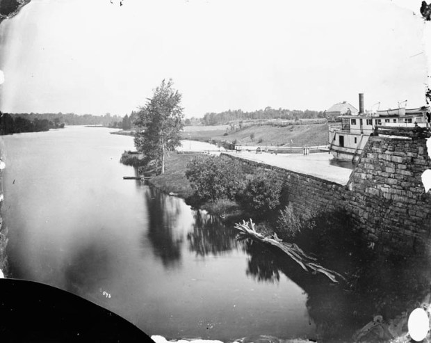
The Long Island Locks as photographed in the 1800s. (Image: Library and Archives Canada)


CONCLUSION
It is fascinating to know that a vibrant, thriving village once existed where nothing exists today, other than the swaying grasses of mother nature. The mystery of what happened to the lost village of Long Island will continue until more is known, but with the old maps, photos, and paintings from the past, we can somewhat piece together what is left on the barren landscape today, and glimpse that of yesterday. With a proper archeological investigation we may uncover more evidence than just the toppled graves of the people that once lived there, but until then, I recommend you check it out and walk through the Vanished Village of Long Island for yourself.
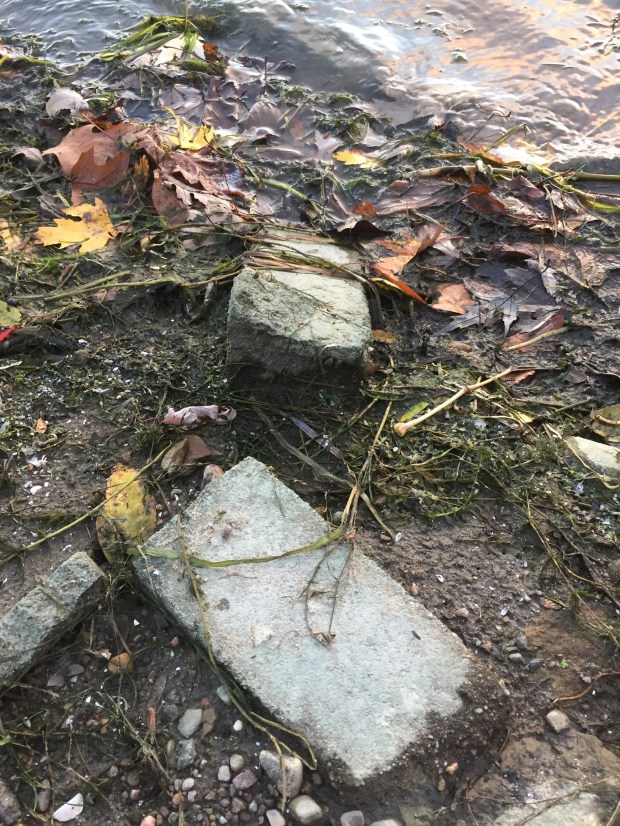
Toppled and discarded bricks line the shores of the Rideau River where the village used to be…was the village demolished and pushed into the river to be forgotten?
Andrew King, November 2017
SOURCES
Google Maps
Library and Archives Canada
McGill Digital Atlas Project

It is sad to see abandoned and derelict gravestones. If nothing else, it would be nice to find records of those buried there and commemorate their remains somehow. Do you have the name of the church?
Thanks Andrew! You always post such interesting stories. It is great that someone like you is around to do research like this. I hope others pick it up where you left off. Rosemary Ottawa
Fascinating, many thanks for doing these pieces!
Are we certain there was actually an entire village there, or was it just planned but never fully completed?
no, there was a complete village with homes, hotels, churches, etc.
For your next adventure…Check the Village of Fallowfield.
Incredible!
Hello Andrew,
What a coincidence for two summers ago we drove off River road toward the long lock and stopped beside an abandoned two storey wooden house. This on the right or north side of it.
We got out and Bob took pictures of the house. I walked beside it. I came upon a lovely clump of white fragrant hydrangeas. It had an eerie feel for it was so solitary and quiet.
I have been haunted by the scene and I wonder if that is the building that recently burned down.
Regards, Helen Cooper.
The ruins of that house that were left after the fire were just torn down two weeks ago. I think they took down the barn, too.
Thanks for the story. I spent a good number of summers at the Long Island RCMP camp in the 1950’s (as a kid). Don’t recall anyone mentioning the vanished town. My father was usually up on that type of history, but guess he didn’t know about it.
Thanks for the info.
In the 1950’s as a kid, I spent some time each year at the RCMP Camp at Long Island, I also knew someone who had a cottage there as well (across the dam). I don’t recall anyone mentioning a vanished village. My father was usually “up” on history like that, so I assume he never knew either.
According to Mel Rowat in the 1986 Gloucester Memories publication of the Gloucester Historical Society, between what is now known as the Rideau Road and the Long Island Locks Road, he remembers, in his school days (1918 to 1927), a Fee family farm. About 1860, before the Fees owned the property, a subdivision was started, as it was thought a village would grow there. A Methodist Church and parsonage were built, along with two or three houses.
Mr.& Mrs. John Scott and their four boys lived in the parsonage. The church, a small wooden building, had been sold to a farmer, and the houses had all but disappeared. Mr. Scott made good use of his small acreage to provide feed for his horse and cow while he worked at the Long Island Locks for the Department of Transport.
Mel Rowat lived all his life next to the locks, and the house built by his father in 1891 is still standing, but abandoned, sadly. Mel died in 1993, leaving no children.
I know this old house well, it caught fire last fall….thanks for the note and additional info. Cheers, AK
John Scott, from Aberdeenshire, was my grandfather, who bought the “parsonage” in 1901 and worked as a lockman at the Locks.
With the migration away from the proposed Long Island village to Manotick as the residential centre, the Methodist church sold the manse to Mr. Fee in the 1870s, who rented it to the Richard Dore family from England (a family later associated with old Ottawa South). My father lived his entire life in this home, and it was in the Scott family until 1996. During my life, there were a couple of burials in the abutting cemetery but the church building, which had been a simple hand-hewn timber structure and not as depicted in the registered plan of subdivision, was dismantled and purchased by a local farmer to be used as a farm building, and later destroyed by fire.
Great post – I love the history of this area. We moved to a house on Long Island in Manotick back in 2010 and I’ve really enjoyed researching the history of the area. There are some old books with mention of the Long Island village in the Manotick public library – seems like the people in the original village just shifted to cluster around the Mill when it was built around 1860.
I wrote a blog post about an old house that was right across the lock from where the village used to be – it was a beautiful old place, there one day and literally disappeared just a few weeks later, gone with barely a trace. http://danigirl.ca/blog/2012/09/07/dont-blink-or-youll-miss-it-manoticks-disappearing-houses/
Awesome! Great Post! Thanks for sharing!
Hello I currently live in the original Long Island Village, I am in lot 25 section 4 units 5,6,7,8 On what would have been Main St and Cherry St. I am excited to have just learned of this information and am interested to finding out more and possibly digging up history. I am thinking of doing some spot digs on my own, you know the good old amateur archeologist that has absolutely no clue what he is doing, what could go wrong right.
I did a quick bit of research on OnLand and found that the majority of the lots were owned by the Fees, purchased in 1874, and these were later expropriated by the County of Carleton between 1961 and 1964. The plan was registered in 1861, and very few of the lots went to other individuals. Legally, the lots still exist. I think the majority of the vacant lots today were never developed, but continued to be farmed for some time after.
Prior to 1861 the land belonged to a Mr. Edmond Burritt. The village does not have appeared to have existed prior to this time, although the original township lot started to get carved up as early as 1845. This is fairly typical as most people could not afford or farm a full 200 acre township lot. The very first parcel of land severed from the township lot in the area was the Curry property next to the church property. The second property to be severed was the church property in 1858. This means the church was probably the first building to be built there. Mr. Burritt likely saw potential in this area , since it had a church and easy access to a commercial waterway. Like many other “schemes” that were proposed over the years, the village never seems to have really taken off. Many of the log buildings seen in early paintings could have been leased out on a temporary basis, and probably didn’t survive very long. The old county atlases can be misleading as subdivided areas were shaded to resemble built-up areas… wishful thinking perhaps.
Many other small villages were subdivided in the 1800’s and early 1900’s but save for a few houses, little was built. A prime example is the village of Cheney Station which existed just west of Cheney in Russell County. The railway was built in 1895 and abandoned in 1927, so there was little time for the village to become established. If you want other examples worth looking into, I can compile a list for you.
good research, Chris. Thanks!