BEERS OF BYTOWN
Ottawa’s thirst for craft beer seems unquenchable with close to twenty craft breweries now operating in the Nation’s Capital which is pretty good for a town others like to call “The Town That Fun Forgot”. Since Ottawa’s first tavern opened in 1819 (see previous story on that pub here), Ottawa has always been a burg of beer drinkers, so it’s no surprise to see our local breweries doing so well. As these new breweries open and pour their wares at an alarming rate, let’s not lose sight of our important beer history and see if we can find Ottawa’s first brewery, a brewery that I believe was located at the base of this nation’s government, Parliament Hill.
In researching the W5 of this city’s very first brewery, I came across an excellent account of Ottawa’s food and drink lineage titled “Ottawa Food: A Hungry Capital” published in 2014 by Don Chow and Jennifer Lim which examines the history of food and drink in the National Capital Region. They mention it was difficult to pinpoint exactly Bytown’s (Ottawa’s former name) first brewery, but they believe it was “The Victoria Brewery” that operated from 1829 to 1899 at the corner of Rochester and Wellington St, in the now flattened Lebreton Flats neighbourhood. Built by John Rochester, it produced a double stout and an India Pale Ale. By delving into further research I think I have uncovered further information that reveals there may have been an even earlier brewery operating in Bytown.
FIRST BREWERY?

An early sketch of how Bytown looked in 1825.
A great piece at Bytown.net shows that in 1819 a Ralph Smith from King’s County, Ireland built a house near Richmond Landing. An excerpt from the book by Nicholas Davin “An Irishman in Canada” published in 1877 reveals that this Ralph Smith built the first house on the south shore of the Ottawa River, the second being the hut of Nicholas Sparks. After arriving on the shore near Richmond Landing in 1819 and building his house there, Smith got to work operating a brewery and a ferryboat to take people and things across the river to Wrightstown (now Gatineau/Hull).
So that means if Smith built a brewery in 1819, that pre-dates the Victoria Brewery by ten years, making it the very first. Now you may say, that’s all fine and dandy to say he was the first, but as we all know, the proof is in the pudding.
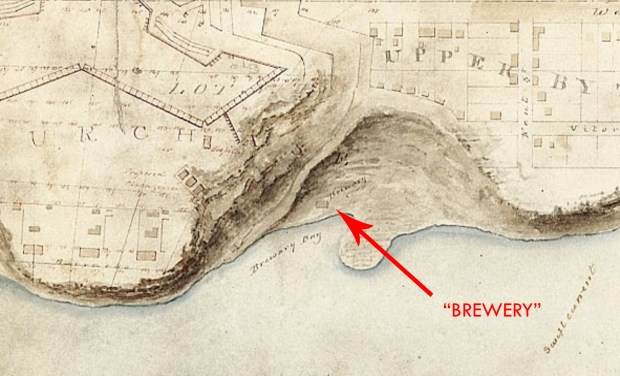
MAPS TO THE PAST

The map from 1831 of Bytown at the Library and Archives Canada shows a brewery just west of what is now Parliament Hill. (MIKAN 4135481)
Old maps of Bytown/Ottawa have always fascinated me, providing a glimpse back in time through their carefully inked information, recording places in a time that was never photographed. I can sit down and pour over old maps for hours, studying the fascinating places that came and went in Ottawa, and one such map is the one at the Library and Archives Canada labelled MIKAN 4135481 Bytown 1831.

Overlaying the 1831 map over the current Google Map.

This map drawn to show the topography of the riverfront of what is now Parliament Hill, back then “Barrack’s Hill” because it was a military outpost, clearly labels a body of water on the south shore, just west of the Hill as “Brewery Bay”. A closer look reveals that there is a small building labelled “Brewery”. Bingo. This is likely the proof of Smith’s south shore brewery that he started twelve years earlier. But hang on you say, not so fast Mr. King, because another source says that a certain Mr.Burke opened the first brewery in that area. Yet that was not operational until 1844, well after the 1831 brewery that is marked on the map. My money is always on maps, and that 1831 map is showing Smith’s brewery, the first one.
WHERE EXACTLY IT IS

If we use that map from 1831 as proof of Ottawa’s first brewery, we can then extrapolate through time and find its current whereabouts using GoogleMaps and overlays of each.
Doing so reveals that the shoreline behind parliament went through a rise in waters, I’m guessing from the Carillon Dam being built downriver in 1964 and put much of the river shoreline upstream from it underwater.

The first brewery itself seems to have been located just inside Brewery Bay, escaping the flooding waters which submerged the peninsula, which can sometimes be seen at low water time during the year. If this location is correct, then the ruins of Ottawa’s first brewery either lie in the wooded area off the bike path, as shown in the images below, are submerged underwater, or were demolished by some government works building parking lots or whatever else they built down at the river.

The area of “Brewery Bay” looking east…note the submerged peninsula to the left, just a few inches underwater. (Google)
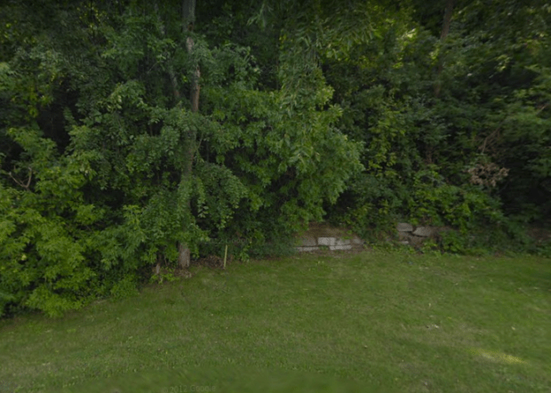
The forested area roughly where Ottawa’s first brewery was likely located. (Google)
There are some rocky blocks visible through Google Streeview in that area, I’m not sure if those are part of the former brewery or some other post-brewery structure. Once the warmer weather returns and the snow melts it might be a good idea to scope it out for any signs of the brewery, which of course I’ll bet is on NCC property.
If anyone else would like to confirm or deny that this is the first brewery location, then please feel free to chime in. In the meantime, let’s pour a cold beer and enjoy remembering where exactly Ottawa’s first brewery was located.
Andrew King 2018
SOURCES
Library and Archives Canada
http://www.bytown.net/breweries.htm
http://www.bytown.net/theirishmanincanada.htm
Google Maps
GeoOttawa

Isn’t that directly below where the Brading brewery was?
no, Bradings was further up where the Park of The Provinces is now.
Yet another terrific glimpse into Ottawa’s past …
As with all your posts, you provide a great deal of insight not normally available to the casual citizen/historian. Ottawa is very lucky to have you.
P.S. Congratulations on your new position with the Byward Market !
Hi Stephen, thanks for the note and I appreciate your interest in my blog…I simply enjoy bringing these events of the past into the present…thanks for reading! and yes, Byword Market logo design is fun!
I made the same discovery in May 2013 on the map of Burrows (in French):
http://geo-outaouais.blogspot.ca/2013/05/disparitions-durables-suite-no-2.html
I like your work with the Burrows map and the satellite photo.
Awesome! Thanks for the note and your shared interest in our past! My French is poor but I can appreciate an excellent blog when I see it…well done!
Cool stuff. I’m enjoying your blog.
It can be tricky lining up old waterfronts. Yes, partly due to flooding as you mention, but also because in this case the pathway below the Hill is all on landfill. Early photos can be found that show the Hill dropping straight down to the water. Yes, there was a low, sloping area between the Hill and where the Supreme Court is now, which is where the brewery may have been located, though that also got filled to create the current parking lot.
Agreed, that waterline has changed often…I wonder if we could find some relic of the brewery if we tried digging around there?
Mr. King, just a short note to tell you how much I have enjoyed your various writings about early Bytown/Ottawa. I am trying to find out more about Andrew Barrie (Berry?), the lesser-discussed partner in Firth & Berry’s Tavern. I understand he was a military man prior to coming here. He and Sylvester Dempsey were co-signers on my ancestor’s tavern keepers’ recognizance of 1819 (for Steel’s Tavern, present day Fallowfield). I am supposing their main connection was their service in the British army. All the best to you and yours in the new year !
Hi John, Thanks so much for your note and for enjoying my blog. I have yet to come across any mention of Andrew Berry and his connections to Bytown, but I suggest checking with the Library and Archives. Also, the Bytown.net site is a great resource. Good Luck! -AK
Hi Andrew – He was Mr. Firth’s partner at the tavern, and was formerly a Royal Artillery man. I’ll look forward to reading more of your research ! All the best, – John
Hi Andrew, You might want to take a look at this page (https://www.historymuseum.ca/cmc/exhibitions/hist/hull/rw_31_ie.html) where Ralph Smith is mentioned. It says: In 1832, Ralph Smith was hired (by Philemon Wright) for five years and three months, at the rate of �80 a year and the use of two acres of land, but he was not permitted to use more water than required for the brewery.
Ralph Smith is frequently mentioned in the Wright Papers and was definitely hired to be the Wright’s brewmaster. There is no mention in the papers of when he arrives in the area.